
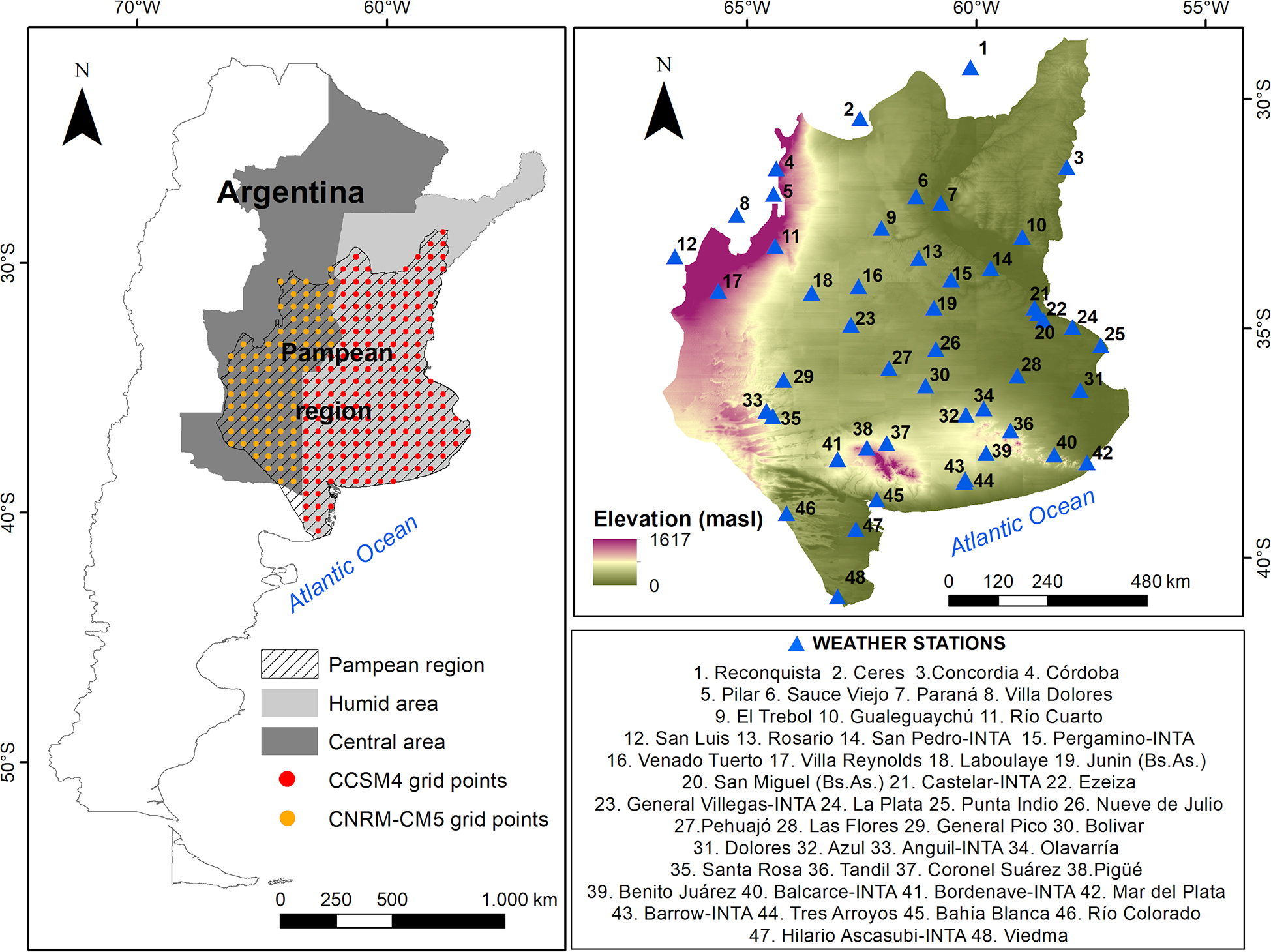
Fig. 1.
Location of the Pampean region, Central and Humid areas and meteorological stations. Weather stations in close proximity due to map scale constraints are representing distinct locations with unique local climate variations.
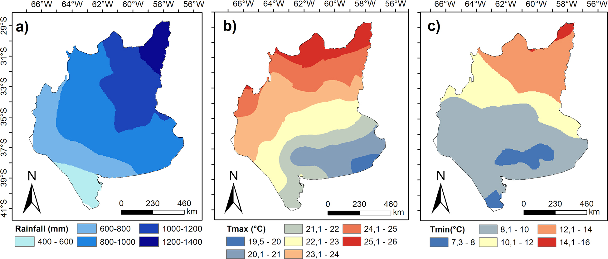
Fig. 2.
A – mean annual precipitation (mm), B – mean annual maximum temperature (°C), and C mean annual minimum temperature (°C) in the Pampean region during the period 1960–2023.
Table 1.
Climate precipitation indices calculated in the present study.
| Indices | Name | Definition | Units |
|---|---|---|---|
| Prcptot | Annual precipitation on wet days | Annual precipitation on wet days (pp > 1 mm) | mm · a−1 |
| CDD | Consecutive dry days | Maximum number of consecutive days with pp < 1 mm | days |
| CWD | Consecutive wet days | Maximum number of consecutive days with pp > 1 mm | days |
| Rx1day | Maximum amount of precipitation occurred in 1 day | Wettest day of the year | mm |
| Rx5day | Maximum amount of precipitation occurred in 5 days | Five consecutive days with the highest precipitation | mm |
| R10 | Days with heavy precipitation | Annual count of days when pp > 10 mm | days |
| R20 | Days with very heavy precipitation | Annual count of days when pp > 20 mm | days |
| R30 | Days with torrential precipitation | Annual count of days when pp > 30 mm | days |
| R95p | Very wet days | Amount of precipitation when pp > 95th percentile | mm |
| R99p | Extremely wet days | Amount of precipitation when pp > 99th percentile | mm |
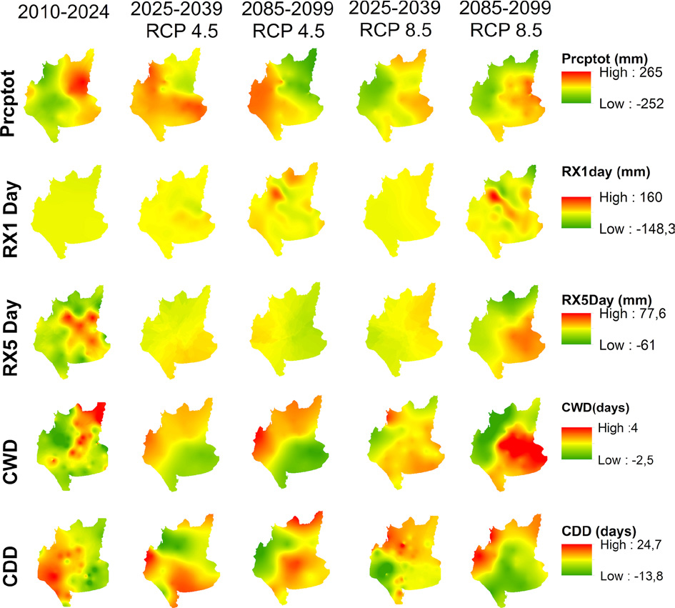
Fig. 3.
Spatial trends in five precipitation climate indices (Prcptot, RxlDay, Rx5Day, CWD and CDD) for present (2010–2024), near future (2025–2039) and far future (2085–2099) under RCP 4.5 and RCP 8.5 scenarios. Rate of change per 15 years using Sen’s slope method. Red indicates increases, green indicates decreases. CDD, consecutive dry days; CWD, consecutive wet days; RCP, representative concentration pathways.
Table 2.
Regional average rate of change and number of stations showing a significant decrease (D) or increase (I) in precipitation indices during five periods: present (2010–2024), near future (2025–2039), and far future (2085–2099), under RCP 4.5 and RCP 8.5 scenarios. ‘RA’ indicates the regional average rate of change over each 15 years, calculated using Sen’s slope, not the actual precipitation values (presented as mean ± standard deviation across all 48 stations); ‘N°’ is the number of weather stations showing the directional change (positive or negative); and ‘S’ indicates the number of stations where these changes represent statistically significant trends according to the Mann–Kendall test with p < 0.05 as the significance threshold.
| Indices | RA | 2010–2024 | RA | 2025–2039 RCP 4.5 | RA | 2085–2099 RCP 4.5 | RA | 2025–2039 RCP 8.5 | RA | 2085–2099 RCP 8.5 | |||||||||||||||
|---|---|---|---|---|---|---|---|---|---|---|---|---|---|---|---|---|---|---|---|---|---|---|---|---|---|
| D | I | D | I | D | I | D | I | D | I | ||||||||||||||||
| N° | S | N° | S | N° | S | N° | S | N° | S | N° | S | N° | S | N° | S | N° | S | N° | S | ||||||
| Prcptot (mm) | –120 ± 91 | 28 | 20 | 20 | 5 | 63.2 ± 33.7 | 11 | 0 | 37 | 4 | 75.4 ± 52.5 | 22 | 2 | 26 | 7 | 11.9 ±3.2 | 23 | 7 | 25 | 3 | 120.3 ± 50 | 17 | 0 | 31 | 26 |
| RXIDay (mm) | –23.6 ± 4 | 30 | 16 | 18 | 2 | 13.7 ±7 | 17 | 0 | 31 | 8 | 12.3 ± 5 | 15 | 0 | 33 | 2 | 13.4 ± 8 | 21 | 2 | 27 | 0 | 50.3 ± 15.1 | 19 | 0 | 29 | 18 |
| RX5Day (mm) | –28.7 ± 14 | 30 | 14 | 18 | 2 | 20.7 ±10 | 18 | 0 | 30 | 4 | –14.6 ± 8 | 28 | 0 | 20 | 5 | 21.9 ± 7 | 23 | 0 | 25 | 0 | 37.4 ± 16 | 17 | 2 | 31 | 20 |
| CWD (days) | –1 ± 0.7 | 26 | 19 | 22 | 9 | 1.4 ±1.1 | 23 | 0 | 25 | 10 | 1.3 ±0.7 | 23 | 6 | 25 | 2 | 1.5 ±1.1 | 20 | 4 | 28 | 0 | 2.7 ±0.7 | 13 | 3 | 35 | 26 |
| CDD (days) | 16 ±11 | 17 | 3 | 31 | 19 | 9.5 ±1.7 | 23 | 1 | 25 | 0 | 7.5 ±3 | 14 | 2 | 34 | 4 | –4.7 ±1.1 | 28 | 4 | 20 | 1 | –9.4 ± 1.9 | 35 | 24 | 13 | 6 |
| R10 (days) | –3.9 ± 2 | 32 | 21 | 16 | 4 | 4.2 ±2 | 13 | 0 | 35 | 4 | 3.9 ±1.1 | 24 | 4 | 24 | 1 | –4.3 ± 1.3 | 26 | 1 | 22 | 6 | 6.3 ±1 | 18 | 3 | 30 | 29 |
| R20 (days) | –4.3 ± 2 | 30 | 16 | 18 | 8 | 1.3 ±1.2 | 19 | 2 | 29 | 1 | –4.9 ± 1.9 | 30 | 3 | 18 | 4 | –1.3 ± 0.9 | 25 | 2 | 23 | 1 | 6.9 ±1 | 13 | 8 | 35 | 23 |
| R30 (days) | 1.6 ±0.3 | 14 | 4 | 34 | 19 | –2.1 ± 0.3 | 28 | 8 | 20 | 3 | –1.6 ± 0.2 | 28 | 5 | 20 | 2 | –2.5 ± 0.2 | 39 | 11 | 9 | 2 | 1.8 ±0.2 | 11 | 2 | 37 | 26 |
| R95p (mm) | –162.3 ± 30.2 | 27 | 17 | 21 | 9 | –146.3 ± 40.3 | 29 | 5 | 19 | 3 | –112.3 ± 16.8 | 29 | 11 | 19 | 5 | –98.3 ± 23.1 | 38 | 8 | 10 | 1 | 190.3 ± 45.6 | 16 | 9 | 32 | 19 |
| R99p (mm) | 76.2 ± 19.3 | 10 | 2 | 38 | 19 | 79.4 ± 25.9 | 16 | 2 | 32 | 7 | 72.3 ± 18.5 | 17 | 3 | 31 | 5 | –112.7 ±13.1 | 39 | 5 | 9 | 2 | 83.1 ± 16.7 | 6 | 0 | 42 | 29 |
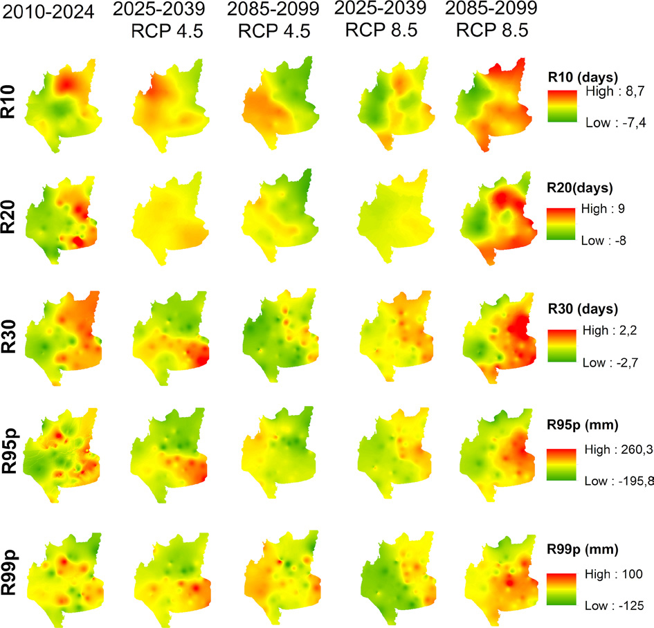
Fig. 4.
Spatial trends in five extreme precipitation indices (R10, R20, R30, R95p and R99p) for present (2010–2024), near future (2025–2039) and far future (2085–2099) under RCP 4.5 and RCP 8.5 scenarios. Rate of change per 15 years using Sen’s slope method. Warm colours indicate increases, cool colours indicate decreases. RCP, representative concentration pathway.