
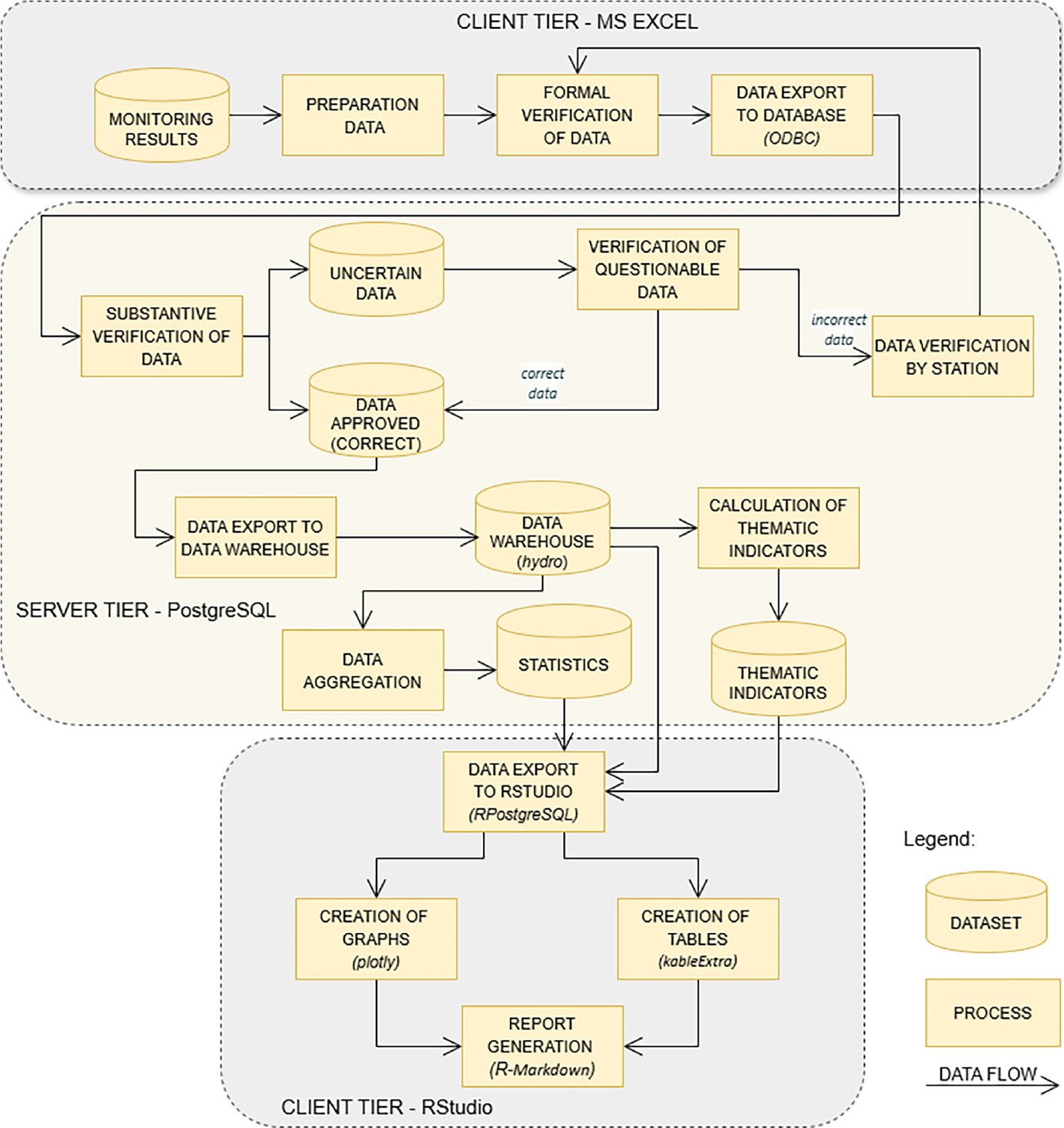
Fig. 1.
Diagram illustrates the structure of the framework for processing and reporting hydrological monitoring data.
Table 1.
Summary of thematic indicators for hydrological data with formulas according to Bajkiewicz-Grabowska et al. (1993) and Ozga-Zielinska, Brzezinski (1997).
| Parameters | Description | Formula |
|---|---|---|
| Q | Discharge in cubic meters per second | |
| P | Precipitation in millimetres | |
| NQ, SQ, WQ | Minimum (NQ), mean (SQ) and maximum (WQ) values calculated based on daily discharge (Q) | |
| AQ | Relative amplitude of discharge | |
| Long-term discharge characteristics | ||
| WNQ, WSQ, WWQ | Maximum extreme discharges are the highest values calculated using annual NQ, SQ and WQ values. | |
| NNQ, NSQ, NWQ | Minimum extreme discharges are the lowest values calculated, respectively, using annual NQ, SQ and WQ values. | |
| SNQ, SSQ, SWQ | Mean discharge is the mean value calculated using annual NQ, SQ and WQ values. | |
| Hydrological parameters | ||
| q | Specific discharge is a discharge of water per unit area of a drainage basin expressed in litre per second per square kilometres. | A – catchment area |
| O | Runoff depth is calculated as the runoff volume from a drainage basin divided by its area in a specific time, and is expressed in millimetres. | A – catchment area |
| a | Runoff coefficient is the ratio of runoff depth to precipitation depth. | |
| k | Monthly discharge coefficient, k > 1 indicates months with the mean discharge (SQ) above the annual mean discharge calculated for the multi-year period, whereas k < 1 shows the months with mean discharge (SQ) below the annual mean discharge calculated for the multi-year period. | |
| Flow level categories | ||
| HH | High above normal | Q ≥ SWQ |
| HM | Above normal | SWQ ≥ Q ≥ NWQ |
| NF | Normal flow | |
| LM | Below normal | SNQ ≤ Q ≤ 0.5 · (NSQ + WNQ) |
| LL | Low below normal | Q ≤ SNQ |
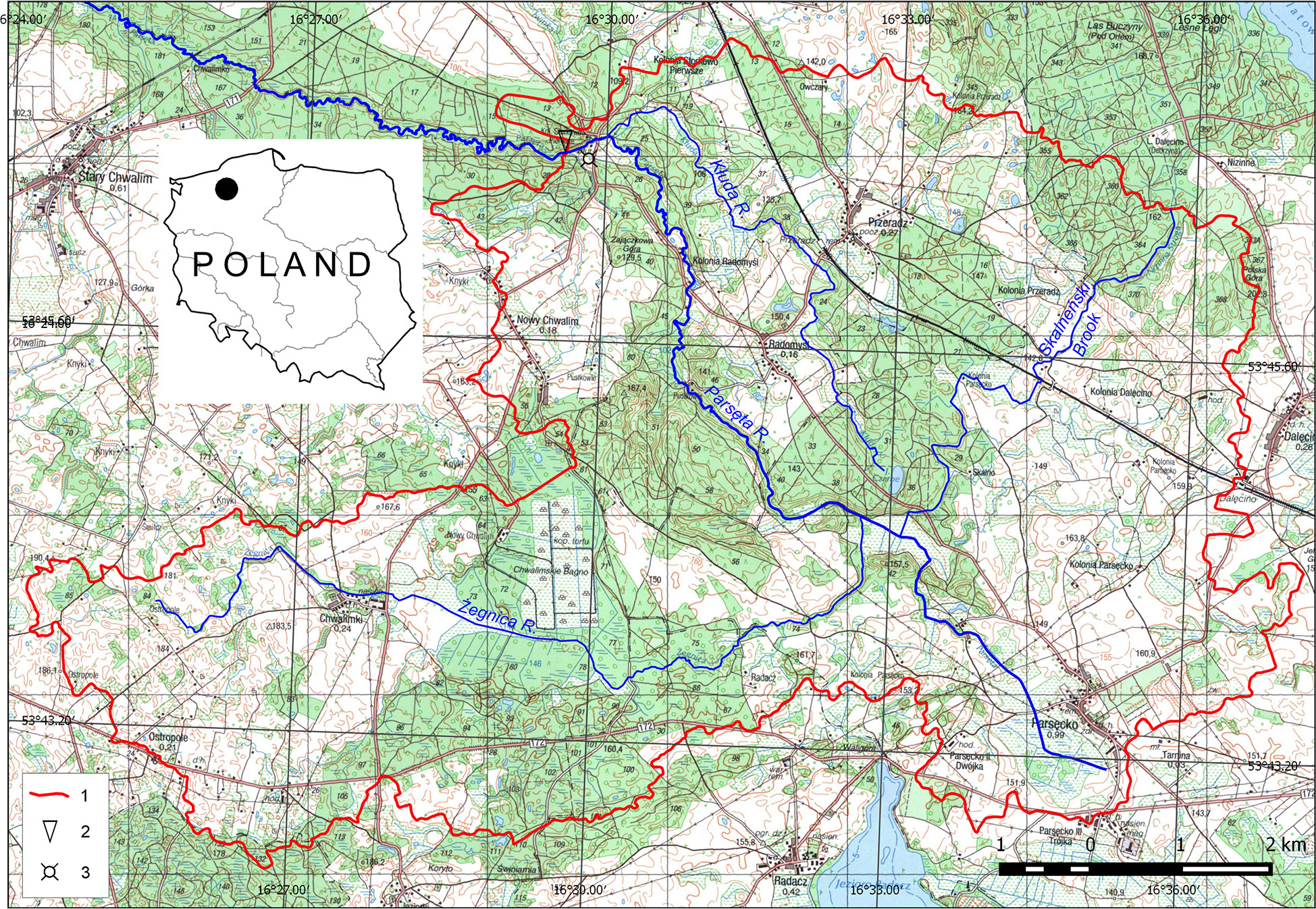
Fig. 2.
Upper Parsęta catchment.
1 – watershed of the upper Parsęta catchment, 2 – the hydrometric station closing the upper Parsęta catchment, 3 – meteorological station.
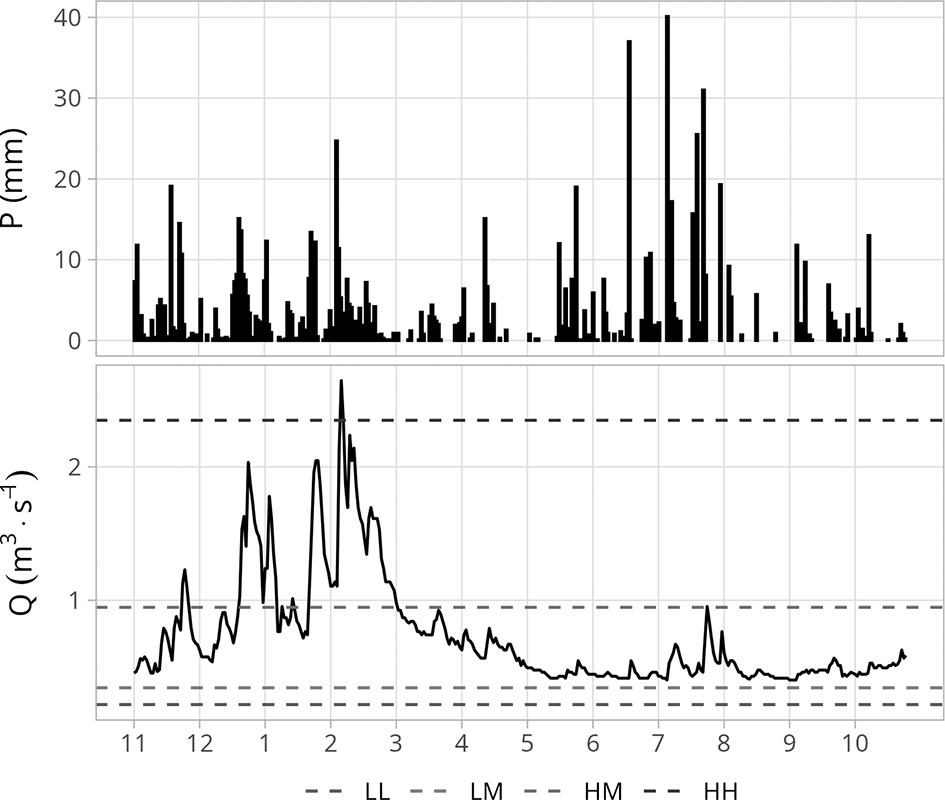
Fig. 3.
Variability of daily values of precipitation P – and discharge Q – in the hydrological year 2024. The discharge plot also shows the boundaries of flow level categories.
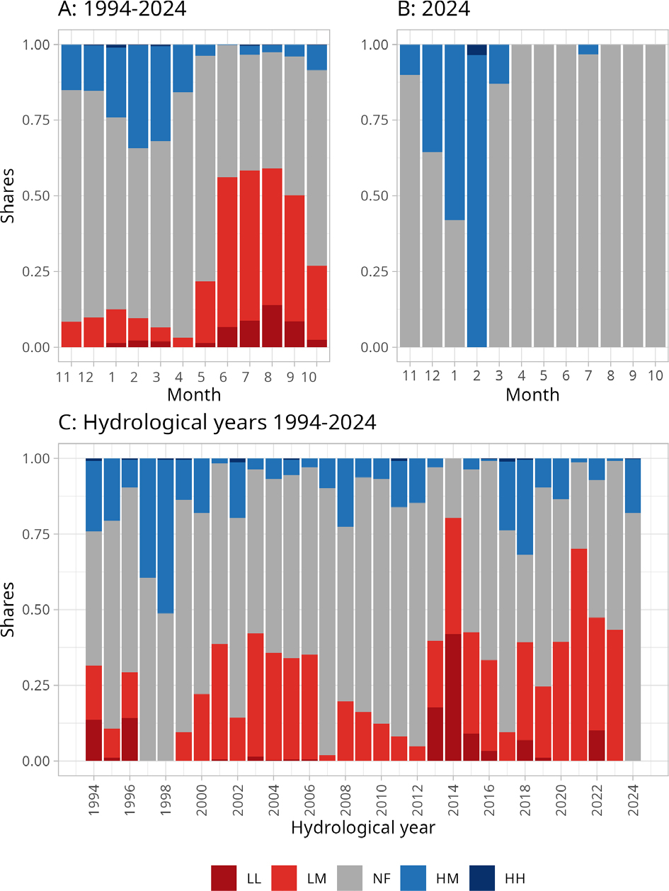
Fig. 4.
Shares of flow level categories: A – in individual months of 1994–2024, B – in the hydrological year 2024 and C – in hydrological years 1994–2024.
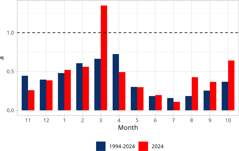
Fig. 5.
Variability of monthly values of the runoff coefficient (a) – in the hydrological year 2024 in comparison to the monthly runoff coefficient values calculated based on 1994–2024.
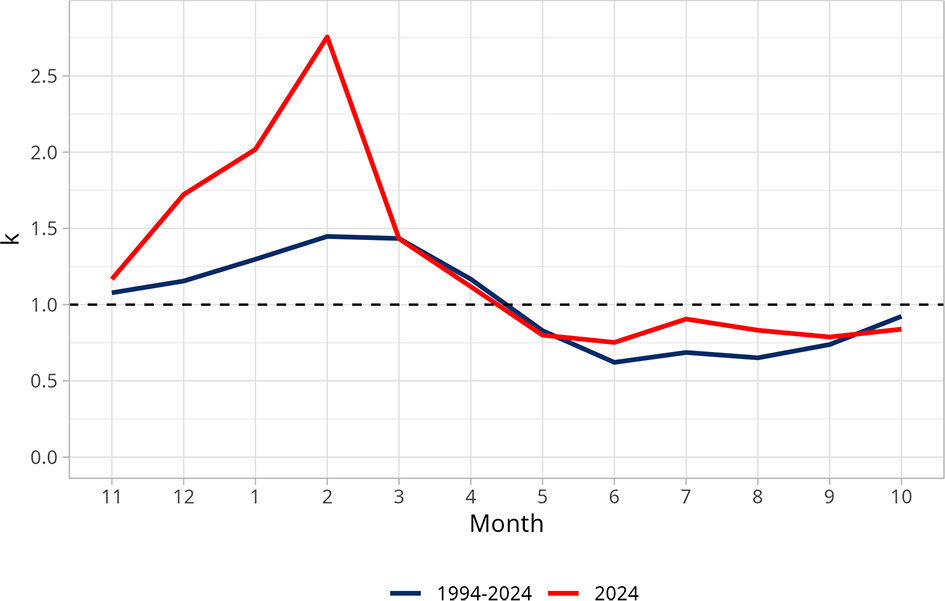
Fig. 6.
Variability of monthly discharge coefficient (k) – values in the hydrological year 2024 compared to the period 1994–2024.