Geotourism is a form of outdoor and sightseeing tourism. The objective of geotourism is to discover and learn about the elements of abiotic nature and the processes that shape them (Hose 1995, 2000, 2008, 2011, Stueve et al. 2002, Słomka, Kicińska-Świderska 2004, Joyce 2006, Newsome, Dowling 2006, 2010, Migoń 2012). The purpose of geotourism trips is to visit and become familiar with objects of abiotic nature that were formed as a result of various geological and geomorphological processes (Słomka, Kicińska-Świderska 2004, Kurek 2008). Currently, geotourism is most developed in mountainous areas, deserts, coastal areas and river valleys, as evidenced by the numerous publications describing such attractions (Borówka, Nowak 2005, Żaba 2005, Dmytrowski, Kicińska-Świderska 2006, Łodziński 2007, Strzeboński, Słomka 2007, Mateos et al. 2011, Hlavňová, Pavolová 2013, Krzeszowska 2013, Farsani et al. 2014, Bąk et al. 2016, Rogowski 2016). In addition to natural areas, geotourism is also promoted in anthropogenic facilities related to the exploitation of natural resources, that is, former mines, historical technological objects or hydrotechnical facilities (Baláž et al. 2008, Kowol, Różycki 2008, Kurek 2008, Rybár, Carvajal 2014). Also interesting is the educational approach to geosites that require special climbing equipment for exploration (Bollati et al. 2018, 2024, Knight, Bollati 2024). Travelling and exploring places of interest from the point of view of abiotic nature may require special qualifications, such as those related to climbing and underground exploration. Geotourism can also take the form of business tourism when it involves professionals (especially natural scientists) attending various types of scientific conferences (Migoń 2012). Currently, the development of geotourism is mainly influenced by scientific centres that promote natural heritage, education in the field of natural sciences and the preparation of popular educational publications and maps. It is mainly promoted by geologists and geographers, as well as lovers of abiotic nature (Kurek 2008).
Objects of abiotic nature that are the subject of geotourism are defined as geosites or geomorphosites. They are places where it is possible to learn about and obtain information on various forms and processes related to abiotic nature (Reynard 2004, Słomka, Kicińska-Świderska 2004, Dmytrowski, Kicińska 2011, Migoń 2012). They fulfil scientific, educational, tourist, and conservation functions (Koźma 2008).
Orava, Liptov, and Spiš are ethnographic regions surrounding the Tatra Mountains (from the west, south and east). These areas have very well-developed tourist facilities and are well-connected. In addition, they are characterised by a rich culture, which is visible in the architecture, regional folk clothes and all sorts of traditions; this undoubtedly confirms this area as one of the most popular tourist areas in Slovakia (Kollár 1999a, b, Lacika 1999a, b).
This article aims to identify the most attractive geosites, inventory them and perform expert evaluation. This is based on several elements, including: (i) the representativeness of observable features, rocks and landforms and the geological, hydrogeological and geomorphological processes that led to their formation, (ii) the degree of uniqueness of the selected sites, presented on a regional and national scale, (iii) the degree of landscape diversity and (iv) the scientific value of geosites demonstrated by domestic and international scientific publications. The assessment of the cognitive and educational value of geosites was complemented by an analysis of selected tourism criteria, that is: (i) the accessibility of the site and the degree of its degradation, (ii) the scenic value, including the viewpoint extent, (iii) the level of promotion of the geosite, (iv) the legal status of the area where the geosite is located and (v) an assessment of its location in relation to accommodation and complementary services, and other tourist attractions.
Among the publications related to geotourism, there are only a few works concerning the region of Orava, Liptov and Spiš. Some authors emphasised the geotouristic values of the Podhale flysch (e.g. Ptaszek 2005, 2007, Krobicki, Golonka 2008b, Chrobak 2015, 2016, 2018, Chrobak, Bąk 2019). Many geotourism publications refer to the Pieniny Mountains and have been indirectly influenced by the idea of creating a cross-border Pieniny Geopark (Birkenmajer 1962, 1979, 2014, Alexandrowicz et al. 1997, Golonka, Krobicki 2007, Krobicki, Golonka 2008a, Golonka et al. 2014a, b, Jacko et al. 2014). Geosites are presented in the Slovak Paradise (Slovenský raj) National Park (Lukáč et al. 2010, Janočková et al. 2012, Janočková, Janočko 2013), the Dobšinská ľadová jaskyňa Cave (Gasinec et al. 2013) and selected areas of the Spiš region (Rybár, Compľová 2013, Štrba et al. 2022, Čech et al. 2025).
A detailed inventory of geological localities in the area of Podhale, Orava, Liptov and Spiš was created as part of the doctoral thesis of the first author of this article and subsequently published in the form of a monograph (Chrobak, Bąk 2019). Objects of outstanding geological value are also described in the central register of geosites administered by the State Geological Institute of Dionýz Štúr (Liščák et al. 2012).
All methods of geosite assessment described in the scientific literature are based on point valuation. According to this method, different weights are assigned to defined criteria. Among the many assessment methods described so far, relating to different areas of mountain and foothill relief (Alexandrowicz et al. 1992, Serrano, González-Trueba 2005, Panizza, Mennella 2007, Reynard et al. 2007, Zouros 2007, Koźma 2008, Pereira, Pereira 2010, Rodrigues, Fonseca 2010, Rybár 2010, Bruschi et al. 2011, Coratza et al. 2011, Dmytrowski, Kicińska 2011, Fassoulas et al. 2012, Brilha, 2016), in this article, two methods were used: those presented by Pereira and Pereira (2010) and Fassoulas et al. (2012). According to the authors of these papers, these methods comprehensively evaluate geological sites of mountain and foothill relief; the first one was used for the Montesinho Mountain Park in Portugal and the second for the Psiloritis Geopark and the Lasithi Mountains on Crete. The criteria used in these two papers were the basis for the introduction of a modified assessment method of the geosites in the Sub-Tatra region (Chrobak 2018, 2021, Chrobak, Bąk 2019) that also belongs to the group of point valuation methods.
The assessment method used in this paper assumes that geosites are evaluated according to two sets of criteria: cognitive-educational and tourist criteria. The criteria for assessing cognitive and educational value were based on those presented in Pereira and Pereira (2010), while the tourist criteria were based on those presented in Pereira and Pereira (2010) and Fassoulas et al. (2012) (Table 1).
Point values of elements valorising geosites.
| E | Cognitive – Educational criteria |
| U | The uniqueness of the site in relation to the Sub-Tatra region |
| 0 | More than five examples of similar geosites in the region |
| 2.5 | Three to five examples of similar geosites in the region |
| 5 | Two to three examples of similar geosites in the region |
| 7.5 | Geosite is very special |
| 10 | The only such geosite in the region |
| Z | Degree of degradation (destruction) of the site |
| 0 | The site is damaged by human activity |
| 2.5 | The site is destroyed due to natural processes |
| 5 | The site is damaged, but has retained its basic geological and geomorphological features |
| 7.5 | The site is slightly damaged but still retains important geological and geomorphological features |
| 10 | The site is not damaged |
| R | Representativeness of geological, hydrogeological, hydrological and geomorphological processes and their educational value |
| 0 | Low representativeness and lack of educational value |
| 3.3 | Medium representativeness and low educational value |
| 6.7 | Geosite is a good example of natural processes, but recognition and interpretation are difficult for non-scientists |
| 10 | Geosite is a good example of natural processes and has a high educational value |
| Zk | Degree of landscape diversity |
| 0 | Lack of diversity (1 type of geomorphological process that forms the landscape) |
| 3.3 | Low diversity (2 types of geomorphological processes that form the landscape) |
| 6.7 | Average diversity (3 types of geomorphological processes that form the landscape) |
| 10 | High diversity (4 or more types of geomorphological processes that form the landscape) |
| Wg | Other features related to abiotic nature within the site and in its immediate vicinity |
| 0 | No other elements |
| 3.3 | Other elements of inanimate nature, but not related to geographical location |
| 6.7 | Other elements of inanimate nature related to geosite |
| 10 | Occurrence of other geosites within 2 km |
| L | Scientific value of geosite as expressed in scientific literature |
| 0 | There is no scientific literature describing this geosite |
| 5 | Geosite described in the national scientific literature |
| 10 | Geosite described in the international scientific literature |
| SK | Uniqueness of the geosite in comparison with other similar sites in Slovakia |
| 0 | More than five examples of similar geosites |
| 3.3 | Three to five examples of similar geosites |
| 6.7 | Two examples of similar geosites |
| 10 | There are no similar geosites |
| T | Tourist criteria |
| W | Scenic values |
| 0 | Difficult observation of the object or the object is not visible at all |
| 2 | The object can only be observed using special equipment |
| 4 | Visibility is limited by trees or lower vegetation |
| 6 | Good visibility, but you have to move around for full observation |
| 8 | Good visibility for all elements (partially grass-covered object) |
| 10 | Perfect visibility for all components |
| Pw | Visibility range |
| 0 | No view |
| 2.5 | Limited view with a range of 90° |
| 5 | Semi-circular view with 180° |
| 7.5 | View to three sides (270°) |
| 10 | Unlimited circular view (360°) |
| D | Object accessibility |
| 0 | Difficult to access object; only with the use of special equipment |
| 2 | Accessible on foot; parking more than 2000 m away |
| 4 | Object is accessible by car and/or bicycle; parking more than 1000 m away |
| 6 | Object is accessible by car and/or bicycle; parking at a distance of 500–1000 m |
| 8 | Object is accessible by car and/or bicycle; parking within 500 m |
| 10 | The object is accessible by car and local means of transport; bus stop within 500 m, parking within 100 m |
| Ot | Current form of accessibility as a tourist attraction |
| 0 | The site is not known in tourist literature, is not a tourist attraction and is not promoted |
| 3.3 | The site is known in tourist literature, but it is not used as a tourist attraction or promoted |
| 6.7 | The site is known in tourist literature, it is promoted, but it is not used as a tourist attraction |
| 10 | The site is well known in tourist literature, it is promoted and used as a tourist attraction |
| O | Legal status of geosite protection |
| 0 | Strict security measures, no access to the object |
| 3.3 | Partial protection with precise instructions for object accessibility |
| 6.7 | No protection with full access to the object |
| 10 | Partial protection without additional restrictions related to the accessibility of the object |
| Ud | Facilities and additional services (gastronomy, souvenir shops) |
| 0 | Accommodation and additional services more than 5 km away |
| 2.5 | Accommodation and additional services 2–5 km |
| 5 | Accommodation and additional services 500 m to 2 km |
| 7.5 | Accommodation and additional services between 100 m and 500 m |
| 10 | Accommodation and additional services within 100 m |
| It | Presence of other tourist attractions |
| 0 | There are no other tourist attractions within a radius of more than 5 km |
| 2.5 | The nearest tourist attraction is 2–5 km away |
| 5 | The nearest tourist attraction is 500 m to 2 km away |
| 7.5 | The nearest tourist attraction is 100-500 m away |
| 10 | The nearest tourist attraction is less than 100 m away |
The sums of the values related to each criterion were then divided by the maximum sum that could be obtained for each criterion so that all values were in the range 0–1. On this basis, four groups were distinguished (Table 2). The boundaries between them were adopted on the basis of the proposals presented in Warszyńska (1970).
Geosite classification based on the results of the valorisation.
| Group | Point value | Definition |
|---|---|---|
| I | >0.7 | Object with special cognitive, educational/tourist values |
| II | 0.4–0.7 | Object of high cognitive, educational/tourist value |
| III | 0.2–0.4 | Object of average cognitive, educational/tourist value |
| IV | <0.2 | Object of low cognitive, educational/tourist value |
The final indexation coefficient of a given geosite (WK), which was calculated according to the following formula (Chrobak, Bąk 2019):
- –
WE is the cognitive and educational value,
- –
WT is the tourist value.
The weighted average values for calculating the index coefficient of the geosite at the level of 0.7 for WE and 0.3 for WT represent the greater importance of cognitive and educational value over tourist value, which, according to the authors, is key in this assessment (Chrobak, Bąk 2019). The elements that make up tourist value can change at any time and very quickly, either positively or negatively. Changing the ratio (e.g., 60% and 40% or 80% and 20%) does not change the values of the resulting ratings, and the distribution of geosites into categories I–III remains essentially the same.
The assessment method presented is subjective and based on the knowledge and experience of the experts who implement the assessment. In order to reduce the subjectivity of the assessment values obtained, the educational and cognitive criteria were assessed independently by three experts, and then an arithmetic average was calculated from their scores in accordance with the basics of the triangulation method (Flick 2011).
The experts who took part in the valuation of geosites are people who are both scientifically and sentimentally connected with the studied area. The first expert is a physical geographer who scientifically deals with the concepts of geodiversity, geoheritage, inventory, and valuation of geosites and their promotion. She was raised in the study area and knows the assessed geosites very well. The second expert is a regional geographer who, like the first expert, comes from the studied area. In his research, he deals with the important problems of transport, tourism, and cross-border development. The third expert is a physical geographer, a geomorphologist who deals with fluvial processes, tectonics, and morphostructures, and part of his research also takes place in the Tatra region.
The region surrounding the Tatra Mountains can be defined on the basis of various criteria. Ethnographically, it represents four historical cultural regions – Orava, Liptov, Spiš and Podhale (Fig. 1). Administratively, it covers the territory of three regions in Slovakia: Žilina (districts of Dolný Kubín – DK, Tvrdošín – TS, Námestovo – NO, Ružomberok – RK and Liptovský Mikuláš – LM), Prešov (districts of Poprad – PP, Kežmarok – KK, Ľubovňa – LE and Stará Ľubovňa – SL), and Košice (district of Spišská Nová Ves – SN). In Poland, it covers the lesser Poland Voivodeship (districts of Tatra – TT and Nowy Targ – NT).
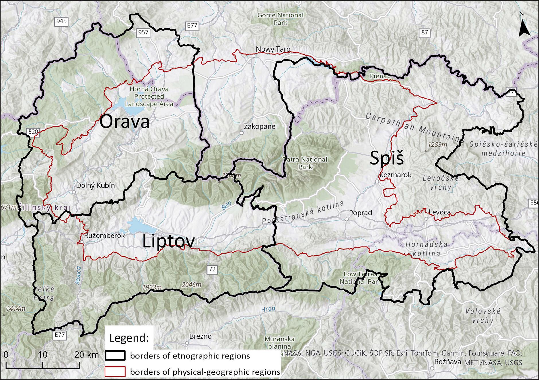
Location of Sub-Tatra region (based on the administrative map of Slovakia available online at www.geoportal.sk).
From the physical-geographical point of view (Mazúr, Lukniš 1978, Balon et al. 2015), this region includes the mountain ranges (Tatra Mountains, Kozie chrbty Mountains, Chočské vrchy Mountains) and interior mountain basins (Podtatranská kotlina Basin, Hornádská kotlina Basin) of the Fatra-Tatra Area within the Inner Western Carpathians, as well as the units of the Podhale-Magura Area (Podtatranská brázda Trench, Skorušinské vrchy Mountains (continued within Poland as the Pogórza Przedtatrzańskie Mountains), Oravská kotlina Basin (continued within Poland as the Kotlina Orawsko-Nowotarska Basin), Spišská Magura Mountains (also extend into Poland as the Magura Spiska Mountains)), the Central section of the Western Beskids (Oravská vrchovina Mountains, Oravská Magura Mountains) and the Eastern section of the Western Beskids (Pieniny Mountains) within the Outer Western Carpathians (Fig. 2).
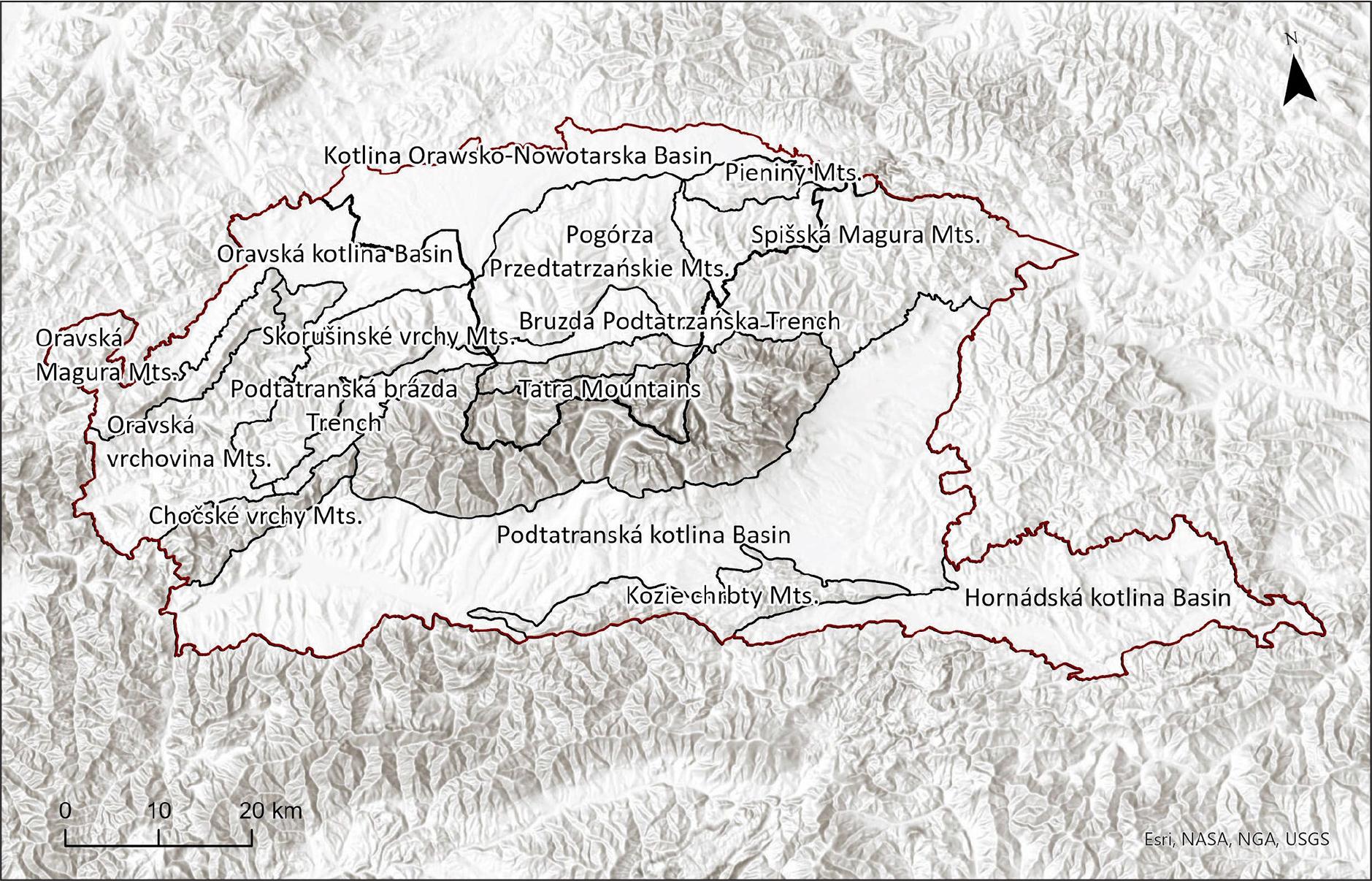
The physical-geographical mesoregions of the study area (based on Urbánek et al. 2009 and Balon et al. 2015).
In the varied geological structure of the territory (e.g. Bezák et al. 2008), several basic units of the Western Carpathians are represented, from the Tatric units (mainly Palaeozoic crystalline core – granites, granodiorites, metamorphites) and the Sub-Tatric Mesozoic nappes (Fatrikum, Hronikum – limestones, dolomites, marls), through the layers of the Inner Carpathian Palaeogene (sandstones, claystones, siltstones), up to the Mesozoic (limestones, marls) units of the Pieniny Klippen Belt and the flysch formations (Palaeogene – sandstones, claystones). The youngest units are the Neogene filling of the Oravská kotlina Basin (clays, dusts, coals, sands, gravels) and Quaternary sediments (fluvial, glacial, glacifluvial). Travertines are a special example of Quaternary rocks that are very numerous. They are formed by chemical precipitation from mineral springs, and their occurrence is mainly linked to the tectonic lines bordering the Podtatranská kotlina Basin and the Hornádská kotlina Basin (Fig. 3).

The geology of the studied area (based on the geological map of lexa et al. 2000).
The nature of the relief in the region under study varies in accordance with the varied geological structure (e.g. Lukniš 1972, Lehotský, Boltižiar 2022). The basic geomorphological units have been individualised as a result of neotectonic movements (e.g. Minár et al. 2011). The highest elevated mountain ranges (Tatra Mountains, Nízke Tatry Mountains) were shaped by mountain glaciers in the Pleistocene, and many fossil forms of glacial relief (glacial valleys, glacial cirques, glacial lakes) can be found there (e.g. Lukniš 1973). Their present-day rocky and mountainous relief is the result of a combination of frost weathering processes and gravitational processes in the periglacial morphoclimatic zone and different geological structures (e.g. Boltižiar 2022). Karst relief on limestones and dolomites (caves, abysses, rock formations) is a special phenomenon. Fluvial and slope processes dominate in the lower mountain ranges, with the flysch mountains in particular being significantly affected by the occurrence of landslides.
From the hydrological point of view, the study area is located on the Main European watershed. It converges southwards via the Váh River to the Danube River and the Black Sea, and northwards via the Dunajec River to the Vistula River and the Baltic Sea. The most important tributaries of the Váh River within the study area are the Orava River and the Belá River, while the tributaries of the Dunajec River include the Poprad River and the Białka River. Most of the lakes are located in the Tatra Mountains and are of glacial origin. In the Spišská Magura Mountains, we can find several smaller landslide-dammed lakes (Fig. 4).
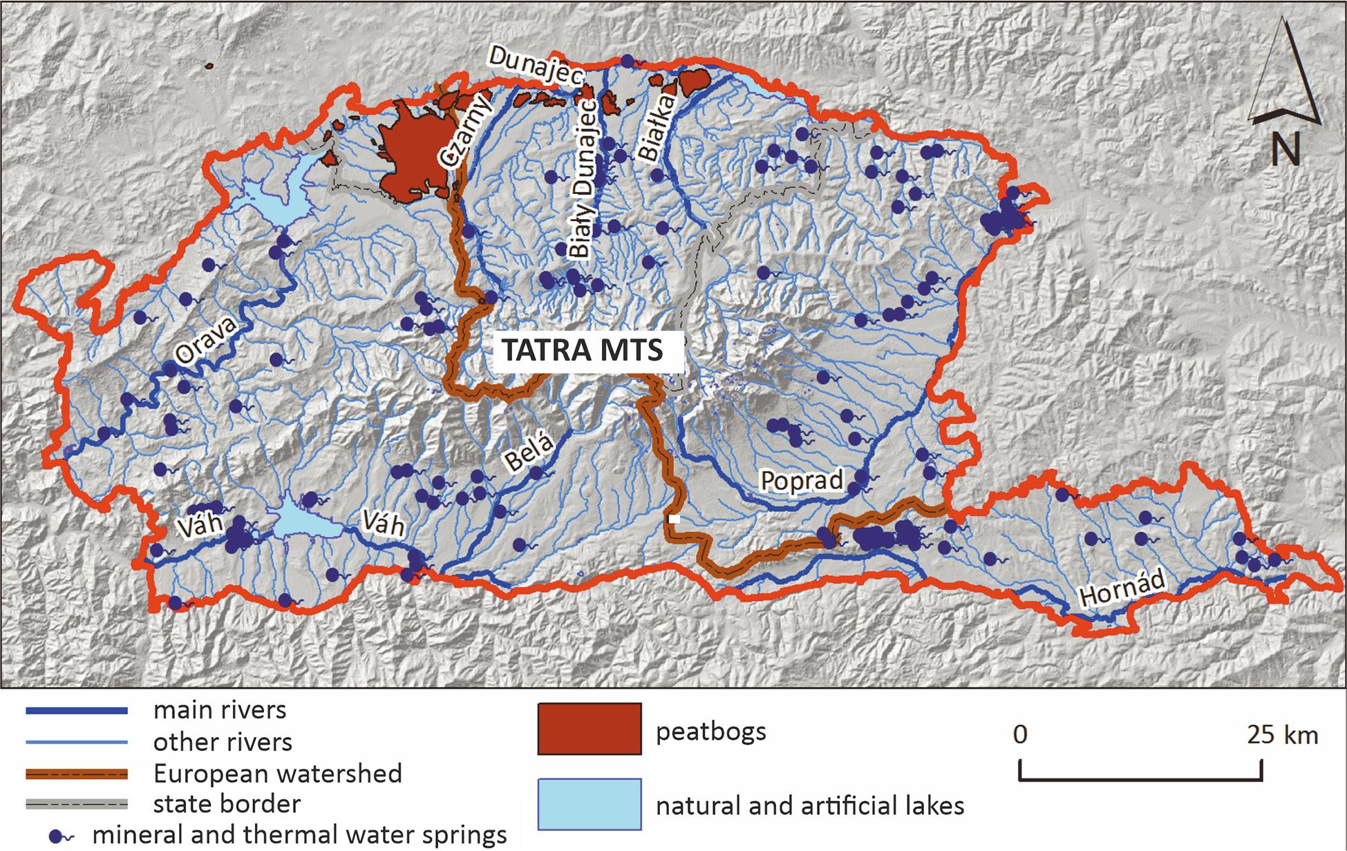
Hydrology of the study area (based on the hydrological map of Turbek (1980), the hydrogeological maps of Chowaniec and Witek (1997a, b), Skąpski and Garbacz (1997), Małecka et al. (2002a, b), and the map of the hydrographic division of Poland available online at www.kzgw.gov.pl.
In the study area, 44 geosites were inventoried and then subjected to valorisation (Fig. 5). They were finally selected through several steps. First, a library search was conducted, consisting of a review of both scientific and popular science literature describing the Sub-Tatra region in search of descriptions of geographically interesting places. Here, guides to conference field sessions (e.g., Gradziński, Mrozińska-Broda 2004, Gradziński et al. 2015) proved very useful. The next step was to identify these objects in the field and check their availability and the possibility of observing forms and explaining the phenomena that led to their creation. Finally, from over 200 inventoried geosites in the entire Sub-Tatra region (on both the Slovak and Polish sides), the 44 best preserved objects in Slovakia were selected and subjected to expert valuation. These consist of rock outcrops, including travertines and quarries, viewpoints, peat bogs, lakes, fragments of river valleys, waterfalls, caves, springs, landslides, and the ruins of buildings related to the local culture and built using local rock materials. Full descriptions of all geosites have been published (Chrobak, Bąk 2019), while their most important features have been published online (Chrobak-Žuffová et al. 2025) as asupplementary file to this article.

Locations of geosites.
The cognitive and educational assessment of the geosites was performed by three experts by the principles of expert triangulation. According to Expert 1, the best-rated geosites in terms of cognitive and educational value are the Červená skala outcrop, the Oravské hradné bralo outcrop, the Pucovské zlepence outcrop, the Lúčanské travertíny outcrop, the Lúčanský vodopád waterfall, the Bešeňovské travertíny outcrop, the Liskovská jaskyňa Cave, the Vavrišovo landslide, the Gánovské travertíny outcrop, the Spišský hradný vrch outcrop, the Dreveník outcrop, the Smrtná jama crater, and the Ružbašské travertíny outcrop. They were included in the first group of geosites with exceptional cognitive and educational value (Table 3). The lowest scores were given to the Jasenová outcrop and the Výhľad na Kozie chrbty viewpoint. These are objects in the last group (group IV) of geosites with low cognitive and educational value (Table 3).
Assessment of geosites according to cognitive and educational criteria.
| No. | Name of the geosite | Expert 1 | Expert 2 | Expert 3 | Expert triangulation | ||||||||
|---|---|---|---|---|---|---|---|---|---|---|---|---|---|
| Sum | Warszyńska indicator | Group | Sum | Warszyńska indicator | Group | Sum | Warszyńska indicator | Group | Average | Warszyńska indicatior | Group | ||
| 1 | Rašelinisko Przybojec/Rudné Peatbog | 47.6 | 0.68 | II | 35.8 | 0.51 | II | 51.8 | 0.74 | I | 45.07 | 0.64 | II |
| 2 | Viewpoint over the Oravská kotlina Basin and Tatra Mountains | 29.2 | 0.42 | II | 34.2 | 0.49 | II | 30.0 | 0.43 | II | 31.13 | 0.44 | II |
| 3 | Čimhovské vrstvy layers | 27.5 | 0.39 | III | 42.5 | 0.61 | II | 27.5 | 0.39 | III | 32.50 | 0.46 | II |
| 4 | Oravská priehrada Dam viewpoint | 40.0 | 0.57 | II | 56.7 | 0.81 | I | 38.3 | 0.55 | II | 45.00 | 0.64 | II |
| 5 | Halečková outcrop | 23.4 | 0.33 | III | 15.8 | 0.23 | III | 23.4 | 0.33 | III | 20.87 | 0.30 | III |
| 6 | Oravice outcrop | 17.5 | 0.25 | III | 20.8 | 0.30 | III | 17.5 | 0.25 | III | 18.60 | 0.27 | III |
| 7 | Červená skala outcrop | 56.7 | 0.81 | I | 45.8 | 0.65 | II | 60.9 | 0.87 | I | 54.47 | 0.78 | I |
| 8 | Františkova huta ironworks | 22.5 | 0.32 | III | 40.0 | 0.57 | II | 25.0 | 0.36 | III | 29.17 | 0.42 | II |
| 9 | Biela skala outcrop | 42.5 | 0.61 | II | 27.5 | 0.39 | III | 43.4 | 0.62 | II | 37.80 | 0.54 | II |
| 10 | Oravské hradné bralo outcrop | 57.5 | 0.82 | I | 56.6 | 0.81 | I | 64.2 | 0.92 | I | 59.43 | 0.85 | I |
| 11 | Pucovské zlepence outcrop | 54.2 | 0.77 | I | 42.5 | 0.61 | II | 56.7 | 0.81 | I | 51.13 | 0.73 | I |
| 12 | Ostrá skala a Tupá skala outcrop | 41.7 | 0.60 | II | 37.4 | 0.53 | II | 45.9 | 0.66 | II | 41.67 | 0.60 | II |
| 13 | Jasenová outcrop | 7.5 | 0.11 | IV | 15.8 | 0.23 | III | 8.3 | 0.12 | IV | 10.53 | 0.15 | IV |
| 14 | Hutianske súvrstvie outcrop | 24.1 | 0.34 | III | 30.8 | 0.44 | II | 22.5 | 0.32 | III | 25.80 | 0.37 | III |
| 15 | Kvačianska dolina Valley | 41.6 | 0.59 | II | 45.9 | 0.66 | II | 20.0 | 0.29 | III | 35.83 | 0.51 | II |
| 16 | Prosiecka dolina Valley | 40.0 | 0.57 | II | 35.9 | 0.51 | II | 28.3 | 0.40 | II | 34.73 | 0.50 | II |
| 17 | Viewpoint from the Veľký Choč Mt. | 33.3 | 0.48 | II | 52.5 | 0.75 | I | 23.3 | 0.33 | III | 36.37 | 0.52 | II |
| 18 | Lúčanské travertíny outcrop | 50.9 | 0.73 | I | 31.7 | 0.45 | II | 18.3 | 0.26 | III | 33.63 | 0.48 | II |
| 19 | Lúčanský vodopád waterfall | 57.6 | 0.82 | I | 31.7 | 0.45 | II | 31.7 | 0.45 | II | 40.33 | 0.58 | II |
| 20 | Bešeňovské travertíny outcrop | 54.3 | 0.78 | I | 43.3 | 0.62 | II | 25.0 | 0.36 | III | 40.87 | 0.58 | II |
| 21 | Viewpoint of the Liptovská Mara Dam | 22.5 | 0.32 | III | 36.6 | 0.52 | II | 20.0 | 0.29 | III | 26.37 | 0.38 | III |
| 22 | Liskovská jaskyňa Cave | 55.1 | 0.79 | I | 35.0 | 0.50 | II | 15.0 | 0.21 | III | 35.03 | 0.50 | II |
| 23 | Skalná (Jánošíkova) päsť outcrop | 32.6 | 0.47 | II | 13.3 | 0.19 | IV | 13.3 | 0.19 | IV | 19.73 | 0.28 | III |
| 24 | Sliačske travertíny outcrop | 38.4 | 0.55 | II | 36.6 | 0.52 | II | 11.6 | 0.17 | IV | 28.87 | 0.41 | II |
| 25 | Termálny prameň Kaďa spring | 30.9 | 0.44 | II | 16.7 | 0.24 | III | 25.0 | 0.36 | III | 24.20 | 0.35 | III |
| 26 | Velínok outcrop | 27.5 | 0.39 | III | 38.4 | 0.55 | II | 47.5 | 0.68 | II | 37.80 | 0.54 | II |
| 27 | Belá and Váh riverbed | 40.0 | 0.57 | II | 44.1 | 0.63 | II | 33.4 | 0.48 | II | 39.17 | 0.56 | II |
| 28 | Liptovský Hrádok outcrop | 30.9 | 0.44 | II | 9.9 | 0.14 | IV | 40.0 | 0.57 | II | 26.93 | 0.38 | III |
| 29 | Vavrišovo landslide | 55.0 | 0.79 | I | 35.0 | 0.50 | II | 13.4 | 0.19 | IV | 34.47 | 0.49 | II |
| 30 | Hybická tiesňava gorge | 47.6 | 0.68 | II | 16.6 | 0.24 | III | 23.4 | 0.33 | III | 29.20 | 0.42 | II |
| 31 | Kvetnica outcrop | 44.1 | 0.63 | II | 32.5 | 0.46 | II | 42.5 | 0.61 | II | 39.70 | 0.57 | II |
| 32 | Kozie chrbty viewpoint | 13.3 | 0.19 | IV | 45.0 | 0.64 | II | 28.3 | 0.40 | II | 28.87 | 0.41 | II |
| 33 | Gánovské travertíny outcrop | 63.4 | 0.91 | I | 29.1 | 0.42 | II | 64.2 | 0.92 | I | 52.23 | 0.75 | I |
| 34 | Gánovské slaniská springs | 40.0 | 0.57 | II | 45.8 | 0.65 | II | 52.5 | 0.75 | I | 46.10 | 0.66 | II |
| 35 | Ondrej mineral spring | 32.5 | 0.46 | II | 20.7 | 0.30 | III | 47.6 | 0.68 | II | 33.60 | 0.48 | II |
| 36 | Sivá brada outcrop | 30.0 | 0.43 | II | 58.4 | 0.83 | I | 50.0 | 0.71 | I | 46.13 | 0.66 | II |
| 37 | Spišský hradný vrch outcrop | 57.5 | 0.82 | I | 39.9 | 0.57 | II | 67.5 | 0.96 | I | 54.97 | 0.79 | I |
| 38 | Dreveník outcrop | 64.2 | 0.92 | I | 54.1 | 0.77 | I | 67.5 | 0.96 | I | 61.93 | 0.88 | I |
| 39 | Kežmarské vrstvy outcrop | 32.4 | 0.46 | II | 44.2 | 0.63 | II | 30.8 | 0.44 | II | 35.80 | 0.51 | II |
| 40 | Strednica viewpoint | 42.5 | 0.61 | II | 62.5 | 0.89 | I | 58.3 | 0.83 | I | 54.43 | 0.78 | I |
| 41 | Bachledova dolina outcrop | 31.6 | 0.45 | II | 34.2 | 0.49 | II | 35.8 | 0.51 | II | 33.87 | 0.48 | II |
| 42 | Jezersko Lake | 34.2 | 0.49 | II | 39.2 | 0.56 | II | 59.2 | 0.85 | I | 44.20 | 0.63 | II |
| 43 | Smrtná jama outcrop | 60.9 | 0.87 | I | 30.0 | 0.43 | II | 45.9 | 0.66 | II | 45.60 | 0.65 | II |
| 44 | Ružbašské travertíny outcrop | 55.0 | 0.79 | I | 39.2 | 0.56 | II | 66.7 | 0.95 | I | 53.63 | 0.77 | I |
According to Expert 2, the best assessed geosites in terms of cognitive and educational value are the Oravská priehrada viewpoint, the Oravské hradné bralo outcrop, the Veľký Choč viewpoint, the Sivá brada outcrop, the Dreveník outcrop and the Strednica viewpoint; they are in the first group of geosites with exceptional cognitive and educational value (Table 3). The lowest assessed geosites were the Liptovský Hrádok outcrop and the Skalná (Jánošíkova) päs’ outcrop. They are in group IV, which contains geosites with low cognitive and educational value (Table 3).
According to Expert 3, the best-rated geosites in terms of cognitive and educational value are the Sivá brada outcrop, the Rašelinisko Przybojec/Rudné peatbog, the Gánovské slaniská outcrop, the Pucovské zlepence outcrop, the Strednica viewpoint, Jezersko Lake, the Červená skala outcrop, the Oravské hradné bralo outcrop, the Gánovské travertíny outcrop, the Ružbašské travertíny outcrop, the Spišský hradný vrch outcrop, and the Dreveník outcrop. They were included in the first group of geosites with exceptional cognitive and educational value (Table 3). The lowest rated geosites were the Jasenová outcrop, the Sliačske travertíny outcrop, the Skalná (Jánošíkova) päsť outcrop, and the Vavrišovo landslide. These are objects in the last group (group IV) of geosites with low cognitive and educational value (Table 3). From the expert triangulation, the best-rated geosites are the Pucovské zlepence outcrop, the Gánovské travertíny outcrop, the Ružbašské travertíny outcrop, the Strednica viewpoint, the Červená skala outcrop, the Spišský hradný vrch outcrop, the Oravské hradné bralo outcrop, and the Dreveník outcrop. They were placed in the first group of geosites with exceptional cognitive and educational value (Table 3). The Jasenová outcrop was rated the worst. It is an object in the last group (group IV) of geosites with low cognitive and educational value (Table 3).
The experts were more unanimous in their assessment of the representativeness of geological, hydrogeological, hydrological, and relief-forming processes and their educational value, as well as in assessing the degree of landscape diversity and degree of degradation (destruction) of the site. On the contrary, a lower level of agreement in the evaluation was reached in terms of the uniqueness of each site compared to other similar sites in Slovakia and the uniqueness of each site in relation to the Sub-Tatra region, as well as from the point of view of the scientific value of each site expressed in scientific publications and other features related to abiotic nature near each site.
In terms of the geosite type, in the overall assessment, the experts differed the most in the assessment of caves, and there were also relatively large differences in the assessment of landslides and waterfalls. On the contrary, the expert assessments differed the least for rock outcrops and peatlands.
In terms of the assessment of the uniqueness of each site in relation to the Sub-Tatra region, the experts differed the most in the assessment of peatlands and the least in the assessment of sites associated with the history of mining and metallurgy, springs, and waterfalls. Conversely, when assessing the degree of degradation, the assessments of the sites associated with the history of mining and metallurgy diverged the most (the assessments of the travertines and viewpoints diverged the least). In the assessment of the representativeness of geological, hydrogeological, hydrological, and relief-forming processes and their educational value, the differences were largest for landslides and smallest for caves and waterfalls. When assessing the degree of landscape diversity, in turn, the differences were greatest in the case of caves (along with landslides), and the lowest differences again occurred in the assessment of sites with a waterfall. For other features related to abiotic nature in the immediate vicinity of each site, the assessments of peat lands and waterfalls differed the most, with the smallest differences in the assessment of sites associated with the history of mining and metallurgy. There was also a large dispersion in the assessment of the waterfalls in terms of the scientific value of each site expressed in scientific publications (the smallest differences were found in the assessment of the rock outcrops). Finally, in terms of evaluating the uniqueness of each site compared to other similar sites in Slovakia, the opinions of experts differed most for sites associated with the history of mining and metallurgy and least for springs, peatlands and rock outcrops (Fig. 6).

Expert assessment agreement level. A – Agreement level within each evaluation category. B – Agreement level for the different types of geosites. REGION – The uniqueness of the site in relation to the Sub-Tatra region, DEGRADATION – The degree of degradation (destruction) of the site, REPRESENT – The representativeness of geological, hydrogeological, hydrological and relief-forming processes and their educational value, DIVERSITY – The degree of landscape diversity, OTHER – Other features related to abiotic nature in the immediate vicinity of the site, SCIENCE – The scientific value of the site expressed in scientific publications, SlOVAKIA – The uniqueness of the site compared to other similar sites in Slovakia.
Geosites were assessed for tourism value based on previously conducted analyses of distance and accessibility (Chrobak, Bąk 2019).The best assessed geosites in terms of the tourism criteria are the Oravské hradné bralo outcrop, the Strednica viewpoint, the Termálny prameň Kaďa spring, the Spišský hradný vrch outcrop and the liptovský Hrádok outcrop. They were classified into the first group of sites with special tourist value. The worst assessed geosite in terms of the tourism criteria is the Hybická tiesňava gorge. It is the only geosite in group IV, consisting of geosites with low tourist value (Table 4).
Assessment of geosites in terms of tourist criteria.
| No. | Name of the geosite | Scenic values | Width of the viewing angle from the point of view | Accessibility of the site | Current form of accessibility as a tourist attraction | Legal protection status of geosite | Equipment and additional services (gastronomy, souvenir shops) | Presence of other tourist attractions | Sum | Warszyńska indicator | Group |
|---|---|---|---|---|---|---|---|---|---|---|---|
| 10 | Oravské hradné bralo outcrop | 8 | 10.0 | 8 | 10.0 | 6.7 | 7.5 | 10.0 | 60.2 | 0.86 | I |
| 40 | Strednica viewpoint | 10 | 2.5 | 10 | 10.0 | 6.7 | 5.0 | 10.0 | 54.2 | 0.77 | I |
| 25 | Termálny prameň Kad’a spring | 8 | 2.5 | 10 | 10.0 | 3.3 | 7.5 | 10.0 | 51.3 | 0.73 | I |
| 37 | Spišský hradný vrch outcrop | 8 | 10.0 | 8 | 10.0 | 0.0 | 5.0 | 10.0 | 51.0 | 0.73 | I |
| 28 | Liptovský Hrádok outcrop | 6 | 5.0 | 10 | 10.0 | 6.7 | 5.0 | 7.5 | 50.2 | 0.72 | I |
| 19 | Lúčanský vodopád waterfall | 10 | 2.5 | 10 | 10.0 | 3.3 | 7.5 | 5.0 | 48.3 | 0.69 | II |
| 21 | Viewpoint of the Liptovská Mara Dam | 6 | 7.5 | 8 | 10.0 | 6.7 | 2.5 | 7.5 | 48.2 | 0.69 | II |
| 44 | Ružbašské travertíny outcrop | 10 | 2.5 | 8 | 10.0 | 0.0 | 7.5 | 7.5 | 45.5 | 0.65 | II |
| 7 | Červená skala outcrop | 8 | 5.0 | 6 | 6.7 | 6.7 | 7.5 | 5.0 | 44.9 | 0.64 | II |
| 36 | Sivá brada outcrop | 10 | 7.5 | 8 | 10.0 | 0.0 | 2.5 | 5.0 | 43.0 | 0.61 | II |
| 16 | Prosiecka dolina Valley | 6 | 10.0 | 6 | 10.0 | 3.3 | 2.5 | 5.0 | 42.8 | 0.61 | II |
| 8 | Františkova huta ironworks | 8 | 2.5 | 8 | 10.0 | 6.7 | 2.5 | 5.0 | 42.7 | 0.61 | II |
| 4 | Oravská priehrada Dam viewpoint | 6 | 2.5 | 2 | 10.0 | 6.7 | 5.0 | 10.0 | 42.2 | 0.60 | II |
| 38 | Dreveník outcrop | 6 | 10.0 | 8 | 10.0 | 0.0 | 2.5 | 5.0 | 41.5 | 0.59 | II |
| 26 | Velínok outcrop | 10 | 2.5 | 8 | 3.3 | 6.7 | 5.0 | 5.0 | 40.5 | 0.58 | II |
| 17 | Viewpoint from the Veľký Choč Mt. | 10 | 10.0 | 2 | 10.0 | 3.3 | 2.5 | 2.5 | 40.3 | 0.58 | II |
| 6 | Oravice outcrop | 8 | 2.5 | 8 | 0.0 | 6.7 | 7.5 | 7.5 | 40.2 | 0.57 | II |
| 33 | Gánovské travertíny outcrop | 10 | 5.0 | 10 | 10.0 | 0.0 | 2.5 | 2.5 | 40.0 | 0.57 | II |
| 15 | Kvačianska dolina Valley | 10 | 2.5 | 4 | 10.0 | 3.3 | 5.0 | 5.0 | 39.8 | 0.57 | II |
| 2 | Viewpoint over the Oravská kotlina Basin and Tatra Moutnains | 8 | 2.5 | 4 | 10.0 | 6.7 | 5.0 | 2.5 | 38.7 | 0.55 | II |
| 9 | Biela skala outcrop | 8 | 5.0 | 8 | 0.0 | 6.7 | 5.0 | 5.0 | 37.7 | 0.54 | II |
| 18 | Lúčanské travertíny outcrop | 8 | 2.5 | 8 | 0.0 | 6.7 | 7.5 | 5.0 | 37.7 | 0.54 | II |
| 13 | Jasenová outcrop | 8 | 2.5 | 10 | 0.0 | 6.7 | 7.5 | 2.5 | 37.2 | 0.53 | II |
| 42 | Jezersko Lake | 6 | 5.0 | 2 | 10.0 | 6.7 | 2.5 | 5.0 | 37.2 | 0.53 | II |
| 5 | Halečková outcrop | 6 | 2.5 | 8 | 0.0 | 6.7 | 5.0 | 7.5 | 35.7 | 0.51 | II |
| 14 | Hutianske súvrstvie outcrop | 8 | 2.5 | 8 | 0.0 | 6.7 | 5.0 | 5.0 | 35.2 | 0.50 | II |
| 39 | Kežmarské vrstvy outcrop | 8 | 2.5 | 8 | 0.0 | 6.7 | 5.0 | 5.0 | 35.2 | 0.50 | II |
| 41 | Bachledova dolina outcrop | 8 | 2.5 | 8 | 0.0 | 6.7 | 2.5 | 7.5 | 35.2 | 0.50 | II |
| 43 | Smrtná jama outcrop | 4 | 2.5 | 8 | 0.0 | 3.3 | 7.5 | 7.5 | 32.8 | 0.47 | II |
| 24 | Sliačske travertíny outcrop | 8 | 2.5 | 8 | 3.3 | 0.0 | 5.0 | 5.0 | 31.8 | 0.45 | II |
| 20 | Bešeňovské travertíny outcrop | 6 | 2.5 | 6 | 6.7 | 0.0 | 5.0 | 5.0 | 31.2 | 0.45 | II |
| 27 | Belá and Váh riverbed | 6 | 2.5 | 6 | 0.0 | 6.7 | 7.5 | 2.5 | 31.2 | 0.45 | II |
| 29 | Vavrišovo landslide | 6 | 2.5 | 8 | 0.0 | 6.7 | 5.0 | 2.5 | 30.7 | 0.44 | II |
| 31 | Kvetnica outcrop | 8 | 2.5 | 8 | 0.0 | 6.7 | 2.5 | 2.5 | 30.2 | 0.43 | II |
| 11 | Pucovské zlepence outcrop | 8 | 2.5 | 8 | 0.0 | 3.3 | 5.0 | 2.5 | 29.3 | 0.42 | II |
| 12 | Ostrá skala a Tupá skala outcrop | 6 | 5.0 | 4 | 0.0 | 6.7 | 5.0 | 2.5 | 29.2 | 0.42 | II |
| 3 | Čimhovské vrstvy layers | 6 | 2.5 | 6 | 0.0 | 6.7 | 5.0 | 2.5 | 28.7 | 0.41 | II |
| 34 | Gánovské slaniská springs | 10 | 2.5 | 4 | 0.0 | 6.7 | 2.5 | 2.5 | 28.2 | 0.40 | II |
| 23 | Skalná (Jánošíkova) päsť outcrop | 8 | 2.5 | 8 | 0.0 | 0.0 | 5.0 | 2.5 | 26.0 | 0.37 | III |
| 35 | Ondrej mineral spring | 8 | 2.5 | 8 | 0.0 | 0.0 | 5.0 | 2.5 | 26.0 | 0.37 | III |
| 32 | Kozie chrbty viewpoint | 6 | 5.0 | 2 | 0.0 | 6.7 | 2.5 | 2.5 | 24.7 | 0.35 | III |
| 22 | Liskovská jaskyňa Cave | 6 | 2.5 | 8 | 0.0 | 0.0 | 5.0 | 2.5 | 24.0 | 0.34 | III |
| 1 | Rašelinisko Przybojec/Rudné Peatbog | 6 | 2.5 | 2 | 0.0 | 3.3 | 2.5 | 2.5 | 18.8 | 0.27 | III |
| 30 | Hybická tiesňava gorge | 4 | 2.5 | 2 | 0.0 | 0.0 | 2.5 | 0.0 | 11.0 | 0.16 | IV |
The best assessed geosites in terms of general valorisation are the Oravské hradné bralo outcrop, Dreveník outcrop, Strednica viewpoint, Spišský hradný vrch outcrop, Červená skala outcrop and Ružbašské travertíny outcrop. The lowest rated geosite is the Jasenová outcrop (Table 5).
Final assessment of geosites.
| No. | Name of the geosite | Average | Warszyńska indicatior | Group | Sum | Warszyńska indicator | Group | Total Assessment | Warszyńska indicator | Group |
|---|---|---|---|---|---|---|---|---|---|---|
| 10 | Oravské hradné bralo | 59.43 | 0.85 | I | 60.20 | 0.86 | I | 59.66 | 0.85 | I |
| 38 | Dreveník | 61.93 | 0.88 | I | 41.50 | 0.59 | II | 55.80 | 0.80 | I |
| 40 | Strednica | 54.43 | 0.78 | I | 54.20 | 0.77 | I | 54.36 | 0.78 | I |
| 37 | Spišský hradný vrch | 54.97 | 0.79 | I | 51.00 | 0.73 | I | 53.78 | 0.77 | I |
| 7 | Červená skala | 54.47 | 0.78 | I | 44.90 | 0.64 | II | 51.60 | 0.74 | I |
| 44 | Ružbašské travertíny | 53.63 | 0.77 | I | 45.50 | 0.65 | II | 51.19 | 0.73 | I |
| 33 | Gánovské travertíny | 52.23 | 0.75 | I | 40.00 | 0.57 | II | 48.56 | 0.69 | II |
| 36 | Sivá brada | 46.13 | 0.66 | II | 43.00 | 0.61 | II | 45.19 | 0.65 | II |
| 11 | Pucovské zlepence | 51.13 | 0.73 | I | 29.30 | 0.42 | II | 44.58 | 0.64 | II |
| 4 | Oravská priehrada | 45.00 | 0.64 | II | 42.20 | 0.60 | II | 44.16 | 0.63 | II |
| 19 | Lúčanský vodopád | 40.33 | 0.58 | II | 48.30 | 0.69 | II | 42.72 | 0.61 | II |
| 42 | Jezersko | 44.20 | 0.63 | II | 37.20 | 0.53 | II | 42.10 | 0.60 | II |
| 43 | Smrtná | 45.60 | 0.65 | II | 32.80 | 0.47 | II | 41.76 | 0.60 | II |
| 34 | Gánovské slaniská | 46.10 | 0.66 | II | 28.20 | 0.40 | II | 40.73 | 0.58 | II |
| 26 | Velínok | 37.80 | 0.54 | II | 40.50 | 0.58 | II | 38.61 | 0.55 | II |
| 20 | Bešeňovské travertíny | 40.87 | 0.58 | II | 31.20 | 0.45 | II | 37.97 | 0.54 | II |
| 12 | Ostrá skala a Tupá skala | 41.67 | 0.60 | II | 29.20 | 0.42 | II | 37.93 | 0.54 | II |
| 9 | Biela skala | 37.80 | 0.54 | II | 37.70 | 0.54 | II | 37.77 | 0.54 | II |
| 17 | Veľký Choč | 36.37 | 0.52 | II | 40.30 | 0.58 | II | 37.55 | 0.54 | II |
| 1 | Rašelinisko Przybojec/Rudné | 45.07 | 0.64 | II | 18.80 | 0.27 | III | 37.19 | 0.53 | II |
| 16 | Prosiecka dolina | 34.73 | 0.50 | II | 42.80 | 0.61 | II | 37.15 | 0.53 | II |
| 15 | Kvačianska dolina | 35.83 | 0.51 | II | 39.80 | 0.57 | II | 37.02 | 0.53 | II |
| 31 | Kvetnica | 39.70 | 0.57 | II | 30.20 | 0.43 | II | 36.85 | 0.53 | II |
| 27 | Ústie Belej do Váhu | 39.17 | 0.56 | II | 31.20 | 0.45 | II | 36.78 | 0.53 | II |
| 39 | Kežmarské vrstvy | 35.80 | 0.51 | II | 35.20 | 0.50 | II | 35.62 | 0.51 | II |
| 18 | Lúčanské travertíny | 33.63 | 0.48 | II | 37.70 | 0.54 | II | 34.85 | 0.50 | II |
| 41 | Bachledova dolina | 33.87 | 0.48 | II | 35.20 | 0.50 | II | 34.27 | 0.49 | II |
| 28 | Liptovský Hrádok | 26.93 | 0.38 | III | 50.20 | 0.72 | I | 33.91 | 0.48 | II |
| 2 | Výhľad na Oravskú kotlinu a Tatry | 31.13 | 0.44 | II | 38.70 | 0.55 | II | 33.40 | 0.48 | II |
| 29 | Vavrišovo | 34.47 | 0.49 | II | 30.70 | 0.44 | II | 33.34 | 0.48 | II |
| 8 | Františkova huta | 29.17 | 0.42 | II | 42.70 | 0.61 | II | 33.23 | 0.47 | II |
| 21 | Liptovská Mara | 26.37 | 0.38 | III | 48.20 | 0.69 | II | 32.92 | 0.47 | II |
| 25 | Termálny prameň Kad’a | 24.20 | 0.35 | III | 51.30 | 0.73 | I | 32.33 | 0.46 | II |
| 22 | Liskovská jaskyňa | 35.03 | 0.50 | II | 24.00 | 0.34 | III | 31.72 | 0.45 | II |
| 3 | Čimhovské vrstvy | 32.50 | 0.46 | II | 28.70 | 0.41 | II | 31.36 | 0.45 | II |
| 35 | Minerálny prameň Ondrej | 33.60 | 0.48 | II | 26.00 | 0.37 | III | 31.32 | 0.45 | II |
| 24 | Sliačske travertíny | 28.87 | 0.41 | II | 31.80 | 0.45 | II | 29.75 | 0.42 | II |
| 14 | Hutianske súvrstvie | 25.80 | 0.37 | III | 35.20 | 0.50 | II | 28.62 | 0.41 | II |
| 32 | Výhľad na Kozie chrbty | 28.87 | 0.41 | II | 24.70 | 0.35 | III | 27.62 | 0.39 | III |
| 5 | Halečková | 20.87 | 0.30 | III | 35.70 | 0.51 | II | 25.32 | 0.36 | III |
| 6 | Oravice | 18.60 | 0.27 | III | 40.20 | 0.57 | II | 25.08 | 0.36 | III |
| 30 | Hybická tiesňava | 29.20 | 0.42 | II | 11.00 | 0.16 | IV | 23.74 | 0.34 | III |
| 23 | Skalná (Jánošíkova) päsť | 19.73 | 0.28 | III | 26.00 | 0.37 | III | 21.61 | 0.31 | III |
| 13 | Jasenová | 10.53 | 0.15 | IV | 37.20 | 0.53 | II | 18.53 | 0.26 | III |
Geosites with high cognitive and educational value are associated with rocks that rarely occur on the Earth’s surface, such as travertines, and with the possibility of observing how these rocks are formed, as well as with the presence of artefacts in these rocks documenting the history of settlement in this region. This mainly concerns travertines located in Spiš and Liptov.
The dome in the ruins of the Spiš castle contains underground karst forms, and the Drevenik travertine dome is one of the largest in Europe (2 km × 1 km). Travertine craters of varying degrees of activity in Vyšné Ružbachy represent a place of gas exhalation. Carbonate floods formed in the vicinity of active springs in Lúčky, Vyšné Ružbachy and Bešeňová are examples of contemporary processes of calcareous tufa formation, while the dome in Gánovce is one of the most famous archaeological sites in Slovakia. From an educational point of view, the occurrence of travertines in these places can be additionally linked to the presence of mineral springs, and the mineralisation and outflows to the surface of these springs occurred in zones of deep fractures of the geological bedrock (e.g. Vlček 1969, Gross et al. 1999a, b, Mello et al. 2000a, b, Potočná 2007, Gradziński et al. 2008, 2014, Wróblewski et al. 2010, Sabol et al. 2017). The high cognitive and educational value of geosites located in the Pieniny Klippen Belt, which have the character of limestone outcrop rocks (Oravské hradné bralo outcrop – rock with a medieval castle, or Červená skala outcrop – Jurassic rock containing numerous fossils), results from the fact that they are very good places for interpretation: they include features of marine environments, which were recorded in various types of carbonate-siliceous rocks (shell rocks, micritic limestones, nodular limestones, siliceous limestones, radiolarites) and structural features related to the complicated history of the formation of this area. At the opposite end of the valuation coefficients of objects according to cognitive and educational criteria (fourth category of sites) is the exposure of carbonate rocks of a submarine landslide in the village of Jasenová. The low value results from the high degree of destruction of the exposure and, consequently, the incompleteness of the record of rock features that can be observed and used to interpret the environment in which they formed.
Analyses of the distances of geosites from accommodation facilities, road and rail infrastructure and other additional tourist attractions confirm their very good transport accessibility. Most of the facilities are located close to roads and trails, next to which are parking spaces.
The best tourist development of the valorised facilities, expressed by the highest tourist value coefficients, is presented by the limestone rock of the Orava castle, the viewpoint in Ždiar-Strednica, the thermal spring in Liptovský Ján, the travertine dome of the Spiš castle and the Liptovský Hrádok outcrop. They were classified in category I, consisting of facilities distinguished by very good transport accessibility, close proximity to other (additional) tourist facilities or themselves being part of other tourist facilities. In addition, they are widely promoted as tourist facilities, and there is a large amount of accommodation in their vicinity.
On the other side, the least developed geosite, with the lowest tourist value, is the Hybická tiesňava gorge. It is in category IV, which contains geosites that are not listed in any databases (guidebooks) of tourist facilities, and accommodation and other possible tourist attractions are located a large distance away.
The proximity of larger towns for most geosites also guarantees the possibility of using other tourist services, that is accommodation, catering, guide services or additional tourist and recreational attractions, including visiting the monuments of this region, such as cultural monuments, museums or natural monuments (Chrobak, Bąk 2019). An additional tourist advantage of the Sub-Tatra region is its elements of folk culture, such as dialectal phraseology, which was shaped in the conditions of the interpenetration of dialects, languages and cultures.
The ownership structure of the plots on which the geosites are located and the state of their legal protection are conducive to the expansion of tourist infrastructure, as most of them are located in areas with a lower level of protection (active or landscape protection) or no protection.
The characteristics of the physical and geographical elements and tourist assets presented for the 44 assessed geosites indicate that the Sub-Tatra region is characterised by, on the one hand, strong geodiversity, and on the other hand, good tourist development, which is reflected in the high values of the final valuation coefficients, based on which six described sites fall into the highest attractiveness category. At the same time, there are no sites in the lowest category. However, it should be emphasised here that the authors assumed that in the assessment of the final attractiveness of this type of geosite, the weight of the cognitive and educational criteria should be much higher than the weight of the tourist development criteria (WT) (Chrobak, Bąk 2019). For this reason, the values of the educational and cognitive coefficient strongly correlate with the values of the final coefficient (r = 0.94). The highest final valuation coefficients for objects in the Sub-Tatra region showing particularly high geotourist value were obtained by the following geosites: limestone rock of the Oravský hrad castle, the travertine dome Dreveník, the travertine hill of the Spišský hrad castle, limestone rock with Jurassic fossils near the village of Podbiel and contemporary forms of sculpture associated with travertines in Vyšné Ružbachy. There were 32 geosites in category II (high geotourist value). These objects are characterised by high assessments of the main components, or they have one very high and one very low assessment. Six geosites represent objects in category III, that is sites with medium geotourist value. The valuation coefficients for individual components in these groups were medium and low, respectively, or very diverse, with low dominance. Taking into account the unequal weights of the final valuation coefficient components, their values should be considered primarily in the context of the distribution of the educational and cognitive valuation coefficients; this results primarily from the diverse geological structure of the studied area. The largest number of geosites is located at the junction of two or three physical and geographical units, in most cases corresponding to the boundaries of geological units, that is the Podhale Basin with the Pieniny Klippen Belt, the Oravská vrchovina Foothills and the Liptovská kotlina Basin with the Chočské vrchy Mountains, the Malá Fatra Mountains and Veľká Fatra Mountains, and the Tatra Mountains. This results primarily from the contact of different rock series, characterised by varying degrees of resistance to weathering, and also from the proximity of fault zones and related outflows of waters supersaturated with CaCO3. Taking into account the values of the final valuation coefficient, attractive objects in the SubTatra region also include fragments of valleys in the Chočské vrchy Mountains massif (Prosiecka dolina and Kvačianska dolina), waterfalls in Spiš, Liptov and Orava, and caves. They are distinguished on the one hand by morphological diversity, as exemplified by deep ravines with numerous forms of surface and underground karst in the Prosiecka dolina and Kvačianska dolina valleys or fragments of riverbeds with waterfalls of various shapes and origins, as well as by the uniqueness of their occurrence on a supra-regional scale, such as a small cylindrical cave in Lúčky. On the other hand, the distinction of some forms is influenced by the cultural values of the region associated with them, as is the case, for example, in the Liskovská jaskyňa Cave. They are associated with artefacts related to the history of settlement in the Liptov and Spiš regions (e.g. Kollár 1999a, Lacika 1999a). Although the values of the final valuation coefficients for hydrological objects are at an average level (within a wide range of values), many of them have special cognitive and educational significance, because they allow the observation of contemporary natural processes leading to the creation of new forms of relief or changes in the shape of existing relief elements. This applies to fragments of riverbeds and springs, which until now have rarely been the main goal in geotourism, but they could be. Places where it is possible to observe hydrological phenomena include strongly mineralised springs, around which calcium carbonate is precipitated on various surfaces, including herbaceous vegetation. They also include artesian outflows of water under pressure, resulting in a fountain effect. Observation spread over a slightly longer period of time, for example two visits over the course of 1 year, allows the understanding of the scale of changes occurring in mountain stream beds, related to changes in the speed of gravel and sand transport during floods and during periods of hydrological drought. For this group of objects, an additional element of attraction may be the difficult-to-measure aesthetic values of such places, the importance of which may be highly variable, depending on the individual sensitivity of the assessor.
The analysis of the natural characteristics and scientific data of the Sub-Tatra region and verification in the field in terms of assessing the value of abiotic nature showed that this is an area with very high geotourism potential. Based on this and using the valuation method for selected geosites, based on a number of cognitive, educational and tourist criteria, 44 geosites were inventoried. Among them, objects related to various elements of the geological structure, various forms of relief and various hydrological elements predominate, but the places whose locations are related to the occurrence of travertines in the geological substrate stand out. They are located in the area of the Liptovská kotlina Basin, the Kozie chrbty Mountains and the tectonic structure of Ružbachy. The north-western part of the Oravská vrchovina Mountains, where the formations of the Pieniny Klippen Belt and the Chočské vrchy Mountains occur, has equally high geotourism potential. These places themselves can be the main destinations for tourism. These areas have a large lithological diversity of the substrate, a large number of microscale and mesoscale tectonic structures, and diverse, mainly karst, relief. They also include viewpoints, which, through the possibility of observing many types of landscapes, acquire a high educational value, especially in terms of regional aspects related to the observation of the relief of the Tatra Mountains, the Nízke Tatry Mountains and the Tatra Foothills (Skorušinské vrchy Mountains, Spišská Magura Mountains, and Pogórza Przedtatrzańskie Mountains).
The locations of the geosites, most of which are grouped within short distances of each other, in regions with a high degree of geodiversity, make it possible to connect them using roads or tourist trails, which is an additional factor that led to the high geotourism values in the assessment of this region.
The Sub-Tatra region has long traditions related to tourism; this is documented by the results of analyses of various tourist indicators based on data on the number of tourists and accommodation facilities in this region. They indicate that the best-developed administrative units are those that include the Tatra Mountains or the Nízke Tatry Mountains.
The analysis of the geotourism potential of the Sub-Tatra region presented in this work conveys a message to individuals and local government units about the possible additional tourist promotion of various parts of Spiš, Orava and Liptov. The method of promoting the geosites selected in this work could take various forms that are currently used in marketing for this type of tourist product, such as information panels in appropriate places, descriptions of geosites in various types of mobile applications, tourist guides or geological and tourist maps for the Sub-Tatra region. Enriching the tourist offerings of the Sub-Tatra region with geoattractions could, even if only to a small extent, contribute to ‘moving’ some of the tourist traffic out of the crowded Tatra Mountains. This will be influenced primarily by guides, teachers, and organisers of tourist trips.
However, the results of expert assessment represent only part of the assessment of the geotourism potential of this region. These studies will probably be complemented by studies of tourist preferences, which have already been partially done and indicated specific types of geosites as the most attractive ones, that is viewpoints, river gorges and travertine outcrops (Chrobak-Žuffová 2023). The authors of this article plan to conduct further studies and public consultations to be able to select the most attractive geosites possible.