
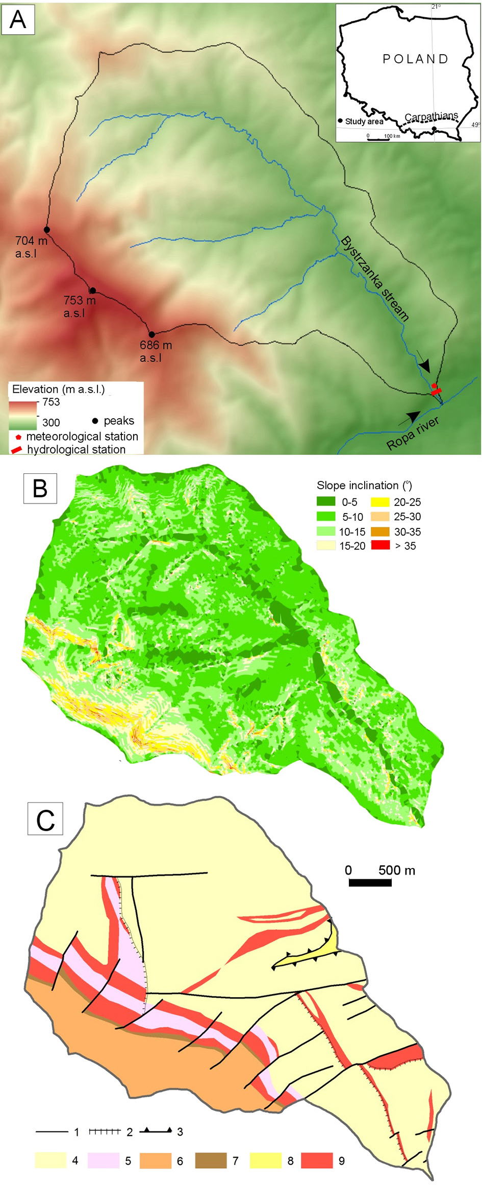
Fig. 1.
A – Location of the study area and environmental characteristics of the Bystrzanka catchment area; B – slope; based on the deM with 10 m resolution; C – geological structure: 1– fault, 2 – minor thrust fault, 3 – major thrust fault, 4 – Inoceramus beds, 5 – Cięzkowickie sandstones, 6 – Magura sandstones, 7 – Sub-Magura sandstones, 8 – Krosno Bed, 9 – variegated shales; based on Wójcik et al. (2003).
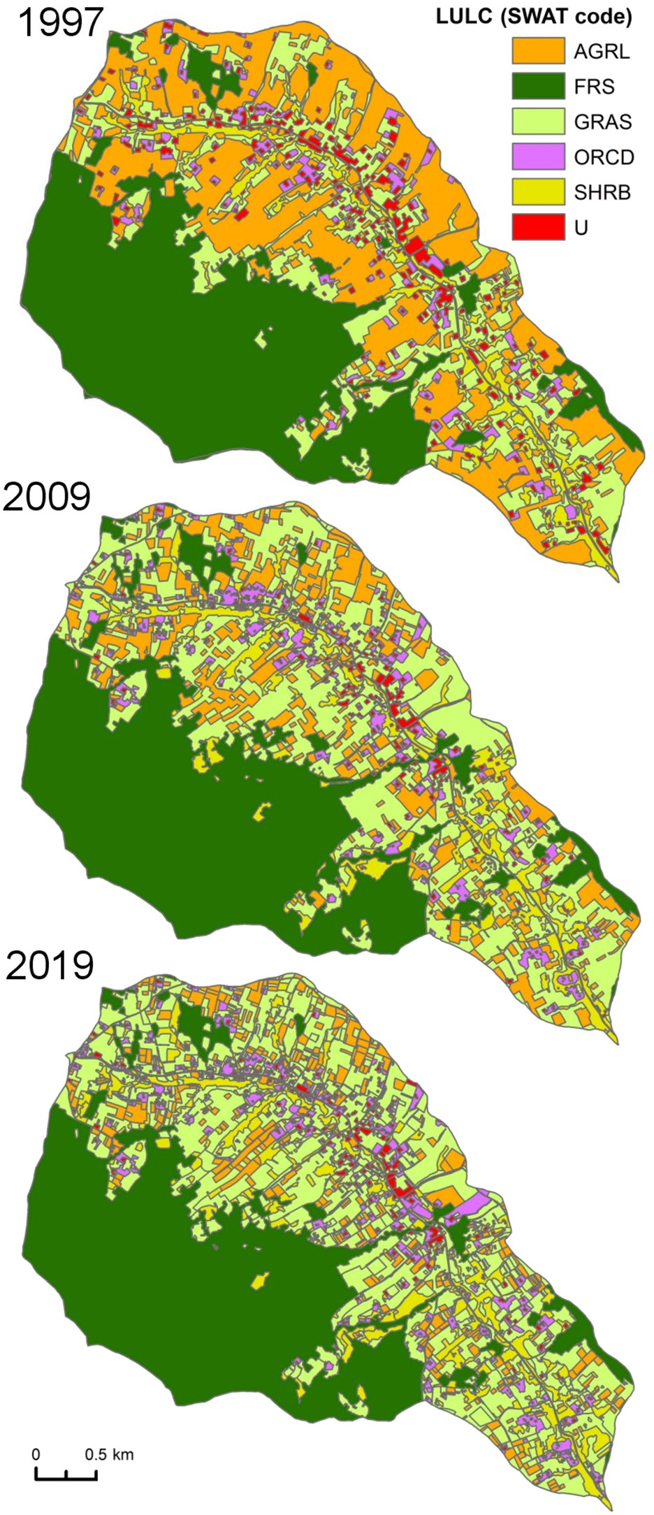
Fig. 2.
Land use an land cover (LULC) changes in Bystrzanka catchment (1 – cultivated land, 2 – forest (deciduous, mixed), 3 – grassland, 4 – orchards, 5 – agro-forestry transitional areas, 6 – urbanised area, industrial or commercial, sports or recreational areas, low-density buildings, roads; based on aerial photos Olędzki 2007, Zwoliński, Gudowicz 2011, Bochenek 2020).
Table 1.
Statistical characteristics of temperature (T), precipitation (P), snowfall (SF), runoff (R) and Rc in the Bystrzanka catchment between 1995 and 2023 (bold: statistically significant p < 0.05).
| Period | Air temperature T | Precipitation P | Snowfall SF | Runoff R | Runoff coefficient Rc | ||||
|---|---|---|---|---|---|---|---|---|---|
| Average | Trend (per decade) | Average | Trend (per decade) | Average | Trend (per decade) | Average | Trend (per decade) | ||
| [°C] | [mm] | [%] | |||||||
| Year (1995–2023) (min–max) | 8.8 (6.2–10.1) | 0.73 | 864.5 (612.4–1180.0) | –4.5 | 118.2 (17.0–222.8) | –25.0 | 390.2 (85.0–856.6) | –74.5 | 45 (13–73) |
| Cv (%) | 10.5 | 15.5 | 42.3 | 35.2 | |||||
| Winter half-year (1995–2023) | 2.3 | 0.91 | 283.2 | –8.2 | 118.2 (17.0–222.8) | –25.0 | 199.3 | –43.5 | 70 |
| Summer half-year (1995–2023) | 15.2 | 0.51 | 581.3 | 3.7 | 190.9 | –31.0 | 33 | ||
| Year (1995–2004) | 8.0 | 850.2 | 138.3 | 441.4 | 52 | ||||
| Year (2014–2023) | 9.6 | 880.0 | 77.3 | 317.7 | 36 | ||||
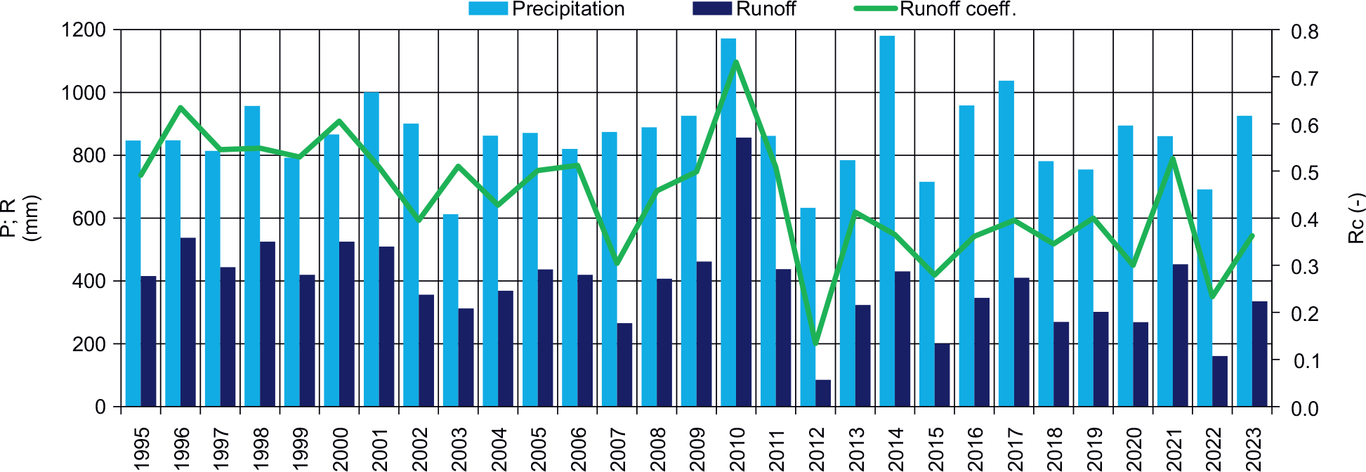
Fig. 3.
Annual totals of precipitation (P), runoff totals (R) and runoff coefficient (Rc) in 1995–2023.
Table 2.
Number of days with precipitation and snow cover in 1995–2023.
| Precipitation (P) | 1995–2023 | 1995–2004 | 2014–2023 |
|---|---|---|---|
| Number of days | |||
| Total | 181 | 184 | 165 |
| ≤1.0 mm | 66 | 68 | 52 |
| 1.0 < P ≤ 5.0 mm | 64 | 67 | 61 |
| 5.0 < P ≤ 10.0 mm | 26 | 26 | 26 |
| 10.0 < P ≤ 20.0 mm | 17 | 16 | 17 |
| 20.0 < P ≤ 30.0 mm | 5 | 3 | 6 |
| 30.0 < P ≤ 50.0 mm | 3 | 3 | 3 |
| >50.0 mm | 1 | 1 | 1 |
| Snow cover | 67 | 81 | 45 |
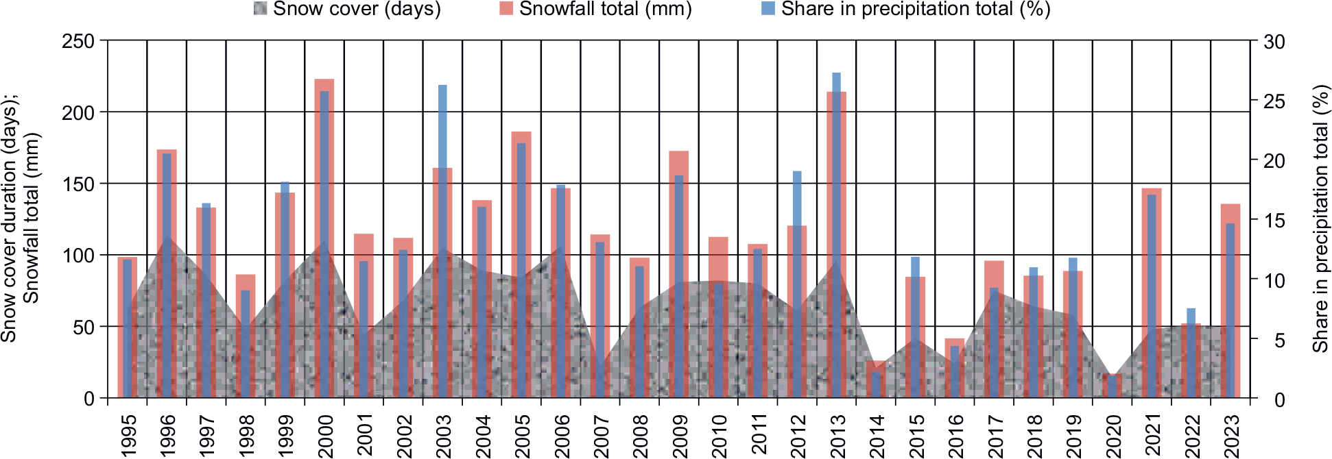
Fig. 4.
Annual SF, share of snowfall in annual precipitation and duration of snow cover. SF, snowfall.
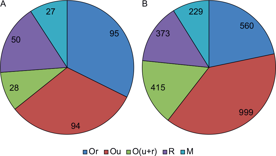
Fig. 5.
A – Number of floods distinguished by genetic classification (Lambor 1965) in 1995–2023; B – layer of water above discharge threshold (mm). Or – continuous rainfall, Ou – heavy rainfall, O(u + r) – mixed rainfall, r – snowmelt, M – mixed rainfall and snowmelt.
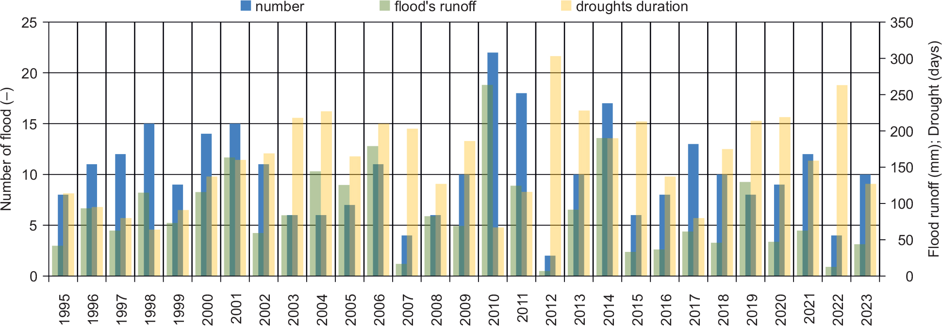
Fig. 6.
Flood runoff and number and hydrological drought duration from 1995 to 2023.
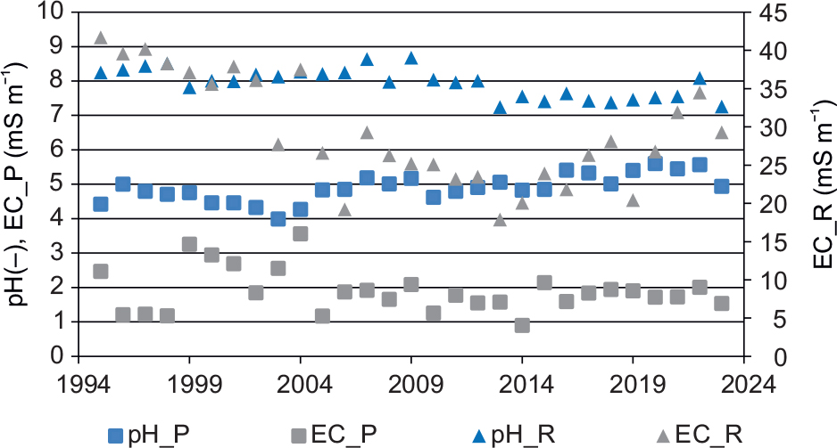
Fig. 7.
Mean annual pH and electrical conductivity (EC) in precipitation (P) and runoff (R).
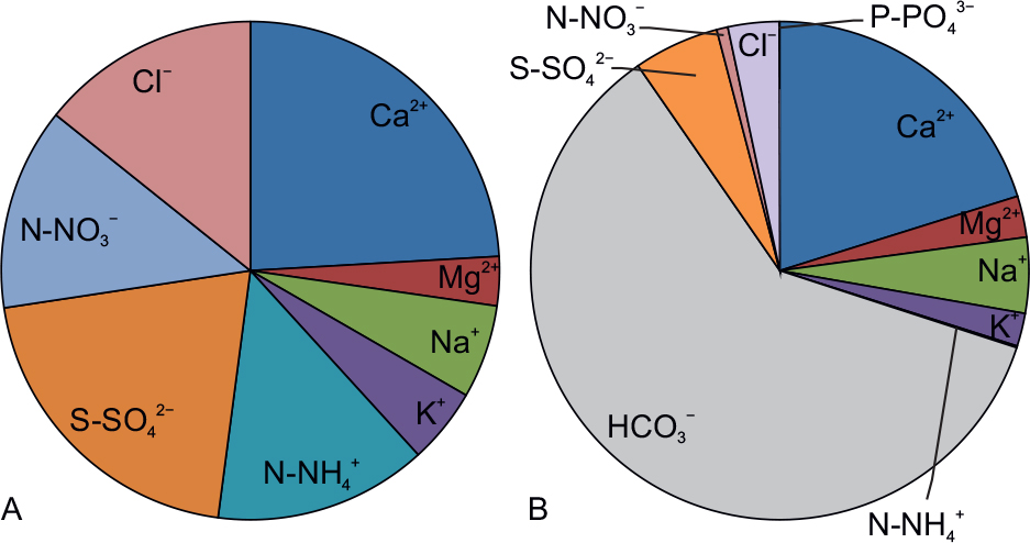
Fig. 8.
Average ion concentration (%) of in A – precipitation and B – runoff.
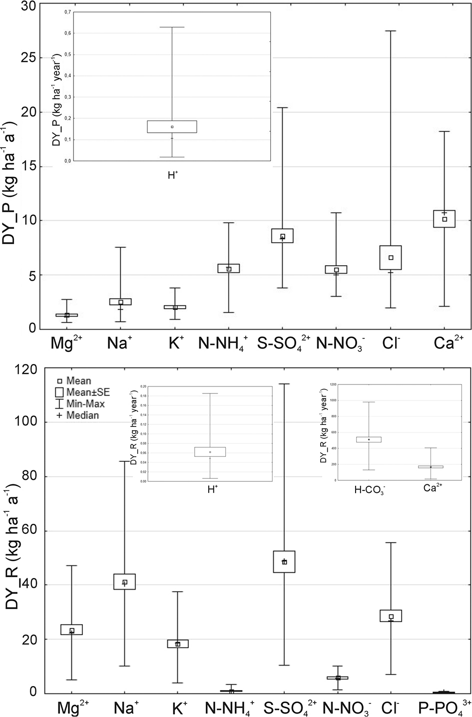
Fig. 9.
Variation in the content of individual ions in dissolved yield precipitation (DY_P) and dissolved yield runoff (dY_r) between 1995 and 2023.
Table 3.
Characteristics of dissolved ion in dissolved yield precipitation (DY_P) and dissolved yield runoff water (DY_R) from 1995 to 2023 (bold: statistically significant p < 0.05).
| Parameter | Precipitation | Runoff | ||||
|---|---|---|---|---|---|---|
| DY_P | Cv | Coefficient | DY_R | Cv | Coefficient | |
| [kg · ha−1 · a−1] | [%] | [kg · ha−1 · a−1] | [%] | |||
| S–SO42– | 8.62 | 40.3 | –0.18 | 48.38 | 45.7 | –1.06 |
| N–NO3– | 5.50 | 32.0 | –0.05 | 5.90 | 39.8 | –0.18 |
| Cl– | 6.61 | 87.5 | –0.05 | 28.48 | 40.2 | –0.39 |
| Na+ | 2.54 | 63.9 | 0.09 | 18.60 | 33.7 | –0.19 |
| K+ | 2.03 | 37.2 | 0.03 | 18.60 | 40.0 | –0.42 |
| Mg2+ | 1.33 | 45.8 | 0.01 | 23.33 | 40.4 | –0.50 |
| Ca2+ | 10.16 | 39.8 | 0.21 | 175.24 | 38.9 | –2.54 |
| N–NH4+ | 5.60 | 37.3 | –0.19 | 0.89 | 92.7 | –0.05 |
| HCO3– | 516.56 | 33.4 | –4.83 | |||
| P–PO43– | 0.41 | 66.5 | –0.02 | |||
| Load (1995–2023) | 4.90 | 28.6 | –0.12 | 859.9 | 33.0 | –0.14 |
| 1995–2004 vs. 2014–2023 | ||||||
| p-value (Mann–Whitney U test) | ||||||
| S–SO42– | 0.054 | 0.004 | ||||
| N–NO3– | 0.241 | 0.000 | ||||
| Cl– | 0.076 | 0.031 | ||||
| Na+ | 0.002 | 0.273 | ||||
| K+ | 0.045 | 0.002 | ||||
| Mg2+ | 0.307 | 0.017 | ||||
| Ca2+ | 0.850 | 0.021 | ||||
| N–NH4+ | 3.062 | 0.017 | ||||
| HCO3– | 0.162 | |||||
| P–PO43– | 0.000 | |||||
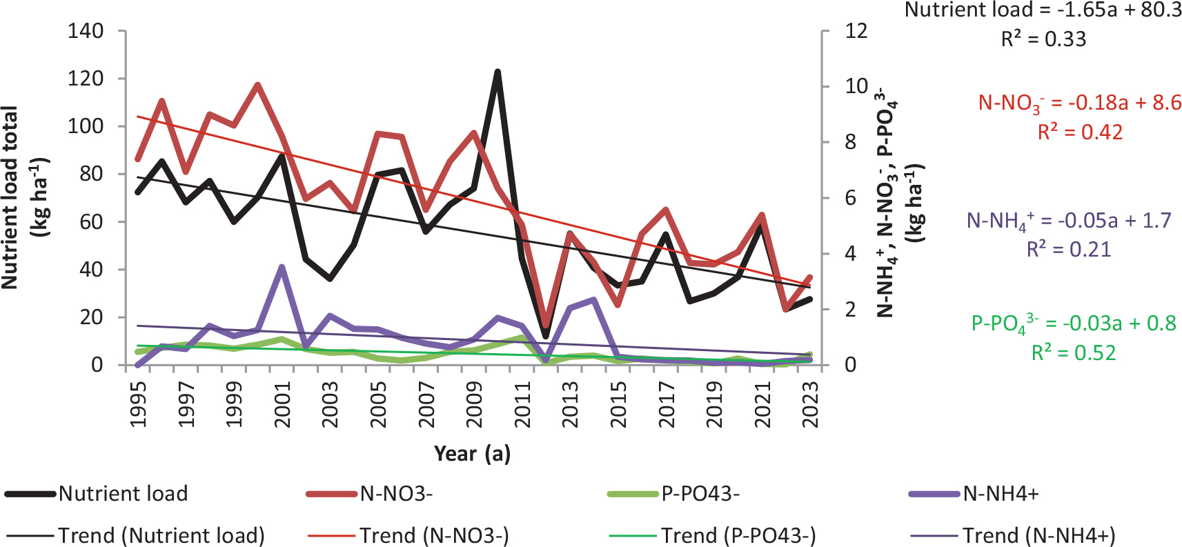
Fig. 10.
Changes in individual nutrients (P–PO43−, N–NO3–, N–NH4+) and total nutrient loads in the Bystrzanka stream between 1995 and 2023.
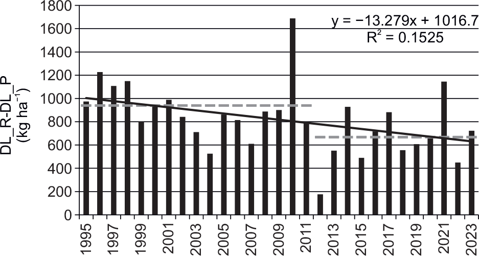
Fig. 11.
Chemical denudation balance in the Bystrzanka catchment between 1995 and 2023.
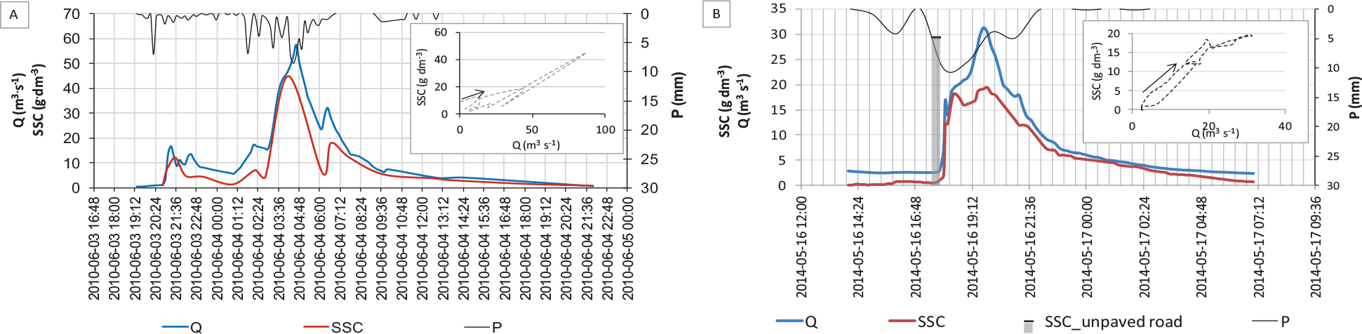
Fig. 12.
Plot of SSC in the stream against discharge (Q) and precipitation (P) during the A – 3–4 June 2010 and B – 16–17 May 2014 flood events with a hysteresis loop and an example of concentration on an unpaved road in the Bystrzanka catchment. SSC, suspended sediment concentration.
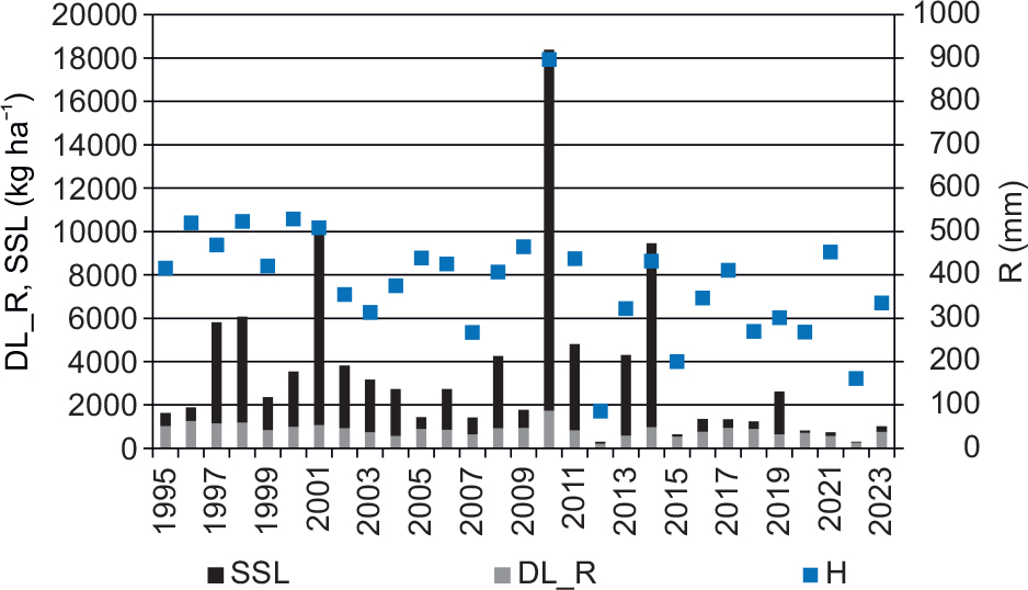
Fig. 13.
DL_R and SSL changes against runoff (R) between 1995 and 2023. DL_R, dissolved load runoff.
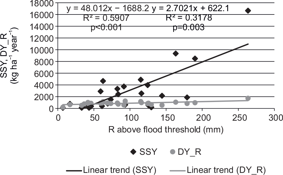
Fig. 14.
Dependence of SSY and DY_R on the runoff above the flood threshold between 1995 and 2023. DY_R, dissolved yield runoff.