
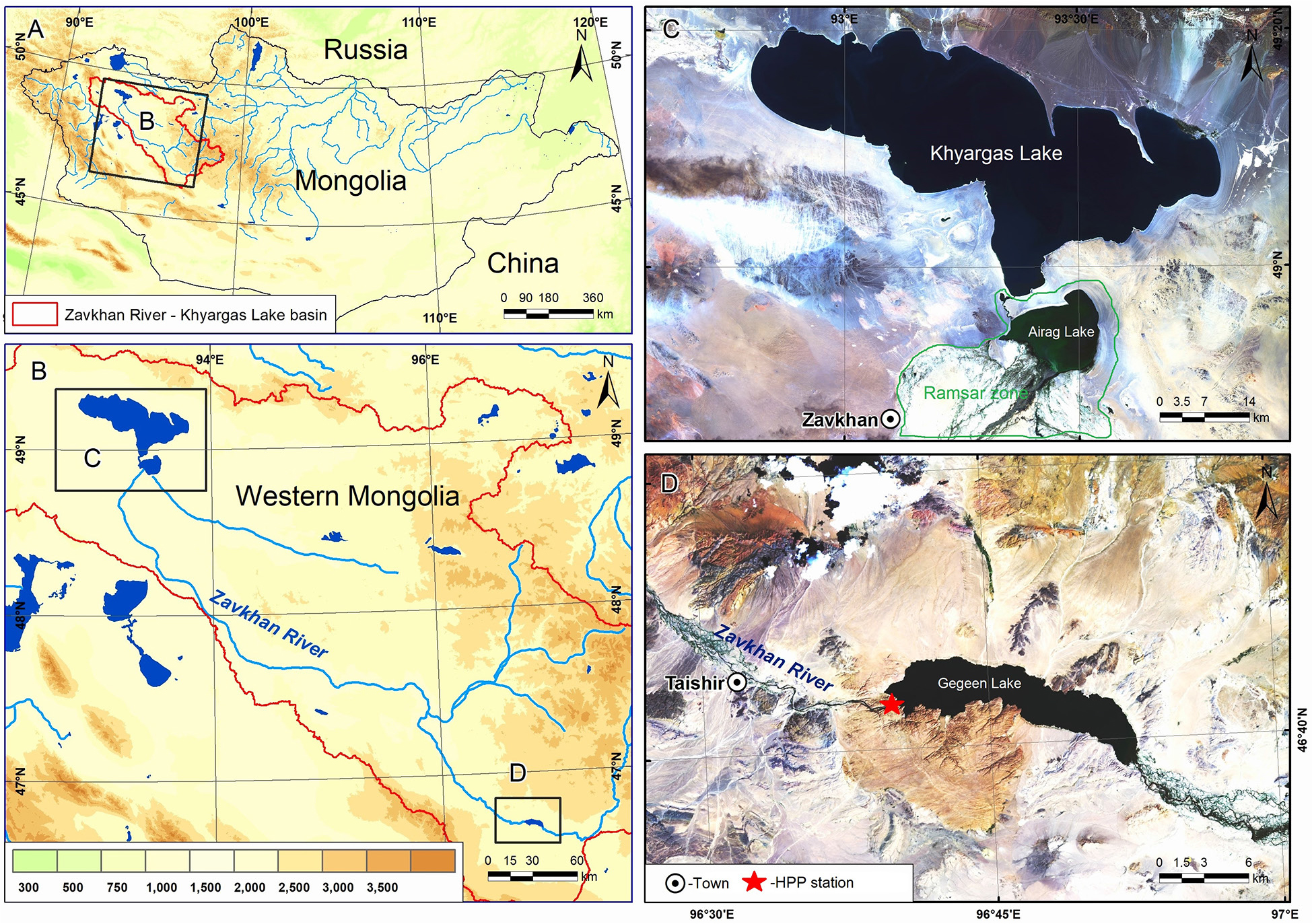
Fig. 1.
A – The geographical location of the study area. B – Topographic map of Mongolia and the Zavkhan River–Khyargas Lake basin in western Mongolia. C – Satellite images of the Airag and Khyargas lakes. D – Gegeen Lake.
Table 1.
Morphometric parameters of the study area (Modified after Tserensodnom 2000; Davaa 2018; Enkhbold et al. 2022; Dorjsuren et al. 2023, 2024).
| Description | Unit | Khyargas Lake | Airag Lake | Gegeen Lake |
|---|---|---|---|---|
| Location | DMS | 49°11'05"N, 93°16'16"E | 48°53'12"N, 93°26'09"E | 46°41'02"N, 96°46'17"E |
| Elevation (m a.s.l.) | m | 1028 | 1030 | 1727 |
| Average area | ha | 138,306 | 15,179 | 3794 |
| Shape | Direction | W–E | W–E | NW–SE |
| Average length | km | 75 | 18 | 17.2 |
| Average width | km | 19 | 13 | 3.1 |
| Depth (max) | m | 78.7 | 10.2 | 31.5 |
| Origin | – | Tectonic | Tectonic | Human |
| Chemistry | – | Salt | Fresh | Fresh |
| Water source | – | Surface | Surface | Surface |
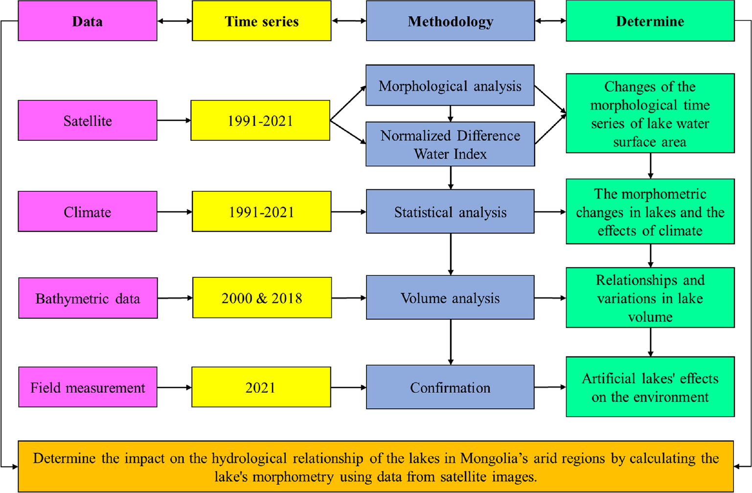
Fig. 2.
Methodology flow chart.
Table 2.
Estimation of water surface area in the Khyargas Lake basin.
| Year | Khyargas Lake area | Airag Lake area | Gegeen Lake area | Satellite imagery considered in the analysis |
|---|---|---|---|---|
| [ha] | ||||
| 1991 | 137,482 | 13,190 | 0.00 | LT05_L1TP_140026_19910811_20170125_01_T1 |
| 1992 | 137,726 | 13,419 | 0.00 | LT05_L1TP_140026_19920813_20170122_01_T1 |
| 1993 | 138,084 | 16,501 | 0.00 | LT05_L1TP_140026_19930816_20170117_01_T1 |
| 1994 | 139,201 | 17,811 | 0.00 | LT05_L1TP_140026_19940718_20170114_01_T1 |
| 1995 | 139,913 | 19,295 | 0.00 | LT05_L1TP_140026_19950822_20170107_01_T1 |
| 1996 | 140,011 | 19,319 | 0.00 | LT05_L1TP_140026_19960621_20170104_01_T1 |
| 1997 | 139,967 | 19,039 | 0.00 | LT05_L1TP_140026_19970827_20161230_01_T1 |
| 1998 | 140,105 | 19,064 | 0.00 | LT05_L1TP_140026_19980611_20161224_01_T1 |
| 1999 | 140,317 | 18,266 | 0.00 | LT05_L1TP_140026_19990716_20161217_01_T1 |
| 2000 | 139,728 | 18,023 | 0.00 | LE07_L1TP_140026_20000827_20170210_01_T1 |
| 2001 | 140,007 | 17,859 | 0.00 | LT05_L1TP_140026_20010806_20161210_01_T1 |
| 2002 | 139,699 | 17,562 | 0.00 | LT05_L1TP_140026_20020809_20161207_01_T1 |
| 2003 | 139,697 | 17,392 | 0.00 | LT05_L1TP_140026_20030727_20161205_01_T1 |
| 2004 | 139,629 | 17,272 | 0.00 | LT05_L1TP_140026_20040713_20161130_01_T1 |
| 2005 | 139,349 | 16,901 | 0.00 | LT05_L1TP_140026_20050817_20161124_01_T1 |
| 2006 | 139,347 | 16,545 | 0.00 | LT05_L1TP_140026_20060719_20161120_01_T1 |
| *LT05_L1TP_138027_20060619_20161121_01_T1 | ||||
| 2007 | 139,124 | 15,923 | 89 | LT05_L1TP_140026_20070823_20161112_01_T1 |
| *LT05_L1TP_138027_20070825_20161111_01_T1 | ||||
| 2008 | 138,609 | 15,125 | 1521 | LT05_L1TP_140026_20080809_20161030_01_T1 |
| *LT05_L1TP_138027_20080811_20161030_01_T1 | ||||
| 2009 | 138,144 | 14,331 | 1801 | LT05_L1TP_140026_20090711_20161024_01_T1 |
| *LT05_L1TP_138027_20090713_20161023_01_T1 | ||||
| 2010 | 138,167 | 13,808 | 3235 | LT05_L1TP_140026_20100730_20161014_01_T1 |
| *LT05_L1TP_138027_20100716_20161014_01_T1 | ||||
| 2011 | 137,571 | 13,314 | 4749 | LT05_L1TP_140026_20110818_20161007_01_T1 |
| *LT05_L1TP_137028_20110728_20161008_01_T1 | ||||
| 2012 | 137,453 | 13,096 | 4540 | LE07_L1TP_140026_20120711_20161130_01_T1 |
| *LE07_L1TP_138027_20120814_20161129_01_T1 | ||||
| 2013 | 136,661 | 12,429 | 4431 | LC08_L1TP_140026_20130823_20170502_01_T1 |
| *LC08_L1TP_137028_20130701_20170503_01_T1 | ||||
| 2014 | 136,428 | 11,992 | 4729 | LC08_L1TP_140026_20140826_20170420_01_T1 |
| *LC08_L1TP_138027_20140812_20170420_01_T1 | ||||
| 2015 | 136,130 | 11,524 | 4363 | LC08_L1TP_140026_20150813_20170406_01_T1 |
| *LC08_L1TP_137028_20150808_20180524_01_T1 | ||||
| 2016 | 136,300 | 12,108 | 5297 | LC08_L1TP_140026_20160714_20170323_01_T1 |
| *LC08_L1TP_137028_20160810_20170322_01_T1 | ||||
| 2017 | 136,477 | 11,877 | 4715 | LC08_L1TP_140026_20170717_20170727_01_T1 |
| *LC08_L1TP_137028_20170712_20170726_01_T1 | ||||
| 2018 | 136,298 | 11,585 | 4251 | LC08_L1TP_140026_20180821_20180829_01_T1 |
| *LC08_L1TP_137028_20180816_20180829_01_T1 | ||||
| 2019 | 136,263 | 11,556 | 4710 | LC08_L1TP_140026_20190824_20190903_01_T1 |
| *LC08_L1TP_138027_20190826_20190903_01_T1 | ||||
| 2020 | 137,064 | 11,529 | 3797 | LE07_L1TP_140026_20200818_20200913_01_T1 |
| *LC08_L1TP_138027_20200727_20200807_01_T1 | ||||
| 2021 | 136,545 | 12,904 | 4686 | LC08_L1TP_140026_20210813_20210819_01_T1 |
| *LC08_L1TP_137028_20210824_20210831_01_T1 | ||||
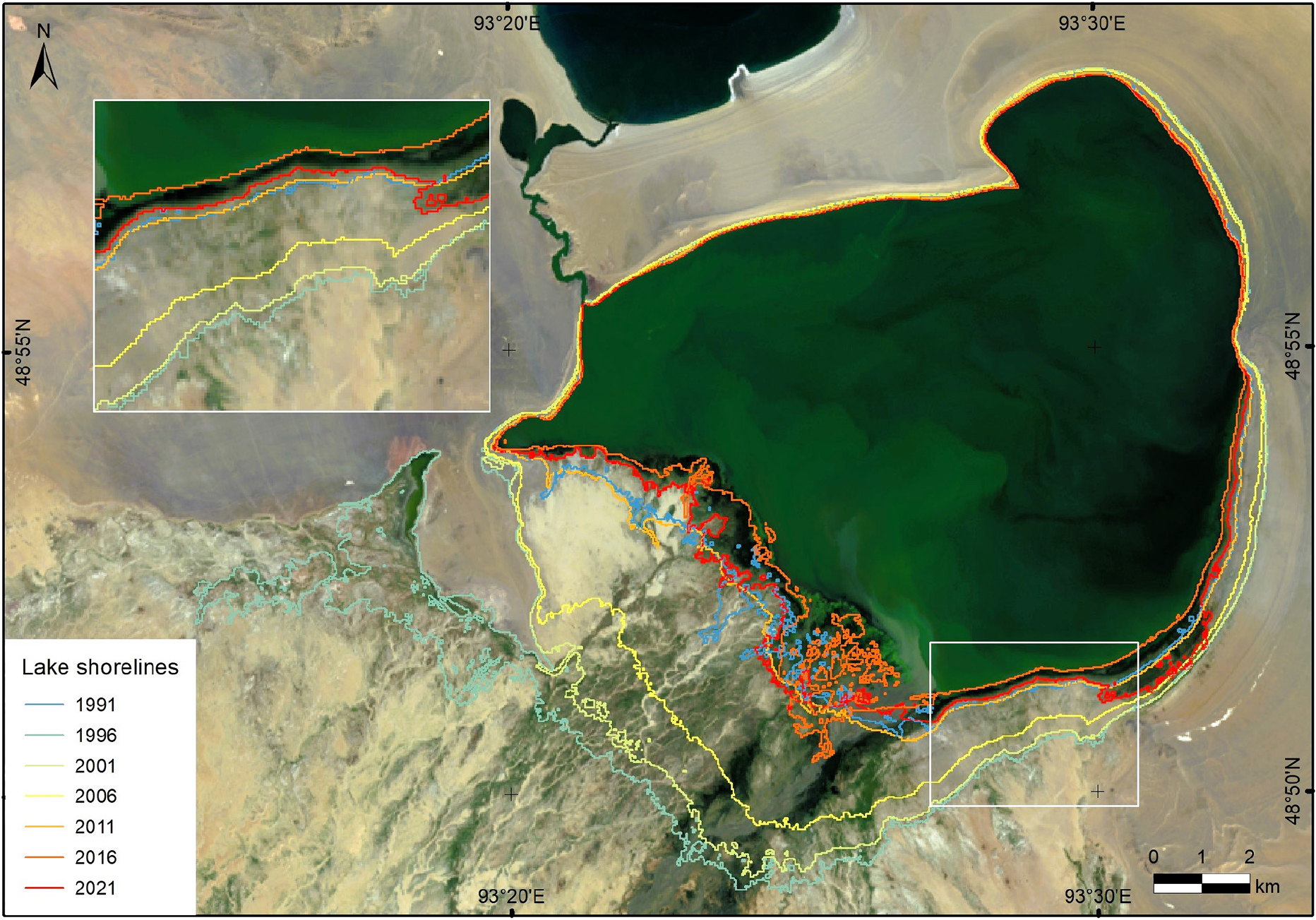
Fig. 3.
Morphological changes in the area of Airag Lake (1991–2021).
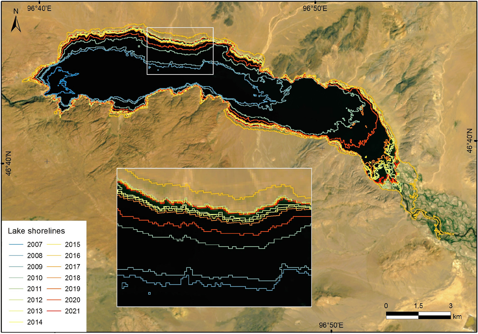
Fig. 4.
Morphological changes in the area of Gegeen Lake (2007–2021).
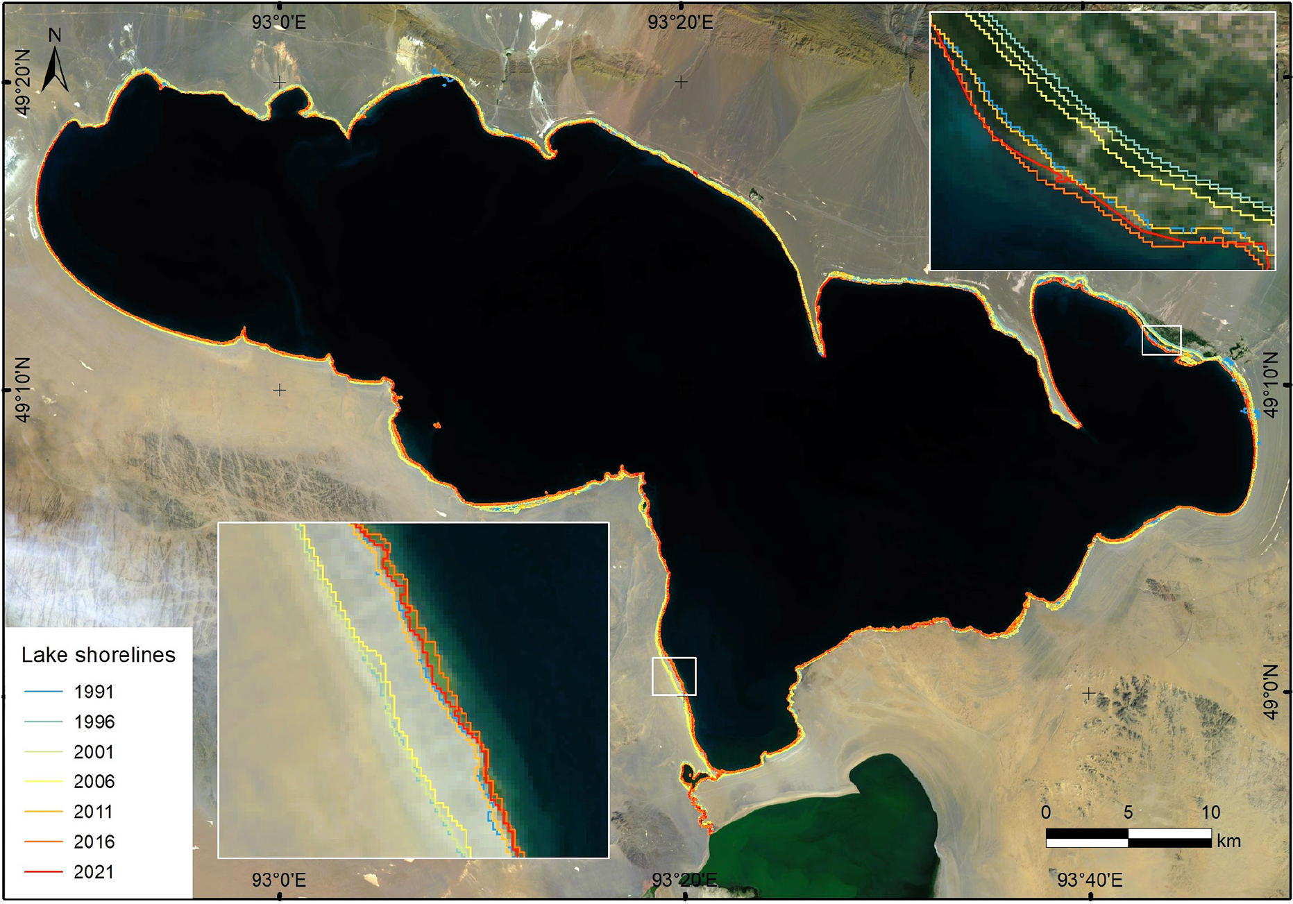
Fig. 5.
Morphological changes in the area of Khyargas Lake (1991–2021).
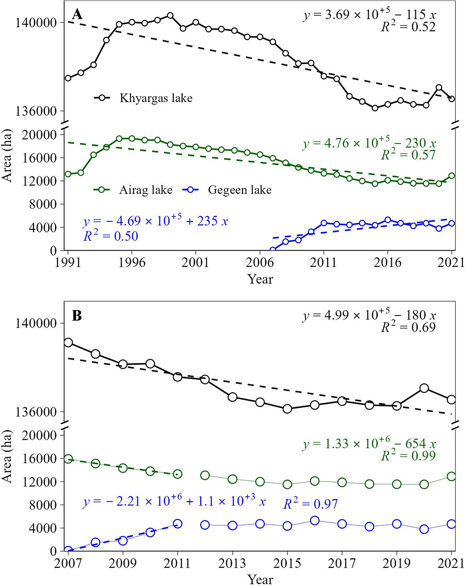
Fig. 6.
A – Temporal changes in the water surface area of the Khyargas Lake basin. B – Surface area trends for the water accumulation (2007–2011) and after the accumulation period of Gegeen Lake (2011–2021).
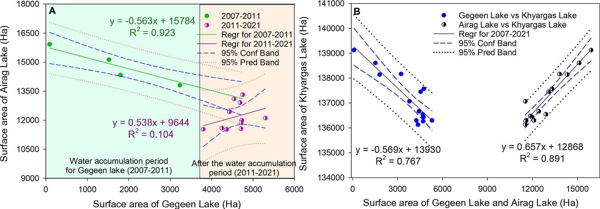
Fig. 7.
A – Relationship of surface area changes between the Gegeen and Airag lakes. The light green background represents the water accumulation period for Gegeen Lake, while the light orange background corresponds to the water accumulation period of the lake. B – Relationship of surface area changes for Khargas Lake with the Gegeen and Airag lakes.
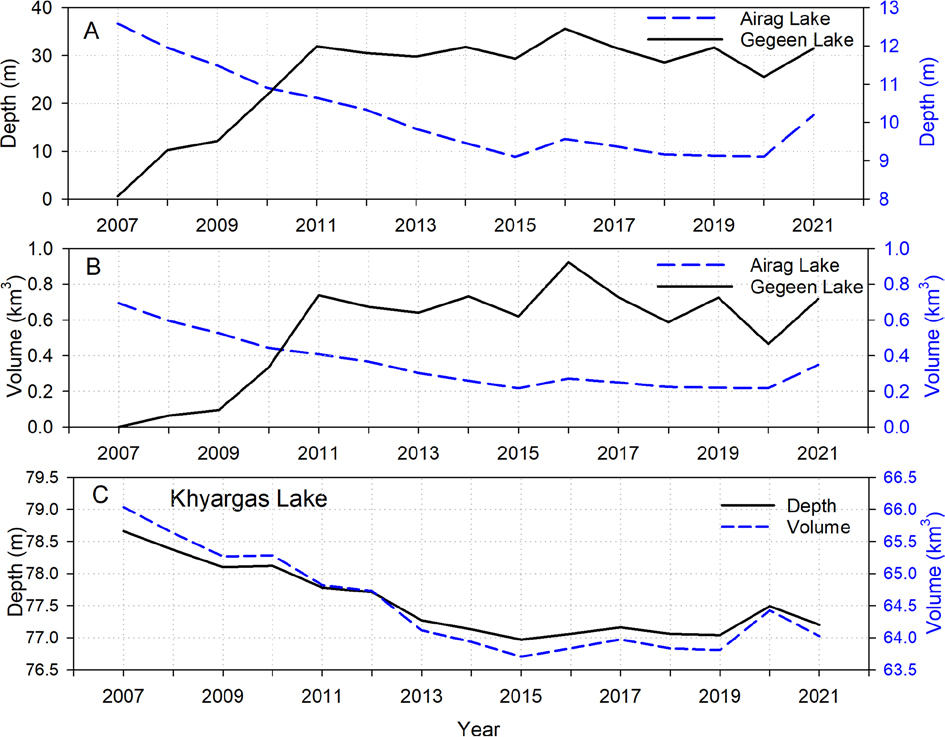
Fig. 8.
Variations in morphometric changes in the lakes. A – Depth change; B – volume change of the Airag and Gegeen lakes and C – depth and volume changes of Khyargas Lake.
Table 3.
Changes in the depth and volume of the Khyargas Lake basin (2007–2021).
| Serial No. | Year | Airag Lake | Gegeen Lake | Khyargas Lake | |||
|---|---|---|---|---|---|---|---|
| Depth | Volume | Depth | Volume | Depth | Volume | ||
| [m] | [km3] | [m] | [km3] | [m] | [km3] | ||
| 1 | 2007 | 12.587 | 0.694 | 0.598 | 0.001 | 78.66 | 66.034 |
| 2 | 2008 | 11.956 | 0.596 | 10.224 | 0.064 | 78.37 | 65.630 |
| 3 | 2009 | 11.491 | 0.527 | 12.107 | 0.095 | 78.10 | 65.266 |
| 4 | 2010 | 10.905 | 0.444 | 21.746 | 0.335 | 78.12 | 65.283 |
| 5 | 2011 | 10.643 | 0.408 | 31.923 | 0.738 | 77.78 | 64.819 |
| 6 | 2012 | 10.333 | 0.367 | 30.519 | 0.673 | 77.71 | 64.727 |
| 7 | 2013 | 9.834 | 0.304 | 29.786 | 0.640 | 77.27 | 64.113 |
| 8 | 2014 | 9.465 | 0.259 | 31.789 | 0.732 | 77.13 | 63.934 |
| 9 | 2015 | 9.107 | 0.216 | 29.329 | 0.620 | 76.97 | 63.704 |
| 10 | 2016 | 9.572 | 0.271 | 35.607 | 0.923 | 77.06 | 63.835 |
| 11 | 2017 | 9.385 | 0.249 | 31.695 | 0.727 | 77.16 | 63.972 |
| 12 | 2018 | 9.169 | 0.224 | 28.576 | 0.588 | 77.06 | 63.833 |
| 13 | 2019 | 9.136 | 0.220 | 31.661 | 0.726 | 77.04 | 63.806 |
| 14 | 2020 | 9.113 | 0.217 | 25.524 | 0.465 | 77.49 | 64.426 |
| 15 | 2021 | 10.200 | 0.350 | 31.500 | 0.718 | 77.20 | 64.024 |
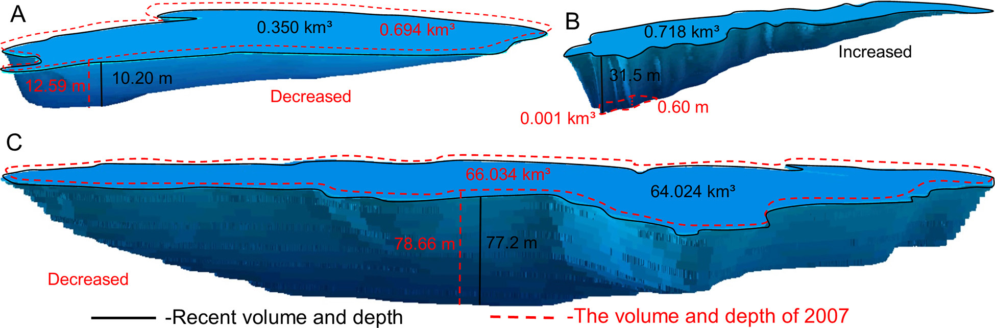
Fig. 9.
Three-dimensional model of water volume changes in lakes. Morphometric changes in A – Airag Lake, B – Gegeen Lake and C – Khyargas Lake.
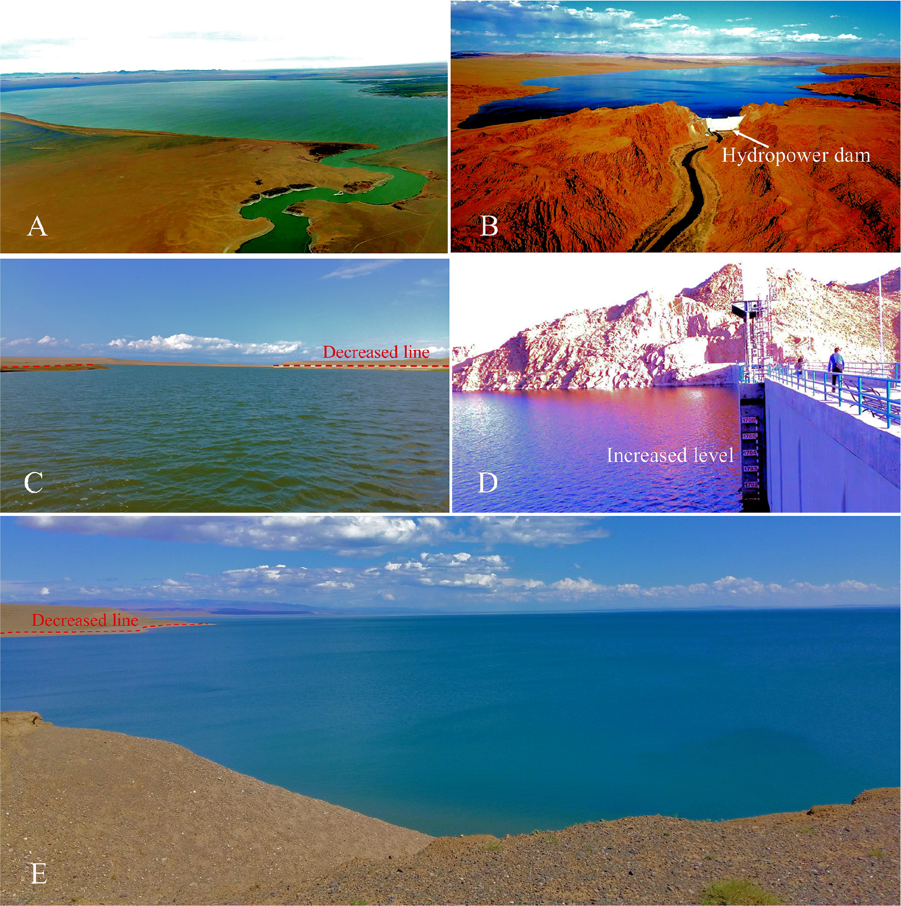
Fig. 10.
Photograph of the lakes. A – Airag Lake aerial photo, photo by Batbold Dorj; B – Gegeen Lake aerial photo, photo by Dorjzovd Enkhtur; C – Airag Lake water level decline; D – The level of water increase in the Gegeen Lake and E – Khyargas Lake water level decline, photo by Altanbold Enkhbold.
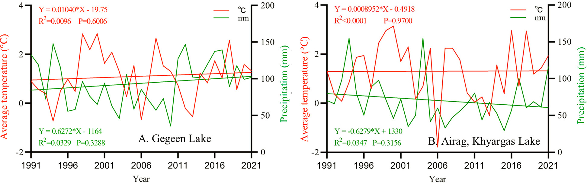
Fig. 11.
Climate trends in years 1991–2021.