
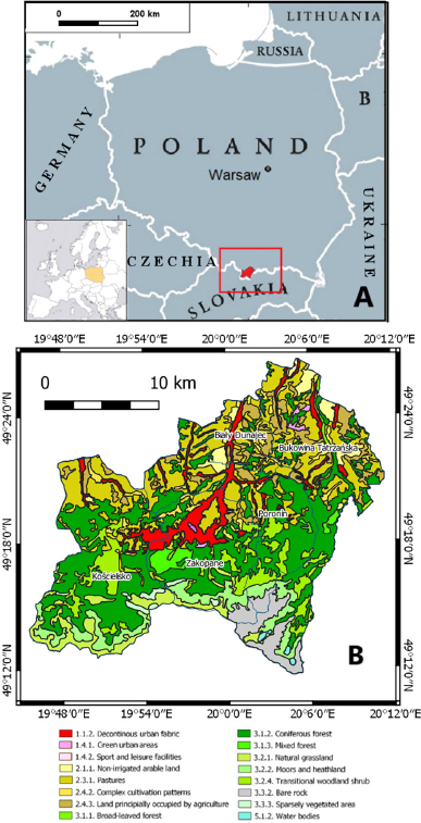
Fig. 1.
Location of the Tatra region in Poland (A) with information about its CORINE Land Cover classes (B).
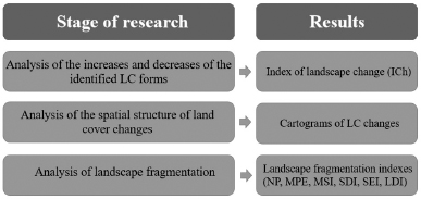
Fig. 2.
Methodology workflow.
Table 1.
Landscape fragmentation indexes.
| Index | Name | Formula | Notes | Level of operation* | Source |
|---|---|---|---|---|---|
| NP | Number of Patches | – | – | Landscape level | |
| MPE | Mean Patch Edge | MPE = (e1 + e2 + … + en) ÷ n | e – edge of the patch (m) n – the number of patches in the selected LC class | Class level | McGarigal and Marks (1995), Zhang and Wang (2006) |
| MSI | Mean Shape Index | MSI = (e ÷ A) | e – edge of the patch (m) A – total area of landscape | Class level | McGarigal and Marks (1995), Zhang and Wang (2006), |
| SDI | Shannon’s Diversity Index | pi – proportion of individuals belonging to the ith LC class in the landscape | Landscape level | Urbański (2008), Sobala and Pukowiec-Kurda (2016) | |
| SEI | Shannon’s Evenness Index | SEI = (SDI ÷ max(SDI)) | SDI – actual value of Shannon’s Diversity Index max (SDI) – maximal possible SDI value | Landscape level | Urbański (2008) |
| DIVISION | Landscape Division Index | i – LC class aij – area (m2) of the patch A – total area of landscape | Class level | Urbański (2008) |
Table 2.
Values of index of landscape change for particular land cover forms according to the CORINE Land Cover classification in the Tatra region (ICh value—green colour when the share of a given LC form has increased and red colour when the share of a given LC has decreased).
| CLC code | Area [ha] | ICh [%] | ||||||
|---|---|---|---|---|---|---|---|---|
| 2000 | 2006 | 2012 | 2018 | ICh00–06 | ICh06–12 | ICh12–18 | ICh00–18 | |
| 112 | 1735.21 | 1839.39 | 2399.88 | 2972.04 | 0.11 | 0.59 | 0.61 | 1.31 |
| 141 | 0.00 | 18.78 | 17.05 | 18.18 | 0.02 | 0.00 | 0.00 | 0.02 |
| 142 | 23.10 | 22.95 | 21.24 | 129.36 | 0.00 | 0.00 | 0.11 | 0.11 |
| 211 | 2634.21 | 2687.80 | 16258.58 | 4626.12 | 0.06 | 14.39 | 12.33 | 2.11 |
| 231 | 14225.05 | 14317.34 | 4284.58 | 12295.75 | 0.10 | 10.64 | 8.49 | 2.05 |
| 242 | 2079.09 | 1904.76 | 982.94 | 910.70 | 0.18 | 0.98 | 0.08 | 1.24 |
| 243 | 3136.02 | 3035.51 | 2387.99 | 2341.27 | 0.11 | 0.69 | 0.05 | 0.84 |
| 311 | 97.59 | 458.98 | 113.98 | 121.66 | 0.38 | 0.37 | 0.01 | 0.03 |
| 312 | 14856.89 | 14811.78 | 13638.78 | 13243.95 | 0.05 | 1.24 | 0.42 | 1.71 |
| 313 | 679.73 | 388.05 | 451.19 | 582.83 | 0.31 | 0.07 | 0.14 | 0.10 |
| 321 | 2406.07 | 2403.38 | 2074.84 | 2697.85 | 0.00 | 0.35 | 0.66 | 0.31 |
| 322 | 2159.93 | 2151.63 | 2057.61 | 2033.98 | 0.01 | 0.10 | 0.03 | 0.13 |
| 324 | 410.64 | 429.77 | 456.00 | 2874.62 | 0.02 | 0.03 | 2.56 | 2.61 |
| 332 | 2348.89 | 2322.01 | 1646.70 | 1783.19 | 0.03 | 0.72 | 0.14 | 0.60 |
| 333 | 291.07 | 291.38 | 279.61 | 436.38 | 0.00 | 0.01 | 0.17 | 0.15 |
| 511 | 0.00 | 0.00 | 18.88 | 20.04 | 0.00 | 0.02 | 0.00 | 0.02 |
| 512 | 76.53 | 76.50 | 70.15 | 72.06 | 0.00 | 0.01 | 0.00 | 0.00 |
| Overall ICh | 1.38 | 30.19 | 25.81 | 13.36 | ||||
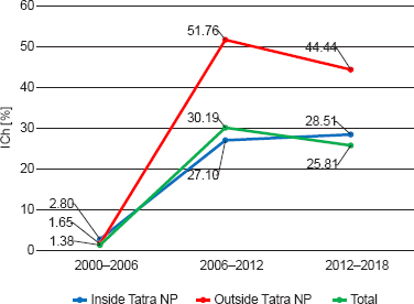
Fig. 3.
Index of landscape change (ICh) inside and outside Tatra NP in the period of 2000–2018.
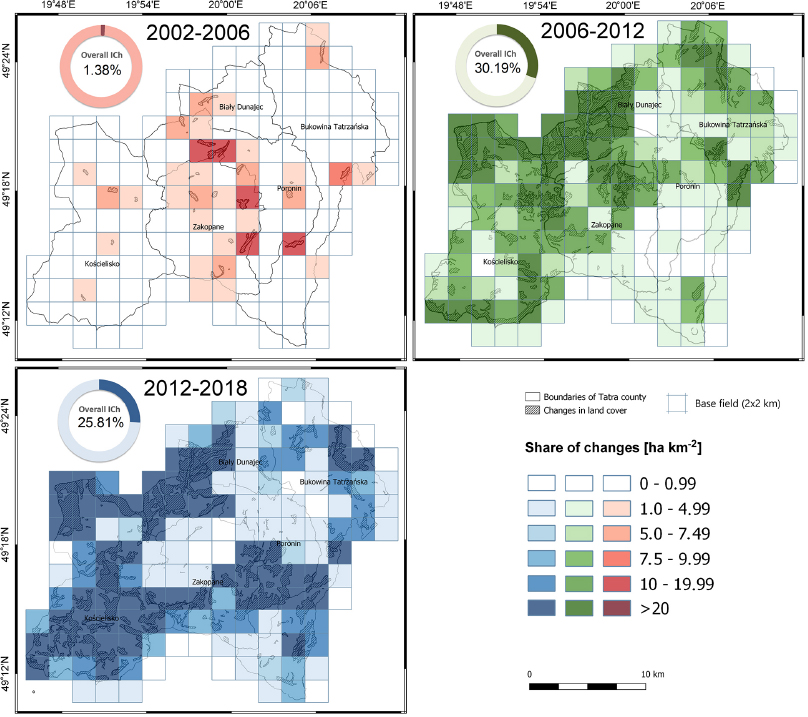
Fig. 4.
Land cover changes in the Tatra region in the 2000–2006–2012–2018 periods.
Table 3.
Mean Patch Edge (MPE) in the Tatra region in the 2000-2018 period for selected LC forms.
| CLC code | MPE [m] | ||||
|---|---|---|---|---|---|
| 2000 | 2006 | 2012 | 2018 | ||
| 112 | 14 367.00 | 12 397.14 | 15 228.02 | 15 063.99 | |
| 141 | 0.00 | 2 557.64 | 2 557.64 | 2 557.64 | |
| 142 | 3 109.36 | 3 109.36 | 3 109.36 | 8 495.38 | |
| 211 | 12 735.41 | 12 735.33 | 26 570.53 | 4 144.60 | |
| 231 | 12 429.33 | 12 495.35 | 9 969.87 | 11 031.61 | |
| 242 | 5 588.21 | 5 506.85 | 5 453.74 | 4 733.83 | |
| 243 | 5 265.41 | 5 393.80 | 5 577.05 | 5 478.32 | |
| 311 | 3 824.21 | 3 934.29 | 3 804.81 | 3 784.66 | |
| 312 | 18 097.87 | 17 500.69 | 15 868.58 | 17 768.00 | |
| 313 | 9 271.88 | 10 256.72 | 10 259.33 | 7 865.39 | |
| 321 | 7 880.22 | 7 945.46 | 10 764.73 | 12 471.43 | |
| 322 | 14 040.35 | 14 004.48 | 14 659.31 | 22 307.29 | |
| 324 | 4 266.16 | 4 284.40 | 3 943.19 | 6 878.49 | |
| 332 | 13 777.95 | 13 595.98 | 10 604.71 | 54 742.03 | |
| 333 | 1 229.49 | 1 229.49 | 3 191.27 | 3 698.45 | |
| 511 | 0.00 | 2 623.02 | 3 690.03 | 3 533.54 | |
| 512 | 2 623.03 | 12 397.14 | 2 620.30 | 2 616.70 | |
| Overall MPE | 9451.12 | 9413.86 | 9964.18 | 9822.28 | |
Table 4.
Mean Shape Index (MSI) in the Tatra region in the 2000–2018 period for selected land cover forms.
| LC class | MSI [m] | ||||
|---|---|---|---|---|---|
| 2000 | 2006 | 2012 | 2018 | ||
| 112 | 2.991 | 2.767 | 2.816 | 2.736 | |
| 141 | – | 1.398 | 1.398 | 1.398 | |
| 142 | 1.523 | 1.523 | 1.523 | 2.342 | |
| 211 | 2.688 | 2.688 | 2.835 | 1.672 | |
| 231 | 2.244 | 2.212 | 2.332 | 2.291 | |
| 242 | 2.019 | 2.010 | 1.997 | 1.886 | |
| 243 | 1.877 | 1.894 | 1.904 | 1.884 | |
| 311 | 1.785 | 1.822 | 1.807 | 1.776 | |
| 312 | 2.488 | 2.468 | 2.430 | 2.515 | |
| 313 | 2.152 | 2.400 | 2.294 | 3.117 | |
| 321 | 2.815 | 2.819 | 2.575 | 2.319 | |
| 322 | 2.441 | 2.436 | 2.378 | 2.722 | |
| 324 | 2.267 | 2.041 | 1.918 | 2.418 | |
| 332 | 2.586 | 2.570 | 2.097 | 3.499 | |
| 333 | 3.986 | 3.986 | 2.592 | 2.018 | |
| 511 | – | – | 2.696 | 2.840 | |
| 512 | 1.209 | 1.209 | 1.210 | 1.227 | |
| Overall MSI | 2.276 | 2.259 | 2.238 | 2.228 | |
Table 5.
Landscape Division Index (LDI) in the Tatra region in the 2000–2018 period for selected land cover forms.
| LC form | LDI | ||||
|---|---|---|---|---|---|
| 2000 | 2006 | 2012 | 2018 | ||
| 112 | 71.76 | 73.94 | 50.33 | 57.49 | |
| 141 | – | 0.00 | 0.00 | 0.00 | |
| 142 | 0.00 | 0.00 | 0.00 | 30.58 | |
| 211 | 34.04 | 34.04 | 56.92 | 82.11 | |
| 231 | 90.60 | 90.44 | 87.08 | 94.10 | |
| 242 | 95.09 | 95.31 | 94.59 | 94.93 | |
| 243 | 96.87 | 96.76 | 96.36 | 96.17 | |
| 311 | 44.77 | 63.08 | 60.24 | 60.85 | |
| 312 | 20.28 | 21.11 | 60.88 | 67.30 | |
| 313 | 30.45 | 34.55 | 28.36 | 47.02 | |
| 321 | 80.29 | 79.67 | 73.01 | 67.98 | |
| 322 | 77.17 | 77.10 | 77.61 | 65.80 | |
| 324 | 90.17 | 89.94 | 80.62 | 88.58 | |
| 332 | 42.58 | 41.15 | 25.74 | 0.00 | |
| 333 | 44.23 | 44.23 | 62.15 | 77.02 | |
| 511 | – | 0.00 | 0.00 | 0.00 | |
| 512 | 62.71 | 62.71 | 62.61 | 64.07 | |
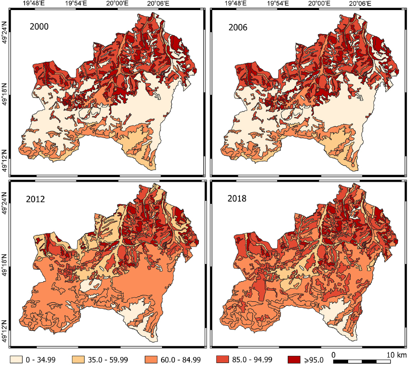
Fig. 5.
Landscape Division Index values in the Tatra region in the 2000–2018 period for each patch of landscape.