
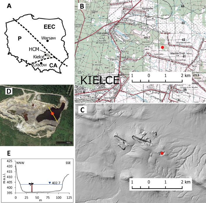
Fig. 1.
Location of Podwiśniówka pit lake against A – significant geotectonic structures (Żylińska et al. 2006), namely Holy Cross Mountains (HCM), Precambrian East European Craton (EEC), Palaeozoic Caledonian and Variscan fold belt (P) and Carpathian Alpine orogenic belt (CA); B – a topographic map; C – Digital Elevation Model; D – orthophoto maps (https://earth.google.com); E – relief profile. The red dots in B–D and the boat symbol in E indicate measurements in the lake.
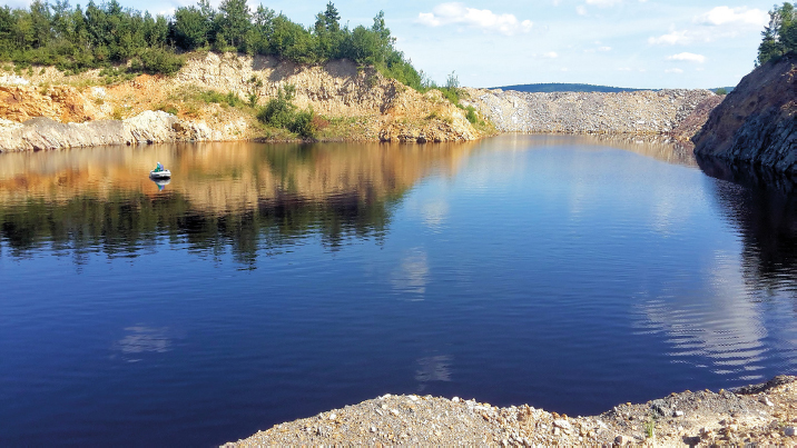
Fig. 2.
Podwiśniówka mine pit lake (the boat indicates the site of measurement).
Table 1.
Global reference surface water values (Salminen et al. 2005) and for the upper continental crust (McLennan 2001).
| Feature | U | Cd | As | Tl | Co | Cu | Ni | Pb | Cr | Zn | |
|---|---|---|---|---|---|---|---|---|---|---|---|
| Reference values | Surface water – world [μg · L–1] | 0.5 | 0.2 | 2.0 | 0.01 | 0.3 | 7.0 | 2.5 | 0.3 | 1.0 | 20 |
| Rock – upper continental crust [μg · kg–1] | 2800 | 98 | 1500 | 750 | 17,000 | 25,000 | 44,000 | 20,000 | 83,000 | 71,000 | |
| Standard WHO (2022) [μg · L–1] | 30* | 3 | 10 | – | – | 2000 | 70 | 10 | 50 | – | |
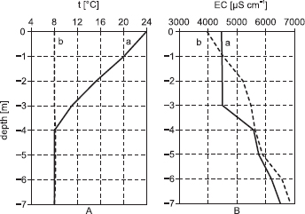
Fig. 3.
Temperature – A and electrolytic conductivity – B of water in the vertical column of the mine pit lake during summer – a and autumn – b.
Table 2.
Dry matter (TDS), salinity and concentration of selected ions in the water column (every 1 m) of the Podwiśniówka mine pit lake on 18 November 2018.
| Depth [m] | TDS [mg · L–1] | Salinity [%] | Fetot. = Fe(3+) + Fe(2+) | Fe2+ | SO42– | PO43– |
|---|---|---|---|---|---|---|
| [mg · L–1] | ||||||
| 0 | 2580 | 2.9 | 739 | 12 | 3110 | 16.2 |
| 1 | 2938 | 3.2 | 736 | 12 | 3110 | 13.3 |
| 2 | 3383 | 3.7 | 762 | 12 | 3090 | 11.6 |
| 3 | 3562 | 3.9 | 741 | 21 | 3000 | 15.6 |
| 4 | 3656 | 4.1 | 774 | 34 | 3060 | 14.2 |
| 5 | 3822 | 4.3 | 770 | 79 | 3090 | 15.3 |
| 6 | 4258 | 4.7 | 808 | 100 | 3460 | 15.6 |
| 7 | 4453 | 4.9 | 842 | 130 | 3390 | 18.4 |
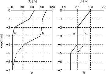
Fig. 4.
Water saturation with oxygen – A and water pH – B in the vertical column of the mine pit lake: a – summer, b – autumn.
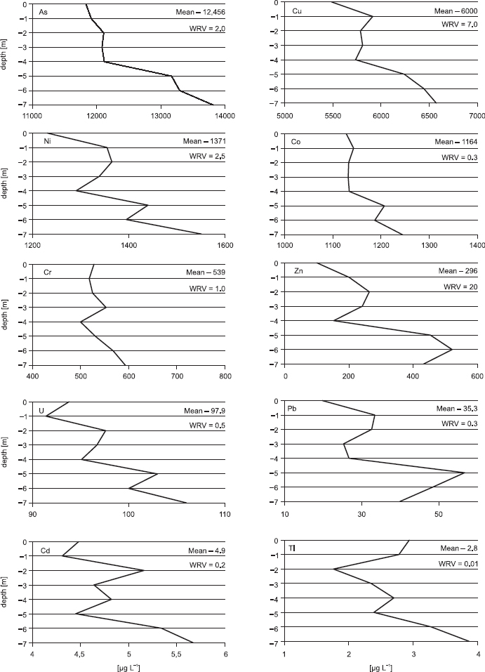
Fig. 5.
Metal/metalloid concentrations in the vertical column of the mine pit lake: mean (μg · L–1). WRV means the global water reference value [μg · L–1] after Salminen et al. (2005).
Table 3.
Correlation matrix between metal/metalloid concentrations in water.
| As | Cu | Ni | Co | Cr | Zn | U | Pb | Cd | Tl | |
|---|---|---|---|---|---|---|---|---|---|---|
| As | 1.00 | |||||||||
| Cu | 0.95 | 1.00 | ||||||||
| Ni | 0.88 | 0.91 | 1.00 | |||||||
| Co | 0.97 | 0.92 | 0.91 | 1.00 | ||||||
| Cr | 0.77 | 0.75 | 0.72 | 0.72 | 1.00 | |||||
| Zn | 0.90 | 0.93 | 0.80 | 0.82 | 0.68 | 1.00 | ||||
| U | 0.93 | 0.82 | 0.86 | 0.90 | 0.72 | 0.82 | 1.00 | |||
| Pb | 0.77 | 0.81 | 0.70 | 0.74 | 0.35 | 0.90 | 0.68 | 1.00 | ||
| Cd | 0.67 | 0.63 | 0.61 | 0.55 | 0.70 | 0.55 | 0.66 | 0.23 | 1.00 | |
| Tl | 0.61 | 0.58 | 0.43 | 0.63 | 0.64 | 0.34 | 0.38 | 0.15 | 0.47 | 1.00 |
Table 4.
The results of the single pollution index (SPI) calculations for given metals/metalloids in the vertical column of the pit lake against mean values and standard deviations (SD). IPI – integrated pollution index.
| Depth [m] | SPI | IPI | |||||||||
|---|---|---|---|---|---|---|---|---|---|---|---|
| As | Co | Cu | Ni | Cr | Tl | U | Pb | Cd | Zn | ||
| 0 | 5916 | 3760 | 784.1 | 492.4 | 528.0 | 294.0 | 187.6 | 66.0 | 22.4 | 5.1 | 1206 |
| 1 | 5957 | 3810 | 844.9 | 542.0 | 518.0 | 278.0 | 182.8 | 111.3 | 21.6 | 10.1 | 1228 |
| 2 | 6055 | 3777 | 826.7 | 546.0 | 525.0 | 176.0 | 195.2 | 108.7 | 25.8 | 13.2 | 1225 |
| 3 | 6041 | 3773 | 829.9 | 535.6 | 553.0 | 235.0 | 193.4 | 84.3 | 23.2 | 12.1 | 1228 |
| 4 | 6059 | 3780 | 819.6 | 516.4 | 500.0 | 270.0 | 190.2 | 89.0 | 24.1 | 7.7 | 1225 |
| 5 | 6583 | 4023 | 891.7 | 576.0 | 531.0 | 239.0 | 206.0 | 189.0 | 22.3 | 22.7 | 1328 |
| 6 | 6648 | 3957 | 920.7 | 558.0 | 568.0 | 328.0 | 200.0 | 161.3 | 26.7 | 26.1 | 1339 |
| 7 | 6909 | 4150 | 939.1 | 620.4 | 593.0 | 387.0 | 212.0 | 133.0 | 28.4 | 21.7 | 1399 |
| Mean | 6271 | 3879 | 857.1 | 548.4 | 539.5 | 275.9 | 195.9 | 117.8 | 24.3 | 14.8 | 1272 |
| SD | 356.1 | 137.2 | 50.6 | 36.1 | 28.0 | 59.6 | 9.1 | 38.7 | 2.3 | 7.2 | 67.7 |
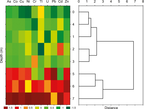
Fig. 6.
Heatmap for hierarchical clustering of the single pollution index (SPI) in the vertical water column.
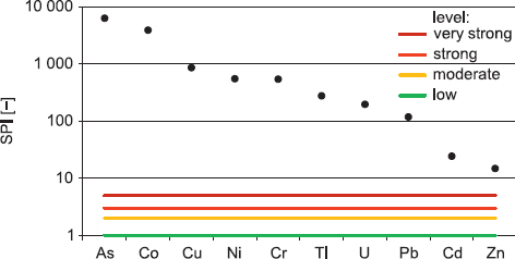
Fig. 7.
Single pollution index (SPI) for heavy metals/metalloids.
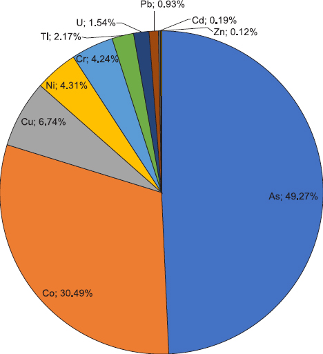
Fig. 8.
Share of individual metals/metalloids in the integrated pollution index (IPI).
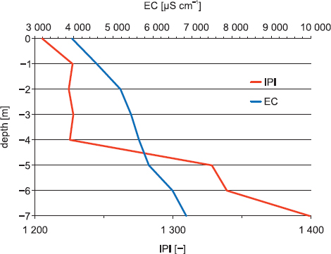
Fig. 9.
Integrated pollution index (IPI) and electrical conductivity (EC) in the vertical water column.