
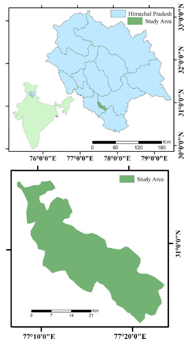
Fig. 1.
Study area in Himachal Pradesh, India.
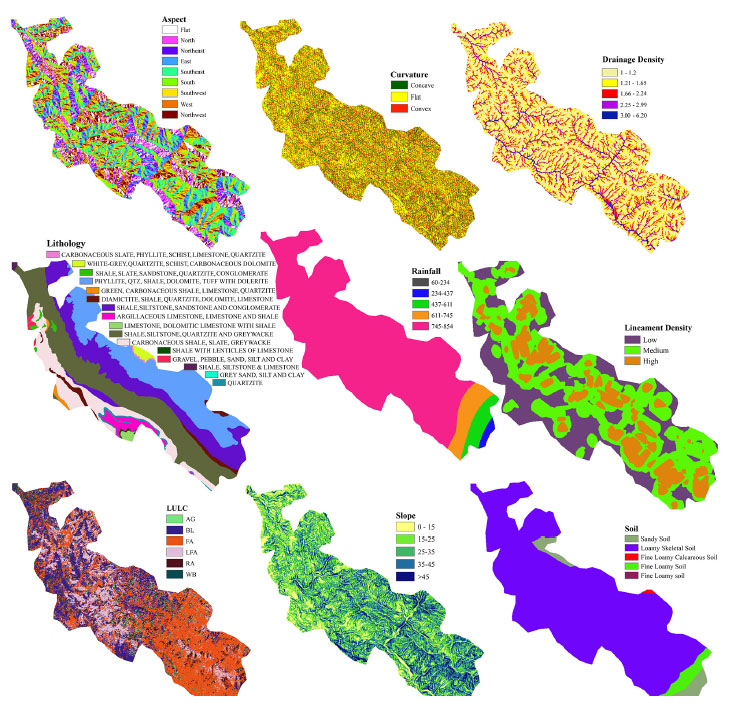
Fig. 2.
Thematic layers of causative factors: aspect, curvature, drainage density, lithology, rainfall, lineament density, LULC, slope and soil.
Table 1.
Numerical weights of AHP (CR – consistency ratio).
| Factors comparison | –1 | –2 | –3 | –4 | –5 | –6 | –7 | –8 | –9 | –10 | Normalised Eigen weight Wk |
|---|---|---|---|---|---|---|---|---|---|---|---|
| Slope | 1 | 0.2109 | |||||||||
| Aspect | 0.5 | 1 | 0.0672 | ||||||||
| Curvature | 0.33 | 7 | 1 | 0.0996 | |||||||
| Land use and land cover | 0.2 | 0.11 | 0.14 | 1 | 0.0368 | ||||||
| Lithology | 0.14 | 0.33 | 0.11 | 0.17 | 1 | 0.0187 | |||||
| Soil | 0.11 | 7 | 3 | 9 | 9 | 1 | 0.1631 | ||||
| Drainage density | 1 | 5 | 5 | 3 | 4 | 3 | 1 | 0.1889 | |||
| Lineament density | 0.33 | 1 | 7 | 5 | 9 | 0.14 | 0.2 | 1 | 0.1038 | ||
| Rainfall | 0.22 | 0.14 | 0.22 | 3 | 7 | 0.33 | 0.11 | 0.17 | 1 | 0.1065 | |
| CR = 0.76 | |||||||||||
| Comparison of factor classes | Wik | ||||||||||
| Slope (°) | |||||||||||
| (1) 0–<15 | 1 | 0.0405 | |||||||||
| (2) 15–<25 | 3 | 1 | 0.0887 | ||||||||
| (3) 25–<35 | 3 | 3 | 1 | 0.1483 | |||||||
| (4) 35–<45 | 5 | 3 | 3 | 1 | 0.2393 | ||||||
| (5) >45 | 7 | 5 | 5 | 7 | 1 | 0.4829 | |||||
| CR = 0.079 | |||||||||||
| Aspect | |||||||||||
| (1) Flat | 1 | 0.0423 | |||||||||
| (2) North | 2 | 1 | 0.0615 | ||||||||
| (3) Northeast | 0.32 | 0.2 | 1 | 0.0189 | |||||||
| (4) East | 0.15 | 0.5 | 0.33 | 1 | 0.0256 | ||||||
| (5) Southeast | 1 | 3 | 5 | 5 | 1 | 0.0852 | |||||
| (6) South | 3 | 5 | 7 | 3 | 5 | 1 | 0.2469 | ||||
| (7) Southwest | 5 | 2 | 7 | 5 | 7 | 0.15 | 1 | 0.1552 | |||
| (8) West | 0.2 | 0.13 | 1 | 0.33 | 0 | 0.5 | 0.11 | 1 | 0.0145 | ||
| (9) Northwest | 1 | 0.5 | 9 | 5 | 1 | 0.11 | 0.33 | 3 | 1 | 0.0642 | |
| (10) North | 7 | 5 | 7 | 7 | 3 | 1 | 5 | 7 | 9 | 1 | 0.2623 |
| CR = 0.89 | |||||||||||
| LULC | |||||||||||
| (1) Thickly vegetated forest area | 1 | 0.0681 | |||||||||
| (2) Populated flat land | 2 | 1 | 0.0864 | ||||||||
| (3) Less vegetated area | 2 | 2 | 1 | 0.1116 | |||||||
| (4) Moderately vegetated area | 3 | 3 | 4 | 1 | 0.2131 | ||||||
| (5) Barren land | 2 | 4 | 2 | 2 | 1 | 0.2081 | |||||
| (6) Water body | 3 | 3 | 3 | 3 | 3 | 1 | 0.3187 | ||||
| CR = 0.87 | |||||||||||
| Curvature | |||||||||||
| (1) Concave | 1 | 0.6763 | |||||||||
| (2) Flat | 0.13 | 1 | 0.0728 | ||||||||
| (3) Convex | 0.34 | 4 | 1 | 0.2507 | |||||||
| CR = 0.032 | |||||||||||
| Drainage density | |||||||||||
| (1) Low | 1 | 0.5644 | |||||||||
| (2) Medium | 0.5 | 1 | 0.549 | ||||||||
| (3) High | 0.33 | 0.33 | 1 | 0.3011 | |||||||
| CR = 0.05 | |||||||||||
| Soil | |||||||||||
| (1) Coarse loamy | 1 | 0.0854 | |||||||||
| (2) Fine loamy | 1 | 1 | 0.1357 | ||||||||
| (3) Loamy sand | 3 | 3 | 1 | 0.2568 | |||||||
| (4) Loamy soil | 9 | 2 | 3 | 1 | 0.5219 | ||||||
| CR = 0.07 | |||||||||||
| Lithology | |||||||||||
| (1) Quartzite | 1 | 0.0137 | |||||||||
| (2) Shale | 3 | 1 | 0.0284 | ||||||||
| (3) Siltstone, sandstone | 0.5 | 0.33 | 1 | 0.0254 | |||||||
| (4) Greywacke | 0.2 | 0.14 | 0.2 | 1 | 0.0692 | ||||||
| (5) Limestone | 0.33 | 0.13 | 0.12 | 1 | 1 | 0.0403 | |||||
| (6) Lenticles of limestone | 0.33 | 0.13 | 0.33 | 2 | 1 | 1 | 0.0327 | ||||
| (7) Quartzite | 2 | 7 | 9 | 7 | 3 | 7 | 1 | 0.0668 | |||
| (8) Shale, dolomite, tuff with dolerite | 0.12 | 0.33 | 0.5 | 7 | 3 | 3 | 0.14 | 1 | 7 | 0.0471 | |
| CR = 0.097 | |||||||||||
| Rainfall (mm) | |||||||||||
| (1) 60–234 | 1 | 0.0129 | |||||||||
| (2) 234–437 | 3 | 1 | 0.0156 | ||||||||
| (3) 437–611 | 0.33 | 0.5 | 1 | 0.0453 | |||||||
| (4) 611–745 | 0.12 | 0.14 | 0.5 | 1 | 0.0529 | ||||||
| (5) 745–854 | 0.5 | 9 | 0.14 | 7 | 1 | 0.0987 | |||||
| CR = 0.073 | |||||||||||
| Lineament density | |||||||||||
| (1) Low | 1 | 0.0399 | |||||||||
| (2) Medium | 2 | 1 | 0.0632 | ||||||||
| (3) High | 3 | 3 | 1 | 0.0746 | |||||||
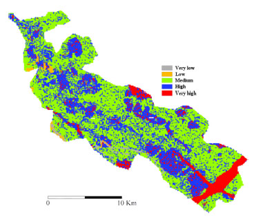
Fig. 3.
AHP model based Landslide Hazard Zonation map.
Table 2.
Numerical weights of certainty factor (CF).
| Causative factors | Categories | Value | Cell count | Landslide count | PPA | PPS | CF |
|---|---|---|---|---|---|---|---|
| Aspect | Flat | 1 | 22,655 | 17 | 0.001 | 0.0008 | –0.11 |
| North | 2 | 22,368 | 9 | 0.000 | 0.0008 | –0.52 | |
| Northeast | 3 | 18,085 | 23 | 0.001 | 0.0008 | 0.34 | |
| East | 4 | 22,260 | 32 | 0.001 | 0.0008 | 0.42 | |
| Southeast | 5 | 26,489 | 12 | 0.000 | 0.0008 | –0.46 | |
| South | 6 | 29,490 | 56 | 0.002 | 0.0008 | 0.56 | |
| Southwest | 7 | 31,371 | 33 | 0.001 | 0.0008 | 0.20 | |
| West | 8 | 28,629 | 4 | 0.000 | 0.0008 | –0.83 | |
| Northwest | 9 | 26,444 | 20 | 0.001 | 0.0008 | –0.10 | |
| North | 10 | 27,083 | 8 | 0.000 | 0.0008 | –0.65 | |
| Curvature | Concave | 1 | 43,901 | 27 | 0.001 | 0.0008 | –0.27 |
| Flat | 2 | 149,442 | 125 | 0.001 | 0.0008 | 0.00 | |
| Convex | 3 | 61,531 | 62 | 0.001 | 0.0008 | 0.20 | |
| Drainage density | Low | 1 | 39,566 | 53 | 0.001 | 0.0008 | 0.37 |
| Medium | 2 | 141,605 | 116 | 0.001 | 0.0008 | –0.02 | |
| High | 3 | 73,682 | 45 | 0.001 | 0.0008 | –0.27 | |
| Line density | Low | 1 | 78,363 | 43 | 0.001 | 0.0008 | 0.35 |
| Medium | 2 | 121,167 | 113 | 0.001 | 0.0008 | 0.10 | |
| High | 3 | 54,470 | 57 | 0.001 | 0.0008 | 0.00 | |
| Lithology | White-grey quartzite, schist and carbonaceous dolomite | 1 | 76,929 | 136 | 0.002 | 0.0008 | 0.53 |
| Shale, slate, sandstone, quartzite and conglomerate | 2 | 55,002 | 14 | 0.000 | 0.0008 | –0.69 | |
| Shale, siltstone, sandstone and conglomerate | 3 | 1090 | 42 | 0.039 | 0.0008 | 0.98 | |
| Shale, siltstone, quartzite and greywacke | 4 | 1451 | 17 | 0.012 | 0.0008 | 0.93 | |
| Shale, siltstone and limestone | 5 | 66,064 | 3 | 0.000 | 0.0008 | ||
| Shale with lenticles of limestone | 6 | 25 | 0 | 0.000 | 0.0008 | –1.00 | |
| Quartzite | 7 | 499 | 0 | 0.000 | 0.0008 | –1.00 | |
| Phyllite, quartzite, shale, dolomite and tuff with dolerite | 8 | 1456 | 0 | 0.000 | 0.0008 | –1.00 | |
| Limestone and dolomitic limestone with shale | 9 | 31,718 | 0 | 0.000 | 0.0008 | –1.00 | |
| Grey sand, silt and clay | 10 | 6376 | 0 | 0.000 | 0.0008 | –1.00 | |
| Green, carbonaceous shale, limestone and quartzite | 11 | 816 | 0 | 0.000 | 0.0008 | –1.00 | |
| Diamictite, shale, quartzite, dolomite | 12 | 2200 | 0 | 0.000 | 0.0008 | –1.00 | |
| Carbonaceous slate, phyllite, schist, lst. and quartzite | 13 | 437 | 0 | 0.000 | 0.0008 | –1.00 | |
| Carbonaceous shale, slate and greywacke | 14 | 6464 | 0 | 0.000 | 0.0008 | –1.00 | |
| Argillaceous limestone, limestone and shale | 15 | 4186 | 0 | 0.000 | 0.0008 | –1.00 | |
| Soil | Coarse loamy | 1 | 13,074 | 138 | 0.011 | 0.0008 | 0.92 |
| Fine loamy | 2 | 232,569 | 75 | 0.000 | 0.0008 | –0.62 | |
| Loamy sand | 3 | 506 | 1 | 0.002 | 0.0008 | 0.58 | |
| Loamy | 4 | 8706 | 0 | 0.000 | 0.0000 | ||
| Slope | 0–15° | 1 | 39,010 | 9 | 0.000 | 0.0008 | –0.73 |
| 15–25° | 2 | 63,822 | 30 | 0.000 | 0.0008 | –0.44 | |
| 25–35° | 3 | 71,048 | 51 | 0.001 | 0.0008 | –0.15 | |
| 35–45° | 4 | 57,153 | 62 | 0.001 | 0.0008 | 0.23 | |
| >45° | 5 | 23,841 | 62 | 0.003 | 0.0008 | ||
| Rainfall | 60–234 mm | 1 | 32,135 | 138 | 0.004 | 0.0002 | 0.96 |
| 234–437 mm | 2 | 25,246 | 38 | 0.002 | 0.0002 | 0.87 | |
| 437–611 mm | 3 | 32,912 | 34 | 0.001 | 0.0002 | 0.81 | |
| 611–745 mm | 4 | 137,645 | 3 | 0.000 | 0.0002 | –7.84 | |
| 745–854 mm | 5 | 878,021 | 0 | 0.000 | 0.0002 | –1.00 | |
| LULC | Ag | 1 | 10,952 | 152 | 0.014 | 0.0008 | 0.94 |
| BL | 2 | 66,546 | 16 | 0.000 | 0.0008 | –0.71 | |
| FA | 3 | 116,814 | 11 | 0.000 | 0.0008 | –7.88 | |
| LFA | 4 | 38,384 | 13 | 0.000 | 0.0008 | –0.59 | |
| RA | 5 | 17,666 | 2 | 0.000 | 0.0008 | –0.86 | |
| WB | 6 | 4534 | 19 | 0.004 | 0.0008 | 0.80 |
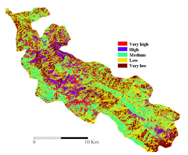
Fig. 4.
Certainty Factor Model based Landslide Hazard Zonation map.
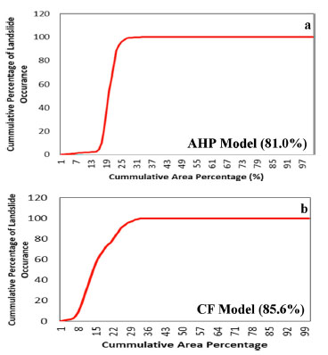
Fig. 5.
Area under curve validation graphs for AHP (a) and CF (b) models.