
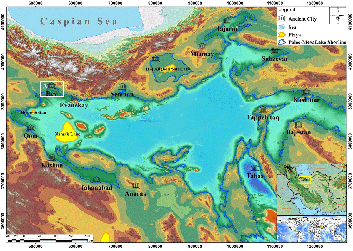
Figure 1
The study area (Box A) is located on the southern slopes of the central Alborz Mountains. As can be seen, the ancient lake (Blue line) was vast and covered 137000 km2 of northern Iran (at an altitude of 1000 m above sea level). The city of Rey, one of the ancient cities of Iran, is located on the northwest coast of this lake. Note to the distribution of other ancient cities on the shores of the Paleo lake. The Digital Elevation Model (DEM) with an accuracy of 10 m was taken from the United States Geological Survey (USGS) to provide the map background.
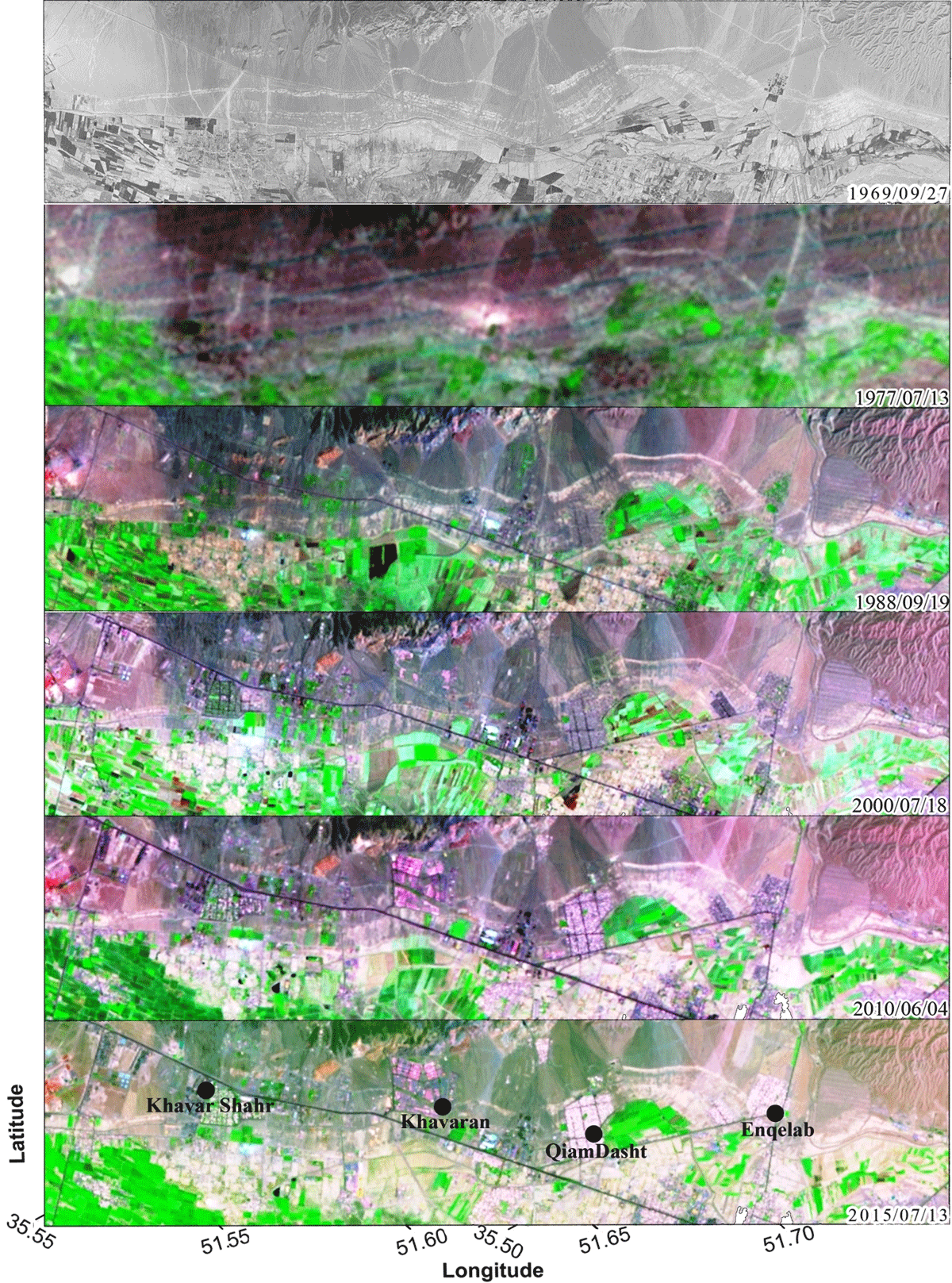
Figure 2
Urbanism development and its effect on the shoreline traces (white color bands). Upper image is of SDclass satellite and others are Landsat series. (Cadre D in Figure 3).

Figure 3
The position of the scarps of the ancient lakeshore (white stripes) in the southeastern region of Tehran is shown on the 1969 satellite images. The scarps are all horizontal and parallel to the topographic contours. In the area of Rey plain, where agriculture is being conducted adjacent to human communities, the number of visible scarps is much lower than in more marginal areas, such as the eastern part of the study area (east of the Parchin city). Note the high density of the Qanats in the southern region of Rey. In the lower part of the image, the three areas where the most evidence can be seen are considered for further study.
Table 1
The information on the paleo shorelines in SE Tehran.
| PALEO SHORELINES | ALTITUDE (M) | LENGTH (KM) | HEIGHT(M) | LOCATION | |
|---|---|---|---|---|---|
| PS-1 | 1100 | 16 | 12 | North of Rey | |
| PS-2 | 1050 | 24 & 21 & | 13 | Parchin to Khavarshahr cities, & South of Rey | |
| PS-2-a | 1050 | 3 | 3 | ||
| PS-2-b | 1045 | 14 | 3 | ||
| PS-2-c | 1040 | 4 & 3 | 8 | ||
| PS-2-d | 1030 | 7 & 4 | 5 | ||
| PS-3 | 1010 | 41 | 15 | South of Kahrizak | |
| PS-3-a | 950 | 8 | 8 | West of Varamin | |
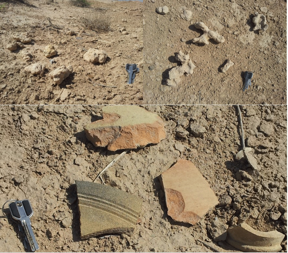
Figure 4
Samples collected from the Kahrizak scarp. Worm tubes are abundant in the samples. The dimensions of these holes range from 5 to 50 mm showing the variety in the size and age of the worms during the life of the lake. Broken pieces of the ancient pottery can be seen abundantly on the top of the scarp (the key is 6 cm long and is placed as a scale).
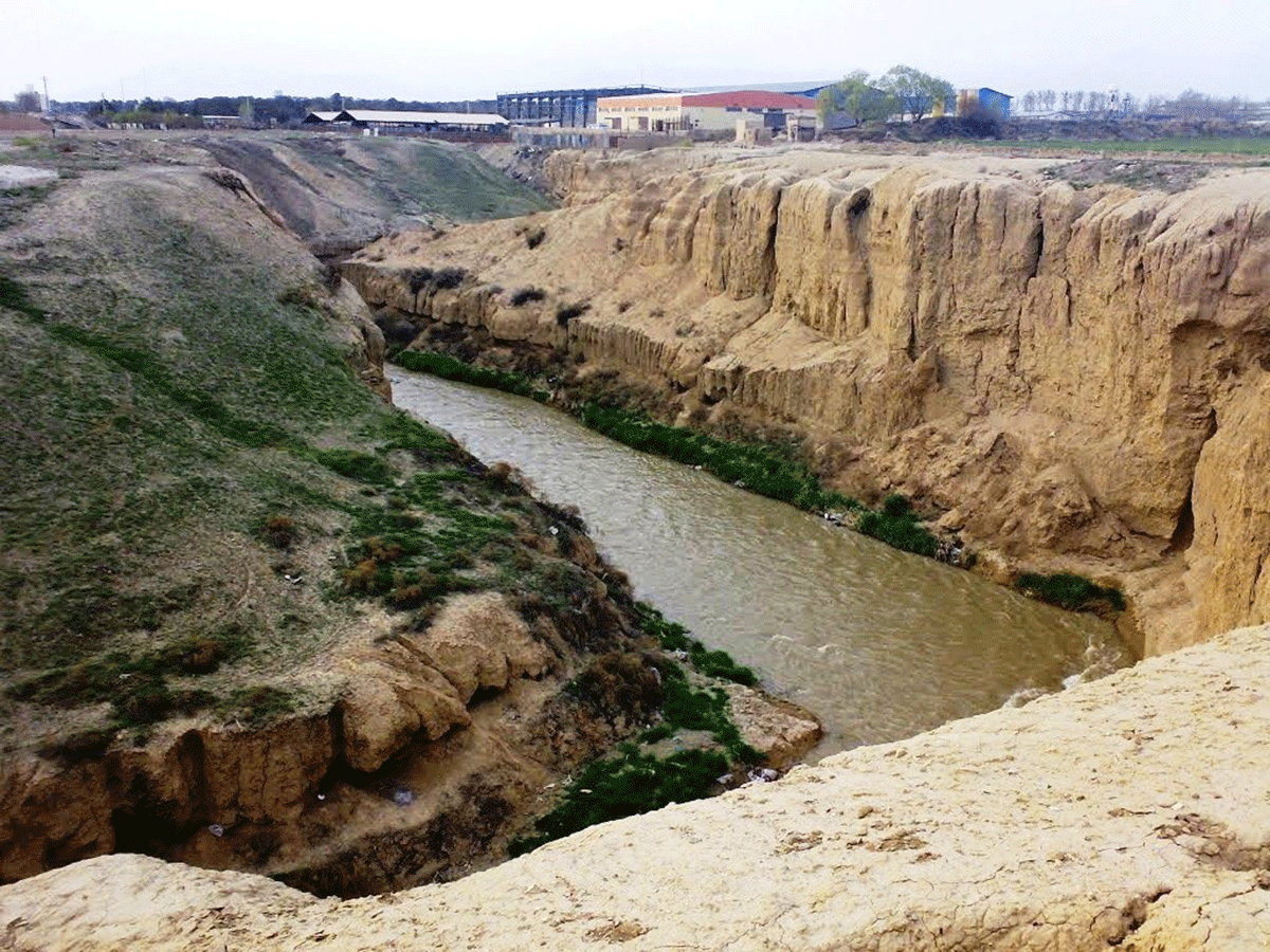
Figure 5
The more than eight meter deep channel of the Kan River, is incised into lake sediments (1080 m above sea level) south of Chardange city (South Rey scarp). The white fold line shows the boundary of light-colored lake sediments with older units (northward view). They are completely horizontal between the layers with light to dark cream colors in this profile. The river trench is almost perpendicular to the shoreline. The thickness of the sediments increases by traversing from north to south. Sedimentary units suddenly disappear at the edge of the scarp. (Box A1 in Figure 3).
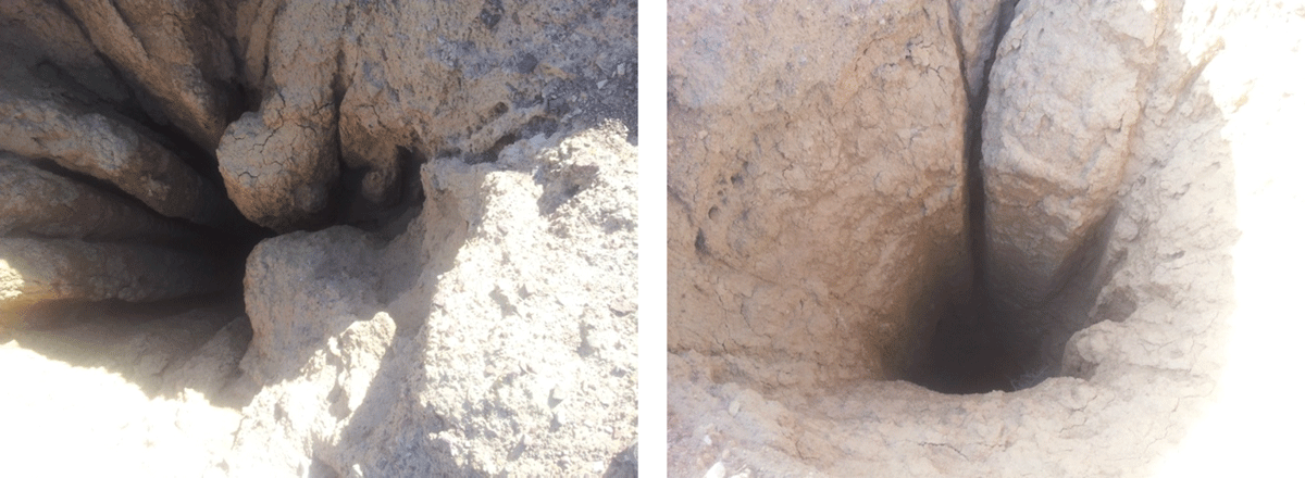
Figure 6
Qanat wells near Khavarshahr with 2 m diameter and about 12 m depth, on the PS2-d scarp. The placement of lake sedimentary layers on high-permeability sediments (Series B) has caused the subsurface water to flow beneath these sediments. The ancient people passed through impenetrable units and built the horizontal channel of the Qanat between these two sedimentary units by digging the qanat to reach the lower layer. Most of these wells and qanats have collapsed and been blocked due to subsurface erosion of tunnels and subsequent qanat collapse. Qanats have now been OSL dated to about 4,000 years BP. They provide a lower limit bracketing date for the lake sediments.
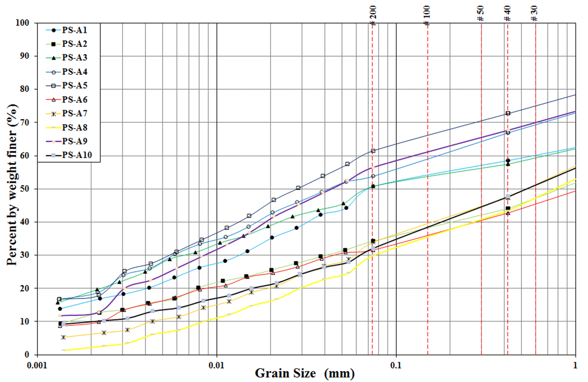
Figure 7
Granulation test of the sedimentary samples in the study area. The mesh size used for granulation is shown at the top of the chart. The second part of sediments that was smaller than mesh size of 200 was determined by the hydrometric test., i.e., hydrometer analysis.

Figure 8
Test results regarding determining the plasticity of sedimentary samples that indicate the CL range. Such soil has very low permeability.
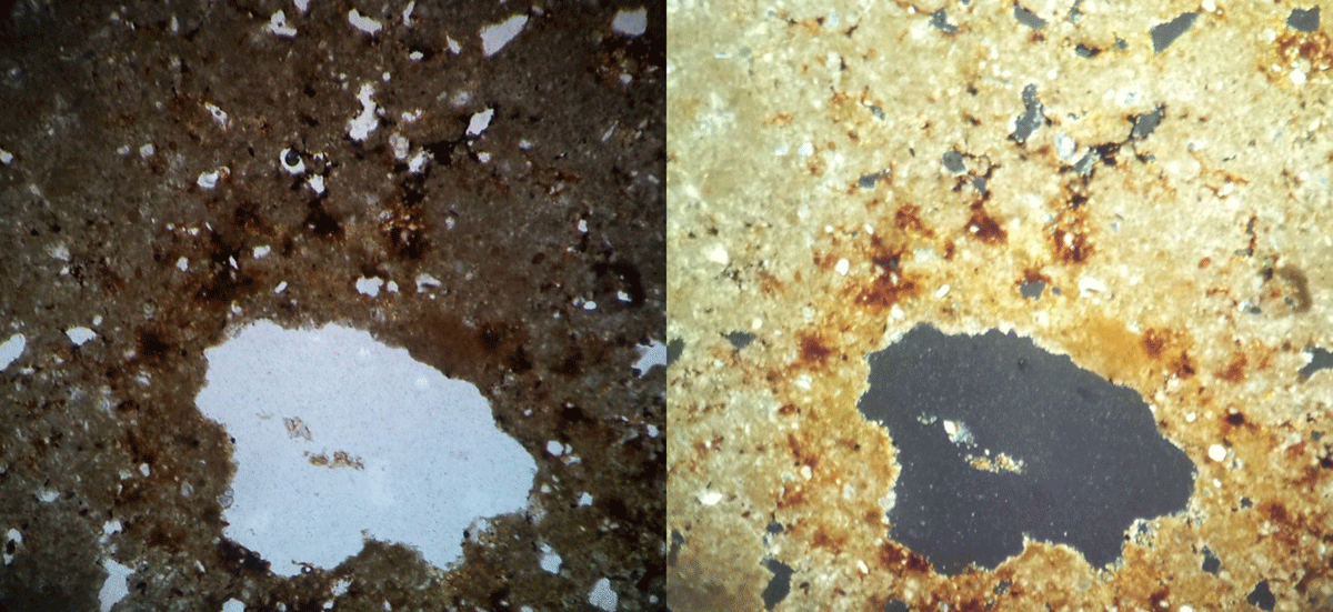
Figure 9
Micrograph related to the Rey scarp (PS-A9). The relatively thick clay skin under the plain-polarized and crossed polarized lights. Brown spots in lower part of the image show the presence of iron oxide on the drilled edge caused by the worms.