
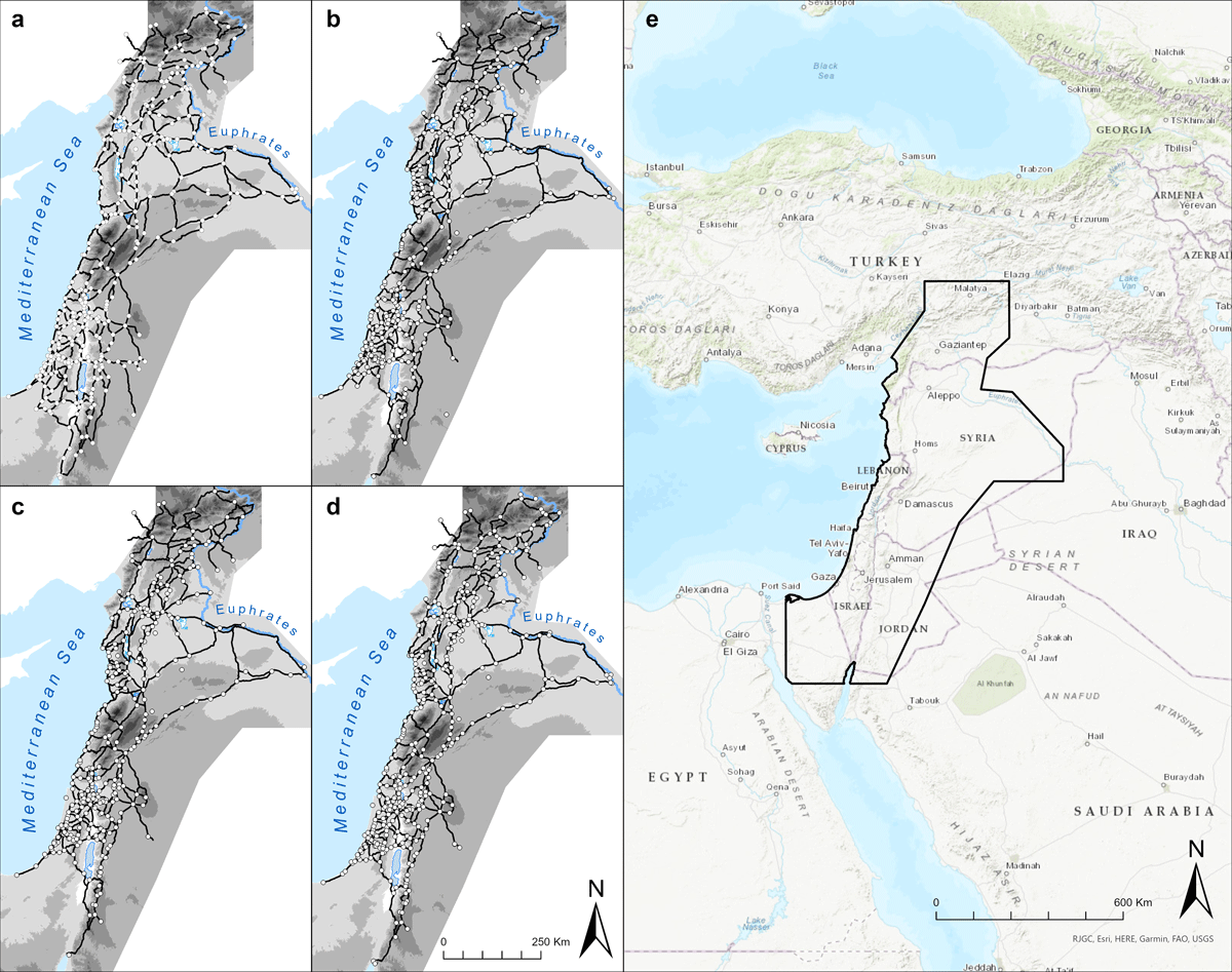
Figure 1
Map of the study region and digitised road networks. a) Early Islamic period, b) Middle Islamic period, c) Early Mamluk period, d) Late Mamluk period, e) Study region (marked in black outline) in its geographical context. © Adam Pažout.
Table 1
Summary statistics of Segment certainty and Road certainty categories of the road dataset by periods.
| EARLY ISLAMIC | MIDDLE ISLAMIC | EARLY MAMLUK | LATE MAMLUK | |||||
|---|---|---|---|---|---|---|---|---|
| SEGMENT CERTAINTY | ||||||||
| LENGTH (km) | PERCENTAGE | LENGTH (km) | PERCENTAGE | LENGTH (km) | PERCENTAGE | LENGTH (km) | PERCENTAGE | |
| Certain | 1,622.8 | 13.2% | 1,331.9 | 11.3% | 1,339.3 | 11.6% | 1,333.6 | 11.5% |
| Conjectured | 8,412.5 | 68.4% | 9,417.8 | 79.7% | 9,436.4 | 82.1% | 9,614.5 | 82.6% |
| Hypothetical | 2,227.2 | 18.4% | 1,065.2 | 9% | 716.1 | 6.3% | 685.4 | 5.9% |
| ROAD CERTAINTY | ||||||||
| LENGTH (km) | PERCENTAGE | LENGTH (km) | PERCENTAGE | LENGTH (km) | PERCENTAGE | LENGTH (km) | PERCENTAGE | |
| High | 7,656.4 | 62.3% | 7,515.9 | 63.6% | 7,957.5 | 69.2% | 8,104.1 | 69.7% |
| Medium | 1,650.1 | 24.3% | 4,197.7 | 35.5% | 3,500.4 | 30.5% | 3,495.5 | 30% |
| Low | 4,441.5 | 13.4% | 101.3 | 0.9% | 33.8 | 0.3% | 33.8 | 0.3% |
Table 2
Periodisation and terminology used in the dataset.
| PERIODISATION USED | DATING | DYNASTY/OTHER TERMINOLOGY |
|---|---|---|
| Early Islamic | 650–950 CE | Umayyad, Abbasid |
| Middle Islamic | 950–1250 CE | Fatimid, Middle Byzantine, Seljuk, Crusader, Ayyubid |
| Early Mamluk | 1250–1350 CE | Mamluk, Middle Islamic |
| Late Mamluk | 1350–1517 CE | Mamluk, Middle Islamic |
Table 3
Summary statistics of the dataset.
| PERIOD | ROAD LENGTH (km) | NUMBER OF SITES |
|---|---|---|
| Early Islamic | 12,262.5 | 361 |
| Middle Islamic | 11,814.9 | 409 |
| Early Mamluk | 11,491.8 | 429 |
| Late Mamluk | 11,633.5 | 443 |
Table 4
Data structure of the _roads files.
| FIELD NAME | MEANING | TYPE | DESCRIPTION |
|---|---|---|---|
| Id | Id | integer (Long Integer) | Unique numerical identifier |
| name | name | string (text) | Name of the road segment, typically in the form ‘Start point-End point’ using Medieval or modern names depending on whether the Medieval name is known. Arabic forms are preferred, English forms that are commonly used (Jerusalem, Damascus, etc.) are employed |
| type | type | string (text) | Type of the road segment, values: ‘Main Road’ and ‘Secondary Road’ |
| typeCode | type code | integer (Long Integer) | Road type numerical code, values: 2 = ‘Main Road’ and 1 = ‘Secondary Road’ |
| itinerary | itinerary | string (text) | Name of the known itinerary associated with the road segment, e.g., ‘Hajj Route’, ‘Barid’ etc. |
| source | source | string (text) | Medieval source that (probably) references the road segment, short reference in the form ‘Name Page Number’ of the standard primary edition or translation (see bibliography.md file for the full reference) |
| biblio | bibliography | string (text) | Reference to a secondary literature that was used to identify, localise, and digitise the road segment. Short reference in the form ‘Name Year’ (see bibliography.md file for full reference) |
| segmentCer | segment certainty | string (text) | Spatial accuracy of the digitisation of the road segment. Values: ‘Certain’ (+/– 50 m in mountainous terrain, +/–200 in flat terrain), ‘Conjectured’, ‘Hypothetical’ (mostly unfixed desert routes) |
| roadCer | road certainty | string (text) | Certainty of the existence of the road segment based on the available primary and secondary sources. Values: ‘High’ (primary and secondary sources, or good archaeological/historical-geographical secondary literature), ‘Medium’ (based on archaeological and historical-geographical secondary literature), ‘Low’ (based only on settlement context or archaeological secondary literature) |
| geoLength | geodesic length | integer (32-bit Float) | Geodesic length of the road segment in meters |
| citation | citation | string (text) | Author of the digitisation |
Table 5
Data structure of the _sites files.
| FIELD NAME | MEANING | TYPE | DESCRIPTION |
|---|---|---|---|
| Id | Id | integer (Long Integer) | Unique numerical identifier |
| name | name | string (text) | Medieval name of the site. Arabic forms are preferred, in some cases Frankish/Latin names are used |
| modernName | modern name | string (text) | Modern name of the site |
| type | type | string (text) | Type of the site. Values: ‘city’, ‘settlement’, ‘station’, ‘fort’, ‘place’, ‘sanctuary’, ‘bridge’ |
| minDate | minimum date | string (text) | Earliest date the site can be dated to. For unknown 9999 is used |
| maxDate | maximum date | string (text) | Date of the destruction/abandonment of the site. For unknown or continuous activity until the present 9999 is used |
| umayyad | Umayyad period | string (text) | Whether site exists in given period. Value: ‘yes’, ‘no’, ‘unknown’, ‘possible’ |
| abbasid | Abbasid period | string (text) | Whether site exists in given period. Value: ‘yes’, ‘no’, ‘unknown’, ‘possible’ |
| fatimid | Fatimid/Middle Byzantine period | string (text) | Whether site exists in given period. Value: ‘yes’, ‘no’, ‘unknown’, ‘possible’ |
| ayyubidCru | Ayyubid-Crusader period | string (text) | Whether site exists in given period. Value: ‘yes’, ‘no’, ‘unknown’, ‘possible’ |
| mamluk | Mamluk period | string (text) | Whether site exists in given period. Value: ‘yes’, ‘no’, ‘unknown’, ‘possible’ |
| citation | citation | string (text) | Author of the digitisation |
| biblio | bibliography | string (text) | Reference to a secondary literature that was used to identify, localise, and digitise the site. Short reference in the form ‘Name Year’ (see bibliography.md file for the full reference) |