
1. Introduction
Despite the consensus on the need for a shared repository for data associated with ironworking (Charlton 2015), no global reference database has been established in the field of iron archaeometallurgy until now. However, a similar initiative has been established by a closely related scientific community focused in amalgamating lead isotope data from non-ferrous metalworking (copper alloys or lead/silver metallurgy), along with metadata geo-locations, dating and chemical data. This initiative, known as TerraLID, was launched in 2009 and is now accessible via a web portal for common use (Klein et al. 2022). When successfully implemented, such iniatives can provide significant benefits to the research community. The ’Chimie en PaléoSidérurgie’ (CHIPS) database is intended to play such a role for archaeometallurgists of iron. Several members of the Institut de Recherche sur les Archéomatériaux (IRAMAT-CNRS) have developed a database management system designed to enable researchers to easily select geolocated reference data (Huet & Disser n.d.). Along with a dashboard (Huet & Disser n.d.), a dedicated interface is currently under development to facilitate queries based on categorical criteria (such as chronology or typology) or spatial data (available at the CHIPS – GEO platform; Costa & Disser n.d.). While this interface is currently only available in French, an English version is in progress. Particular attention has been given to documenting analytical metadata—such as analytical conditions and laboratory information—which is critical for assessing data quality. Ultimately, these two databases (TerraLID and CHIPS), built on shared ontologies, can form an essential digital reference framework for research in archaeometallurgy. Additionally, the CHIPS team is collaborating closely with colleagues developing a complementary database focused on structuring contextual information. This includes advanced normative descriptions of archaeological materials and precise documentation of smelting technologies. Both databases will eventually be integrated into a broader information system, enabling enhanced descriptions of contextual and chemical data.
This article aims to detail the design choices behind the CHIPS database data model, including the collation of heterogeneous datasets and the creation of queryable attribute descriptors. While some features of the information system are still under development, the database is already functional for basic queries. It is primarily populated with previously published data, and a growing user community is forming around this tool, which has the potential to become an indispensable reference for future research in iron archaeometallurgy.
2. Background
The study of chaînes opératoires and the circulation of materials—primarily ores and metal products—is a central focus of research in iron archaeometallurgy. These research areas heavily depend on the analysis of chemical data. Indeed, the chemical composition of products and waste associated with iron- and steelmaking activities allows researchers, to a significant extent, to reconstruct the physicochemical conditions under which metallurgical operations—such as ore preparation, direct smelting, and primary and secondary smithing—took place. This, in turn, provides deeper insights into the practices of ancient metallurgists (Blakelock et al. 2009; Charlton et al. 2010; Dillmann & L’Héritier 2007; Serneels 1993; Serneels & Crew 1997). These studies are essential for understanding the history of techniques from both material and socio-economic perspectives, including the physicochemical processes involved. Furthermore, recent research has demonstrated the feasibility of establishing chemical links between extracted ores, the workshops where they were smelted, and the metal products produced in those same workshops. These studies have assessed the potential of numerous chemical markers for this purpose. (Charlton et al. 2012; Dillmann et al. 2017; Disser et al. 2016; Milot et al. 2016; Pagès et al. 2022; Stepanov et al. 2020; Żabiński et al. 2020). These approaches enable the partial reconstruction of long-lost socio-economic systems by analyzing the circulation of materials, including trade routes and distances.
For the past 40 years, researchers in ancient metallurgy have been compiling chemical data to support their work. However, this documentation is widely scattered across various publication formats—printed sheets, PDF or Word tables, spreadsheets, and raw data files accompanied by scripts for statistical analysis. Furthermore, the analytical instruments used to collect this data rely on different physical principles (e.g., X-ray fluorescence spectroscopy, mass spectrometry, neutron activation), each with distinct characteristics and performance metrics, such as LoD, measurement errors, and signal resolution.
Additionally, archaeometallurgists come from diverse disciplinary backgrounds—geochemistry, materials science, and archaeology—which influences how they represent data. Authors’ choices vary, including stoichiometric representations or quantification in elemental or oxide forms. This heterogeneity poses significant challenges for collating data for collective use. For individual researchers, collecting, filtering, and merging datasets to build reference data is an extremely time-consuming process. As a result, a single project is unlikely to fully exploit the potential of its generated data—potential that may only become apparent in hindsight or when compared with new datasets.This is precisely where the semantic web, linked open data (LOD), and the FAIR principles (Findable, Accessible, Interoperable, Reusable) come into play. These frameworks aim to standardize data, creating opportunities for new insights and innovative analytical methods.
3. Design of the CHIPS database
The design of the CHIPS database initially began as an attempt to create a tabular repository. However, the need to structure the information as a relational database quickly became evident to ensure data integrity, consistency, longevity, and interoperability. As a result, it was decided to develop the database using PostgreSQL. Among open-source database management systems, PostgreSQL is the closest alternative to Oracle, the most widely used system in the information systems sector. In addition to its SQL capabilities, this choice was primarily driven by the ability to leverage PostGIS, its spatial extension. PostGIS provides the necessary functionalities for managing spatial data, including the use of spatial indexes and geoprocessing tools. The data is structured around four main tables, which respectively document the archaeological context of discovery (‘contexts’), the archaeological material (‘samples’), the analysis carried out (‘analyses’) and the associated measurement errors (‘measurement errors’). These four tables will successively be described, along with the parent tables that document each of them. The simplified Entity-Relationship Diagram (ERD) is shown in Figure 1.
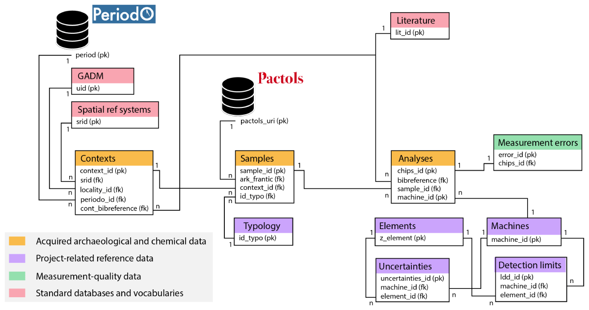
Figure 1
Simplified ERD of the CHIPS DB.
Tables and their columns are described below and in a dynamic table hosted on the CHIPS database website (https://iramat.github.io/chips/docs/documentation/#tables-and-fields).
3.1. ‘Contexts’ table
It is composed of 14 fields (primary key: ‘context_id’; Table 1). Its purpose is to identify and geolocate archaeological contexts, link them to geoadministrative data, and define their chronology. A context is classified as either a locus, a phase of occupation or activity, or a stratigraphic unit. Multiple contexts may belong to the same archaeological site. For instance, metallurgical sites often contain heaps of slag that were successively piled up but remain stratigraphically distinct. In such cases, each heap is treated as an individual context, with its name recorded in the ‘context_name’ field. The archaeological site of which these heaps are part is registered for each single context in the ‘place_name’ field. An additional field ‘context_type_id’ used as a foreign key allows a more precise description of the context: locus, phase, stratigraphical unit, etc. A ‘context_type’ field with a value constraint is used to express the type of context. The ‘locality_id’ field acts as a foreign key to the ‘gadm’ parent table. The Global Administrative Areas dataset (GADM), published online by U.C. Davis, includes approximately 400,000 administrative entities worldwide. These entities are documented across five hierarchical levels, ranging from country to municipality (GADM n.d.). Four fields provide spatial information. The ‘srid’ field is documented by the ‘spatial_ref_sys’ table associated with the PostGIS extension, and is used to interpret the coordinates in the ‘long’ and ‘lat’ fields (decimal degrees or projected coordinates). In the source documents, the geographic coordinates are expressed in a variety of projection systems, depending on the location of the study area or national administrative recommendations. For France, for example, coordinates are often published in the Lambert-93 system (EPSG:2154; International Organization for Standardization 2019). The Boolean ‘centroid’ field indicates whether the coordinates are those of the site, or those of the administrative entity’s centroid. Three fields are associated with chronology. The field ‘edtf’ gathers EDTF (ISO 8601-2:2019) temporal information on the different contexts allowing, among others, to record chronology uncertainities (‘?’ mark) and approximations (‘~’ mark). Along with the ‘edtf’ field, the ‘periodo_id’ field links the chronological data to the Periodo gazetteer to ease the definition of the periods of activity. The last field, ‘points’, is made up of objects of type GEOGRAPHY, produced using the PostGIS ST_MakePoint geospatial function. A field ‘cont_bibreference’ is used as a foreign key to the ‘literature’ table. It allows to get access to the documentation related to archaeological data and excavation, as this kind of information is often summarized in the publications dealing with chemical data.
Table 1
View created from the ‘contexts’ table, showing 13 examples of contexts.
| context_id | context_name | place_name | srid | longitude | latitude | centroid | context_type | edtf | points | key_periodo | key_periodo2 | locality_id |
|---|---|---|---|---|---|---|---|---|---|---|---|---|
| INTEGER PRIMARY KEY | TEXT | TEXT | INTEGER FOREIGN KEY | NUMERIC | NUMERIC | BOOLEAN | TEXT | TEXT | GEOMETRY | TEXT | TEXT | INTEGERFOREIGN KEY |
| 62 | Boeng Kroam location 1 (BK1) | Boeng Kroam | 4326 | 105.168 | 11.0619 | true | locus | 1400~/1500~ | 0101000020E6100000986E1283C04A5A40AB3E575BB11F2640 | https://n2t.net/ark:/99152/p02chr49ctv | 238603 | |
| 63 | Boeng Kroam location 1 (BK2) | Boeng Kroam | 4326 | 105.168 | 11.0619 | true | locus | 1450~/1750~ | 0101000020E6100000986E1283C04A5A40AB3E575BB11F2640 | https://n2t.net/ark:/99152/p02chr49ctv | https://n2t.net/ark:/99152/p02chr478fd | 238603 |
| 399 | Chanoi 1 | Chanoi | 4326 | 4.78407 | 47.75319 | true | locus | -0025~/0450~ | 0101000020E61000005019FF3EE32213404DD6A88768E04740 | https://n2t.net/ark:/99152/p02chr4964n | 71481 | |
| 400 | Chanoi 2 | Chanoi | 4326 | 4.78407 | 47.75319 | true | locus | 1316~/1648~ | 0101000020E61000005019FF3EE32213404DD6A88768E04740 | https://n2t.net/ark:/99152/p02chr49ctv | https://n2t.net/ark:/99152/p02chr478fd | 71481 |
| 364 | Chemin des Combes | Chemin des Combes | 4326 | 6.36186 | 47.35265 | true | locus | 0542/0684 | 0101000020E610000018EC866D8B7219409A779CA223AD4740 | https://n2t.net/ark:/99152/p02chr49bbg | 75236 | |
| 397 | L’Abîme US 102 | L’Abîme | 4326 | 3.2669 | 47.4717 | false | stratigraphic unit | 1295/1401 | 0101000020E6100000516B9A779C220A40F8C264AA60BC4740 | https://n2t.net/ark:/99152/p02chr49ctv | 73943 | |
| 398 | L’Abîme US 104 | L’Abîme | 4326 | 3.2669 | 47.4717 | false | stratigraphic unit | 0066/0222 | 0101000020E6100000516B9A779C220A40F8C264AA60BC4740 | https://n2t.net/ark:/99152/p02chr4847s | 73943 | |
| 76 | Chêne Saint-Amand HMA | Chêne Saint-Amand | 4326 | 4.9721 | 48.625 | false | sequence | 0700~/0900~ | 0101000020E610000033C4B12E6EE313400000000000504840 | https://n2t.net/ark:/99152/p02chr4scv9 | 62995 | |
| 77 | Chêne Saint-Amand MA | Chêne Saint-Amand | 4326 | 4.9678 | 48.6267 | false | sequence | 1000~/1200~ | 0101000020E6100000744694F606DF13409C33A2B437504840 | https://n2t.net/ark:/99152/p02chr458g8 | 62995 | |
| 1593 | Chestnut Park | Chestnut Park | 4326 | -2.3711 | 51.6261 | false | locus | 0015?~/0200?~ | 0101000020E6100000645DDC4603F802C04703780B24D04940 | https://n2t.net/ark:/99152/p0kh9ds8p8k | https://n2t.net/ark:/99152/p0kh9ds9nsj | 43238 |
| 1490 | Combe Tabeillon | Combe Tabeillon | 4326 | 7.1563 | 47.3115 | false | locus | 1000?~/1300?~ | 0101000020E61000008E75711B0DA01C401D5A643BDFA74740 | https://n2t.net/ark:/99152/p02chr458g8 | 339128 | |
| 1492 | Combe Tabeillon 1 | Combe Tabeillon | 4326 | 7.1374 | 47.302 | false | locus | 0101000020E6100000B1E1E995B28C1C402DB29DEFA7A64740 | 339128 | |||
| 1493 | Combe Tabeillon 2 | Combe Tabeillon | 4326 | 7.1381 | 47.3019 | false | locus | 0900?~/1200?~ | 0101000020E6100000764F1E166A8D1C40CA54C1A8A4A64740 | https://n2t.net/ark:/99152/p02chr4zc8c | 339128 |
3.2. ‘Samples’ table
The ‘samples’ table is composed of 5 fields (Table 2). Two fields identify the sample: ‘sample_id’ is the table’s primary key and ‘sample_name’ is the identifier given by the archaeologist during the post-excavation study of the material, or a code given when the sample was taken. ‘site_id’ is the foreign key referencing the context in which the artefacts were found. A ‘comment’ field allows a more precise yet less standardised description of the sample if needed. The ‘id_typo’ field is filled in by the ‘typology’ table, the aim of which is to obtain information on the artefacts as precisely as possible, while ensuring the effectiveness of categorical queries.
Table 2
View created from the ‘samples’ table, showing 11 sample examples.
| sample_id | sample_name | context_id | typology_id | COMMENTS |
|---|---|---|---|---|
| INTEGER PRIMARY KEY | TEXT | INTEGER FOREIGN KEY | INTEGER FOREIGN KEY | TEXT |
| 6797 | VG_1b | 1744 | 24 | Microlammellar hematite |
| 6805 | TN-2 | 1746 | 24 | Lamellar/micaceous hematite with pyrite |
| 6813 | 6997 | 1748 | 24 | Massive goethite with calcite |
| 6795 | VIG_M | 1742 | 24 | Lamellar/micaceous hematite |
| 6819 | 4526/b | 1751 | 24 | Hematite-bearing schist |
| 6809 | TN-9 | 1746 | 24 | Micaceous hematite |
| 6836 | 11007 | 1764 | 24 | Micaceous hematite |
| 6824 | 901 | 1756 | 24 | hematite with calcite |
| 6812 | 2914 | 1748 | 24 | Brown–reddish massive goethite |
| 6838 | 16259 | 1765 | 24 | Fibrous-radiated hematite |
| 6814 | 7231 | 1749 | 24 | Micaceous hematite (Montomoli shaft) |
The ‘typology’ table therefore has a hierarchical structure with five levels (Table 3). The first level ‘process’ corresponds to the ironmaking process in question, i.e. the direct or indirect process. Establishing this difference is fundamental, since the chaînes opératoires and physico-chemical processes involved are radically different. The data associated with either process cannot therefore be compared directly. The ‘context’ field specifies whether the material was collected in a geological (i.e., extra-site, for ore or earth), archaeological (i.e., intra-site) or experimental context. The ‘material’ field indicates the nature of the artefact: slag, earth, ore, rock, etc. The ‘category’ field is the first level of qualification for the material. For the material slag, this qualifier could be ore smelting or metal forging, for example. The ‘subcategory’ field is the second level of qualification, which can give even more details about the material. For a smelting slag, this second level can be used to determine whether the slag is moulded at the bottom of the furnace, or whether it has flowed out of the furnace. This level of precision is necessary to accurately interpret the archaeological context and the associated chemical data. A last field ‘ark_frantic’ references each typological entity with an ARK permanent identifier linked to the Pactols thesaurus. This aspect will be further developed in section 4.1.
Table 3
View created from the ‘typology’ table, showing 11 examples of types.
| typology_id | process | context | material | category | subcategory | ark_frantic_uri |
|---|---|---|---|---|---|---|
| INTEGER PRIMARY KEY | TEXT | TEXT | TEXT | TEXT | TEXT | TEXT |
| 161 | Indirect | Experimental | Metal | Cast iron | NULL | https://ark.frantiq.fr/ark:/26678/pcrtTcvLDTNT86 |
| 190 | Direct | Archaeological | Earth | Molten | NULL | https://ark.frantiq.fr/ark:/26678/pcrt5bIL1UtwcT |
| 15 | Direct | Archaeological | Slag | Smithing | Hearth bottom | https://ark.frantiq.fr/ark:/26678/pcrtfvIQbnsSeS |
| 16 | Direct | Experimental | Slag | Smithing | Hearth bottom | https://ark.frantiq.fr/ark:/26678/pcrtfvIQbnsSeS |
| 3 | Direct | Archaeological | Slag | Smelting | NULL | https://ark.frantiq.fr/ark:/26678/pcrtzh0WTynBny |
| 24 | Unknown | Geological | Ore | Smelting | NULL | https://ark.frantiq.fr/ark:/26678/pcrt5bIL1UtwcT |
| 5 | Direct | Archaeological | Slag | Smelting | Tap slag | https://ark.frantiq.fr/ark:/26678/pcrtzh0WTynBny |
| 10 | Direct | Experimental | Slag | Smelting | Slag block | https://ark.frantiq.fr/ark:/26678/pcrtzh0WTynBny |
| 63 | Direct | Archaeological | Earth | Baked clay | Lining | https://ark.frantiq.fr/ark:/26678/pcrtfx4s0yvSLj |
| 69 | Indirect | Archaeological | Slag | Smelting | Blast furnace slag | https://ark.frantiq.fr/ark:/26678/pcrtzh0WTynBny |
| 62 | Direct | Experimental | Earth | Baked clay | Tuyere | https://ark.frantiq.fr/ark:/26678/pcrtwJqetoWYz9 |
3.3. ‘Analyses’ table
This table contains 97 fields. The ‘sample_id’ field is the foreign key to the ‘samples’ table. Multiple analyses can be related to a single sample. Each of these analyses is implemented as distinct rows in the ‘analyses’ table and therefore have a single ‘chips_id’. Three other fields are foreign keys to a table listing the analytical devices used to perform the analyses. We distinguish between ‘major_setup_id’, ‘trace_setup_id’ and ‘isotope_setup_id’, corresponding respectively to the equipment used to measure major elements, trace elements and isotopes (Table 4). These three categories of chemical data are often acquired by distinct instruments. Most analytical methods are documented either through scientific papers or through technical documents which make it possible to determine reference values for limits of detection (LoD) and measurement uncertainties. This aspect will be detailed in section 0. A ‘bibreference’ field is documented by a ‘literature’ table, which gives the database user access to the publications associated with the analyses (Table 5). At present, the table includes 69 fields expressing chemical data, which form the core of the database. Of these, 65 are absolute concentrations of chemical elements. Fourteen fields relating to the contents of O, Na, Mg, Al, Si, P, S, Cl, K, Ca, Ti, Mn and Fe, as well as the loss on ignition, are expressed by weight percent (wt%). The ‘os_ppt’ field is filled in with contents expressed in ng.kg-1. The fifty other fields associated with contents are expressed in mg.kg-1 (International Organization for Standardization 2007). Four other fields document isotopic ratios. Depending on the type of analysis performed, only certain chemical elements are measured. For a given analysis, the absence of a measurement is represented by the NULL constant. In cases where the concentration of an element is too low to be reliably quantified, it is considered below the LoD. To represent such data, we use a single numerical value: ‘-1’. This negative value is easily distinguishable from elemental contents or isotopic ratios, which are always positive. It is common practice in data analysis to replace values below detection limits to avoid excluding other variable values for a given sample. Therefore, users of the CHIPS database have the option to apply a replacement rule for the ‘-1’ values in the exported dataset.
Table 4
View created from the ‘analyses’ table, showing 11 analyses examples. Only 4 out of the 97 fields related to chemical contents are displayed.
| chips_id | sample_id | major_setup_id | trace_setup_id | Si | Fe | As | Zr |
|---|---|---|---|---|---|---|---|
| INTEGER PRIMARY KEY | INTEGER FOREIGN KEY | INTEGER FOREIGN KEY | INTEGER FOREIGN KEY | NUMERIC | NUMERIC | NUMERIC | NUMERIC |
| 152 | 152 | 10 | 11 | 8.87 | 41.58 | 10.3 | 171.5 |
| 655 | 655 | 8 | 9 | 9.42 | 29.52 | 5.76 | 246 |
| 664 | 664 | 8 | 9 | 11.25 | 25.14 | –1 | 208.1 |
| 665 | 665 | 8 | 9 | 8.3 | 32.83 | 2.09 | 180.5 |
| 672 | 672 | 8 | 9 | 9.06 | 28.83 | 117.7 | 125.9 |
| 725 | 725 | 8 | 9 | 8.5 | 42.79 | 3.32 | 220 |
| 884 | 884 | 8 | 9 | 7.7 | 30.13 | 167 | 114 |
| 1121 | 1121 | 4 | 7 | 11.71 | 42.86 | 11.26 | 998.75 |
| 1269 | 1269 | 4 | 7 | 8.27 | 56.37 | 4.31 | 15.78 |
| 1281 | 1281 | 4 | 7 | 16.57 | 37.79 | 0.39 | 36.13 |
Table 5
View created from the ‘literature’ table, showing 3 reference examples.
| literature_id | authors | title | media | volume | issue | publication_year | pages | url | doi | publication_type |
|---|---|---|---|---|---|---|---|---|---|---|
| INTEGER PRIMARY KEY | TEXT | TEXT | TEXT | INTEGER | INTEGER | INTEGER | TEXT | TEXT | TEXT | TEXT |
| 6 | Philippe Dillmann, Roland Schwab, Sylvain Bauvais, Michael Brauns, Alexandre Disser, Stéphanie Leroy, Guntram Gassmann, Philippe Fluzin | Circulation of iron products in the North-Alpine area during the end of the first Iron Age (6th-5th c. BC): A combination of chemical and isotopic approaches | Journal of Archaeological Science | 87 | NULL | 2017 | 108–124 | https://www.sciencedirect.com/science/article/pii/S0305440317301486#fig4 | https://doi.org/10.1016/j.jas.2017.10.002 | Article |
| 8 | Anne-Marie Desaulty | Apport des analyses chimiques multi technique à la compréhension du comportement des éléments traces dans les filières sidérurgiques anciennes. | NULL | NULL | NULL | 2008 | NULL | https://theses.hal.science/tel-00552060 | NULL | Thesis |
| 9 | Jean Milot, Franck Poitrasson, Sandrine Baron, Marie-Pierre Coustures | Iron isotopes as a potential tool for ancient iron metals tracing | Journal of Archaeological Science | 76 | NULL | 2016 | NULL | https://www.sciencedirect.com/science/article/pii/S0305440316301480#bib61 | https://doi.org/10.1016/j.jas.2016.10.003 | Article |
3.4. ‘measurement errors’ table
This table consists of 90 fields. An ‘error_id’ field is the table’s primary key (Table 6). The ‘chips_id’ field is a foreign key referenced in the ‘analyses’ table. The 88 other fields contain values which correspond to the uncertainties associated with each measurement in the ‘analyses’ database, expressed as mass fractions (either percents, mg.kg-1, or ng.kg-1; International Organization for Standardization 2007).These values are either provided directly by the authors in the context of certain publications, or calculated according to a protocol which will be detailed in section 4.2.
Table 6
View created from the ‘measurement errors’ table, showing 10 series of measurement error values, associated to the measurements shown in Table 4.
| error_id | chips_id | silicon_error | iron_error | arsenic_error | zirconium_error |
|---|---|---|---|---|---|
| INTEGER PRIMARY KEY | INTEGER FOREIGN KEY | NUMERIC | NUMERIC | NUMERIC | NUMERIC |
| 152 | 152 | 0.1774 | 4.158 | NULL | NULL |
| 655 | 655 | 0.942 | 0.5904 | 1.152 | 12.3 |
| 664 | 664 | 0.225 | 0.5028 | NULL | 10.405 |
| 665 | 665 | 0.83 | 0.6566 | 0.418 | 9.025 |
| 672 | 672 | 0.906 | 0.5766 | 5.885 | 6.295 |
| 725 | 725 | 0.85 | 0.8558 | 0.664 | 11 |
| 884 | 884 | 0.77 | 0.6026 | 8.35 | 5.7 |
| 1121 | 1121 | 0.2342 | 0.8572 | NULL | NULL |
| 1269 | 1269 | 0.1654 | 1.1274 | NULL | NULL |
| 1281 | 1281 | 0.3314 | 0.7558 | NULL | NULL |
4. Purposes and functionalities
Data interoperability is a core objective of the database. Users must be able to extract and use the data directly, without requiring conversion—a process that would demand extensive documentation and significant time. Additionally, we have prioritized data quality assessment, enabling users to easily identify potential biases—such as missing data or measurement errors—when analyzing the datasets.
4.1. Data collation and standards
Chemical data
Handling compositional data requires careful precautions to prevent biases introduced by the data format. Various disciplinary communities working with chemical data in iron metallurgy have developed domain-specific conventions for representing chemical information.
In geochemistry, for example, mass fractions of chemical elements are often expressed as oxides, a format better suited to rocks and minerals, where pure elements are rare. Silicon, for instance, is typically represented as silica (SiO2). However, it is important to note that representing chemical composition through oxides is an abstraction. Iron smelting slag, for instance, is not primarily composed of quartz or tridymite (SiO2) but rather of compounds like fayalite (Fe2SiO4), leucite (KAlSi2O6), or kirschteinite (CaFeSiO4).
In materials science, representations are more varied, and it is common to express contents as elementary mass fractions. In this case, silica would be represented by separate values for silicon and oxygen. Furthermore, in the documentation used to populate the CHIPS database, the mass fraction of the same element is sometimes represented by multiple oxides. For example, manganese may appear as Mn3O4 or MnO, while iron may be represented as FeO or Fe2O3. Data expressed in different forms are not directly comparable: 10 wt% Fe2O3 corresponds to 6.99 wt% Fe, whereas 10 wt% FeO corresponds to 7.77 wt% Fe.
Spatial and administrative data
The administrative data of each archaeological context is documented by a top-down hierarchy of up to five levels, depending on the administrative complexity of the country in question. Queries can therefore be made at national, regional, provincial, or other administrative levels for any data. This documentation is currently provided by version 4.1 of the Global Administrative Areas (GADM) directory. Alignment with the GeoNames gazetteer, which is increasingly becoming the reference standard, is planned. Spatial data is expressed in accordance with the corresponding EPSG codes, enabling the correct calculation of GEOGRAPHY-type objects that are projected via the display interface.
Categorical data (typo-functional description of the archaeological material)
This is referenced according to two systems. The first system is a hierarchical list of terms drawn up on the basis of joint discussions among a board of archaeometallurgy specialists (Table 3). The entries are currently translated into two languages, French and English. The second system is the Pactols multilingual thesaurus (v2.0; Nouvel 2019). It is based on the DARIAH-EU Backbone Thesaurus, which is compatible with the CIDOC-CRM ontology (Bruseker, Carboni & Guillem 2017). This choice was made because this controlled vocabulary makes it possible to homogenise the data in line with the structure we have adopted to describe the materials analysed. This facilitates the integration of the CHIPS database into archaeological data (Katsianis et al. 2023). The description of individuals is less precise than that of the first system, but the terms are translated into six different languages and allow easy alignment with other thesauri such as the Getty Institute’s Art & Architecture Thesaurus (AAT; Harpring 2010).
4.2. Data quality and accuracy
The quality or accuracy of three types of information is assessed in the database using specific indicators.
The accuracy of spatial data is expressed by a Boolean field indicating whether the coordinates of each entity in the ‘contexts’ table correspond to the actual location of the archaeological context. If precise coordinates are not documented, the entity is placed at the centroid of the relevant administrative entity, typically the location of the administrative building (e.g., town hall, county office). This accuracy is particularly important for spatial analyses, especially at a micro-regional scale, such as when studying ore mining and transport strategies.
Chronological data quality is managed using the Extended Date/Time Format (EDTF) ISO standard notation (Tarver & Phillips 2013). By convention, historical period intervals are expressed with approximation marks. The quality of chronological data is also assessed by a Boolean field, indicating whether the authors of the source documents consider the dating of the archaeological context to be fuzzy. When absolute dates are provided by the authors, they are entered as such in the database. If a period is mentioned, the commonly accepted intervals for that period are recorded. For example, sites dated to phase C1 of the Roman era in Poland are expressed as “150~/250~”, indicating the interval [150; 250].
Given that chemical information is central to the database, particular attention was paid to qualifying data quality, which is expressed in the form of measurement errors. Each analytical device has its own characteristics that influence the trueness and precision of measurements. Trueness is determined using standard reference materials with known chemical compositions, where the differences between the known and measured values express accuracy (International Organization for Standardization 2023). Repeatability is determined by performing a series of measurements on the same material and studying the dispersion of the measured values around the mean, with standard deviation typically used as the indicator. The qualification of these factors has been widely discussed within the archaeological community, e.g. (Hughes 1998; Nazaroff, Prufer & Drake 2010; Frahm 2012). In the case of CHIPS, it was decided to use a single factor to express measurement quality: the measurement error. This error is a function of the factors mentioned above. Numerous methods can be used to calculate these values, as summarized by Buonaccorsi (2010). The measurement error is also influenced by the abundance of the element being measured in the material: the closer the measurement is to the instrument’s LoD, the greater the error. Most analytical laboratories use reference values to express measurement errors, typically in relative terms as a fraction of the measured value (e.g., 5%). In some cases, these values are provided in concentration intervals to account for the influence of abundance. These values are communicated either through scientific articles—as in our case (Carignan et al. 2001)—or technical documentation. Each time new data is added to the ‘analyses’ table, if the analytical setup includes known uncertainties, a function is triggered to automatically calculate the associated measurement errors. Of the 33 analytical devices currently listed, 9 have sufficiently precise documentation to determine measurement uncertainties. However, these 9 devices account for 2,122 out of the 3,004 open analyses in the database, or approximately 70%. Further documentation work will be carried out to extend this functionality to other analytical devices. In any case, this feature is proving very useful to users in identifying potential data processing biases due to analytical parameters. The detailed protocol for recording measurement errors and the trigger function are explained in the online database documentation (https://iramat.github.io/chips/docs/#measurement-errors).
5. Reusability
The CHIPS architecture and CRUD (Create, Read, Update, Delete) policies aim to address the challenges emerging with the unfolding of the third revolution in archaeology—driven, among other factors, by new IT infrastructures and the online availability of very large databases and datasets—which began more than ten years ago (Kristiansen 2014). Archaeological data has now become massive, multi-paradigmatic, and collectively constructed. Managing this data through robust data management plans (data lifecycles) and developing linked open data strategies based on FAIR principles has become even more critical in the era of open science and the rise of machine learning.
To meet these new challenges in archaeometallurgy and ensure data interoperability, the following actions have been taken.
5.1. The GEO app and the the ‘Fabrique Numérique du Passé’ platform hosting
The database is currently hosted on a shared web hosting solution provided by the Huma-Num research infrastructure (IR* Huma-Num) (Baude et al. 2019), the French national body of DARIAH-EU, through a PostgreSQL 15 server running in SSL mode. This solution was selected for its ability to provide long-term hosting of the database within an infrastructure where hardware and technologies are regularly updated. The database has been integrated into the Fabrique Numérique du Passé (FNP) platform, which is dedicated to the open sharing of scientific research data and is compliant with the FAIR principles (Costa 2023). A data query interface was developed by the Huma-Num Projets Time Machine consortium using the GEO software by Business Geografic (Costa and Disser n.d.). A cartographic solution was prioritized as the most suitable for meeting user needs. This approach allows for the comparison of the spatial distribution of CHIPS data with other information sources, such as geological maps. It facilitates the analysis of nearby mineral resource exploitation, simplifies data searches in geochemical documentation, and even supports the planning of field interventions, such as sampling.
Each context is represented by a circular marker, with the size proportional to the number of analyses available. The cartographic interface also enables the selection of entities based on spatial criteria, such as proximity. Spatial queries can be performed using predefined geometric shapes (ellipses, quadrilaterals) or free-form polygons. Additionally, queries based on administrative criteria have been implemented, allowing searches at two hierarchical levels: country and province/region/state. A search by sample name is also available, currently limited to exact matches, but future updates will include the PostgreSQL extensions pg_trgm and fuzzystrmatch, to enable fuzzy string matching and LIKE queries for partial matches. A chronological query option is also available, allowing users to define a date interval using start and end date fields. This query returns contexts where the start date is greater than or equal to the input start date and the end date is less than or equal to the input end date. Queries based on the nature of the analyzed material are also planned, enabling, for example, the selection of ore analyses only. Once contexts are selected, the data can be consulted through several nested forms. These forms display, in sequence, geo-administrative data for the context, information about the analyzed samples (sample name, typology), and chemical data divided into three subwindows: major elements, trace elements, and isotopes (Figure 2). A final sub-section lists the bibliographic references from which the analyses come.
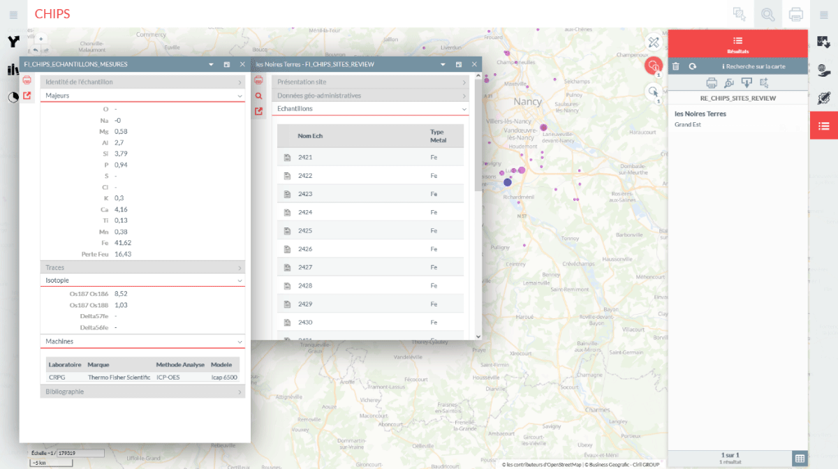
Figure 2
Example of chemical data vizualisation for a sample coming from the ‘Noires Terres’ archaeological context (blue marker highlighted on the cartographic view).
This IT setup has two drawbacks. First, the ready-to-use GEO app is commercial software, requiring regular license renewal; otherwise, the technology can no longer be used. Second, although the FNP/Huma-Num platform provides strong IT security, it also imposes restricted database administration privileges, with only the PostgreSQL port (5432 by default) accessible to the authors. As a result, the database has limited interoperability with other software, such as dashboards, APIs, and external services.
5.2. The CHIPS RESTful API
To overcome these interoperability limitations, and stay in an open-source environment, we established a copy of the CHIPS instance on an Ubuntu virtual machine hosted on the Cloud@VirtualData platform of the Mésocentre Paris-Saclay. This copy operates in a more permissive environment, enabling the integration of additional IT applications, in particular with PostgREST. Regular data-only dumps from CHIPS to CHIPS-dev are performed using a Bash script.
The standalone PostgREST web server allows to expose a selection of CHIPS views as RESTful API endpoints. To demonstrate the value of reusing archaeometallurgical chemical data, we chose to first publish views of previously normalized datasets along with their bibliographic references. While PostgREST provides online access to raw data, we also deployed a Python dashboard that consumes these data to model the different datasets and provide a synoptic view of the CHIPS database content (Figure 3).
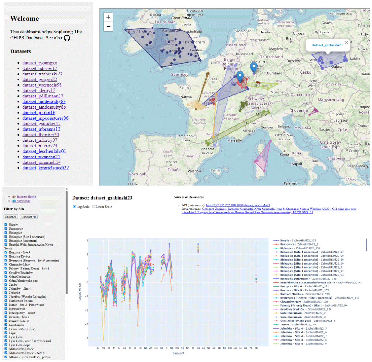
Figure 3
Two views of the CHIPS dashboard (https://iramat-apps.cnrs.fr/dash/). Top: Landing page of the CHIPS dashboard, showing the spatial distribution of CHIPS interoperable (API-based) datasets. Bottom: A selection from the dataset by Grzegorz Żabiński et al. (2023), displayed as a Plotly line chart in log10 scale (https://iramat-apps.cnrs.fr/dash/dataset_gzabinski23). This dashboard page also provides access to the raw data from Grzegorz Żabiński et al. (2023) in JSON format (https://157.136.252.188:3000/dataset_gzabinski23), and allows filtering by site and sample.
Additional information is provided on the CHIPS database website.
While the CHIPS dashboard aims to provide a synoptic view of the database content for dataset selection, we have started to develop an R package (iRamat; Institut de Recherche sur les ArchéoMATériaux n.d.) for more refined and advanced statistical analysis. Currently, this package includes only a limited number of functions (one of which connects to and retrieves data from the CHIPS API) and serves primarily as a prototype (Figure 4) for the future development of an R connector within the ASTR R package (Rose 2026). By doing so, our goal is to foster collaboration among archaeometallurgists—potentially alongside their datasets—in order to build a collective tool useful to the community, helping to standardise and make archaeometallurgical data more reusable.
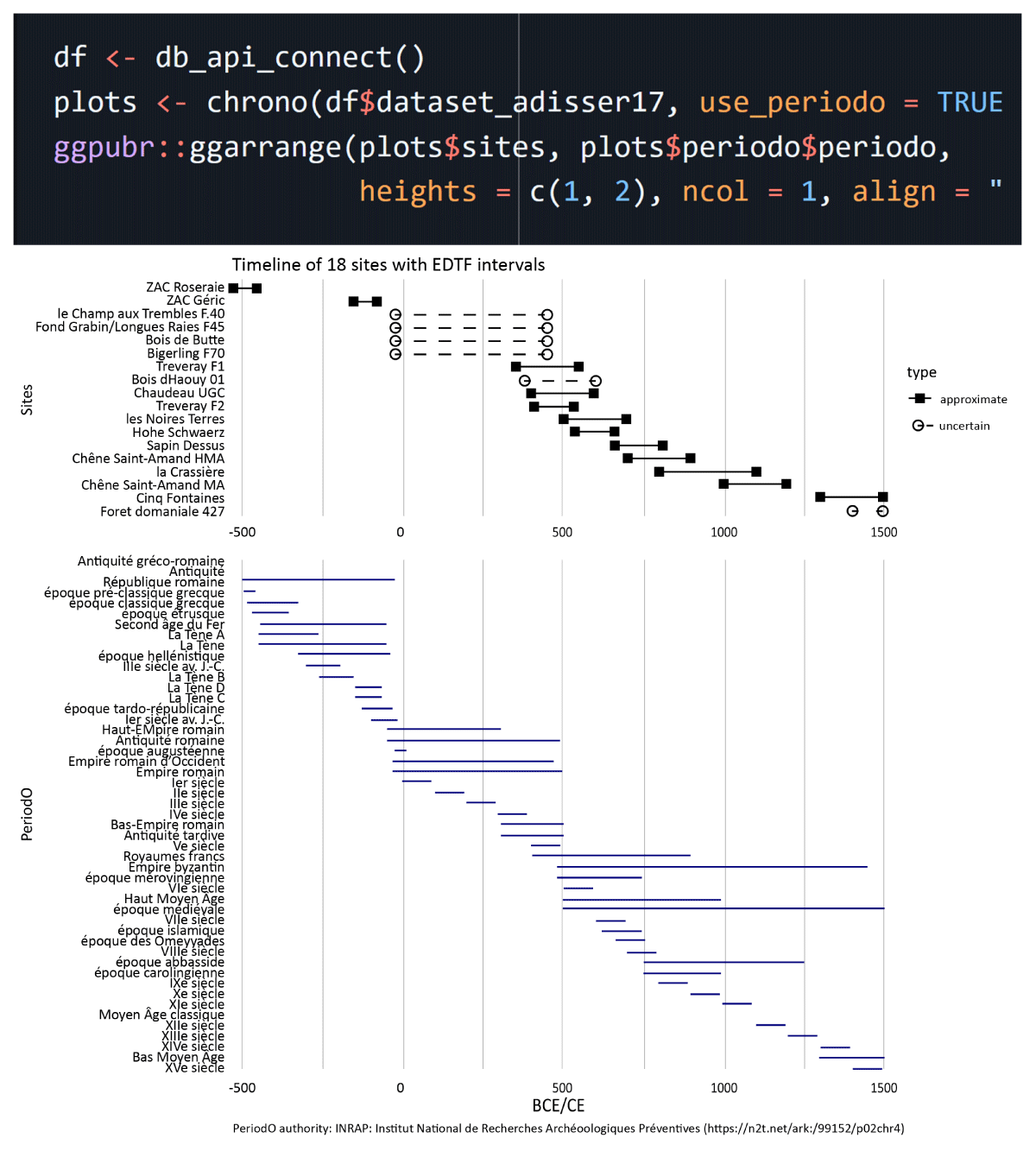
Figure 4
Screenshot of the README.md page of the iRamat R package (https://github.com/iramat/iRamat), showing the output of the chrono() function. At the top, eighteen site time spans (in EDTF) are displayed from the Disser et al. (2017) CHIPS dataset, retrieved via the dataset’s raw data API (https://157.136.252.188:3000/dataset_adisser17). At the bottom, the PeriodO periods are shown from the authority “INRAP: Institut National de Recherches Archéologiques Préventives. PACTOLS chronology periods used in DOLIA data. 2021” (PeriodO – PACTOLS chronology; https://n2t.net/ark:/99152/p02chr4).
6. Perspectives
Core developments
The CHIPS database is now at an advanced stage of development. The conceptual model has been tried and tested, ensuring the smooth operation of already implemented functions. The next stages of development will focus on improving the data query interface, particularly by introducing new query options. The database currently provides open access to 3,000+ chemical analyses related to 580+ archaeological contexts. However, it contains a total of 7,314 analyses from 1,298 different contexts. Moderation work is underway to ensure that the dissemination of these analyses complies with legislation on the protection of intellectual property rights. The repository will soon be enriched by the integration of structural data, such as the results of X-ray diffraction analyses. This data will be expressed in fractions of mineralogical species (e.g., hematite, siderite, quartz, etc.), and will be particularly useful for describing ore samples and enabling further interpretation of the geological contexts in which they were extracted.
User community
We aim to structure a community of users around the database in a bottom-up organization to foster collaborative research. The use of this tool will provide an opportunity to collectively consider the production of archaeometallurgical chemical data from different perspectives: intercomparability, reference materials, and analytical protocols. The rules for contributions, the contributions themselves, the intellectual property of the data, and their reuse rules are explicitly and transparently documented on the dabatase’s website (https://iramat.github.io/chips/docs/#how-to-cite). We envisage a CC-BY 4.0 license for the data, CC0 for the metadata, ODbL for the database and MIT for the computer code.
Expanding the database
An international communication campaign is being conducted via a webinar and a mailing list. A workflow for feeding the database with additional datasets is proposed on the website (https://iramat.github.io/chips/docs/#how-to-contribute). This will lead to the import of several new datasets in the near future, conducted by members of the user community. The data will be moderated prior to their integration into the database.
The initial communication campaigns around the CHIPS database have also sparked interest among researchers who are not strictly focused on iron archaeometallurgy. For example, “ore” is a cultural term used to identify a rock or mineral from which metal can be extracted. The same rock or mineral might instead be used as a pigment or colorant in another technological practice, meaning its function and identification depend on its use and context. More generally, the conceptual data model of the CHIPS database can be adapted to create chemical reference systems for the study of other archaeological materials, such as glass or copper alloys.
AI disclosure statement
Language was improved with the assistance of Vibe (Mistral AI, 2024). SQL and Python code was debugged with the assistance of Vibe (Mistral AI, 2024) and ChatGPT (OpenAI, 2023).
Acknowledgements
The authors would like to thank Marion Berranger, Marc Leroy (Laboratoire Métallurgies et Cultures – IRAMAT UMR 7065) and Gaspard Pagès (Institut Français du Proche-Orient, UMIFRE) for the fruitful discussions having led to the conception of the typological structure. We are also grateful to Christophe de Traversay who provided useful advices on some of the SQL functions we developed. We sincerely thank the PCI Archaeology recommender and the three reviewers for their detailed and constructive feedback, which greatly enhanced our work.
This work was performed using computational resources from the “Mésocentre” computing center of Université Paris-Saclay, CentraleSupélec and École Normale Supérieure Paris-Saclay supported by CNRS and Région Île-de-France (https://mesocentre.universite-paris-saclay.fr/).
Author Contributions
Conceptualisation: A. Disser, T. Huet, S. Bauvais, T. Birch, P. Dillmann; data curation: A. Disser, S. Bauvais; resources: L. Costa, M. Leoni; software: T. Huet; writing: A. Disser, T. Huet; review and editing: A. Disser, T. Huet.
Peer review
This article has been reviewed & recommended by PCI Archaeology (https://doi.org/10.24072/pci.archaeo.100610).