
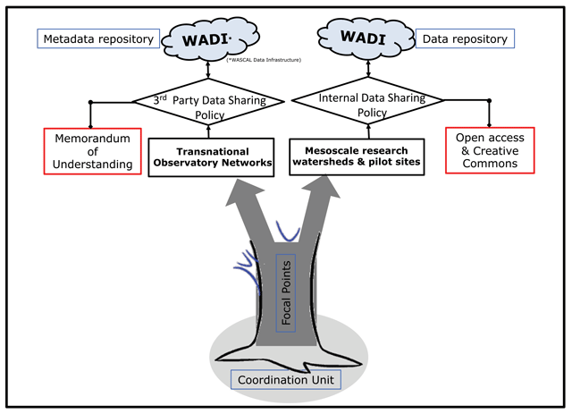
Figure 1
Components and governing principles of the transboundary observation networks (Observations “Boabab tree”) at the West African Science Service Centre on Climate Change and Adapted Land use (www.wascal.org).
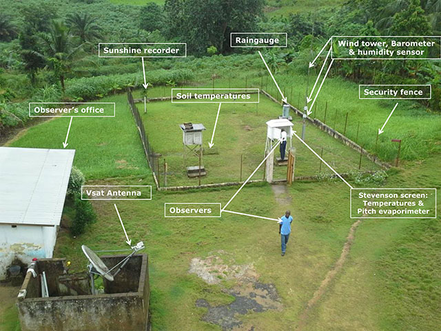
Photo 1
A typical primary synoptic station: A park of sensors in an enclosure near observers’ office, a transmission system with an 8-hour shift of five operational observers.
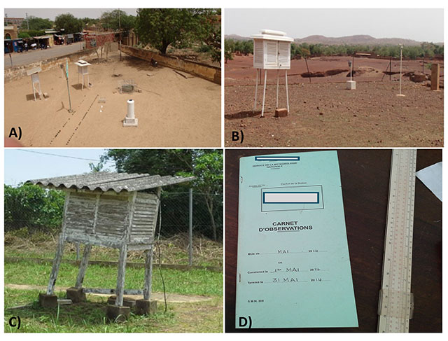
Photo 2
Status-quo of selected primary weather stations in West Africa and its basic components. A) A synoptic station overcome by urbanization in Burkina Faso. B) A climate station with defective and missing sensors in Burkina Faso. C) A tilted Stevenson screen hosting maximum, minimum, dry and wet bulb temperatures, and a pitch evaporimeter in Togo. D) The observer’s logbook for recording data and a manual slide rule still in use to derive some additional variables in most of the observatories.
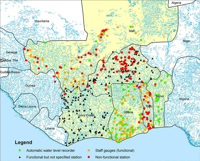
Figure 2
Existing surface water observatories of the six riparian countries of the Volta Basin according to survey questionnaires delivered to the National Hydrological Services. The majority of the functional stream flow stations are equipped with staff gauges where the water level is usually read manually once a day. Although, the metadata of the equipment in Cote d’Ivoire is updated, some countries are better equipped than others. Ghana has more than 50 functional automatic water level recorders; Burkina Faso has reported twenty-four and Mali reported only eight. Togo had none until 2016 when six OTT Radar Level Sensors equipped with automatic transmission systems were installed on the Mono River Basin with the support of external funding.
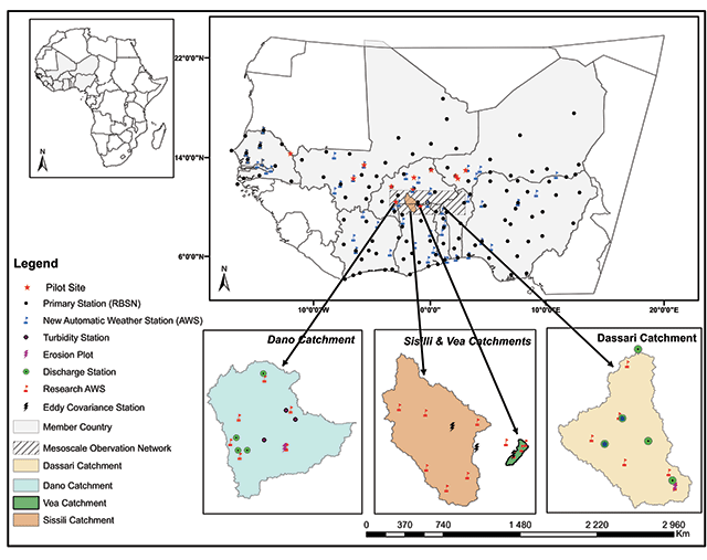
Figure 3
Current distribution of newly installed automatic weather observing systems (AWOS) (blue flag) relative to existing regional basic synoptic network (RBSN) owned by national meteorological services/agencies of countries. In cases of upgrading, the AWOS are installed inside the fenced area of a synoptic station to stay in parallel with manual sensors (black dots are overlaid on blue flags). In addition, the area of the mesoscale research observatories are shown established for the three georeferenced catchments (Dano, Sissili/Vea & Dassari catchments) and further pilot sites (red star) where state-of-the art and cutting-edge hydro-meteorological sensors and field experiments are running and science-based services are being tested and developed.
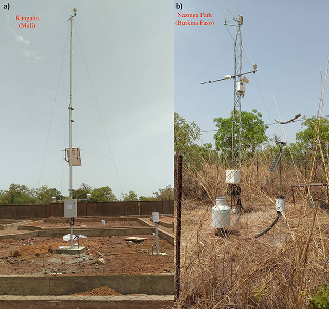
Photo 3
(Left) A typical automatic weather observing system (AWOS) provided to the countries to upgrade, replace or add new locations to the observatory networks of the national meteorological and hydrological services or agencies (NMHS/As) in West Africa (e.g. Installation completed at Kangaba station for the benefit of Mali-Meteo, Mali). (Right) Typical high resolution eddy-covariance station installed in the mesoscale watersheds and pilot sites (e.g. Nazinga Range Land) for research activities.
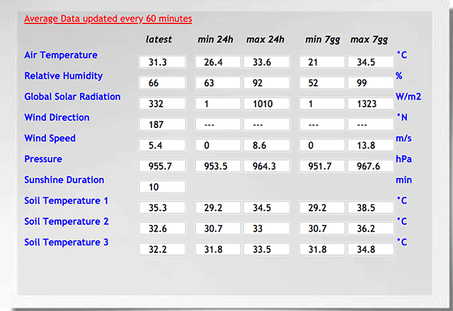
Photo 4
A screenshot of the user-friendly display table of observed data statistics provided by the AWOS for some essential climate variables.
Table 1
Updated metadata of the transnational observatory network sponsored fort the benefit of national meteorological and hydrological services or agencies (NMHS/As) of ten West African countries.
| Country | WASCAL ID | Name | Latitude | Longitude | Type (Previous) | Current Status | First record |
|---|---|---|---|---|---|---|---|
| Benin | 2917020 | Garou | 11.4766 | 3.2856 | Unknown | New | Oct-2018 |
| 2917019 | Materi | 10.4216 | 1.0288 | Unknown | New | Jan-2018 | |
| 2917023 | So-ava | 6.3383 | 2.246 | Unknown | New | Jan-2018 | |
| 2917024 | Grand-Popo | 6.1636 | 1.4754 | Climate | Upgrade | Jan-2018 | |
| Burkina Faso | 2617036 | Boassa, Ouaga | 12.291944 | –1.607222 | Unknown | New | Mar-2018 |
| 2617009 | Gounghin | 12.1449 | –0.0201 | Raingauge | New | Mar-2018 | |
| 2617047 | Kaya | 13.091 | –1.0873 | Climate | Upgrade | Mar-2018 | |
| 2617048 | Leba | 13.2339 | –2.212 | Unknown | New | Mar-2018 | |
| 2617031 | Ouessa | 11.0294 | –2.4693 | Unknown | New | Mar-2018 | |
| 2617032 | Tiankoura | 10.4603 | –3.1549 | Raingauge | Upgrade | Mar-2018 | |
| Cote d’Ivoire | 2517028 | Mbengue | 10.001 | –5.5391 | Raingauge | Upgrade | Mar-2018 |
| 2517027 | Kong | 9.0941 | –4.3691 | Raingauge | Upgrade | Mar-2018 | |
| 2517012 | Seguela | 7.9772 | –6.6738 | Climate | Upgrade | Mar-2018 | |
| 2517011 | Daloa* | 6.9089 | –6.4383 | Synoptic | Upgrade | Mar-2018 | |
| 2517007 | Abengourou | 6.7352 | –3.493 | AgroMet | Upgrade | Mar-2018 | |
| 2517008 | Grand-Bassam | 5.2 | –3.733333 | Climate | Upgrade | Mar-2018 | |
| Ghana | 3317029 | Kpando | 7.036329 | 0.300661 | Climate | Upgrade | Nov-2017 |
| 3317030 | Hunhunya | 6.1015 | –0.1064 | Unknown | New | Nov-2017 | |
| 3317046 | Ejura | 7.382555 | –1.368206 | Climate | Upgrade | Nov-2017 | |
| 3317037 | Manga-Bawku | 11.016165 | –0.26589 | Climate | Upgrade | Nov-2017 | |
| 3317038 | Kpandai | 8.4705 | –0.0116 | Unknown | New | Nov-2017 | |
| 3317045 | Tuna | 9.2965 | –2.2548 | Unknown | New | Nov-2017 | |
| Mali | 2317042 | Bamako* | 12.555278 | –7.973056 | Synoptic | Upgrade | Mar-2018 |
| 2317003 | Kangaba | 11.953333 | –8.431389 | Climate | Upgrade | Mar-2018 | |
| 2317041 | Baroueli | 13.088611 | –6.858056 | Climate | Upgrade | Mar-2018 | |
| 2317035 | Niono | 14.291111 | –5.970278 | AgroMet | Upgrade | Mar-2018 | |
| 2317004 | Yanfolila | 14.952778 | –8.614722 | Climate | Upgrade | Mar-2018 | |
| Niger | 2717014 | Chical | 14.1509 | 3.2649 | Climate | Upgrade | Apr-2018 |
| 2717040 | Matankari | 13.4626 | 4.003å | Climate | Upgrade | Apr-2018 | |
| 2717039 | Goudoumaria | 13.4209 | 11.1178 | Climate | Upgrade | Apr-2018 | |
| 2717010 | Dogon Kiria | 14.058 | 4.3658 | Climate | Upgrade | Apr-2018 | |
| 2717013 | Sekoukou | 13.2717 | 2.36556 | Unknown | New | Apr-2018 | |
| Nigeria | 3417006 | Zaria* | 11.13603 | 7.68945 | Synoptic | Upgrade | Jul-2018 |
| 3417022 | Dutse* | 11.89166 | 9.3166 | Synoptic | Upgrade | Jul-2018 | |
| 3417021 | Yelwa* | 11.0386 | 4.5 | Synoptic | Upgrade | Jul-2018 | |
| 3417005 | Akure | 7.24754 | 5.29976 | Synoptic | Upgrade | Jul-2018 | |
| 3417002 | Osogbo* | 7.77085 | 4.4811 | Synoptic | Upgrade | Jul-2018 | |
| 3417001 | Oshodi*, Lagos | 6.5454 | 3.34702 | Synoptic | Upgrade | Aug-2018 | |
| Senegal | 2117043 | Diourbel* | 14.6691667 | –16.243054 | Synoptic | Upgrade | Mar-2019 |
| 2117026 | Linguere* | 15.4030556 | –15.0925 | Synoptic | Upgrade | Mar-2019 | |
| 2117044 | Podor* | 16.6563889 | –14.95861 | Synoptic | Upgrade | Mar-2019 | |
| 2117025 | Kaolack* | 14.150 | –16.058055 | Synoptic | Upgrade | Mar-2019 | |
| 2117047 | Koungheul | 13.970 | –14.830 | Climate | Upgrade | Mar-2019 | |
| The Gambia | 2017017 | Njau | 13.754166 | –15.221388 | Unknown | New | Dec-2018 |
| 2017018 | Bakadagi | 13.312778 | –14.401111 | Unknown | New | Dec-2018 | |
| 2017050 | Sutukoba | 13.5001 | –14.0145 | Unknown | New | Dec-2018 | |
| Togo | 2817033 | Kpalime | 6.8823 | 0.6467 | Synoptic | Upgrade | Dec-2017 |
| 2817034 | Lome* | 6.1049 | 1.152 | Synoptic | Upgrade | Dec-2017 | |
| 2817016 | Sotouboua | 6.410 | 1.20 | Raingauge | Upgrade | Dec-2017 | |
| 2817015 | Bafilo | 9.363 | 1.25 | Raingauge | Upgrade | Dec-2017 |
[i] * Station belonging to the regional basic synoptic and/or climatic observation networks of the WMO/global observing system (GCOS).
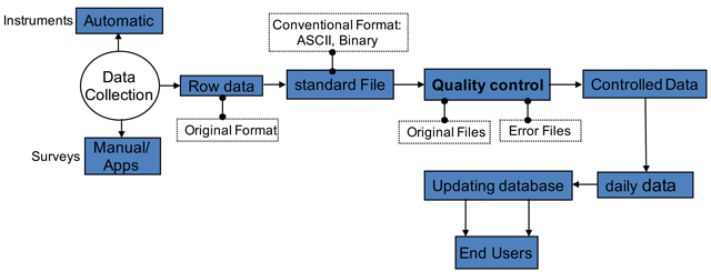
Figure 4
Conceptual work flow on data processing for quality control applied to the transboundary observatory networks datasets.