
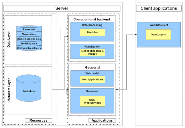
Figure 1
Platform ‘Climate’ general architecture outline.
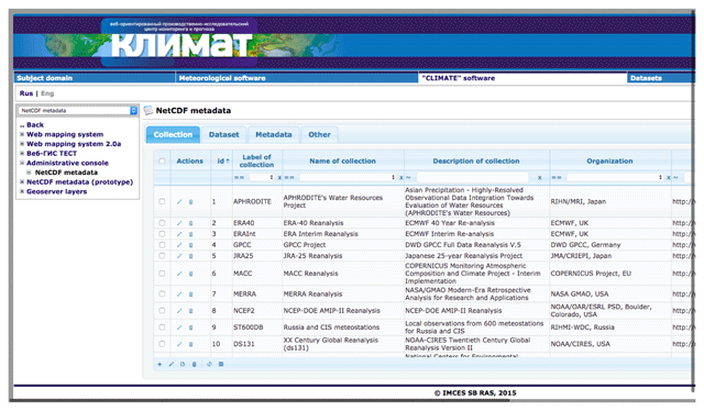
Figure 2
Administrative web console GUI.
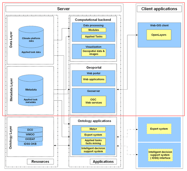
Figure 3
Platform ‘Climate+’ general architecture outline.
Table 1
Classes of applied ontologies.
| Class | Class | SubClassOf |
|---|---|---|
| iao:Collection (C) | iao:Data_array (DA) | iao:Physical_data |
| iao:Organization (O) | iao:Longitudes_list (Lol) | iao:Physical_data |
| iao:Data_set (DS) | iao:Latitudes_list (Lal) | iao:Physical_data |
| iao:Scenario (S) | iao:Height_levels_list (HLl) | iao:Physical_data |
| iao:Spatial_resolution (SR) | iao:Times_list (Tl) | iao:Physical_data |
| iao:Time_step (Ts) | iao:Spatiotemporal_system (SS) | |
| iao:Physical_quantity (PQ) | iao:Unit (U) | |
| iao:Physical_data (PD) | ||
| wmo:Products | wmo:Land_surface_products | wmo:Products |
| wmo:Soil_category | wmo:Land_surface_products | |
| wmo:Meteorological_products | wmo:Products | |
| wmo:Temperature_category | wmo:Meteorological_products | |
| tsu:Task | tsu:InputData | tsu:Data |
| tsu:Data | tsu:OutputData | tsu:Data |
| tsu:MeteorologicalParameter | tsu:SubjectParameter | |
| tsu: CriticalTimeInterval | tsu:SpatioTemporalObject | tsu:RiverStretch |
Table 2
Object properties of the ontology of climate information resources.
| Domain | ObjectProperty | Range | |
|---|---|---|---|
| iao:Collection | iao:has_organization (do) | iao:Organization | o01 |
| iao:Collection | iao:has_data_set | iao:Data_set | o02 |
| iao:Data_set | iao:has_scenario | iao:Scenario | o03 |
| iao:Data_set | iao:has_spatial_resolution | iao:Spatial_resolution | o04 |
| iao:Data_set | iao:has_time_step | iao:Time_step | o05 |
| iao:Data_set | iao:has_data_array | iao:Data_array | o06 |
| iao:Physical_data | iao:has_physical_quantity (dpq) | iao:Physical_quantity | o07 |
| iao:Physical_data | iao:has_unit | iao:Unit | o08 |
| iao:Data_array | iao:has_spatiotemporal_system | iao:Spatiotemporal_system | o09 |
| iao:Spatiotemporal_system | iao:has_longitudes_list | iao:Longitudes_list | o10 |
| iao:Spatiotemporal_system | iao:has_latitudes_list | iao:Latitudes_list | o11 |
| iao:Spatiotemporal_system | iao:has_height_levels_list | iao:Height_levels_list | o12 |
| iao:Spatiotemporal_system | iao:hat_times_list | iao:Times_list | o13 |
| tsu:Task | tsu:hasInputData | tsu:InputData | o14 |
| tsu:Task | tsu:hasOutputData | tsu:OutputData | o15 |
| tsu:SpatioTemporalObject | tsu:hasMeteorologicalParameter | tsu:MeteorologicalParameter | o16 |
| tsu:SpatioTemporalObject | tsu:hasSubjectParameter | tsu:SubjectParameter | o17 |
| tsu:Data | tsu:hasSpatioTemporalObject | tsu:SpatioTemporalObject | o18 |
| tsu:RiverStretch | tsu:hasCriticalTimeInterval-Shipping | tsu: CriticalTimeInterval | o19 |
| tsu:RiverStretch | tsu:has CriticalTimeInterval-Crossing | tsu: CriticalTimeInterval | o20 |
Table 3
Datatype property of the ontology of climate information resources.
| Domain | DatatypeProperty | Range | |
|---|---|---|---|
| iao:Physical_data | iao:has_number_of_values (dn) | int | d01 |
| iao:Physical_data | iao:has_minimum_value (dmiv) | float | d02 |
| iao:Physical_data | iao:has_maximum_value (dmav) | float | d03 |
| iao:Physical_data | iao:has_value (dv) | float | d04 |
| iao:Physical_data | iao:has_step_value | str | d05 |
| iao:Times_list | iao:has_initial_time (dit) | str | d06 |
| iao:Times_list | iao:has_final_time (dft) | str | d07 |
| tsu:Task | tsu:hasMathematicalStatement | anyURI | d08 |
| tsu:Task | tsu:hasPhysicalStatement | anyURI | d09 |
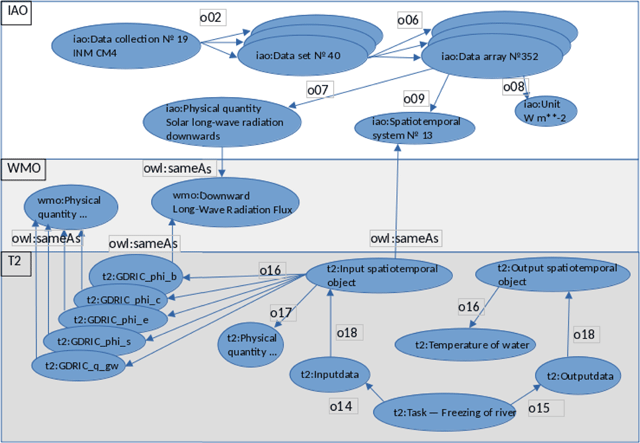
Figure 4
Simplified representation of individuals, describing PLASIM and INM CM4 data collections, taxonomy of WMO physical quantities, and individuals of T1 (soil freezing and thawing) and T2 (freeze-up on a river) applied tasks.
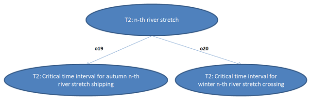
Figure 5
An example of an individual characterizing a river stretch used when deciding on the end of navigation in various stretches of the Ob River and the time of the opening of the stretch for transport crossings on ice.