
Table 1
Structure of the extended IGSN for ICDP sample material. The coded pattern is directly derived from the internal object-ID in the DIS, and therefore guarantees uniqueness of the sample.
| Name Space | Expedition ID | Report Prefix | Object Tag | Coded Pattern |
|---|---|---|---|---|
| ICDP | 5054 | E = Expedition R = Repository | H = hole C = core run S = core section X = sample | W1001 |
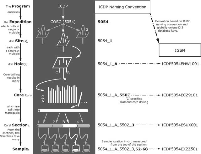
Figure 1
Mapping of sample objects to IGSNs. Example of the data structure and IGSN assignment for drill holes, core runs, core sections and core samples by the ICDP DIS as assigned during the COSC-1 project. The Expedition ID (here ‘5054’ for COSC) is defined as unique key value in the ICDP naming convention and is accompanied by a character string that includes indicators for drill Site and Hole (several boreholes per site and several sites per expedition can exist). Each lower level of the sample hierarchy (Core runs, Sections and Samples) are symbolized by additional characters or numbers to the name of the higher level. The Hole is the top level for the IGSN. Each derived object (core runs, core sections, samples, etc.) is related to the borehole through the parent-child relation of each subordinated object/sample.
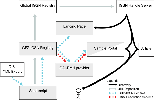
Figure 2
Visualisation of the registration infrastructure. The associcated XML metadata flows (dotted lines and arrows) at the GFZ IGSN Allocating Agent during registration of ICDP samples are shown. Building blocks of the IGSN allocating agent are highlighted in grey boxes. In additon, the steps of an exemplary sample discovery through a web portal or a research article are shown as black arrows.
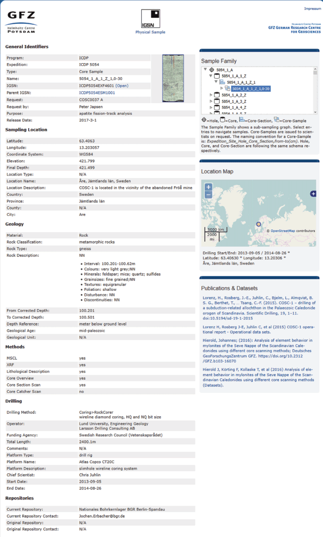
Figure 3
Example of an IGSN Landing Page for a Core Sample of the COSC-1 project (IGSN:ICDP5054EXF4601). The left part contains the full sample description thematically grouped into General Identifiers (for the drilling project and the IGSN hierarchy), Sampling Location, Geology, and Methods used to produce primary borehole data, Drilling (details on the drilling method, instrumentation, PIs, and drilling dates) as well as location of the sample (Repositories). The top right box allows to browse through the sample hierarchy. Different icons indicate the type of sample (Hole, Core, Core Section, Core Sample). The map below shows the geographical location, whereas the lower right part highlights publications that are related with the sample (here the initial scientific publication in Scientific Drilling Journal8 and the Operational Report of COSC-1, Lorenz et al. 2015a and 2015b, and the master thesis and the data publication of Hierold 2016 and Hierold et al. 2016).