
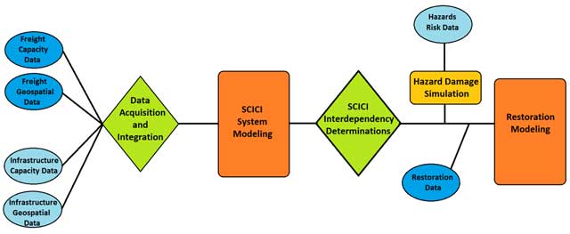
Figure 1
Schematic work flow pattern for transportation infrastructure system restoration modeling.
Table 1
Data Requirements for Transportation Sector (modified from Long et al., 2013).
| Category | Data Description | Data Metric | Ownership | Data Challenges |
|---|---|---|---|---|
| Freight Data | ||||
| Commodity Freight | Food, Paper, Wine, etc. | Tons | Public | Static data; Generalized data; Proprietary data |
| Manufactured Goods | Electronics, Machinery, Textiles, etc. | Tons | Private/Public | |
| Raw Materials | Coal, Iron Ore, Bauxite, etc. | Tons | Private/Public | |
| Freight Flow Data | ||||
| Road Transport | Goods transported over roads | Tons | Private/Public | Inconsistency Estimation required Public/Private ownership |
| Rail Transport | Goods transported on rail | Tons | Private | |
| Air Transport | Goods transported by air | Tons | Private | |
| Water Transport | Goods transported by water | Tons | Private/Public | |
| Pipeline Transport | Goods transported through pipeline | Tons | Private/Public | |
| Infrastructure Capacity Data | ||||
| Road-Hub | Bulk, General Cargo, Containers, etc. | Tons | Private | Varied amount of data needed Different capabilities of hubs Interdependency of data |
| Rail-Hub | Bulk, Intermodal, Shunting, etc. | Tons | Private | |
| Water-Hub | Rail Car Storage, Dry Storage, Liquid Storage | Tons/Bushels | Private | |
| Infrastructure Location Data (Geospatial Data) | ||||
| Hub Location | Number of hubs in the area | Number | Private | Ever changing data; Use of Software; Static data |
| Utility Location | Location of all utilities that aid freight flow | Number | Private/Public | |
| Road/Bridge Location | Location of all roads and bridges | Number | Public | |
| Airport Location | Location of air infrastructure | Number | Private | |
| Pipeline Location | Location of pipelines and pumping stations | Number | Private | |
| River Location | Location of docks and storage areas | Number | Private | |
| Rail Location | Location of all rail infrastructure | Number | Private | |
| Restoration Data | ||||
| Number of People | Number of people need and available | Number | Private/Public | Different temporal factors Vast amount of data Scalability Ownership of data |
| Travel Time | Time required for teams to arrive in area | Hours/Days | Private/Public | |
| Skill Set | Skills necessary for each repair job | Qualitative | Private/Public | |
| Mode Substitution | Mode substitutions facilitating freight flow | Mode | Private/Public | |
| Task Management | Assignment and management of repair tasks | Qualitative | Private/Public | |
| Equipment Necessary | Materials require for restoration | Tons/Pieces | Private/Public | |
| Hazard Risk and Vulnerability Data | ||||
| Historic Data | Previous hazards that have caused damage | Text | Private/Public | Inconsistency Generalized data Proprietary data |
| Fragility Data | Vulnerability of element to hazard | Percentage | Public | |
| Damage Estimation | Severity and extent of damage from simulation | Percentage | Public | |
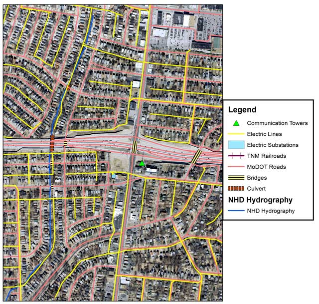
Figure 2
Orthoimagery, hydrography (National Hydrography Dataset, NHD) and rail data for St. Louis, Missouri region from The National Map of the U.S. Geological Survey. Road data are from the Missouri Department of Transportation. Data from the U.S. Geological Survey and the Missouri Department of Transportation are in the public domain and freely available for download. Other elements (communications, electric power) are derived from the public domain orthoimagery.
Table 2
Data acquired and integrated for SCICI modeling for St. Louis metro area.
| Title | Description | Source | Restrictions | Data Processing |
|---|---|---|---|---|
| Geospatial Data | Several layers of TNM data serve as the base to all data integration processes: orthoimagery, elevation, hydrograph, place-names and land use | The National Map of the U.S. Geological Survey | Open access/public data | None |
| Infrastructure Data | Infrastructure data such as airports, electric grid, bridges, overpasses, tunnels, culverts, dams, docks, pumping stations… | Extrapolate from The National Map | Open access/public data | Digitization |
| Transportation Data | Road and rail lines | State departments of transportation | Varies from state to state | Re-projection to desired coordinates |
| Communication Data | Cell Towers | Federal Communications Commission | Open access/public data | Re-projection to desired coordinates |
| Supply Chain Data | Rates of flow of commodities | U.S. Department of Commerce and Private Industry sources | Public/Private | Integration with geospatial data |
| Restoration Data | Rate and manner in which supply chain elements are repaired after a large-scale disaster | Federal, State and Local Governments | Open access/public data | Integration with geospatial data |
| Hazard Data | The nature of destruction of specific supply chain elements by any large-scale disaster | Federal, State and Local Governments | Open access/public data | Integration with geospatial data |
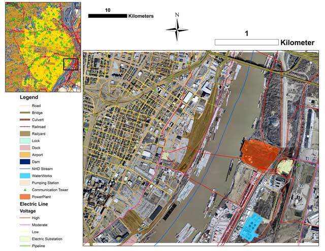
Figure 3
SCICI elements for a section of southern St. Louis, Missouri. Upper left map shows infrastructure in the St. Louis metropolitan area, inset black box shows the expanded area in the larger low right box.
Table 3
For illustrative purposes, a small sample of the infrastructure database is displayed, specifically a few elements of the telecommunications tower infrastructure are displayed. ‘FID’ and ‘OID’ refer to internal indices, while ‘Air Photo Verified’ refers to whether a tower is visible on orthoimagery.
| FID | OID | Latitude | Longitude | Height (Feet) | Structure | Licensee | Street Address | City | State | Type | Air Photo Verified |
|---|---|---|---|---|---|---|---|---|---|---|---|
| 0 | 1 | 38.626525 | −90.283483 | 38.7 | Mast | Global Tower LLC | 1242 Pierce Ave | St Louis | MO | Cell | Yes |
| 1 | 2 | 38.620784 | −90.292921 | 45.7 | Pole | St Charles Tower Inc | 6351 Knox Industrial Drive | St Louis | MO | Cell | Yes |
| 2 | 3 | 38.620330 | −90.289789 | 31.3 | Free Standing or Guyed | Crown Castle Gt Co LLC | 6134 Amanda | St Louis | MO | Cell | Yes |
| 3 | 4 | 38.618919 | −90.295976 | 45.7 | Free Standing or Guyed | Bmb Tower Holdings LLC | 6351 Knox Industrial Drive | St Louis | MO | Cell | Yes |
| 4 | 5 | 38.656295 | −90.298051 | 32.0 | Free Standing or Guyed | Crown Castle Gt Co LLC | 6100 Enright Ave | St Louis | MO | Cell | Yes |
| 5 | 6 | 38.595250 | −90.361663 | 42.6 | Free Standing or Guyed | SBA Towers II LLC | 209 Sherman Place | St Louis | MO | Cell | Yes |
| 6 | 7 | 38.579250 | −90.355333 | 29.0 | Free Standing or Guyed | United States Cellular Corp | 630 S. Elm | St Louis | MO | Cell | Yes |
| 7 | 8 | 38.564824 | −90.356590 | 35.6 | Free Standing or Guyed | Global Tower LLC | 8534 Watson Road | St Louis | MO | Cell | Yes |
| 8 | 9 | 38.548934 | −90.343860 | 47.2 | Free Standing or Guyed | United States Cellular Corp | 10203 Gravois Road | St Louis | MO | Cell | Yes |
| 10 | 11 | 38.529837 | −90.281194 | 365.3 | Free Standing or Guyed | KMOV-TV Inc | 1900 Ave H | Lenay Township | MO | Radio/TV | Yes |
| ⋮ | ⋮ | ⋮ | ⋮ | ⋮ | ⋮ | ⋮ | ⋮ | ⋮ | ⋮ | ⋮ | ⋮ |