

Figure 1
Scientific research process.
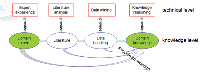
Figure 2
Two level knowledge model employed in our study.
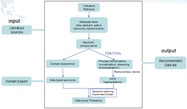
Figure 3
Technical framework of the literature-based disaster data discovery process.
Table 1
Technical steps in the research model.
| Steps | Earthquake as an example |
|---|---|
| Identify scientific question | Multidisciplinary data for certain disaster events |
| Specify the certain disaster events | Take three earthquake events as examples. |
| Obtain the literature data sources | Determine the SCI articles as data sources and search keywords. Separate the obtained literature into two parts: high-cited set and whole set. |
| Segment words of articles | Thomson Data Analyzer is employed to segment the words and phrases. |
| Generalize thesaurus lists | Incorporate expert knowledge to define data type thesaurus from the segmentation words and phrases. |
| Cluster words and classification | Thesaurus list is classified into several groups by semantic mapping and domain knowledge. |
| Calculate frequency value | Thesaurus occurrence frequency is counted by statistical approach. |
| Analyze the statistic results | Multidisciplinary data list for earthquake events is sorted in sequence according to the frequency table. |
| Compare two views of disaster events | The differences of multidisciplinary data on three earthquake events are analyzed in global and local views, possible reasons are presented. |
| Compare two views of multidisciplinary data | The differences of multidisciplinary data on certain earthquake events are analyzed in global and local views, possible reasons are also presented. |
| Conclude | Conclude the analysis result and give some suggestions. |
Table 2
Part of the data type thesaurus.
| Data Types | Thesaurus |
|---|---|
| Geological data | geology, geotechnical, geological investigations, earthquake engineering, topography, topographic, geological, lithology, stratigraphic mapping, fault, thrust belt, slip zones… |
| Geophysical data | geophysical, geoelectric, geodynamic, isostasy, kinematic, gravitational, magnetosphere, magnetotellurics, oscillations, wave, electromagnetic, geochemical, ground-motion… |
| Ground observational data | atmosphere, in situ, field investigation, geodetic, geomorphologic, geodesy… |

Figure 4
Relationship between high-cited set and whole set.

Figure 5
Frequency statistics of multidisciplinary data used in Tangshan earthquake research (WS view and HCS view).
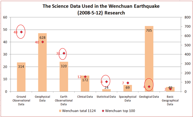
Figure 6
Frequency statistics of multidisciplinary data used in Wenchuan earthquake research (WS view and HCS view).
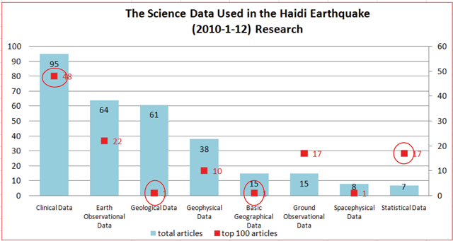
Figure 7
Frequency statistics of multidisciplinary data used in Haidi earthquake research (WS view and HCS view).
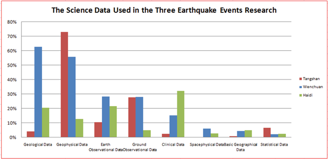
Figure 8
Comparison of multidisciplinary data used in the three earthquake events (WS view).
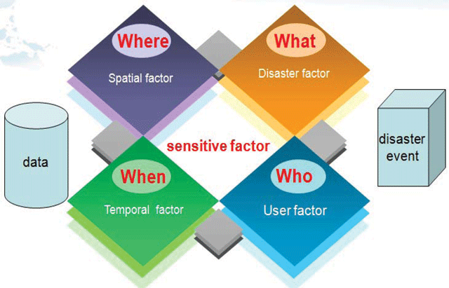
Figure 9
Elements affecting multidisciplinary data for certain disaster events.