
Introduction
The Carpathians are an important centre of vascular plant species diversity. Many relict and endemic species occur there (Kliment et al. 2016; Mráz & Ronikier, 2016). The latter include, among others, the predominantly East-Carpathian taxon Valeriana dacica, whose taxonomic status was recently clarified (Krahulec et al., 2023). A morphological description, photos and herbarium specimens (lectotype and syntype) of Valeriana dacica and the features distinguishing it from Valeriana tripteris can be found in Krahulec et al. (2023) and Kobiv & Dmytrakh (2025).
Valeriana dacica Porcius is a species with the main part of its known distribution in the Eastern Carpathians. Its distribution is insufficiently known, because it has been until recently treated in different ways in various countries. It has been described from Romania several times. For the whole synonymy see Krahulec et al. (2023).
It was hidden under three different names in the Flora of Romania (Morariu, 1961): Valeriana montana var. vernata Schur. (sic, should be ternata), V. tripteris var. heterophylla Baumg. (with synonyms V. bijuga Simk. and V. dacica Porc.), and V. ×ambigua (Gren. et Godr.) Jáv. (V. montana × V. tripteris). Ciocârlan (2009) considered it as a hybrid V. ×ambigua. The name V. transsilvanica Schur. has been used irregularly in Ukraine (Katina, 1961; Prokhudin, 1987; Mosyakin & Fedoronchuk, 1999 Tsymbalyuk, 2022). Other authors considered it as a synonym of V. tripteris (e.g. Čopik, 1976; Čopik & Fedorončuk, 2015) or did not mention it at all (Tasenkevich, 1998). It has been neglected in papers dealing with endemics of the Carpathians (Mráz & Ronikier, 2016). Kliment et al. (2016) gave it as V. tripteris subsp. heterophylla with synonyms V. transsilvanica and V. sisymbriifolia. In this respect, he also mentioned Hadač's (see below) data on V. montana. Recently, the distribution of Valeriana dacica in Ukraine and its differential characters and ecology have been published (Kobiv & Dmytrakh, 2025). This species has a scattered distribution in the whole of the Ukrainian Carpathians; many localities are in the highest SE part of the range.
In Poland, it was named V. transsilvanica Schur (Szafer et al. 1924). Later, Rostański (1967, 1970) had it in two taxa: V. tripteris subsp. heterophylla (Baumg.) Rostański and V. tripteris subsp. austriaca for. bijuga (Simk.) Rostański. Rostański (1970) published also a distribution map for Poland. Later, Oklejewicz (2004) published a list of localities and distribution maps of species of the Valeriana tripteris complex, i.e. subsp. austriaca and subsp. heterophylla, and their intermediate forms in the Beskid Niski Mountains. In Czechoslovakia and later in Slovakia, it has not been distinguished as a separate taxon. The exceptions are floristic and vegetation papers by Hadač and his colleagues (Hadač & Soldán, 1989; Hadač & Terray, 1989, 1991) who distinguished it as V. montana L. This has been influenced by J. Hadinec, who already knew that it is a tetraploid (counted by A. Krahulcová on the living plants collected by J. Hadinec). Figures 1–4 give photos of this not well-known species showing its variation. Special attention should be paid for summer plants, which have different leaf shape on sterile stolons compared with spring ones (cf. Figures 3 and 4).
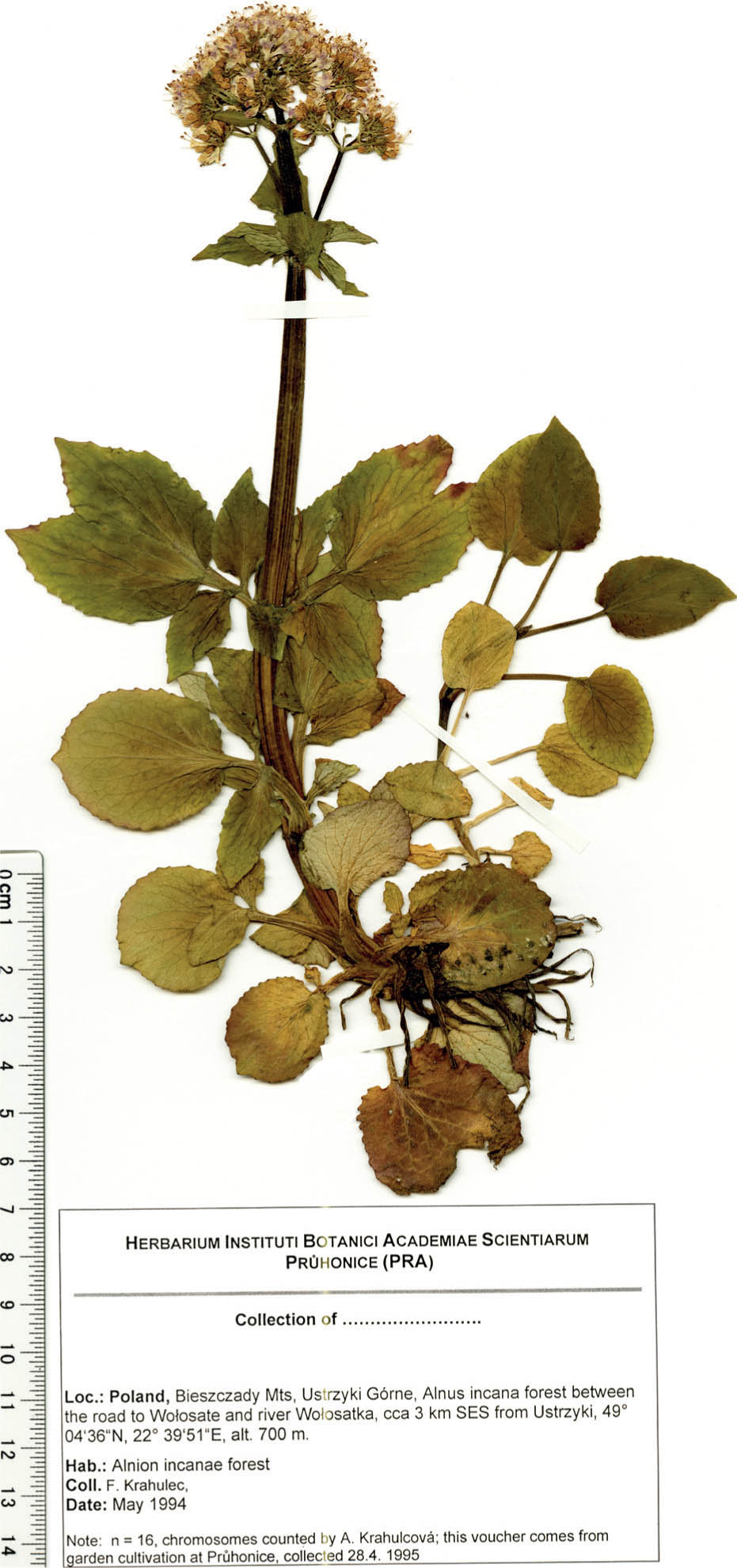
Figure 1:
Valeriana dacica from the Bieszczady Mts. (Poland) with known chromosome number (2n = 32), herbarium PRA.
Slika 1: Valeriana dacica z gorovja Bieszczady (Poljska) z znanim številom kromosomov (2n = 32), herbarij PRA.
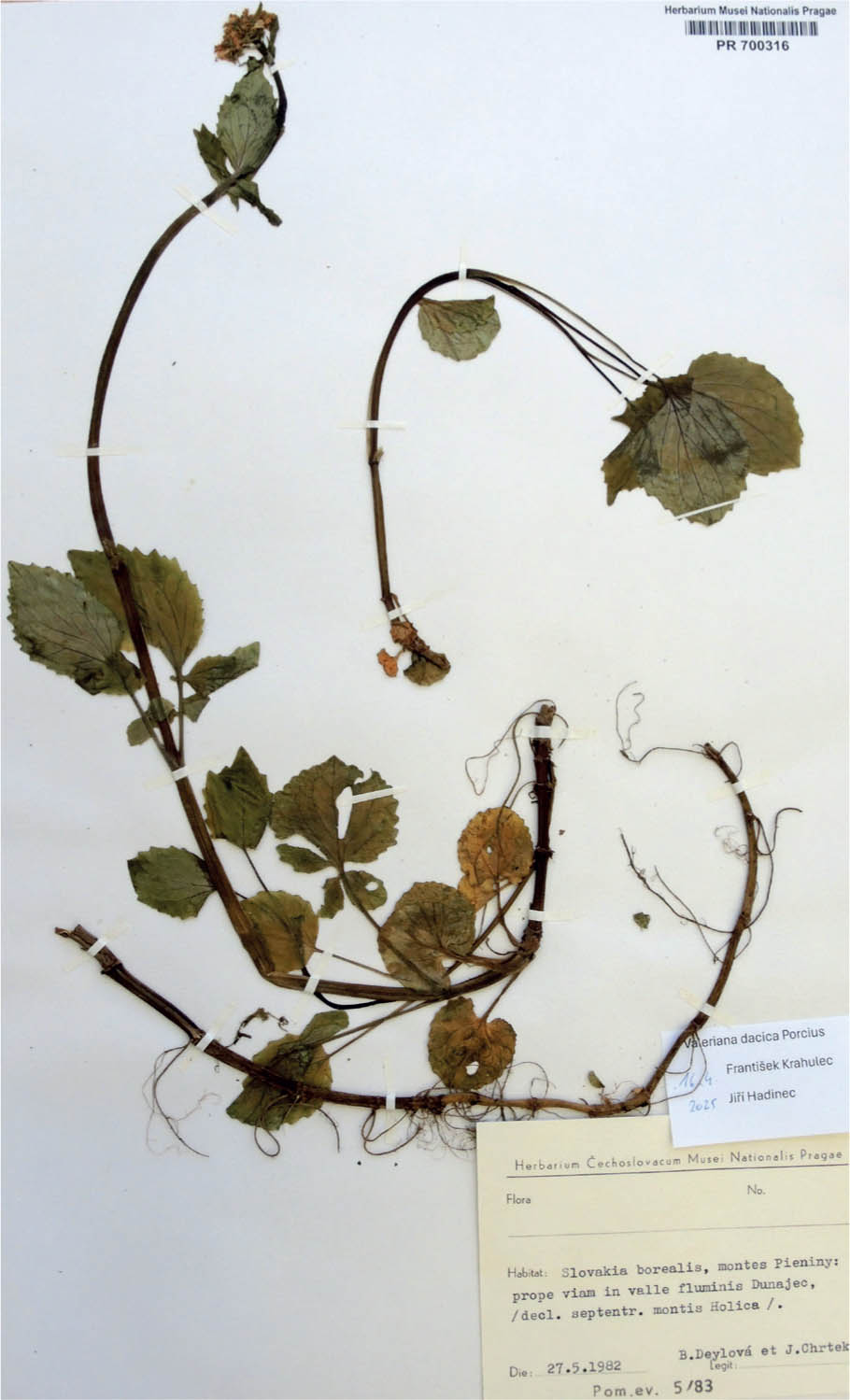
Figure 2:
Valeriana dacica from westernmost locality in the Pieniny Mts. (Slovakia), herbarium PR.
Slika 2: Valeriana dacica z najbolj zahodne lokacije v gorovju Pieniny (Slovaška), herbarij PR.
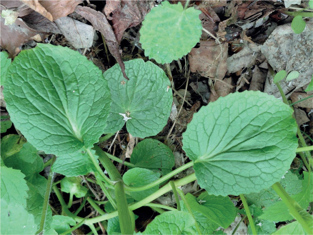
Figure 3:
Spring leaves on the stem base of Valeriana dacica (Wola Piotrowa, Beskid Niski Mts., Poland, loc. 66). Photo P. Kwiatkowski.
Slika 3: Spomladanski listi na spodnjem delu stebla vrste Valeriana dacica (Wola Piotrowa, gorovje Beskid Niski, Poljska, loc. 66). Foto P. Kwiatkowski.
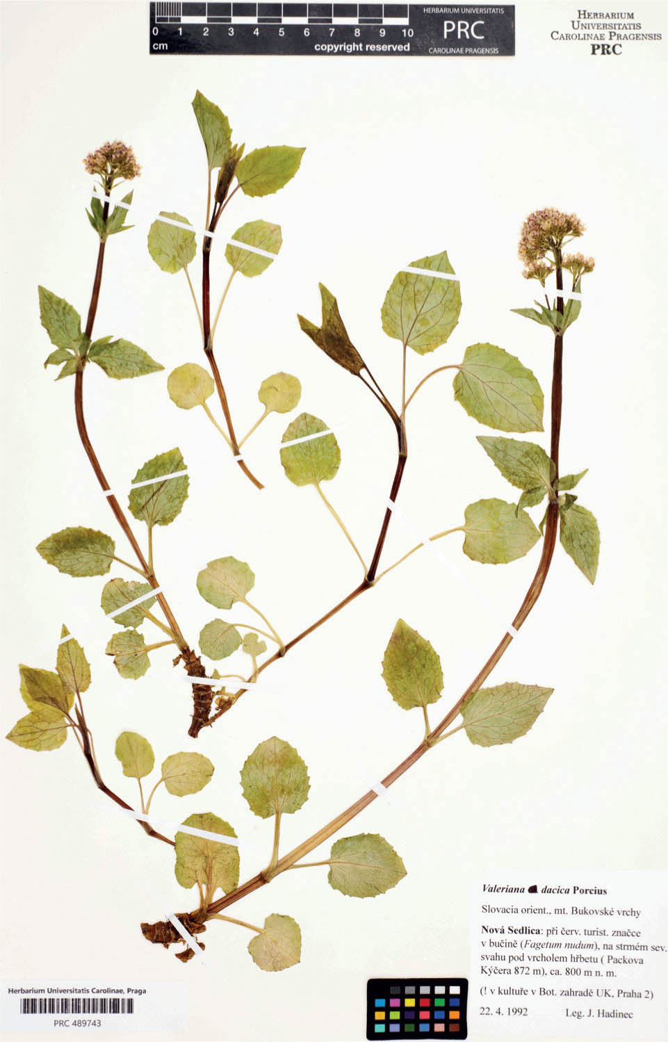
Figure 4:
Valeriana dacica, the Bukovské vrchy Mts (Slovakia), herbarium PRC. Notice that summer leaves on sterile stolons differ from leaves of spring plants.
Slika 4: Valeriana dacica, gorovje Bukovské vrchy (Slovaška), herbarij PRC. Poletni listi na sterilnih stolonih se razlikujejo od listov spomladanskih rastlin.
Because of the differences in its concept between Poland and Slovakia, the distribution of this species on its western area boundary is insufficiently known. For that reason, we decided to study it using herbarium specimens stored in herbaria in Poland, Slovakia and Czechia.
Material and methods
In the years 2023–2026, a revision of herbarium specimens in public herbaria of Central Europe was carried out (BRA, KRA, KRAM, KTU, PR, PRC, SLO). Herbarium acronyms are according to Thiers (2022). The list of localities of Valeriana dacica collected from herbarium specimens includes in the following order: the geographical name (town or village, hill, larger forest complex etc.), a short description of the habitat and phytocoenosis, the date of collection, the name of the collector and the herbarium acronym.
Direct observations of one of us (Jiří Hadinec) were an important source; he worked together with Emil Hadač and because he already distinguished this species as an independent entity he recorded all observed localities directly in the field. For that reason, many of his localities are not based on herbarium specimens. For Slovakia, we used also published data by Hadač & Terray (1991) because they distinguished V. dacica (and named it V. montana) as well as two other papers coauthored by Hadač (Hadač & Soldán, 1989; Hadač & Terray, 1989, 1991). Floristic data from the literature were also considered for Poland. These are studies by Rostański (1970), Święs (1982), Oklejewicz (2004), Wolanin (2014), and Kozłowska-Kozak (2017), in which the authors clearly distinguish the taxon Valeriana tripteris subsp. heterophylla (which is a synonym of Valeriana dacica).
The Valeriana dacica localities are given on the map (Figure 5), and their full description is provided at the end of the article (Appendix 1). All sites were arranged according to mountain ranges stretching from north to south (Poland/Slovakia) and from west to east.
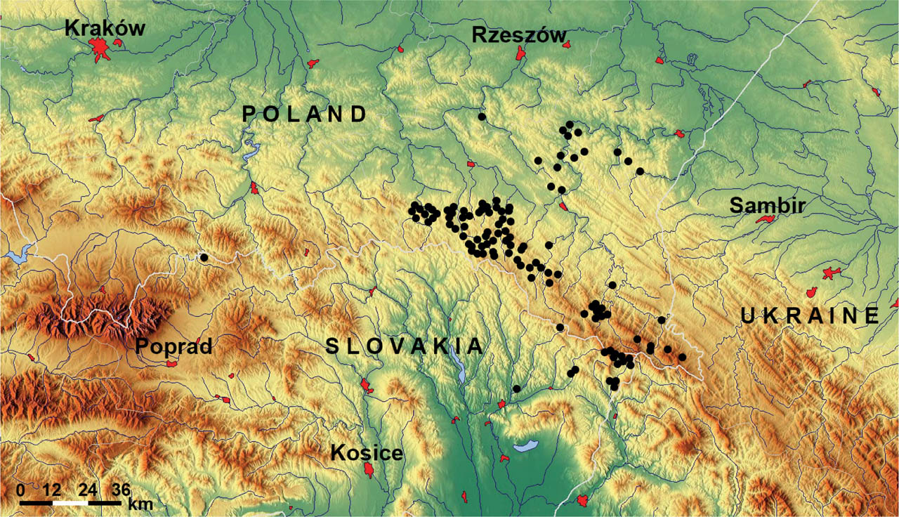
Figure 5:
Distribution of Valeriana dacica localities («•») in Poland and Slovakia (based on the background of the relief map obtained from the website www.maps-for-free.com)
Slika 5: Razširjenost vrste Valeriana dacica («•») na Poljskem in Slovaškem (podlaga za relief je z internetne strani www.maps-for-free.com).
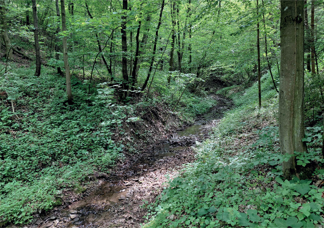
Figure 6:
One of the typical localities of Valeriana dacica on the shores of a small brook in Wola Piotrowa, Beskid Niski mountains, Poland (locality No. 66). Photo P. Kwiatkowski.
Slika 6: Značilna lokacija vrste Valeriana dacica ob malem potoku v Wola Piotrowa, gorovje Beskid Niski, Poljska (lokacija št. 66). Foto P. Kwiatkowski.
The issue of the phytogeographic boundary between the Western Carpathians and the Eastern Carpathians was adopted according to the studies by Zemanek (1991a, b).
Results and discussion
In total, we reviewed 131 herbarium specimens (excluding duplicates) that were identified as Valeriana dacica (see Appendix 1). This taxon has been recorded in Poland and Slovakia in several phytogeographical districts of the Western Carpathians (Pieniny, Pogórze Dynowskie, Pogórze Przemyskie, Beskid Niski, Ondavska vrchovina) and the Eastern Carpathians (Bieszczady Zachodnie, Bukovské vrchy).
We also added localities from Ukraine and Romania (Appendix 2), which are found in herbaria in Poland and Czechia and originated from the time before WW2 when western parts of Ukraine belonged to Poland and Czechoslovakia, respectively.
The map of distribution (Figure 5) reflects low knowledge of north-eastern parts of Slovakia in comparison with Poland. This certainly does not reflect the actual distribution of species. We expect it has greater distribution in southern slopes of Beskid Niski (i.e. Ondavská vrchovina in Slovakia). On the Polish side of the Carpathians, it has many localities from state borders on the east to the valley of Wisłoka river in the west. Presumably, the species has more localities in the Beskid Niski Mountains and in the lower elevations of the Bieszczady Mts. and adjacent foothills. Furthermore, the occurrence of V. dacica in the Pieniny Mts. in Slovakia suggests it could be found to the east along the Poland/Slovakia borders following the main ridge of the Carpathians. This may be particularly true in the Beskid Sądecki Mountains, bordering the Beskid Niski Mountains on one side and the Pieniny Mountains on the other.
Oklejewicz (2004) reported a number of localities of plants intermediate between V. tripteris subsp. austriaca and V. tripteris subsp. heterophylla (= V. dacica). These two taxa differ in ploidy level: V. tripteris is a diploid, V. dacica tetraploid. Their hybridization to such a degree is highly improbable; this interpretation was likely influenced by the fact that Rostański (1967, 1970) considered part of variation of V. dacica as form bijuga to V. tripteris subsp. austriaca. The habitats given by him (along brooks in fir and beech forests, and in waterlogged soils in fir and alder forests) are typical of V. dacica.
Valeriana dacica grows in Poland and Slovakia at lower altitudes and especially in the north at greater distances from the main ridge of the Carpathians in Poland. This is similar to the situation more to the east, in Ukraine (Kobiv & Dmytrakh, 2025). We do not know if it is an artifact caused by shortage of data from Slovakia or an actual difference between southern and northern slopes. In the Ukrainian Carpathians it is rarer on the southern slopes than on the northern ones (Kobiv & Dmytrakh, 2025), especially at low altitudes. Its distribution pattern resembles that of another element of the East Carpathian flora, Scopolia carniolica in Poland, where the species reaches the northwestern limit of its range in Europe (Meusel, 1978; Zając & Zając, 2001). In Slovakia (Banásová & Goliášová, 1993), it has scattered distribution throughout the whole area, most of the localities are along the borders with Poland and in the Vihorlat Mts. in eastern Slovakia.
Valeriana ser. Montanae Höck is represented by two species in the area studied by us: V. tripteris and V. dacica. Both species differ especially in their habitats in addition to their morphology and chromosome numbers. In fact, habitat can serve as a significant indication of V. dacica, because it has narrow requirements in the studied region.
Valeriana dacica has a specific ecology and occurs in a limited number of habitats: in valley-bottoms and wet bases of slopes, on wet talus deposits, and along brooks and in springs on the slopes. With respect to plant communities, they are classified as alliances Alnion incanae and Carpinion betuli. The communities are classified as Alnetum incanae Lüdi 1921 and probably also as Cardamino amarae-Alnetum incanae Šomšák 1961, and Tilio cordatae-Carpinetum betuli Traczyk 1962 (Święs, 1982; Wolanin, 2014; Valachovič et al., 2021). The Carpathians in the eastern part of Poland and Slovakia do not reach as high altitudes as in south-east parts of the Ukrainian Carpathians, where V. dacica grows also at high altitudes in glacial corries in alpine communities (Kobiv & Dmytrakh, 2025; our data in the Appendix 2). Unlike V. tripteris, it does not occur on rocks. In glacial corries, both V. dacica and V. tripteris grow in close vicinity; it is indicated e.g. by mixture of both species (Append. 2, locality No. 7).
In Poland in the Bieszczady Mts., Jasiewicz (1965: 250) did not distinguish the two species, but described two optima for V. tripteris subsp. austriaca. The first was Alnus forests, herb communities on the banks of brooks, up to 800 m altitude. The second was the highest tops of mountains, wet and shady(?) rocks, and rocks in different forest communities. The first type evidently corresponds to V. dacica; several of its localities are identical with those given in our paper. Later, Zemanek (1981, 1989) reported the occurrence of V. tripteris on river and stream shores and within deciduous forests. These data probably refer to Valeriana dacica.
On the other hand, V. tripteris is usually connected with rocks, boulders or screes occurring in many different communities, from middle mountains to alpine areas, but usually connected with rocks and screes. In lower altitudes, it is a member of communities of the following vegetation classes: Asplenietea trichomanis, Crataego-Prunetea, Carpino-Fagetea, Dicrano-Pinetea, Erico-Pinetea, and Vaccinio-Piceetea. In alpine areas it grows in shrub communities of the classes Roso pendulinae-Pinetea mugo and Betulo carpaticae-Alnetea viridis (Matuszkiewicz, 2002; Kliment & Valachovič, 2007; Valachovič, 1995; Valachovič et al., 2021).
Conclusions
Valeriana dacica is widespread in the Polish mountain ranges at the border of the Western and Eastern Carpathians, with numerous sites particularly in the Beskid Niski. In Slovakia, it is a rather rare species. The altitudinal range usually includes low-lying river and stream valleys and wet places on forested slopes at low elevations, rarely exceeding 800 m above sea level.
Valeriana dacica does not seem to be an endangered plant, and more detailed field research will probably reveal several new locations of this species, especially in Slovakia.
Acknowledgements
We acknowledge the curators of herbaria BRA, KRA, KRAM, KTU, PR, PRC, SLO for their help during our studies, Rudolf Hlaváček made available his specimen of V. dacica and gave it to the herbarium PRC. Zdeněk Vaněček and Jiří Machač are acknowledged for scanning of herbarium specimens. We thank also to Matej Dudáš (Košice), who helped us to get photograps of herbarium specimens from the Museums of Prešov and Humenné. Last but not least: Clive Stace read the paper and made valuable suggestions and language corrections; he is warmly acknowledged. We thank to both reviewers for useful corrections and suggestions. Research of FK was supported by long-term research development project No. RVO 67985939 of the Czech Academy of Sciences.
Notes
Appendices
Appendix 1
List of localities of Valeriana dacica in the Carpathians in Poland and Slovakia (Figure 5). Localities are arranged in direction north-south and west-east). In brackets we give their translation into English; herbaria studied have not numbers of individual specimens.
Western Carpathians
Pieniny Mountains (Slovakia)
1. Slovakia borealis, montes Pieniny: prope viam in valle fluminis Dunajec, (decl. septentr. montis Holica [Holica, on the road in the Dunajec valley], 27.5.1982 leg. B. Deylová & J. Chrtek, PR
Pogórze Dynowskie [Dynów Foothills] (Poland)
2. Godowa, nad potokiem w lesie [Godowa, over a stream in the forest], 13.05.2009 leg. B. Gutkowska, KRA
3. Niewistka, brzeg potoku w lesie jesionowym [Niewistka, the riverbank of stream in the ash forest], 26.05.2008 leg. B. Gutkowska, KRA
4. Jabłonka, potok w lesie [Jabłonka, the riverbank of stream in the forest], 12.05.2008 leg. B. Gutkowska, KRA
5. Falejówka, brzeg potoku w zaroślach [Falejówka, the riverbank of stream in the bushes], 25.05.2008 leg. B. Gutkowska, KRA
6. Las Koszczański, brzeg potoku w lesie [Las Końszczański Forests, over a stream in the forest], 06.06.2008, 09.06.2008 & 12.06.2009 leg. B. Gutkowska, KRA
7. Krzywe Średnie, brzeg potoku w lesie [Krzywe Średnie, over a stream in the forest], 28.08.2008 leg. B. Gutkowska, KRA
8. Dębna, brzeg potoku w lesie [Dębna, the riverbank of stream], 09.06.2008 & 22.05.2012 leg. B. Gutkowska, KRA
Pogórze Przemyskie [Przemyśl Foothills] (Poland)
9. Krępak i Biała Góra, brzeg potoku w lesie jodłowym [Krępak and Biała Góra, the riverbank of stream in the fir forest], 21.05.2009 leg. M. Wolanin, KRA, literature: Wolanin 2014
10. Leśnictwo Brzuska, brzeg potoku [Forestry Brzuska, bank of the stream], 24.04.2009 leg. M. Wolanin, KRA, lit.: Wolanin 2014
11. Iskań, nad potokiem [Iskań, the riverbank of stream], 28.04.2008 leg. M. Wolanin, KRA
12. Ulucz, nad potokiem [Ulucz, the riverbank of stream], 28.04.2008 leg. M. Wolanin, KRA, lit.: Wolanin 2014
13. Borownica, nad potokiem [Borownica, the riverbank of stream], 28.04.2008 leg. M. Wolanin, KRA
14. Posada Rybotycka, zarośla wierzbowe nad leśnym potokiem [Posada Rybotycka, over a stream in the willow bushes], 24.04.2009 leg. M. Wolanin, KRA, lit.: Wolanin 2014
15. Piątkowa, przy potoku koło cerkwi [Piątkowa, by the stream near the church], 05.2009 leg. M. Wolanin, KRA
16. Polchowa, nad potokiem [Polchowa, the riverbank of stream], 28.04.2008 leg. M. Wolanin, KRA, lit.; Wolanin 2014
17. Rokszyce, lit.: Wolanin 2014
18. Wola Korzeniecka, lit.: Wolanin 2014
19. Between Łomna and Grąziowa, lit.: Wolanin 2014
Beskid Niski [Low Beskids] (Poland)
20. Kotań (okolice Krempnej), środek wsi, na dnie potoka – dopływu Wisłoki, w olszynie [Kotań (near Krempna), in the middle of the village, at the bottom of a stream – a tributary of the Wisłoka River, in an alder forest], 27.07.1974 leg. F. Święs, KRA
21. Krempna-Ostryszne, u podnóża zbocza po E stronie Wisłoki, skraj lasu olchowo-grabowego i w olszynie nad rzeką [Ostryszne, at the foot of the slope on the eastern side of the Wisłoka river, the edge of the alder-hornbeam forest and in the alder grove above the river], 10.05.1974 leg. F. Święs, KRA
22. Kolonia Kąty (Magurski Park Narodowy), nad potokiem w lesie jodłowo-bukowym [Kolonia Kąty (Magurski National Park), over a stream in the fir-beech forest], 09.05.1998 leg. K. Oklejewicz, KRA, lit.; Oklejewicz 2004
23. Dolina Hałbowska (Magurski Park Narodowy), E część, nad potokiem w lesie jodłowo-bukowym [Dolina Hałbowska Valley (Magurski National Park), eastern side, over a stream in the fir-beech forest], 09.05.1998 leg. K. Oklejewicz, KRA, lit.; Oklejewicz 2004
24. Na Górach (Magurski Park Narodowy), nad potokiem w lesie jodłowo-bukowym [Na Górach (Magurski National Park), by a stream in a fir and beech forest], 16.06.1998 leg. K. Oklejewicz, KRA, lit.; Oklejewicz 2004
25. Myscowa, środkowo-zach. część, u podnoża wzniesienia po W stronie Wisłoki, na dnie potoka, wśród lasu olchowo-grabowego, słabo zwartego oraz w zaroślach na kamienistym brzegu Wisłoka 450 m [Myscowa, central-western part, at the foot of the hill on the western side of the Wisłoka river, at the bottom of the stream, among alder-hornbeam forest, sparsely com-pacted, and in the bushes on the stony bank of the Wisłoka river 450 m a.s.l.], 10.05.1974 leg. F. Święs & 15.04.1998 leg. K. Oklejewicz, KRA
26. Myscowa-Kręcisz, w zaroślach na kamienistym brzegu, na zboczu nad Wisłoką 450 m n.p.m. [Myscowa-Kręcisz, in the bushes on a stony bank, on a slope above the Wisłoka river, 450 m a.s.l.], 15.04.1998 leg. K. Oklejewicz, KRA, lit.; Oklejewicz 2004
27. Dolina Roztoka, nad potokiem w zaroślach olszynowych [Dolina Roztoka Valley, above the stream in the alder thickets], 30.06.1999 leg. K. Oklejewicz, KRA, lit.; Oklejewicz 2004
28. Góra Bucze, nad potokiem w lesie bukowym [Góra Bucze Mountain, above a stream in a beech forest], 21.05.1999 leg. K. Oklejewicz, KRA, lit.; Oklejewicz 2004
29. Polany a Huta Polańska, W zbocze Kiczery 614 m, tuż nad rzeczką po E stronie, skraj lasu jodłowo-olchowego + olcha [between Polany and Huta Polańska, up the slope of Kiczera 614 m a.s.l., just above the river on the E side, edge of the fir-alder forest + alder], 28.07.1972 leg. F. Święs, 13.12.1973 det. K. Rostański, KRAM & 31.08.1974 leg. F. Święs, KRA
30. Łazy Chyrowskie, nad potokiem w lesie bukowym [Łazy Chyrowskie, over a stream in the beech forest], 10.04.1999 leg. K. Oklejewicz, KRA, lit.; Oklejewicz 2004
31. Kamieniołom Lipowica, nad potokiem w lesie jodłowo-bukowym [Quarry Lipowica, over a stream in the beech-fir forest], 09.06.2000 leg. K. Oklejewicz, KRA, lit.; Oklejewicz 2004
32. Góra Helenówka, nad potokiem w lesie jodłowo-bukowym [Helenówka Mountain, over a stream in the fir-beech forest], 16.05.1997 leg. K. Oklejewicz & det. K. Rostański, KRA
33. Nowa Wieś, NE część, NW zbocza Cergowej 716 m koło Dukli, podmokłe podnóże potoku w obrębie lasu jodłowego oraz brzeg potoku w lesie bukowym [Nowa Wieś, north-east side, northern-western slopes of hill Cergowa Mountain 716 m a.s.l., the wet foot of the stream in the fir forest and the bank of the stream in the beech forest], 11.06.1973, 26.07.1973 & 13.07.1974 leg. F. Święs, 13.12.1973 det. K. Rostański, KRA
34. Nad potokiem na południowym stoku Cergowej Góry [By the stream on the southern slope of Cergowa Góra Mountain], 21.05.1923 leg. K. Piech, KRA
35. Między Pustelnią św. Jana a Nową Wsią, nad potokiem w lesie bukowym [between the Hermitage of St. John and Nowa Wieś, by a stream in a beech forest], 20.06.2000, leg. K. Oklejewicz, KRA, lit.; Oklejewicz 2004
36. Nowa Wieś, nad szosą po W stronie mostu nad Jasiołką, na wywierzysku wodnym w grabinie [Nowa Wieś, above the road on the western side of the bridge over the Jasiołka River, on the spring in hornbeam forests], 15.06.1973 leg. F. Święs, 13.12.1973 det. K. Rostański, KRA
37. Między Garbem a Nową Wsią, nad potokiem w lesie bukowym [between Garb and Nowa Wieś, over a stream in the beech forest], 20.06.2000 leg. K. Oklejewicz, KRA
38. Góra Krzemionka koło Hyrowej (na pd-wsch od Dukli), las bukowo-jodłowy (z leszczyną), od szczytu w kierunku pn-wsch, ekspoz. NNE, poch. 30°, wys. ca. 630 m [Krzemionka Mountainn near Chyrowa (southeast of Dukla), beech and fir forests with hazel, from the summit towards the north-east, exposure NNE, angle 30°, height ca. 630 m a.s.l.], 02.06.1950 leg. & det. T. Tacik, KRAM, lit.; Rostański 1967, 1970
39. Lipowiec, SW część, u podnóża gory po W stronie doliny Bełczy, w wilgotnej jedlinie [Lipowiec, south-west part, at the foot of the mountain on the side of the Bełcza valley, in a damp fir forest], 22.06.1973 leg. F. Święs, 13.12.1973 det. K. Rostański, KRA
40. Puławy, po E stronie mostku nad potokiem puławskim – dopływu Wisłoka, w grabinie na skalistej E terasie potoka [Puławy, on the eastern side of the bridge over the Puławski stream - a tributary of the Wisłok river, in the hornbeam forest on the eastern stony terrace of the stream], 23.04.1974 leg. F. Święs, KRA, lit.; Święs 1982
41. Zawoje, zarośla na brzegu rzeki 410 m n.p.m. [Zawoje, thickets on the river bank 410 m a.s.l.], 14.06.1997 leg. K. Oklejewicz, KRA
42. Rudawka, S część, po E stronie Wisłoka oraz ok. 300 m na NE od ujścia Wisłoczka do Wisłoka, w olszynie na wilgotnym podłożu [Rudawka Rymanowska, south part, on the eastern side of the Wisłok River and about 300 m NE from the mouth of the Wisłoczek river to the Wisłok wiver, in alder forest on damp ground], 29.04.1974 & 09.06.1973 leg. F. Święs, 13,12.1973 det. K. Rostański, KRA
43. Deszno k. Rymanowa Zdroju, ujście potoka z masywu Działu 669 m do Tabora, w lasku olchowo-grabowym [Deszno near Rymanów Zdrój, the mouth of the stream from the Dział massif 669 m a.s.l. to Tabor, in an alder-hornbeam forest], 29.04.1974 leg. F. Święs, KRA, lit.; Święs 1982
44. między Bałucianką a Desznem, na kamieńcu Taboru, w wilgotnej olszynie [between Bałucianka and Deszno, over a river Tabor in the alder forest], 28.06.1973 leg. F. Święs, 13.12.1973 det. K. Rostański, KRA
45. Królik Polski, SE część, podnóże NW skłonu Jawornika, na dnie potoku Rudawa, wilgotne dno potoka wśród jedliny [Królik Polski, south-east part, foot of the NW slope of Jawornik, at the bottom of the Rudawa stream, damp stream bed among fir trees], 26.06.1973 leg. F. Święs, KRA, lit.; Święs 1982
46. Góra Osiecznik, zbocze od strony Królika Polskiego, nad potokiem w lesie jodłowym 410 m n.p.n. [Osiecznik Mountain, slope from the side of Królik Polski, above the stream in the fir forest, 410 m a.s.l.], 16.07.1997 leg. K. Oklejewicz & det. K. Rostański, KRA
47. Rymanów Zdrój, w przedłużeniu ulicy Wyspiańskiego, rowy i ziołoroślowe przydroża [Rymanów Zdrój, in the extension of Wyspiańskiego Street, ditches and herbaceous roadsides], 24.07.1999 leg. & det. K. Rostański, KTU
48. Rymanów Zdrój, SE część, podmokły brzeg potoku w zaroślach na brzegu lasu [Rymanów Zdrój, south-east part, a marshy stream bank in the bushes at the edge of the forest], 05.07.1997 leg. K. Oklejewicz & det. K. Rostański, KRA, lit.; Święs 1982
49. Góra Kamionka, nad potokiem w lesie bukowym [Kamionka Mountain, over a stream in the beech forest], 09.06.2000 leg. K. Oklejewicz, KRA, lit.; Oklejewicz 2004
50. Pastwiska, N i SW część, dolina Wisłoka, na zboczu E terasy Wisłoka i u podnóża NE skłonu S części Kiczery 496 m, w grabinie na wilgotnym podłożu i w jedlinie nad potokiem [Pastwiska, north and south-west part, Dolina Wisłok valley, on the eastern slope of the Wisłok river terrace and at the foot of the NE slope of the south part of Kiczera 496 m a.s.l., in hornbeam on damp ground and in fir trees above the stream], 08.06.1973 & 13.06.1973 leg. F. Święs, 13.12.1973 det. K. Rostański, KRA
51. Głębokie, nad potokiem w lesie jodłowym [Głebokie, by the stream in the fir forest], 09.05.1994 leg. K. Oklejewicz, det. K. Rostański, KRA
52. Sieniawa, SE część, dolina Wisłoka, podnóże E terasy Wisłoka, w grabinie na znacznie wilgotnym podłożu [Sieniawa, south-east part, foot of the eastern terrace of the Wisłok River, in hornbeam on a very moist substrate], 08.06.1973 leg. F. Święs, 13.12.1973 det. K. Rostański, KRA
53. Góra Mszana 647 m, na SW od Dukli: w połowie E zbocza, na wywierzysku wodnym w lesie jodłowym [Mszana Mountain 647 m a.sl., the south-east of Dukla, halfway up the eastern slope, on a spring in a fir forest], 16.07.1971 leg. F. Święs, KRA & KRAM
54. Góra Kamieniec, S część, zarośla olchowe nad potokiem [Kamieniec Mountain, southern part, alder thickets above the stream], 08.06.2000 leg. K. Oklejewicz, KRA, lit.; Oklejewicz 2004
55. Góra Kiczurka, podmokłe zbocze w zaroślach leszczynowych [Kiczurka Mountain, a marshy slope in hazel thickets], 18.05.1999 leg. K. Oklejewicz, KRA, lit.; Oklejewicz 2004
56. Królik Wołoski, nad potokiem w lesie jodłowo-bukowym [Królik Wołoski, over a stream in the fir-beech forest], 04.07.2000 leg. K. Oklejewicz, KRA, lit.; Oklejewicz 2004
57. Góra Jawornik 761, nad potokiem w lesie bukowym [Jawornik Mountain 761 m a.s.l., over a stream in the beech forest], 24.05.2000 leg. K. Oklejewicz, KRA, lit.; Oklejewicz 2004
58. Góra Dział 734 m, nad potokiem w lesie bukowym [Dział Mountain 734 m a.s.l., over a stream in the beech forest], 24.05.2000 leg. K. Oklejewicz, KRA, lit.; Oklejewicz 2004
59. Góra Dział 657 m, nad potokiem w lesie jodłowo-bukowym [Dział Mountain 657 m a.s.l., above a stream in a fir-beech forest], 24.05.1999 leg. K. Oklejewicz, KRA, lit.; Oklejewicz 2004
60. Posada Jaśliska, N część, w dolinie potoku wypływającego spod Jawornika 761 m, w olszynie na zboczu potoka [Posada Jaśliska, northern part, in the valley of the stream flowing from Jawornik 761 m a.s.l., in an alder forest on the slope of the stream], 26.06.1973 leg. F. Święs, 13.12.1973 det. K. Rostański, KRA, lit.; Święs 1982
61. Jawornik, nad potokiem w lesie jodłowo-bukowym [Jawornik, on a stream in a fir-beech forest], 04.07. 2000 leg. K. Oklejewicz, KRA, lit.; Oklejewicz 2004
62. Puławy Dolne, S część, nad potokiem w lesie jodłowym [Puławy, south part, over a stream in the beech forest], 09.05.1994, 24.05.1999 & 25.05.1999 leg. K. Oklejewicz & det. K. Rostański, KRA, lit.; Oklejewicz 2004
63. Wernejówka, SW część, u podnóża W skalistej terasy Wisłoka, na skraju grabiny [Wernejówka, south-western part, at the foot of the stony terrace of the Wisłok river, on the edge of a hornbeam forest], 28.04.1974 leg. F. Święs & Wernejówka, skalisty, nasłoneczniony brzeg rzeki ze ściekającą wodą [Wernejówka, stony, sunny river bank with trickling water], 25.05.1999 leg. K. Oklejewicz, KRA, lit.; Święs 1982, Oklejewicz 2004
64. Góra Dział 665, NW część, nad potokiem w lesie jodłowo-bukowym oraz Góra Dział S część, kamienisty brzeg Wisłoka w zaroślach leszczynowych [Dział Mountain 665 m a.s.l., north-western part, above the stream in a fir-beech forest, and the Dział Mountain south part, on the stony bank of the Wisłok river in hazel thickets.], 02.06.2000 leg. K. Oklejewicz, KRA, lit.; Oklejewicz 2004
65. Góra Skibce, S część, nad potokiem w lesie bukowym [Skibce, south part, over a stream in the beech forest], 23.06.2000 leg. K. Oklejewicz, KRA, lit.; Oklejewicz 2004
66. Wola Piotrowa, nad potokiem zarośla i w lesie bukowym [Wola Piotrowa, thickets along the stream and in the beech forest], 09.05.1994 & 12.07.1994 leg. K. Oklejewicz, det. K. Rostański, KRA
67. Wisłok Wielki, dolina Wisłoka, na podmytym, wilgotnym S brzegu Wisłoka, wśród słabo zwartej olszyny [Wisłok Wielki, dolina Wisłoka Valley, on the washed-out, damp southern bank of the Wisłok river, among sparsely compact alder forest], 17.06.1973 leg. F. Święs, 23.12.1973 det. K. Rostański, KRA, lit.; Święs 1982
68. Spalona (między Tylawą a Jaśliskami), u podnoża N zb. Ostrej 687 m, w E części, podmyte, wilgotne zbocze S terasy Jasiołki, wśród podrostu Alnus incana [Spalona (between Tylawa and Jaśliska), at the foot of the northern slope of Ostra mountain 687 m a.s.l., in the eastern part, the washed-out, southern moist slope of the Jasiołka terrace, among the Alnus incana undergrowth], 07.06.1973 leg. F. Święs, 13.12.1973, KRA, lit.; Święs 1982
69. Góra Ostra (na S od przełomu Jasiołki między Jaśliskami a Tylawą), przy cieku wodnym w Fagetum carpaticum lunarietosum [Góra Ostra Mountain (to the south of the Jasiołka river gorge between Jaśliska and Tylawa), near the watercourse in Fagetum carpaticum lunarietosum], 27.05.1967 leg. & det. H. Trzcińska-Tacik, KRAM & 24.06.2000 leg. K. Oklejewicz, KRA, lit.; Rostański 1970, Oklejewicz 2004
70. Góra 727 (Żebracze), zarośla olchowe nad potokiem [Góra Mountain 727 (Żebracze), alder thickets above the stream], 23.06.2000 leg. K. Oklejewicz, KRA, lit.; Oklejewicz 2004
71. Góra Debrz, E część, nad potokiem w lesie olchowym [Debrz Mountain, eastern part, over a stream in the alder forest], 17.06.1999 leg. K. Oklejewicz, KRA, lit.; Oklejewicz 2004
72. Moszczaniec, zarośla olszynowe nad potokiem [Moszczaniec, alder thickets by the stream], 16.05.1994 leg. K. Oklejewicz, det. K. Rostański, KRA
73. Góra Kiczera Średnia, brzeg potoku w lesie jodłowym [Kiczera Średnia Mountain, the bank of the stream in the fir forest], 15.06.2001 leg. K. Oklejewicz, KRA, lit.; Oklejewicz 2004
74. Koprywiczna E część, nad potokiem w lesie bukowym [Koprywiczna eastern part, by the stream in the beech forest], 01.05.2001 leg. K. Oklejewicz, KRA, lit.; Oklejewicz 2004
75. Bieszczad, nad potokiem w lesie bukowym [Bieszczad Mountain, by a stream in a beech forest], 24.04.1999 leg. K. Oklejewicz, KRA, lit.; Oklejewicz 2004
76. Jałycznyk (m. Rzepedzią a Górą Kamień, nad potokiem na brzegu lasu grabowego [Jałycznyk, (between Rzepedź and Kamień Mountain), over a stream in the hornbeam forest], 26.05.1995 leg. K. Oklejewicz & det. K. Rostański, KRA, lit.; Oklejewicz 2004
77. Góra Bania, N część, nad potokiem w lesie bukowym [Góra Bania Mountain, northern part, over a stream in the beech forest], 24.04.1999 leg. K. Oklejewicz, KRA, lit.; Oklejewicz 2004
78. Wysoczany (kamieniołom Kożuszne), w zaroślach nad rzeką Osławą [Wysoczany (Kożuszne quarry), in the bushes above the Osława river], 09.05.1994 leg. K. Oklejewicz, det. K. Rostański, KRA
79. Komańcza, nad potokiem w lesie jodłowym [Komańcza, over a stream in the fir forest], 18.05.1996 leg. K. Oklejewicz & det. K. Rostański, KRA, lit.; Oklejewicz 2004
Ondavska Vrchovina [Ondava Highlands] (Slovakia)
80. Brehy potoka Svetlý na SV od obce Svetlice (LZ Udavské) 540 m a.s.l., [Udavské 540 m a.s.l., the banks of the Svetlý stream to the NE of the village of Svetlice], 18.5.1971 leg. A. Gallo, BRA
81. Osadné, S, SV pohraničný hrebeň, cca 700 m n. m. pol. Udava, ŠPR Udava [nature reserve Udava, N & NE border ridge], 25.5.2000, leg. ?, (herbarium Vihorlatské muzeum, Humenné)
Eastern Carpathians
Bieszczady Zachodnie [Western Bieszczady Mountains] (Poland)
82. Duszatyn, dolina potoku Olchowaty [Duszatyn, valley of stream Olchowaty], 28.06.1989 leg. H. Trzcińska-Tacik, KRA
83. Góra Garbki 671, E część, nad potokiem w lesie jodłowo-grabowym 410 m n.p.m. [Góra Garbki Mountain 671, eastern part, above the stream in a fir-hornbeam forest, 410 m a.s.l.], 14.07.1997 leg. K. Oklejewicz, det. K. Rostański, KRA
84. Góra Tołsta, NE część, nad potokiem w lesie jodłowym 430 m n.p.m. [Tołsta Mountain, north-eastern part, over a stream in the fir forest 430 m a.s.l.], 14.05.1997 leg. K. Oklejewicz & det. K. Rostański, KRA
85. Średnie Wielkie 446 m n.p.m., źródlisko w lesie bukowym [Średnie Wielkie 446 m a.s.l., spring in the beech forest], 03.05.2011 leg. T. Kowalczyk, KRA
86. Między Bukiem a Dołżycą 509 m n.p.m., brzeg potoku [Between Buk and Dołżyca 509 a.s.l., bank of the stream], 28.04.2008 leg. & det. K. Kozłowska, KRA, lit.; Kozłowska-Kozak 2017
87. Buk w dolinie Solinki 510 m n.p.m., nad potokiem [Buk, Dolina Solinki valley 510 m a.s.l., over the stream], 15.05.2010 leg. & det. K. Kozłowska, KRA, lit.; Kozłowska-Kozak 2017
88. Droga stokowa między wsiami Kalnica i Dołżyca 695 m n.p.m., brzeg rowu przy drodze stokowej [The slope road between the villages of Kalnica and Dołżyca, 695 m a.s.l., the bank of the ditch next to the slope road], 07.06.2009 leg. & det. K. Kozłowska, KRA, lit.; Kozłowska-Kozak 2017
89. S zbocze gory Czerenina 895 m n.p.m., źródlisko [Southern slope of Czerenina Mountain 895 m a.s.l., the spring], 15.05.2010 leg. & det. K. Kozłowska, KRA, lit.; Kozłowska-Kozak 2017
90. NW zbocze góry Kiczera na SE od wsi Buk, 660 m n.p.m., rozlewisko potoku [North-western slope of Mount Kiczera, south-east from the village of Buk, 660 m a.s.l., stream floodplain], 15.05.2010 leg. K. Kozłowska, KRA, lit.; Kozłowska-Kozak 2017
91. N od wsi Kalnica k. Wetliny 665 m n.p.m., brzeg potoku [The north of village Kalnica near Wetlina 665 m a.s.l., bank of stream], 15.05.2010 leg. & det. K. Kozłowska, KRA, lit.; Kozłowska-Kozak 2017
92. Droga stokowa nad wsią Przysłup, skarpa nad potokiem Pod Bowieńcem 740 m np.m. [The slope road above the village of Przysłup, the escarpment above the Pod Bowieńcem stream, 740 m a.s.l.], 20.05.2010 leg. & det. K. Kozłowska, KRA, lit.; Kozłowska-Kozak 2017
93. Cisna 550 m n.p.m., na stromym brzegu Solinki i olszynka nad potokiem [Cisna 550 m a.s.l., on the steep bank of the Solinka river and an alder grove above the stream], 24.07.1928 leg. K. Piech, KRAM & 18.05.2008 leg. & det. K. Kozłowska, KRA, lit.; Kozłowska-Kozak 2017
94. Roztoki Górne: lesnaté údolí potoka Roztoczka V od vesnice – v lemu potoka, ok. 1,3 km JZ-ZJZ od kóty 903 (Mały Skaleniec) 49°09′10″N, 22°19′18″E, 700 m [The forest valley of the Roztoczka stream to the east of the village, and the stream bank, approx. 1.3 km SW-WSW of Mały Skaleniec 903 m, 49°09′10″N, 22°19′18″E, 700 m a.s.l.]; 27.7.1992 leg. Rudolf Hlaváček, PRC
95. Brzegi Górne, brzeg nad Prowczą [Brzegi Górne, banks on the stream Prowcza], 11.06.1981 leg. & det. K. Rostański, KTU
96. Koło Stuposian nad Wetliną [Near Stuposiany, over the stream Wetlina], 12.07.1958 leg. L. Olesiński, det. K. Rostański, KTU
97. Pszczeliny-Bukowe Berdo [Pszczeliny-Bukowe Berdo], 10.06.1981 leg. & det. K. Rostański, KTU
98. Dolina Terebowca koło Ustrzyk Górnych, olszynka na wysokości 680 m [Valley of Terebowiec Valley near Ustrzyki, alder forest at an altitude of 680 m a.s.l.], 27.06.1958 leg. K. Zarzycki, KRAM
99. Dolina Wołosatego koło Ustrzyk Górnych [Valley of stream Wołosate near Ustrzyki Górne], 11.08.1966 leg. & det. K. Rostański, KTU; Krahulec 1994, PRA
100. Poniżej Rozsypańca [Below Rozsypaniec Mountain], 13.06.1988 leg. & det. K. Rostański, KTU
Bukovské Vrchy [Bukovske Vrchy Mountains] (Slovakia)
101. Runina, okraj lesnej cesty “Pod Húšťavami” na J od obce Runina [the edge of the forest path “ Pod húšťavami” to the south of the village of Runina], 550 m a.s.l., 28.5.1970 leg. A. Gallo, BRA
102. Slovakia boreo-orient., distr. Snina: ad pedem montis Velká Ostrá inter vicos Ulič et Kolbasov [at the foot of the mountain Velká Ostrá, between the villages Ulič and Kolbasov]. 16.6. 1960 leg. J. Soják, PR
103. Slovensko, Nízké Poloniny: vlhký stinný habrový les ve stř. části údolí Holinky u Stakčína/poblíž koty 344/[middle parts of the Holinka valley near Stakčín, moist shady hornbeam forest], 2.8.1957 leg. J. Soják, PR
104. Slovensko, Poloninské Karpaty: Stakčín: okraj bučiny na levém břehu Cirochy asi 2 km sev. od obce, 270 m. n.m. [Stakčín, edge of the beech forest on the left bank of the Cirocha about 2 km north of the village 270 m a.s.l.], 15.8.1956 leg. J. Soják, PR
105. Nová Sedlica: mnoho lokalit v NPR Stužica (podél Stužické rieky, i na náplavech, podél potoků ve svazích a na lesních prameništích) [many localities in National protected reserve Stužica primeval forest/along the Stužická rieka river, along slope streams and on forests springs]. 6.7.1965 leg. Chrtek & Křísa. PRC, 18. 7. 1986. J. Hadinec et E. Hadač; 10. 9. 1981, J. Hadinec et J. Lepš; 18. 7. 1986, J. Hadinec et E. Hadač; Hadač et Soldán 1989: Tab. 2, rels. no. 256, 257, as. Chaerophyllo-Petasitetum albi symphytetosum cordati, Hadač et Soldán 1989, Tab. 4 rel. no. 280, Chrysosplenio-Petasitetum hybridi; Stužica, 680–730 m n.m. (Hadinec, Andresová) Hadač et Terray 1991: 99.
106. Nová Sedlica: více lokalit v údolí Zbojského potoka směrem k hlavnímu hřebeni ke kótě Jarabá skala/Riaba skala and Čelo/Czolo [many localities in the valley of the Zbojský potok brook to the main ridge, to the Jarabá skala/Riaba skala and Čelo/Czolo]:
– Slovakia bor.-orient.: in valle silvatica ad pedem montis Rabia Skala prope vicum Nová Sedlica, 550–650 m s.m. [in a forest valley at the foot of the Rabia Skala mountain near the village of Nová Sedlica 550–650 m a.s.l.], 4.7.1967 leg. J. Soják, PR
– Chyžky pod Riabou, podél potůčku v bučině na jižním svahu (již mimo vlastní údolí Zbojského potoka) [forest Cottage “Chyžky pod Riabou“, along a brook in beech forest, (outside of Zbojsky potok brook valley)]. J. Hadinec 2.5. 1977
– Nová Sedlica: téměř souvisle podél lesní silničky a podél břehů Zbojského potoka v údolí v úseku zhruba od 600 m n. m. až téměř k obci [Nová Sedlica, almost continuous occurrence along forest road and shores of Zbojský potok brook from the village to about 600 m a.s.l.], 12. 9. 1981, J. Hadinec et J. Lepš; 8. 6. 1984 J. Hadinec; 19. 7. 1986, J. Hadinec et E. Hadač;
– Nad Grófskými chyžkami, asi 13 km SZ Nové Sedlice, 12.8. 1985, Hadač. rel. no. 115, Hadač et Soldán 1989, Tab. 4: rel. no. 115, Chrysosplenio-Petasitetum hybridi.
– Slovakia bor.-orient.: in valle silvatica ad pedem montis Rabia Skala prope vicum Nová Sedlica, 550–650 m s.m. [in a forest valley at the foot of the Rabia Skala mountain near the village of Nová Sedlica 550–650 m a.s.l.], 4.7.1967 leg. J. Soják, PR
– Východní Slovensko: Nízké Poloniny. Při cestě od Hľbokého potoka k Czolu, cca 800 m n.m. [on the path from Hľboky stream to Czolo 800 m a.s.l.], 24.5.1964 leg. V. Zelený, PRC
– Nová Sedlica: téměř souvisle podél lesní silničky a podél břehů Zbojského potoka v údolí v úseku zhruba od 600 m n. m. až téměř k obci [Nová Sedlica, almost continuous occurrence along forest road and shores of Zbojský potok brook from the village to about 600 m a.s.l.], 12. 9. 1981, J. Hadinec et J. Lepš; 8. 6. 1984 J. Hadinec; 19. 7. 1986, J. Hadinec et E. Hadač;
– Valley of Zbojsky potok below the place named Skoňová,480 m above sea level. Hadač et Terray 1989: 358, as. Alnetum incanae.
– Údolí Zbojského potoka, na viacerých miestach [Valey of the Zbojský potok brook, on many places], (Hadač et Terray 1991: 99)
– Skoňová (Hadač et Terray 1991: 100)
– Pod Medovou babou, 600 m (Hadač et Terray 1991: 100)
107. Nová Sedlica: PR Bahno; lesní rašeliniště ca. 2,5 km Z od horního konce obce, [Nová Sedlica, protected reserve “Bahno“ 2 km to the west of the northern margin of the village], 630 m n. m., 9. 6. 1984, (Hadač et Terray 1991: 100)
108. [along Zbojský potok betveen Uličské Krivé and Zboj] pod Jaseníkom (Hadač et Terray 1991: 100).
109. Kolbasov – Ulič, Velká Ostrá S and SW slopes, 25.5.79 leg. Töröková, Herbarium of the Vihorlatské muzeum Humenné.
110. Ulič. Krivé, SV, bradlá nad Zbojským potokom [Uličské Krivé, rocky places to the SE at the railings above the Zbojský potok stream], 17.5.1989 leg. Töröková, Herbarium of the Vihorlatské muzeum, Humenné
111. Uličské Krivé: podél břehů v kamenitém korytě Zbojského potoka SV nad obcí, 320 m n. m. [along the shores in the stony river-bed of the Zbojský potok], 8. 9. 1981, J. Hadinec et J. Lepš PRC
Appendix 2
Localities in the Ukraine and Romania
The list refers to herbarium specimens stored in herbaria and Poland; these originate mostly from regions of Ukraine, which belonged to Poland and Czechoslovakia before the 2nd WW.
Chyrovo Plateau (Ukraine)
1. Spas koło Starego Sambora [Spas near Stary Sambor], 03.06.1928 leg. K. Baecker, 07.12.1965 det. K. Rostański, KRAM, lit.; Rostański 1967, 1970
2. Starzava, leg. Bloki [?Błocki], 5.1895, as Valeriana transssylvanica Schur, SAV
Eastern Bieszczady Mountains (Ukraine)
3. Žornava - Zavorotyčno 500 m a.s.l., 15.6.1992 leg. E. Hadač ?, PRC
4. Bukovinka, 27.5.1930 leg. ? (M. Deyl), PRC
5. Ucraina Transcarpatica; Mt. Carpates orient; in valle rivi Teresva prope pag. Usť Čorna: 550 m s. m. [in the valey of the Teresva river near the Usť Čorna village], 26.9.1991, leg. J. Hadinec (culto in Horto Botanico Univ. Carolinae, Pragae); 4.5.1993 leg. J. Hadinec, PRC.
6. [Volovec] Ad Záňka, com. Bereg, 500 m a.s.l., 5.1927 leg. V. A. Margittai, PRC
Svidovec (Ukraine)
7. Carpatorossia, Svidovec, in valle glaciali sub cota 1766 prope montis Trojaska, solo calcareo [In a glacial valley below sea level 1766 m a.s.l. near Mount Trojaska, limestone soil] 1700 m a.s.l.], 7.1935 leg. Miloš Deyl, PR (mixed item, together with Valeriana tripteris)
8. (Flora Carpatorossica) Svidovec. Skály v kotli Bližnice [Rocks in the glacial cirque of Bližnice, 1800 m a.s.l.], 3.8.1927 leg. Ivan Klášterský, PR
9. (Flora Carpato-Rossica) Svidovec, Dragobrat, již. strana [Southern part of Dragobrat, 1700 m a.s.l.], 18.7.1926 leg. Ivan Klášterský, PR, and 17.8. 1929 leg. K. Domin, PRC
10. Podk. Rus. Bliznica, 19.7.1923 leg. L. Trapl, PRC, and 10.8.1929 leg. K. Domin, PRC, lit.; Rostański 1970
11. PR (=Podkarpatská Rus) [Svidovec] okolí Diany [Surroundings of Diana], 1.7.1930, sine coll. [leg. ? K. Domin or M. Deyl], PRC
12. Rossia Subcarpatica orientalis: in declivibus septentrionalibus montis Bliznica in valle Dragobrat dicta prope Jasina [On the northern slopes of the Bliznica mountain in the Dragobrat valley near Jasina, 1700 m a.s.l.], 8.8.1928 leg. Vlad. Krajina, PRC and 10.8.1929 leg. K. Domin, PRC
13. Rossia Subcarpatica: In valle prerupte montis Bliznica, in montibus Svidovec dicto [In the steep valley of the Bliznica mountain, in the mountains called Svidovec, 1800 m a.s.l.], 13.7.1932 leg. D. Žofák & Hrubý et Martinec (original designation Valeriana tripteris L. then Valeriana montana L.), PRC
14. Zakarpatská Ukrajina: Mt. Svidovec; na prameništi v suťovém svahu v ledovcovém karu nad jezerem Gerešeska, 1600 m n. m. [At the spring in a scree slope in a glacial corrie above Lake Gerešeska, 1600 m a.s.l.], 24.7.1994, leg. J. Hadinec, J. Chrtek jun. & J. Michálek, PRC.
15. Zakarpatská Ukrajina: Mt. Svidovec; v ledovcovém karu ve svahu pod hřebenem hory Bliznica (Δ 1881), ca 1500 m n. m. [In a glacial corrie on the slope below the ridge of Bliznica Mountain (Δ 1881), ca. 1500 m a.s.l.], 23.7.1994, leg. J. Hadinec, J. Chrtek jun. & J. Michálek, PRC.
Chornohora; Czarnohora (Ukraine)
16. Kizie Ułohy – ściana pn-ws, zes. Alnetum viridis 1660 m [Kizie Ułohy, north-east wall, Alnetum viridis community 1660 m], 08.08.1935 leg. B. Pawłowski (as a Valeriana tripteris L. var. bijuga (Simonkai) Jávorka), 03.12.1965 det. K. Rostański, KRA & KRAM, lit.; Rostański 1970
17. Pod Dancerzem [Under the peak Dancerz Mountain], 03.07.1932 leg. G. Kozij, 07.12.1965 det. K. Rostański, KRAM
18. Brzegi dopływów Prutu nad górną granicą lasu na Bereskule [The banks of the Prut tributaries above the upper forest line on Bereskule], 18.07.1928 leg. J. Mądalski, 07.12.1965 det. K. Rostański, KRAM, lit.; Rostański 1970
19. W lesie regla dolnego przy drodze z Fereszczenki do placówki straży granicznej [In the lower montane forest between Foreszczenka to the border guard station], 03.07.1933 leg. J. Mądalski (as a Valeriana transsilvanica), 07.12.1965 det. K. Rostański, KRAM
20. Dzembronia, Calamagrostietum, ok. 1720 [Dzembronia, Calamagrostietum, ok. 1720 m a.s.l.], 07.08.1935 leg. & det. B. Pawłowski (as Valeriana tripteris L. var. bijuga (Simonkai) Jávorka), KRAM, lit.; Rostański 1970
21. Przy ścieżce przy stacji botan. rolniczej na Pożyżewskiej do potoku [On the path by the agricultural botanical station on Pożyżewska to the stream], 02.07.1933 leg. J. Mądalski, 07.12.1965 det. K. Rostański, KRAM, lit.; Rostański 1970
22. (Flora Carpatorossica) Černá Hora: Tomnatek, potok v pralese [Tomnatek, stream in the old forest 1400 m a.s.l.], 13.7.1931 leg. Ivan Klášterský, PR
23. R.S. (Rossia Subcarpatica) orientalis. In declivi argillaceo infra vicum Krásné Pleso prope oppidum Rachov [On a clay slope below the village of Krásné Pleso near the town of Rachov, 400 m a.s.l., together with Corylus, Cornus sanguinea, Fagus, Rubus idaeus, Salvia glutinosa, Viola silvestris], 4.5.1937 leg. Mir. Pulchart, PRC
24. Carpatorossia, Marmaroš, in valle rivuli Kuzy prope vicum Trebušany, loco calcifero [In the valley of the Kuzy stream near the village of Trebušany instead of lime 800 m a.s.l.], 5.1935 leg. Miloš Deyl, PR
25. Zakarpatská Ukrajina: Mt. Čornogora; Bohdan-Luhy: při potůčku ve smrčině na JZ svazích masivu hory Hoverla (Δ 2061 m) sev. nad poloninou Breckul u staré vojenské cesty, ca 1500 m n. m. [By a stream in a spruce forest on the SW slopes of the Hoverla mountain massif (Δ 2061 m) north of the Breckul polonina by the old military road, ca 1500 m a.s.l.], 8.7.2007, leg. J. Hadinec, PRC.
26. Zakarpatská Ukrajina: Mt. Čornogora; Bohdan-Luhy: v údolí potoka Hoverla sev. nad obcí; hojně v celém úseku potoka od 1000 m n. m. až k obci [In the valley of the Hoverla stream north of the village; abundant in the entire section of the stream from 1000 m a.s.l. to the village], 8.7.2007, leg. J. Hadinec, PRC.
Gorgany Mts. (Ukraine)
27. Ivano-Frankivská oblast: Mt. Gorgany; Stara Guta: v údolí potoka Kuzminec, na více místech, [Several places in the valley of the Kuzminec brook], 750 – 1000 m a.s.l., 1.7.2007, leg. J. Hadinec, PRC.
Chyvchyny Mountains; Góry Czywczyńskie] (Ukraine)
28. Budyjowska Wielka od ws. w zespole Doronicum carpaticum nad potokiem wśród Alnetum viridis ok. 1450 m [Budyjowska Wielka Mountain from the east in the Doronicum carpaticum association by the stream among Alnetum viridis, approx. 1450 m a.s.l.], 31.05.1936 leg. B. Pawłowski as a Valeriana tripteris L. var. bijuga (Simonkai) Jávorka, 15.10.1964 det. K. Rostański, KRA & KRAM, lit.; Rostański 1970
29. Brzegi lasu nad potokiem Prełucznym spod Ladeskula nad Burkułem, ok. 1000 m [The edge of the forest above the Preluchny stream from Ladeskul above Burkuł, approx. 1000 m a.s.l.], 30.05.1936 leg. & det. B. Pawłowski (as a Valeriana tripteris L. var. bijuga (Simonkai) Jávorka), 15.10.1964 det. K. Rostański, specimens in: KRA & KRAM, lit.; Rostański 1970
30. Nad Popadyńcen, las świerkowy nad potokiem [Above Popadyniec, spruce forest by the stream], leg. 14.07.1935 leg. B. Pawłowski, KRAM, lit.; Rostański 1970
Beskidy Bukowińskie [Bukowina Beskids] (Romania)
31. Wilgotne stoki nad Bystrzycą w Kirlibabie, rośnie często obok zwykłej V. tripteris, a wystepują wtedy formy pośrednie [Moist slopes of hills above the Bystrzyca river near the town Kirlibaba, it often grows next to V. tripteris, and then intermediate forms occur], 06.06.1911 leg. J. B. B. jako Valeriana tripteris var. bijuga, 06.12.1965 det. K. Rostański, KRAM
32. Nad potokiem śródleśnym w Pojana Stampei [Over a forest stream in the area Poiana Stampei], 07.06.1911 leg. J. B., 15.10.1964 det. K. Rostański, KRA & KRAM
Muntii Rodnei (Romania)
33. Romania: Muntii Rodnei: Borșa: v údolí potoka Gușatul Mare nad tábořištěm Zavoaiele Borcutului [In a valley of the Gușatul Mare brook, above the camping place Zavoaiele], ca. 950 m n. m., 3.7.2003, leg. J. Hadinec, PRC.
Unidentified
Kövösihegy, 22.5.1869 leg. Bogsdi János (cf. dacica), BRA
Flora Bucovinensis, Copu.Popului 8.1889 leg. Prokopianu Prokopovici, PR