
1. Introduction
Climate adaptation and water management, in particular flood risk management (FRM), in the Netherlands are strongly interrelated policy domains. The observed and expected effects of climate change in the Netherlands will create a variety of pressures, particularly in relation to sea-level rise, increasing river discharges and changing precipitation patterns.1 Effective FRM is therefore stressed as a critical precondition for any future development and living in the Netherlands, both in the short and longer term.2 Partly influenced by the adoption of the European Floods Directive in 2007, the urgent need for climate adaptation is driving major developments in Dutch FRM, the most striking of which is the diversification and a partial shift in flood risk management strategies (FRMSs).3 This is best reflected in the adoption of the Dutch Delta Programme as a basis for the development of long-term strategies for both flood and drought risk management,4 which inter alia initiated the development of the ‘multi-layered safety approach’5 and the adoption of a risk-based approach under the development of Dutch FRM.6 The multi-layered safety approach – in brief – is built upon the generic risk approach and reflects the idea that the effects of flood protection, spatial planning (prevention and mitigation) and preparedness/response interrelate. This means that flood risks can be managed to a desired degree (e.g. a determined legal standard) through combinations of measures in the distinct three layers (protection, spatial planning (prevention and mitigation), preparedness/response). We will discuss these three layers below. In the development of Dutch climate adaptation policies, two parallel and interrelated tracks can be distinguished. The first forms a more general and comprehensive framework for climate adaptation in relevant public and private sectors (i.e. the Dutch National Adaptation Strategy (NAS)), whereas the second, the Delta Programme, is fully dedicated to climate adaptation in the Dutch water management sector. The Delta Programme is a programme of measures that is adopted annually. It contains the concrete measures for the coming year, including their costs and coverage.
Whereas the focus in the Netherlands until recently was mainly and successfully on minimizing the probability of flooding (‘the fight against water’) and preparedness in case of a flood threat, in the course of time other strategies aimed at mitigating the effects of potential floods have gained a more prominent position (‘living with water’).7 As a result, FRM measures increasingly demand more space and more diverse actors to become involved in Dutch FRM. This has increased complexity and fragmentation in the responsibilities for Dutch FRM, which resulted in an increasing need for communication, coordination and collaboration between different public and private actors in order to secure the effectiveness of FRM.8
These developments form the backdrop to this article, in which we analyse the widening of the Dutch system of FRM and flood risk regulation. After having presented relevant facts and figures about flood risks in the Netherlands in Section 2, we describe the flood risk management strategies (FRMSs) stemming from the Floods Directive. The way in which these have been implemented in the Dutch FRM system is described in Section 3. In Section 4, we discuss current observed developments and shifts in strategies, as well as relevant challenges which these have brought about. In a synthesizing Section 5, the article ends with a discussion of its findings. One of our key conclusions is that the development of innovative approaches in Dutch FRM is promising, but creates challenges regarding coordination and cooperation, public participation and the availability of legal instruments to make spatial claims on privately owned land, which require increased attention.
2. Facts and Figures
The Netherlands is a densely populated (in 2021: 519 inhabitants per km2)9 country, mainly comprising a low-lying delta of four major rivers in North-West Europe. The Rhine, the Meuse, the Scheldt and the Ems flow through the Netherlands into the North Sea and large parts of the Netherlands are vulnerable to flooding. Two-thirds of the population lives in a flood prone area and two-thirds of the gross domestic product is earned there (see Figures 1a and 1b). Approximately 3,500 kilometres of primary flood defence structures protect the country against fluvial and coastal flooding. On top of that, over 14,000 kilometres of regional flood defences protect the country against flooding from the regional water system. Moreover, low-lying polders are constantly drained to keep them habitable and suitable for agricultural use, which causes ongoing subsidence and with it relative sea-level rise.10 Whereas most parts of the country mainly face fluvial flood risks, the western and north provinces (Zeeland, Zuid-Holland, Noord-Holland, Friesland and Groningen) are also vulnerable to flooding from the sea. Despite a strong focus on flood defence, the country has been confronted with numerous major floods over the course of time. For example, the Allerheiligen floods of 1170, the Saint-Elisabeths floods of 1421 and the Zuiderzee floods of 1916 are still in the Dutch public memory. The flood disaster of 1953 caused over 1,800 fatalities, huge economic and ecological damage, and is broadly considered a national trauma. The near-river flood incidents in the 1990s (199511 and 1998), were a wake-up call and a catalyst for the development of other FRMSs. The risk of flooding posed by smaller rivers became clear in the summer of 2021, when heavy rainfall caused severe floods in the province of Limburg.12 Unlike in Belgium and Germany, this flood incident caused major damage but no casualties in the Netherlands.
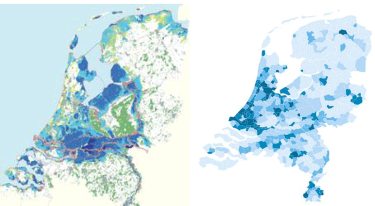
Figure 1
a (left figure) Flood risks (source: Landelijk Beheer Organisatie Risicokaart compiled by the Inter-Provincial Platform (IPO), Statistics Netherlands, CBS); b (right figure): Population density (source: Government Body for Economic Planning (CPB), 2016.
3. Implementation of Flood Risk Management Strategies in the Netherlands
3.1. The European context
FRM measures can be classified into strategies, and we refer to these strategies as flood risk management strategies (FRMSs). In this Section, we briefly discuss the distinct FRMSs, which are set out and defined in the EU Floods Directive and the accompanying Communication of the European Commission, and authoritative in all EU Member States.13 In scientific research different definitions are sometimes used, or a slightly different classification is made.14 Neither in the Floods Directive, nor in literature, is one distinct strategy preferred over another. There is no hierarchy in strategies and FRMSs, or combinations of FRMSs, are selected based on regional/local circumstances. Member States thus have a significant discretion to select the most appropriate strategy for implementing their national FRM systems.
The EU Floods Directive takes a risk-based approach: R = P × C. The flood risk in a certain area (R) can be defined as the probability that a flood incident will occur (P) in relation to the (expected) consequences of an actual flood incident in terms of casualties and economic damage (C). In that respect, the different strategies aim to reduce flood risks through decreasing the probability of flooding or mitigating its consequences. The Floods Directive identifies the following FRMSs:15
Prevention: preventing damage caused by floods by avoiding construction of houses and industries in present and future flood-prone areas; by adapting future developments to the risk of flooding; and by promoting appropriate land-use, agricultural and forestry practices;
Protection: taking measures, both structural and non-structural, to reduce the likelihood of floods and/or the impact of floods in a specific location, which may also include mitigating measures;
Preparedness: informing authorities, organizations and the population about flood risks and what to do in the event of a flood.
In the Communication of the Commission, two strategies were added:16
Emergency response: developing emergency response plans in the case of a flood; and
Recovery and lessons learned: returning to normal conditions as soon as possible and mitigating both the social and economic impacts on the affected population.
In the literature, ‘flood risk mitigation’ is also presented as a separate strategy. Fournier et al. define this strategy as ‘reducing the likelihood and magnitude of flooding and complement[ing] flood defences’.17 Driessen et al. focus their definition of flood risk mitigation on:
[D]ecreasing the magnitude or consequences of flooding through measures inside the vulnerable area. The magnitude of flooding can be decreased by retaining or storing water in or under the flood-prone area, e.g., rain water retention. The consequences can be reduced by flood zoning or (regulations for) flood-proof building.18
Thus, if not a separate strategy, mitigation could fall within the prevention strategy, but also relates to the protection strategy.19 In the Communication of the Commission, the concept of flood risk mitigation is addressed but is not explicitly defined, nor considered a separate strategy.
Flood risk management measures fit into these different FRMSs. The dominance of a specific strategy in a country determines which measures are more common than others. In the Netherlands, for instance, the protection strategy – focusing on the reduction of the probability of a flood incident – has clearly been dominant for decades, if not centuries. The most important measures in this field are the construction of storm barriers, dikes, water retention areas as well as ‘Room for the River’ projects, such as the creation of bypasses along rivers. Nonetheless, other strategies are also present and there has been a shift from a strong focus on structural flood defence towards a more diversified and coherent system of FRM (see below, Sections 4 and 5).20 In the FRM systems of other European countries, other strategies are dominant and other combinations of strategies are present, given the fact that regional/local circumstances differ throughout the EU and other political choices underpin Member States’ FRM policies.21
3.2. The implementation of FRMSs in the Netherlands
As discussed, the protection strategy has been the predominant strategy in the Dutch FRM system. Yet, all strategies are present to some extent and a considerable number of policy domains and related public actors are involved. Below, we give a detailed overview of and critical reflection on the way in which FRMSs have been implemented in the Dutch FRM system, following the order in which they are presented in the EU Floods Directive and Communications (see Section 3.1 above). In order to analyse and explain the developments and shifts in Dutch FRM in the context of climate change, it is also important to understand the broader institutional and organisational structure of Dutch FRM in general, as well as the roles and responsibilities of its key actors in relation to the distinct FRMSs. Thus, we also briefly reflect on the Dutch institutional structure.
3.2.1. The prevention strategy
The prevention strategy aims to prevent flood damage by avoiding vulnerable types of land use in present and future flood-prone areas, mainly through spatial planning measures implemented within the planning policy domain.22 Spatial planning measures to avoid flooding or to reduce the adverse effects of a flood on (economically) valuable land are not very common in the Netherlands, due to the fact that the country is densely populated and intensively used. It essentially lacks the space for the prevention strategy to be dominant in Dutch FRM. Nonetheless, the Spatial Planning Act (SPA) provides ample tools to effectuate this strategy, mainly through zoning plans, with building bans or restrictions for specific types of land use, and other spatial decisions at different levels of government. The SPA as well as most of the environmental legislation, including the Water Act, will be integrated into the new Environmental and Planning Act (EPA) that is planned to enter into force on 1 January 2023. The entry into force of this Act has been postponed several times over the past few years, however, and its entry into force in January 2023 is uncertain. Where we refer to applicable legal provisions, we will also mention the corresponding legal provisions under the future EPA. If the EPA results in relevant changes, these will be briefly mentioned.
In the Netherlands, municipalities are primarily responsible for the implementation of the SPA at the local level. The 345 Dutch municipalities form the backbone of general local democracy and have a wide range of responsibilities, including local spatial planning and the management of public space.23 Municipalities are obliged to draft zoning plans24 for their territories, through which they regulate land use and determine which types of use are and are not allowed at a specific location. This obligation also entails responsibilities relating to flood risk management.25
During the process of establishing a zoning plan, the consequences of the plan for water management have to be assessed. For example, municipalities should take flood risks into account when drafting land use and zoning plans and when making spatial decisions about which forms of land use can and cannot be allowed in a certain location.26 In that context, the relevant water management authority (WMA) is required to advise the municipality about the consequences of certain developments, and how negative impacts could be reduced. This ‘water assessment’ aims to ensure that the consequences of spatial developments for water management are taken into account in spatial decision-making.27 As the water assessment legally qualifies as mandatory ‘advice’, the municipality has to take the results of the assessment into account when establishing a zoning plan or granting a spatial permit. However, the advice of the water authority is not legally binding, so the municipality can deviate from it without the requirement to give reasons.
Although the requirement for a water assessment has led to a better understanding and more cooperation between water managers and spatial planners, the process has not been entirely effective. Recent plans to build 8,000 houses in an extremely flood-prone area near Gouda and The Hague demonstrate the ineffectiveness of water assessments as a safeguard in the process. The recent coalition agreement of the Dutch government (2022) states that Regional Water Authorities (RWAs) have to be involved in the spatial planning process at an earlier stage and that the water assessment should have a more imperative character.28 Whether this would indeed lead to better integration of FRM interests in spatial decision-making remains to be seen.
In addition to municipalities, the Dutch provinces and the Dutch central government also have responsibilities and can use legal instruments under the SPA29 as well as the EPA,30 in so far as it concerns, respectively, regional and national spatial planning issues that cannot be taken care of effectively by municipalities. The central government and provinces do, however, make use of these legal instruments to implement the prevention strategy at specific locations. For instance, the Dutch central government has established instruction rules for municipalities that prevent them from permitting land use in their zoning plans within coastal zones and floodplains that are located directly along the major rivers, which is not in accordance with the national flood risk management policy.31 Provinces occasionally make use of their power to revise the municipal zoning plan in order to execute provincial projects that include ‘Room for the River’ projects.32 For example, the provinces of Noord-Brabant and Limburg have made use of its competence to draft an ‘inpassingsplan’ (i.e. a type of zoning plan at the provincial level33) to regulate land use in the Overdiepse Polder34 and Ooijen-Wanssum respectively.35 Despite these examples, because of the highly decentralised nature of Dutch spatial planning, intervention of hierarchically higher authorities is not very common, but it does take place where and when this is needed for national or provincial interests.
3.2.2. The protection strategy
Integrated water system management and the role of WMAs
The protection strategy is dominant in Dutch FRM. This strategy is mainly implemented within the policy domain of ‘water system management’. Water system management relates to the public responsibility to pursue integrated goals36 with a particular focus on ‘water systems’ (‘watersystemen’).37 In the Netherlands, this policy domain is heavily institutionalised and has its own set of actors (WMAs) with tailored responsibilities, competences and instruments. Responsibilities and institutional aspects in this respect are further elaborated in institutional and substantive water legislation, in particular in the Water Authorities Act (‘Waterschapswet’ (WAA)) and the Dutch Water Act (‘Waterwet’ (WA)). In Dutch water system management, responsibilities are mainly divided between two types of institutions representing different layers of government. These are the Minister of Infrastructure and Water Management represented by the operational agency Rijkswaterstaat at the central level, and the RWAs at the regional/local levels.38 Both are formally considered water management authorities under the WA.
The division of responsibilities between both types of WMAs takes place on the basis of public law and on the basis of the decentralization principle. As far as the central legislature has not assigned a general responsibility for water management in a designated area to the Rijkswaterstaat, the Dutch provinces have to assign such responsibilities to the RWAs (or other public bodies).39 WMAs can also be assigned more specifically delineated responsibilities in water management. One of the key responsibilities of WMAs relevant to this article is to build and maintain flood defence structures to safeguard the hinterland from flooding. A distinction is made between primary and non-primary flood defence structures.40 The responsibility to manage both types of structures lies mainly with the RWAs, except for designated structures such as the Afsluitdijk and the Dutch Delta Works that are managed by the Rijkswaterstaat. This responsibility is quantified, and thus legally delineated by statutory flood protection standards (see below).41
For the execution of their tasks, WMAs create their own execution-oriented policies in ‘water management plans’ (‘waterbeheerplannen’) at the national and regional levels.42 For their management activities they have been assigned specific powers and instruments (both for ‘active’ management as well as for the regulation of activities via licences and general standards) on the basis of Chapters 5 and 6 WA. In drafting and executing their policies they have to take into account strategic water policies formulated in ‘water plans’ at the central level43 and, for regional waters, at the regional levels.44 Regional water plans are drafted by the Dutch provinces, which supervise the RWAs. Both the national as well as the regional water plans are also formally considered as strategic spatial policies under the SPA, enabling coordination between the policy domains of water management and spatial planning.45 Lastly, on the central level long-term, (climate-related) policy strategies about FRM and fresh water provision are developed in the course of the Dutch Delta Programme, which feeds into more concrete policy cycles.46 The division of responsibilities in Dutch water system management is schematically depicted in Figure 2.
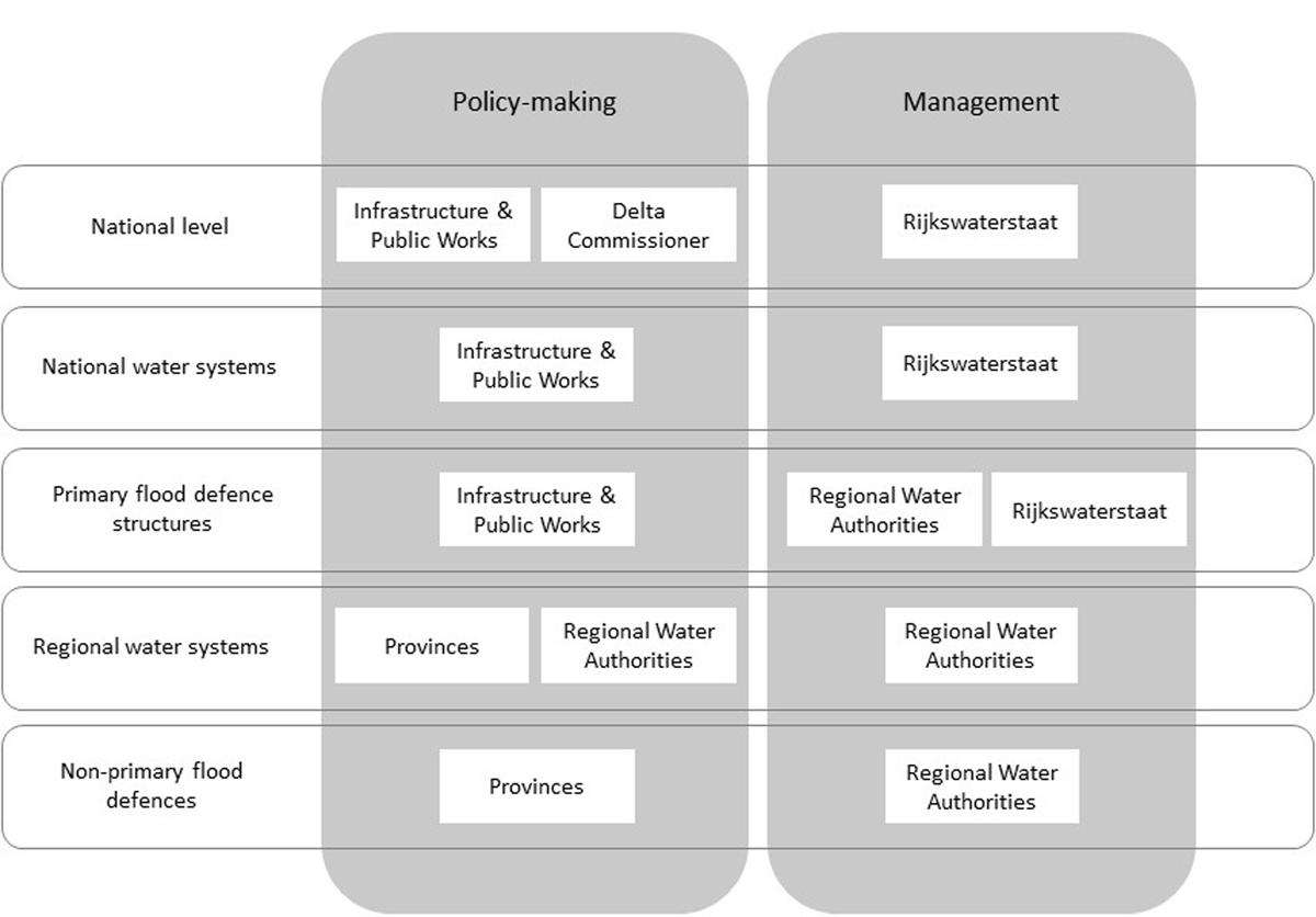
Figure 2
Division of FRM responsibilities in Dutch water system management (source: Van Doorn-Hoekveld, 2018 (n 19), p. 44).
In addition to WMAs, the WA (and the new EPA) also allocates certain responsibilities to municipalities for ‘urban water management’. Although urban water management is not considered a part of water system management, it should be considered to fall under the protection strategy as far as it aims to decrease the probability of (pluvial) flooding.47 Urban water management provides public services in collecting, transporting and processing rainwater run-off for landowners.48 Moreover, municipalities are required to take public measures within the municipal territory to preclude or limit, as far as possible, any structurally adverse influences of the groundwater level on the spatial functions of the area, as long as taking such measures is effective and is not the responsibility of a regional water authority or province.49 Policies in this respect are mainly drafted in Municipal Sewage Plans on the basis of the Environmental Management Act,50 although some municipalities have chosen to draft non mandatory water policies, often in close collaboration with RWAs.
Risk approach and safety standards for flood defence structures
In a similar way to the Floods Directive, the Dutch FRM system has adopted a risk-based approach since 2017. To further operationalise this approach, safety standards for primary and non-primary flood defence structures have been established, as well as water storage capacity standards for regional water systems. The focus of Dutch FRM is on reducing the probability of flooding, clearly implementing the protection strategy. In the WA, safety standards are established for primary flood defence structures.51 Primary flood defences protect the country from flooding from open water (i.e. the sea, large lakes and the main rivers). On the basis of these safety standards the minimal strength and height of flood defences can be determined, given all relevant circumstances and potential factors for failure. They are expressed as the yearly probability of flooding (P); a standard of, for instance, 1:3,000 means that the flood defence structure should be sufficiently strong and high so that it would statistically fail only once every 3,000 years.52 The probability is determined on the potential consequences of a flood incident in a certain area (C). With this approach, the yearly individual risk of fatality due to flooding (R) across the country may not exceed 1:100.000 (R = P × C).
In order to assess whether primary flood defence structures meet the safety standards, the legal system of the WA provides for twelve-year monitoring and reporting cycles. If a primary flood defence structure no longer meets (or is expected to meet) these standards, reinforcement measures should be taken by the responsible WMA. This would require new investments for which the Dutch Flood Protection Programme (FPP, Hoogwaterbeschermingsprogramma) and the Delta Fund are relevant. Reinforcement measures are prioritised under the FPP, whilst funding is provided through the Delta Fund which is financed by all regional water authorities and the state in equal shares. Although the focus of the FPP is on reinforcement measures, the fund could also finance other FRM projects.53 Although not all flood defence structures currently meet the safety standards (approximately 40%), the constant investment in flood defence reinforcement has ensured that there have been no serious floods over the last sixty years, the Limburg summer flood of 2021 being a notable exception. However, the area was not protected by primary flood defences as the flood of smaller rivers and brooks was caused by heavy rainfall in the only hilly area in the Netherlands.
For non-primary (or regional) flood defence structures the Dutch provinces have established safety standards in their provincial by-laws. They have also established an obligatory monitoring and reporting system, similar to the system for primary flood defence structures. The provinces have also adopted legal standards in their provincial by-laws that indicate the appropriate storage and discharge capacity of regional water systems.54 The strictness of the standards depends on land use within the designated areas: the higher the potential financial damage caused by flooding from the regional water system in a certain area, the stricter the standard for that area will be.55 For example, grasslands will be subject to a less stringent standard than urban areas. In the end, the regional water system has to be designed in such a way that the storage and discharge capacity as well as the flood defence structures are sufficient to meet the standards. This can be done by creating artificial water bodies, storage areas, enlarging water bodies by creating bypasses, increasing pumping capacity and so on.
If monitoring results indicate that a flood defence structure (both primary and non-primary) does not or is not expected to meet the standards, the competent WMA will have to indicate in its operational water management plan which reinforcement measures need to be taken to ensure that standards will be met in due time.56 Actual reinforcement of flood defence structures has to take place on the basis of a project plan that describes the reinforcement measures in full detail, including their (potential) impact on the physical environment. Such a project plan and all necessary permits and decisions (e.g. on spatial planning, construction, and nature conservation (e.g. the European Natura 2000 sites57)) are prepared via an accelerated and coordinated decision-making procedure in coordination with the competent authorities in the adjacent policy fields.58 These decisions can be appealed in a single appeals procedure in an administrative court (concentrated legal protection). If a water authority, for the execution of its project plan, is required to take measures on private property, it can impose an obligation on a private property owner to accept the measures being taken; if the authority unsuccessfully tried to come to an agreement, the landowner and the interests of the involved landowner(s) do not require expropriation.59
Water storage areas
The Netherlands has invested in building flood defence structures for centuries, but another long-held Dutch strategy has been to flood designated polders in a controlled way to prevent more densely populated areas from flooding. This is also considered to fall under the protection strategy. In the WA this common practice was formalised by the adoption of the instrument of ‘water storage areas’ (‘bergingsgebieden’). A designated water storage area aims to store water temporarily in times of high-water discharges from rivers, mostly on privately owned land.60 This can be considered a legal elaboration of the policy triplet: (1) keeping the water where it belongs; (2) storing the water in designated areas; and finally (3) discharging the water via canals and larger watercourses towards the sea.61 Storage areas are water management structures managed by the RWAs. Now, as the Netherlands also faces more and more periods of droughts due to climate change, these water storage areas will serve multiple roles, as they can also be used as a reservoir of water for periods of water shortage. Having great spatial impact, the designation of water storage areas requires strong and effective cooperation between WMAs and spatial planning authorities.
Private landowners are legally obliged (ex lege) to tolerate occasional flooding of their land.62 In connection with this obligation, restrictions on land use can be put in place, such as a landowner being prohibited from growing certain crops in a certain period of the year.63 In return, landowners will be compensated for their loss (e.g. devaluation of property, loss of income and/or actual damage as a result of inundation, such as harvest loss).64 If the land becomes useless to the landowner because of frequent inundations, expropriation should take place, but in most cases the land can still be of relevant use to the landowner. Where the land is regularly inundated but nonetheless useful, the assignment of a storage area could be a (cost) efficient way for RWAs to enlarge the storage and discharge capacity of the regional water system.
3.2.3. Preparedness and emergency response strategies
In the Netherlands, both the strategies of preparedness and emergency response, including instant short-term recovery, fall under the broader policy domain of ‘emergency management’. Therefore, we discuss these strategies together in this Section. We first address general institutional aspects and the general domain of emergency management with a focus on flooding, followed by a focused discussion of the distinct strategies.
Institutional aspects of emergency management: security regions
On the basis of the Security Regions Act (SRA), the Dutch territory is divided into 25 ‘security segions’ (‘Veiligheidsregio’s’). Security regions are obligatory forms of inter-governmental collaboration (between municipalities) with a focus on generic emergency and disaster management. Key responsibilities of the security regions are to list and assess potential emergencies and disasters and their effects, as well as to undertake preparatory planning and responsive measures and the organization of emergency management and response. Although not explicitly mentioned in the SRA, security regions have to address flood risks in their strategic and operational emergency planning. Representatives of the RWAs take part in security regions’ board meetings (but have no formal role or vote) and emergency plans are to be aligned with relevant water policies and emergency plans based on the WA. In the case of a disaster such as a flood incident, the security region’s chairperson is in charge of all emergency responders and all others involved, and has specific powers and instruments to combat the situation.65
Flood emergency management
Emergency management has been defined as the set of dedicated strategic and tactical activities that aim at reducing societally disruptive consequences of hazard events through preparative and responsive measures.66 In the literature on emergency management, three broad and overlapping phases have traditionally been distinguished.67 We define these phases and explain and elaborate on these phases in Dutch FRM in the following sub-sections. These are the phases of preparedness, response and instant recovery. Gilissen and others have applied this distinction to the field of flood emergency management as follows:
Flood emergency preparedness groups the strategic and day-to-day activities performed by emergency management organizations in the proactive (i.e. pre-event) phase; this is referred to as the ‘cold’ phase. These activities include, for instance, assessments of flood risk, flood emergency planning, training and exercising, and community engagement activities.
Flood emergency response refers to the activities initiated for a specific flood hazard event, such as instant risk mitigation (e.g. installing demountable defences), rescue operations and evacuations, continuity management and coordination of multiagency response. This reactive phase is referred to as the ‘warm’ phase.
Flood recovery activities are typically limited to the immediate aftermath of a flood event, such as sheltering displaced people, addressing primary welfare needs, and restoring critical services. This ‘cooling-down’ phase has been distinguished from, yet precedes, the longer term recovery phase, which aims at rebuilding and redeveloping flooded areas.68
In the Netherlands, flood emergency management strategies have been implemented and regulated, partly within the sectoral domain of water system management (see Section 3.2), but mainly within the domain of generic emergency management.69 In relation to other strategies (the flood protection strategy in particular), however, flood emergency management has been considered as of relatively subordinate importance.70 Moreover, regional differences have been observed as to the quality of emergency management as such and the prioritization of flood risk in relation to other hazards in particular.71 On the basis of a structured evaluation, the Dutch arrangement of flood emergency management is considered adequate, although there is room for improvement as will be discussed in Section 4.72
3.2.3.1 Preparedness
At the strategic level of emergency management, responsibilities (e.g. for emergency planning and risk prioritization) lie mainly with the boards of specialised emergency management authorities, the security regions,73 in consultation with other relevant authorities and organizations.74 Emergency profiling, assessment, planning and prioritization mostly happen on the basis of information provided through provincial hazard maps.75 Regarding flood emergency planning in particular, coordination and collaboration between security regions and RWAs is explicitly mandatory.76 Although not explicitly legally required, conducting exercises in flood emergency situations takes place at frequent intervals. Participation of all relevant actors is strongly encouraged,77 but in practice, the involvement of crisis partners and citizens in such exercises is considered to be less well established.78 This underlines the general observation that community engagement and risk awareness in Dutch FRM are rather low and should be improved.79
3.2.3.2 Response
Tactical decision-making during the ‘warm’ phase takes place through structured tiers of command and communication at different administrative and operational levels, and involves representation of all relevant authorities and primary (e.g. fire department, police, medical services) and secondary responders (‘crisis partners’) under the formal responsibility of a mayor who acts as the chair of a security region.80 This person has far-reaching powers to take all necessary measures to combat the situation, including the competence to give emergency orders and establish emergency regulations.81 A well-functioning element is the way in which citizens are being informed about a flood and the need to evacuate by means of an ‘NL-alert’, a message sent to mobile phones in addition to more traditional ways of informing the population, for instance through sirens. Apart from this generic framework, tailored provisions about ‘danger for water management structures’ have been adopted in the WA. In the case of ‘danger’,82 RWAs are allowed to take ‘all measures that are deemed necessary to cope with the situation as long as the situation requires’.83 This is considered a far-reaching, yet essential power in Dutch flood emergency management.84
Although ‘warm’ situations regarding flood incidents in the Netherlands are particularly rare, a general observation regarding the functioning of operational structures during this phase is that there is room for improvement, especially concerning the ‘upscaling’ of responsibilities and the communication between relevant actors.85 Besides an observed lack of clarity about the division of responsibilities and competences, more or less the same conclusions were drawn in the official evaluation report of a near-flood incident in the Province of Groningen in 2012.86
3.2.3.3 Short-term recovery
In the Netherlands, formal arrangements and requirements for initiating (immediate) aftercare activities are considered less well established.87 Nonetheless, recovery-based policies are increasingly established at the regional levels, and post-event activities, such as evaluations of performance and the reconstruction of damaged flood defence infrastructure,88 are more strictly regulated.89 Additionally, critical infrastructure operators (e.g., electricity network operators and drinking water companies) are legally obliged to repair their networks and continue their services as soon as reasonably possible after an emergency event.90
3.2.4. Recovery strategy
Analysis of flood risk policies shows that the recovery strategy in the Netherlands is the least developed FRMS in comparison to the other strategies.91 The Netherlands have hardly developed any structural policies on how to rebuild and redevelop areas after a major flood event. As far as the recovery strategy has been developed in Dutch FRM, it mainly concerns compensation for flood damage. In this respect the Calamities Compensation Act (CCA) is relevant, as it can be put into operation for a declared disaster (e.g. a natural earthquake or fresh water flood). When the CCA is put into operation, a specific regulation comes into force, which is created for the disaster at hand and allows individuals to apply for compensation for part of their damage. The CCA has only been put into operation six times since 1998, for example to partially compensate for damage caused by the dike breach near Wilnis (2003) and the heavy rainfall in Limburg (2021). It is funded through general means, with all Dutch citizens contributing.92 The CCA mechanism has been criticised for being too ad hoc and for the lack of clear and transparent provisions regarding the compensation of victims.93 Moreover, as the fund’s budget is rather limited, it cannot be considered a suitable instrument to compensate large groups and/or for extremely high amounts of damage.
Indeed, because of the geographical circumstances – a low-lying delta with large, flood prone areas where most of the population lives and works – the extent of damage would be unimaginably high. This is primarily why, after the 1953 floods, Dutch insurance companies made a binding agreement in which they agreed not to offer coverage of damage as a result of flooding.94 Even though this agreement can be considered to be a prohibited cartel, the insurers continue refusing coverage without a substantial contribution from the State.95 Nonetheless, in 2011, a pilot insurance policy was launched (the ‘Neerlandse’) with the goal of making flood risks insurable. Not all types of flooding were covered by the Neerlandse, as damage caused by pluvial flooding and by groundwater is excluded from the coverage because it is already covered as part of a general home contents and buildings insurance policy. The Neerlandse insurance policy was only taken up by a very small percentage of the population. Since 2020 these insurance policies have no longer been available because the risk bearer has withdrawn. Some other insurers cover flooding by secondary flood defences.96 It is unlikely that flood damage will become more widely insurable in the Netherlands in the foreseeable future.97
3.3. Conclusion
Since the Middle Ages, protection against flooding in the Netherlands has been a public responsibility. Thus, water management authorities were given the responsibility to keep the country habitable. In connection with this duty, Dutch FRM has gradually developed over time. This has led to a dominant role for water management authorities, which have implemented the protection strategy and developed tailored instruments and powers to realise structural flood defence measures to protect the hinterland against flooding. As a result of the creation of specialised authorities and the bestowal of tailored and dedicated tasks and competences upon them, other authorities’ responsibilities in FRM (and thus other FRMSs) have become somewhat subordinate, albeit all five distinct strategies are present to some extent. Moreover, there is less attention given to private responsibilities to take protective measures. Nonetheless – partly due to increasing academic and professional debate, near-flood incidents in the 1990s, changing insights about the effects of climate change, and developments in relation to the EU Floods Directive – since the turn of the century the focus on the role of other actors and strategies has increased, ushering in a new era of developments in Dutch FRM characterised by a strong drive for innovation, diversification and public involvement. We discuss these developments and their accompanying challenges in further detail below.
4. Recent Developments in Dutch FRM: Innovation through Diversification
As mentioned in Section 3, recent developments in Dutch FRM show a trend of diversification in flood risk management strategies. Innovative concepts in flood risk management, such as Room for the River, multi-layered safety and assigning storage areas, aim at integrating the traditional flood protection strategy with flood mitigation and flood prevention strategies, as well as with strategies relating to preparedness and response. Furthermore, nature-based solutions or eco-based adaptation measures98 such as the use of foreshores, double dikes and flood defence works such as the Sand Motor in front of the Dutch coast, become more and more part of traditional flood risk management, thus combining grey and green infrastructure to protect the country against floods. Thus, traditional policy domains of water management, spatial planning, emergency management and others, such as nature conservation, become more interrelated. However, these innovative concepts require more space than traditional flood defence measures. Such spatial claims require broad public support as most land is owned privately and the Netherlands is a very densely populated country.99 Authorities should also have proper legal instruments to implement planned measures, particularly if these need to be taken on privately owned land. Although these new concepts in FRM can be considered very promising, their implementation can cause legal and administrative complexity. Therefore, the implementation of such concepts requires a suitable legal basis and appropriate legal instruments to overcome potential issues. Below, we discuss three issues that could affect the effectiveness and legitimacy of innovations in Dutch FRM and that could also be relevant for other countries.
Challenge 1: fragmentation of responsibilities and coordination issues
Whereas diversification is widely considered to be a positive development in (flood) risk management, one of its downsides is that it could lead to fragmentation of responsibilities, which can be detrimental to the overall effectiveness of governance frameworks.100 As more responsibilities and competences have been divided between different actors, the need for them to communicate, to coordinate their policies, and to collaborate to achieve their shared goals is more important. The instruments that they can use for that purpose are referred to in the literature as ‘bridging mechanisms’.101 Different types can be distinguished, ranging from informal and ad hoc collaboration to legally binding forms of policy coordination and cooperation or even full integration. The ‘multi-layered safety approach’ provides a good example of diversification of FRM strategies. This approach – in brief – is built upon the generic risk approach and reflects the idea that the effects of flood protection, spatial planning (prevention and mitigation) and preparedness/response are interrelated. This means that flood risks can be managed to a desired degree (e.g. a determined legal standard) through combinations of measures in the three distinct layers (protection, spatial planning (prevention and mitigation), preparedness/response). Sharing a common goal (i.e. meeting the overarching flood safety standard), the involved authorities (RWAs, spatial planning authorities, emergency management authorities) should coordinate their policies and collaborate. The WA, SPA and SRA provide for specific instruments and provisions to foster this coordination and collaboration.102 Under the EPA, the division of tasks and competences concerning flood risk management between authorities will not change substantially, so the need for cooperation and collaboration between these authorities does not need to be debated. Besides specific instruments and provisions, the EPA includes a general obligation for authorities to collaborate and coordinate the performance of all their duties and powers under the EPA.103
Whereas multi-layered safety is an approach to manage flood risks from a probability reduction (first layer) as well as an impact reduction (second and third layer) perspective, other innovative concepts, such as Room for the River, storage areas and different nature based solutions or eco-based adaptation measures, are more project-oriented. Such projects are carried out to reduce the probability of a flood and are therefore part of the first safety layer of the multi-layered safety approach (protection). These projects require tough decisions about the use of scarce space and an integrated area-orientated approach. Therefore, the relationship between flood risk management, spatial planning and nature conservation is intensified. This can cause legal complexity and tensions between policy- and decision- making by the involved authorities, because legal responsibilities and competences on flood risk management, spatial planning and nature conservation are dispersed across different authorities.104 These authorities have to balance the involved interests in their policy- and decision-making processes within the legal scope of their responsibilities and competences. In addition, fragmentation of responsibilities and competences can be observed here, which complicates the achieving of an integrated area-orientated approach that characterises these concepts. This leads to fragmented and complex legal decision-making procedures on integrated flood risk management projects, including decisions about damage compensation.
Therefore, coordination and cooperation between involved authorities on policy- and decision-making on the project level are essential for a successful implementation. The current WA and the SPA support this coordination and cooperation with a coordinated and accelerated preparation procedure for all decisions necessary for the implementation of integrated flood risk management projects.105 Decision-making follows an accelerated preparation procedure parallel to the project decision. Depending on the character of the project, the province or the Minister is designated as the coordinating body responsible for the proper coordination of all decisions that are required for the implementation of the specific measure(s). This body also has the power to take decisions instead of the authority that is normally competent to take the decision, if this authority does not take the decision in time or in accordance with the project decision.
Under the new EPA, which is planned to come into force on 1 July 2023, the project decision of the RWA amends the municipal zoning plan directly as far as this is necessary for the implementation and operation of the project. To that extent municipalities lose their spatial planning competence. This new Act enables RWAs to integrate all implementation decisions106 into the project decision. Therefore, authorities that are normally competent to make these decisions lose this competence. Because the RWAs’ competences are functionally restricted to water management, but their project decisions can overrule competences of other authorities, the province – as a general authority – must approve project decisions established by RWAs.107 Another important change that relates to this is that the EPA will assign the task to coordinate the area-focused exercise of the duties and competences by municipalities and RWAs explicitly to the provinces. That could be an incentive for the provinces to take their role as regional area directors more seriously and improve regional coordination of policy- and decision-making by municipalities and RWAs which is essential for effective and efficient flood risk management.
The RWA’s competence to adopt project decisions is limited to its legal task to manage water systems. Because of the spatial impacts of RWAs’ water system projects, these projects have to be approved by the province, as provinces are responsible for regional spatial planning. The approval of project decisions from RWAs by the province therefore will become more important. As far as projects also concern interests that are not connected with the water management task of the RWA (e.g. construction of houses or business parks), the RWA is not competent to take project decisions for the project. In that case the municipality, the province or the central government are competent to take the project decision in the exercise of their spatial planning tasks on a local, regional or national level. If the province or the central government decide to take the project decision, the RWA loses its competence for that part of the project which relates to its water management tasks to take a project decision for the water related part of the mixed project.
Challenge 2: participation issues
There are many interests, stakeholders, authorities and policy areas involved in the application of these flood risk management-concepts. This requires a thorough and timely participation process. The new EPA increases participation opportunities at an early stage for projects concerning the construction or reinforcement of primary flood defence structures. Before the project decision is adopted, an extra preparatory procedure must be followed.108 This procedure starts with an intention to explore solutions for the problem within the physical environment, in case primary flood defence structures do not comply with the applicable safety standards (within a foreseeable period). During this exploration phase everyone can propose solutions for the problem and can request the RWA to have these solutions assessed by an independent expert.109 The exploration phase ends with a decision on the preferred solution by the RWA (the preferential decision), based on all assessments, including an environmental impact assessment, and the results of the participation process. This preferential decision is of a policy nature and is therefore not open to appeal. The preferential decision has to be developed into a (draft of a) concrete project decision, which is the start of the formal legal procedure. This extra preparatory procedure is mandatory for primary flood defence structures110 and optional for other water management structures.
Challenge 3: spatial claim issues
The innovative flood risk management concepts discussed here require large portions of land that are often owned by private parties. Therefore, the authorities that plan to implement these concepts on privately owned land need sufficient legal authority, such as the competence to impose obligations to allow the construction of public water works. In specific cases, the interests of landowners might even require expropriation. The current WA111 and Expropriation Act provide regulatory mechanisms for the realisation of projects of public interest on private owned land. Under the new EPA these instruments will be integrated (and preserved),112 but the expropriation instrument will be significantly modified. The most important modification is that the authority that takes the decision on the realization of the project or spatial development, also takes the decision to expropriate,113 with the proviso that this decision must be officially confirmed in an administrative court procedure.114 The civil court only determines whether the private parties should be (fully) compensated. Under the current Expropriation Act, the decision to expropriate is taken by the national government at the request of the authority that takes the decision on the realization of the project or spatial development, and is substantively tested in a civil court procedure in which the (full) compensation is also determined.
5. Discussion and Conclusions: the Way Forward
In this article we have discussed developments in Dutch FRM against the background of increasing climate risks and the Dutch societal, political and academic debate about adaptation to climate change. Using flood defences to prevent existing land from flooding and to reclaim land from the water has been an approved method in the Netherlands for centuries. The dominance of the flood protection strategy is therefore understandable. Confronted with the (expected) effects of climate change, as well as societal and physical changes, however, recent shifts in flood risk governance can be observed. Since the mid-1990s, the discourse gradually changed from merely constructing ‘grey’ or ‘hard’ and straight flood defences (dikes, storm surge barriers) to approaches that combined flood defences with creating more room for water. This eventually led to the ‘Room for the River’ programme, in which retention areas and sub-channels were constructed to create more space for water in times of high river discharges to reduce the probability of flooding. These developments, in other words, broadened the scope within the protection strategy.
These developments preceded the introduction of a more integrated risk-based approach in Dutch FRM, and consequently the development of the policy concept of ‘multi-layered safety’. This flood risk approach is in line with, and actually promoted by, the EU Floods Directive. It opens the door to different responses to reduce flood risks as it builds on the assumption that, apart from decreasing the probability of flood events (protection), flood risks can also be reduced by decreasing the potential consequences of flooding through spatial measures (e.g. building restrictions and/or building requirements, elevation, flood-proofing or relocation of houses, and the compartmentalization of the areas) or proactive emergency planning (e.g. flood forecasting and warning systems, evacuation planning). Thus, gradually more emphasis was placed on prevention, mitigation and preparedness as independent (yet interdependent) FRM strategies with promising additional or direct effects in Dutch FRM. Although there are practical examples of situations in which this new policy approach has been applied, up until today the protection strategy is still dominant, as can also be concluded from the (relatively) new system of flood probability standards in the WA.
It is yet uncertain whether the new approach, which leaves more room for determining which (combinations of) strategies in concrete situations will be deployed to reduce flood risks, will become dominant in future Dutch FRM. Nonetheless, these recent developments have shown a shift in the way of thinking in Dutch FRM. This could entail a shift in normative principles underpinning Dutch FRM, from uniform ‘equal risks in water safety for all’ based on regional solidarity, towards a more differentiated, nuanced approach where there is more room for regional differentiation and a more prominent role for private responsibilities. Moreover, other policy domains – spatial planning, emergency management, nature conservation – are becoming more important in FRM. This affects the dominant position of public water management and existing expertise in FRM and will also raise challenges. A diversification in strategies leads to the involvement of a larger number of public institutions (such as municipalities, provinces and emergency management authorities) with different responsibilities and competences in FRM. This increases the need for coordination and cooperation between those actors. At the same time, measures like ‘Room for the River’ require more space than traditional protection measures. In addition, the relationship with and involvement of non-governmental actors who own property in flood prone areas will require more attention. This will increase the need for better public participation, and also for sufficient legal powers to impose obligations to allow FRM measures to be taken on privately owned land and, if needed, for expropriation.
Innovative FRM concepts have clear relationships with other policy areas, such as nature protection and spatial planning, and therefore require an integrated area-oriented approach. To conclude this article with a glimpse into the (near) future, it is relevant to investigate whether the new EPA will provide a more effective framework to deal with such issues. Although this Act is based on such an approach, the distribution of tasks and competences among authorities involved in FRM and their content remains largely the same. Cooperation and coordination between these authorities will therefore become even more important in future FRM. The provincial authority will have a key role in this, because the EPA expressly assigns the task of ‘regional area director’ to the province and equips the provincial authority with legal instruments to fulfil this task. Due to climate change and the new FRM concepts, the (spatial) impact on the environment and privately owned land will increase. Therefore, citizen participation of landowners and other local stakeholders will become more important in future FRM. The EPA can play a facilitating role in this regard, because one of its objectives is to improve citizen participation in environmental policy- and decision-making. Expectations should not be set too high, because the legal anchoring of participation is relatively weak. It is therefore especially important that authorities that are responsible for FRM take citizens seriously in their policy- and decision-making and are open to alternatives.
To conclude, we argue that too strict a focus on decreasing the probability of flood events (protection) could be detrimental to the effectiveness of FRM in the longer run, in particular considering the challenges of climate change, changing precipitation patterns, sea level rise and increasing river run-off. Further diversification of FRMSs and measures and increasing interconnectedness between them is needed to make Dutch FRM fit for the future. In this way, we will be able to continue our age-old battle against water, but will also be able to intensify and speed up the spatial adaptation of our country to the predicted impacts of climate change.
Nous maintiendrons!115
Notes
[1] IPCC, ‘Climate Change 2021: The Physical Science Basis. Contribution of Working Group I to the Sixth Assessment Report of the Intergovernmental Panel on Climate Change’ (report) (Cambridge University Press 2021); KNMI, ‘KNMI Klimaatsignaal’21: hoe het klimaat in Nederland snel verandert’ (De Bilt 2021).
[2] H.K. Gilissen, ‘The Integration of the Adaptation Approach into EU and Dutch Legislation on Flood Risk Management’ (2015) Journal of Water Law, 24(3/4), 157–165; H.K, Gilissen, Adaptatie aan klimaatverandering in het Nederlandse waterbeheer: Verantwoordelijkheden en aansprakelijkheid (Kluwer 2013).
[3] Dries Hegger and others, ‘Toward more flood resilience: Is a diversification of flood risk management strategies the way forward?’ (2016) 21 Ecology and Society 52: Herman Kasper Gilissen and others, ‘A framework for evaluating the effective of flood emergency management systems in Europe’ (2016) 21 Ecology and Society 27; Herman Kasper Gilissen and others, ‘Bridges over Troubled Waters: An Interdisciplinary Framework for Evaluating the Interconnectedness within Fragmented Flood Risk Management Systems’ (2016) 25 Journal of Water Law 12; Sally Priest and others, ‘The European Union approach to flood risk management and improving societal resilience: lessons from the implementation of the Floods Directive in six European countries’ (2016) 21 Ecology and Society 50; Willemijn van Doorn-Hoekveld and others, ‘Distributional effects of flood risk management - a cross-country comparison of preflood compensation’ (2016) 21 Ecology and Society 26; Peter Driessen and others, ‘Toward more resilient flood risk governance’ (2016) 21 Ecology and Society 53; Cathy Suykens and others, ‘Dealing with flood damages: will prevention, mitigation, and ex post compensation provide for a resilient triangle?’ (2016) 21 Ecology and Society 1; Dries Hegger, Peter Driessen and Marloes Bakker (eds), ‘A view on more resilient flood risk governance: key conclusions from the STAR-FLOOD project’ (Utrecht 2016) <https://dspace.library.uu.nl/bitstream/handle/1874/329024/D6_4_Final_document_with_main_research_results.pdf?sequence=1> (last accessed: 18 October 2022); Maria Kaufmann and others, ‘Analysing and evaluating flood risk governance in the Netherlands: Drowning in safety?’ (September 2015) <https://dspace.library.uu.nl/bitstream/handle/1874/329018/Analysing_and_evaluating_flood_risk_governance_in_The_Netherlands_08.03.16.pdf?sequence=1> (last accessed: 18 October 2022); Mark Wiering and others, ‘The rationales of resilience in English and Dutch flood risk policies’ (2015) 1 Journal of Water and Climate Change 38; Dries Hegger and others, ‘Assessing Stability and Dynamics in Flood Risk Governance: An Empirically Illustrated Research Approach’ (2014) 28 Water Resources Management 4127.
[4] Art 4.9 Dutch Water Act, see https://www.government.nl/topics/delta-programme (last accessed: 10 October 2022).
[5] Multi-layered safety is an approach in Dutch FRM that is described in non-legally binding policy documents, such as the National Environmental Strategy (2020) (Ministry of Internal Affairs, 2020), 57. See for instance Sebastiaan van Herk and others, ‘Process and management of integrated flood risk management: exploring the multi-safety approach for Dordrecht, The Netherlands’ (2014) 5 Journal of Water and Climate Change 100.
[6] For more information about the former development see Ministry of Infrastructure and the Environment, Nationale Adaptatie Strategie 2016 (report); Runhaar, H. A. C. and others, ‘Prepared for climate change? A method for the ex-ante assessment of formal responsibilities for climate adaptation in specific sectors’(2016) Regional Environmental Change, 16(5), 1389–1400 https://doi.org/10.1007/s10113-015-0866-2; and Herman Kasper Gilissen and others, ‘The Climate Resilience of Critical Infrastructural Network Sectors: An interdisciplinary method for assessing formal responsibilities for climate adaptation in critical infrastructural network sectors’ in S. Maljean-Dubois (ed), The Effectiveness of Environmental Law (Intersentia 2017).
[7] Commissie waterbeheer 21e eeuw, ‘Waterbeleid voor de 21e eeuw. Geef water de ruimte en de aandacht die het verdient’ (Den Haag 2000); Kabinetsnota, ‘Anders omgaan met water Waterbeleid voor de 21e eeuw’ (Den Haag 2000); Kabinetstandpunt Ruimte voor de Rivier, (Den Haag 2000). De 3e Kustnota: Traditie, Trends en Toekomst, (Den Haag 2000). See for these documents: https://puc.overheid.nl/rijkswaterstaat/doc/PUC_23226_31/ (last accessed: 18 October 2022) ‘Nota Ruimte: ruimte voor ontwikkeling’, (Den Haag 2006), chapter 6 https://puc.overheid.nl/rijkswaterstaat/doc/PUC_142322_31/ (last accessed: 18 October 2022). See for the developments since 2011: the annual revised National Delta Programme, more specifically the Deltaplans Watersafety and Spatial Adaptation https://www.deltaprogramma.nl/ (last accessed: 18 October 2022).
[9] CBS, ‘Regionale kerncijfers Nederland’ (24 August 2022) https://opendata.cbs.nl/statline/#/CBS/nl/dataset/70072ned/table?dl=65A8 (last accessed: 18 October 2022).
[10] Ahjond Garmestani and others, ‘The Role of Social-Ecological Resilience in Coastal Zone Management: A Comparative Law Approach to Three Coastal Nations’ (2019) 7 Frontiers in Ecology and Evolution 410.
[12] As well as in different Eastern provinces of Belgium and North Rhine-Westphalia and Rhineland Palatinate in Germany.
[13] Directive of the European Parliament and Council 2007/60/EC of 23 October 2017 on the assessment and management of flood risks (Flood Directive), [2007] OJ L288/27; Commission, ‘The Water Framework Directive and the Floods Directive: Actions towards the “good status” of EU water and to reduce flood risks’ COM (2015) 120 final.
[15] The strategies are defined properly in the Communication of the Commission: see Commission, ‘Flood risk management. Flood prevention, protection and mitigation’ COM (2004) 472 final.
[17] Marie Fournier and others, ‘Flood risk mitigation in Europe: how far away are we from the aspired forms of adaptive governance?’ (2016) 21 Ecology & Society 49.
[19] Willemijn van Doorn-Hoekveld, Distributional Effects of EU Flood Risk Management and the Law. The Netherlands, Flanders and France as case studies (Utrecht University 2018) 4.
[23] See Marlon Boeve and others, Omgevingsrecht (6th edn, Europa Law Publishing 2019) in particular chs 1.3.2 and 5.4.
[24] Art 3.1(1) SPA. The zoning plan will be replaced by the physical environmental plan, that can include not only spatial planning rules, but also other rules relating to the physical environment (art 2.4 in conjunction with art 4.1(1) and 4.2(1) EPA (new)).
[25] See Frank Groothuijse, Water weren. Het publiekrechtelijke instrumentarium voor de aanpassing en bescherming van watersystemen ter voorkoming en beperking van wateroverlast en overstromingen (Instituut voor Bouwrecht 2009); Herman Kasper Gilissen, J. Kevelam and H.F.M.W. van Rijswick, Water en Ruimte - De bescherming van watersysteembelangen in het ruimtelijk spoor (Berghauser Pont Publishing 2014).
[26] Ss 2.3, 2.4 and 2.11 General Regulations on Spatial Planning Decree (‘Besluit algemene regels ruimtelijke ordening’) (para 5.1.3 Environmental Quality Decree (new)). See also: Groothuijse (n 25).
[27] On the basis of art 3.1.6 of the Spatial Planning Decree, the water assessment is compulsory in relation to zoning plans (‘bestemmingsplannen’) and spatial permits for specific projects that deviate from these plans (‘omgevingsvergunningen’) (art 5.37 and art 8.0b (1) sub a Environmental Quality Decree (new)).
[28] This means that that the recommendations provided in water assessments should be implemented and enforced; Coalitieakkoord 2021–2025 VVD, D66, CDA; and see Christen Unie, ‘Omzien naar elkaar, vooruitkijken naar de toekomst’ (15 December 2021) www.kabinetsformatie2021.nl (last accessed: 18 October 2022).
[31] See ss 2.3, 2.4 and 2.11 General Regulations on Spatial Planning Decree (‘Besluit algemene regels ruimtelijke ordening’) (para 5.1.3 Environmental Quality Decree (new)).
[33] See art 3.26 SPA. The provincial inpassingsplan will be replaced by the provincial projectbesluit (project decision) under the EPA. See s 5.2, arts 5.44, 5.44a and 5.52(1) EPA (new).
[34] Staatscourant 18 June 2009, 110. See for more information: https://www.dutchwatersector.com/news/room-for-the-river-first-dairy-farmer-moves-to-new-farm-on-6-m-high-mound-in-overdiepse-polder (last accessed: 26 October 2022).
[35] Staatscourant 25 May 2016, 27101. See for more information: https://www.ooijen-wanssum.nl/english/
[36] This approach integrates flood risk management, other types of water quantity management and drainage, as well as water quality management, wastewater treatment and allowing water systems to fulfil societal functions (e.g. shipping, fishing and drinking water extraction) in one legal and governance framework.
[37] A water system comprises a coherent combination of surface water and groundwater bodies, as well as water storage areas, flood defence structures and ancillary structures (art 1.1(1) WA and art. 1.1(1) EPA, in conjunction with the Annex EPA (new)).
[38] The current 21 Dutch RWAs arose originally out of thousands of community-based institutions, which over time institutionalised into regional, public water authorities. These are forms of so-called functional decentralization, which means that they have specific and limited responsibilities (water management) to be carried out in a designated area. In fulfilling their tasks, these democratically legitimised institutions have legislative power and the authority to levy taxes and employ executive coercion. See for a more comprehensive discussion of the Dutch RWAs and their tasks: Remco Nehmelman, ‘Institutional governance aspects of water management: subsidiarity and decentralisation – the Dutch approach’ (2014) 24 The Journal of Water Law 134; Marleen van Rijswick and Herman Havekes, European and Dutch Water Law (Europa Law Publishing 2012) 146-150.
[39] Arts 1(2) and 2(1) and (2) RWA Act and art 3.1 and 3.2 WA (arts 1(2) and 2(1) RWA and art 2.17(1) sub a and 2.18(2) EPA (new)). Willemijn van Doorn-Hoekveld and Frank Groothuijse, ‘Analysis of the strengths and weaknesses of Dutch water storage areas as a legal instrument for flood risk prevention’ (2017) 14 Journal for Environmental & Planning Law 76.
[40] Primary flood defence structures offer protection against flooding from ‘open water’ (‘buitenwater’, i.e. the North Sea, the Wadden Sea and the major rivers and lakes). Non-primary flood defence structures offer protection against flooding from the regional water system, i.e. surface water bodies that do not qualify as ‘open water’.
[41] Currently, these standards have a statutory basis in art 2.2 in conjunction with Annexes I, II and III (primary flood defence structures) WA and art 2.4 WA (regional flood defence structures). Under the new Environmental and Planning Act (planned entry into force by 1 January 2023), these standards will have a basis in art 2.15(1) sub d EPA (new) and will be established in para 2.1.1 in conjunction with Annex II(A) and Annex II(B) of the Environmental Quality Decree (‘Besluit kwaliteit leefomgeving’) for primary flood defence structures and art 2.13(1) sub a EPA (new) for regional flood defence structures.
[45] Art 4.4(1) WA. Groothuijse (n 25). The strategic water and spatial planning plans will be integrated into a national and regional environmental strategy (s 3.1 EPA (new)).
[46] Strategic water plans at the central level should contain a ‘vision’ on desired developments in flood and drought risk management for the coming forty years (art 4.1(1)(d) WA). This is generally seen as a statutory obligation to develop climate adaptation policies in Dutch water management. See Herman Kasper Gilissen, ‘The Integration of the Adaptation Approach into EU and Dutch Legislation on Flood Risk Management’ (2015) 24(3/4) Journal of Water Law 157–165.
[50] Art 4.22 Environmental Management Act. Under the EPA the establishment of a Municipal Sewage Plan is no longer mandatory. The Municipal Executive may establish this plan voluntarily as a non-mandatory programme (art 3.14 EPA new). This is not in line with EU obligations following from the Floods Directive.
[51] Art 2.2 and Annex II WA; art 2.15(1) sub d EPA (new) in conjunction with para 2.1.1 Environmental Quality Decree (new).
[52] Thomas Hartmann and others (eds.), Flood Resilience of private properties (1st edn, Routledge 2021); Cathy Suykens and others, ‘Sticks and carrots for reducing property-level risks from floods: an EU–US comparative perspective’ (2019) 44 Water International 622; Chris Seijger and others, ‘Functions of OECD Water Governance Principles in assessing water governance practices: assessing the Dutch Flood Protection Programme’ (2018) 43 Water International 90; Herman Kasper Gilissen and others, ‘De nieuwe systematiek van veiligheidsnormering voor primaire waterkeringen: niet eenvoudiger, wel beter’ (2017) 142 Tijdschrift voor Bouwrecht 946.
[57] Natura 2000 is a coordinated network of protected areas for rare and threatened species and habitats in the European Member States, the legal basis for which is the Habitats Directive, [1992] OJ L206/7.
[61] This final leg of the threefold policy has multiple implications. For more information, see van Doorn-Hoekveld and Groothuijse (n 39).
[63] In a zoning plan (art 3.1(1) SPA) (art 4.2(1) EPA (new)) or in a regulation of the RWA (art 78(1) RWA, art 2(2) WAA, in conjunction with art 3.2 WA) (art 2.5 EPA, art 4.1(1) EPA (new), art 78(1) RWA, art 2(2) WAA in conjunction with art 2.17(1) sub a under 1 EPA (new)).
[64] Art 5.26 in conjunction with art 7.14 and 7.15 WA (art 10.3(4) in conjunction with art 15.13 EPA (new)). See Willemijn van Doorn-Hoekveld, ‘Compensation in Flood Risk Management with a Focus on Shifts in Compensation Regimes regarding Prevention, Mitigation and Disaster Management.’ (2014) 10 Utrecht Law Review 216; van Doorn-Hoekveld and others (n 3); Willemijn van Doorn-Hoekveld, ‘Equal distribution of burdens in flood risk management. The application of the “égalité principle” in the compensation regimes of the Netherlands, Flanders and France’ (2017) 10 Review of European Administrative Law 81; Willemijn van Doorn-Hoekveld and Frank Groothuijse, ‘Analysis of the Strengths and Weaknesses of Dutch Water Storage Areas as a Legal Instrument for Flood-risk Prevention’ (2017) 14 Journal for European Environmental & Planning Law 76.
[66] Herman Kasper Gilissen and others, ‘A framework for evaluating the effectiveness of flood emergency management systems in Europe’ (2016) 21 Ecology & Society 27. This section is largely based on this publication.
[67] Alec Baird and others, ‘Towards an explanation and reduction of disaster proneness’ (1975) Occasional Paper No.11, University of Bradford.
[71] Hoekstra Committee, Evaluatiecommissie Wet veiligheidsregio’s en het stelsel van Rampenbestrijding en Crisisbeheersing: Eindrapportage (Ministerie van Veiligheid en Justitie 2013); Gilissen (n 66).
[73] On the basis of art 8 SRA, the Dutch territory has been subdivided into 25 security regions. See https://www.nctv.nl/organisatie/veiligheidsregios/index.aspx (last accessed: 18 October 2022).
[77] Herman Havekes and Peter de Putter, Wegwijzer Waterwet – Een praktische handleiding (Kluwer 2014).
[79] Kaufmann (n 3); OECD, Water Governance in the Netherlands: Fit for the Future? OECD studies on water, (OECD Publishing 2014).
[82] The term ‘danger’ is defined as ‘circumstances that cause an immediate and urgent threat to the well-functioning of one or more water management structures’. See art 5.28 WA.
[85] Hoekstra Committee 2013 (n 71); Erwin Muller, ‘Crisis en recht – Naar een integrale.
Crisisbeheersingswet?’ in Erwin Muller and others (eds), Crises, rampen en recht: Preadviezen NJV (Deventer 2014).
[86] Johan Haasjes and others, De dijk staat op springen. Hoog water in de Veiligheidsregio Groningen. De evaluatie en bevindingen (Veiligheidsregio Groningen 2012) (powerpoint presentation), https://docplayer.nl/18984450-De-dijk-staat-op-springen.html; COT Instituut voor Veiligheids- en Crisismanagement, Een crisis van ongekende omvang. Leerevaluatie watercrisis 2021 (Waterschap Limburg, 6 January 2022) <https://www.waterschaplimburg.nl/actueel/nieuws/@6942/leerevaluatie-waterschap-limburg> (last accessed: 18 October 2022).
[90] Hens Runhaar and others, ‘Prepared for climate change? A method for the ex-ante assessment of formal responsibilities for climate adaptation in specific sectors’ (2016) 16 Regional Environmental Change 1389. Herman Kasper Gilissen and others, ‘The Climate Resilience of Critical Infrastructural Network Sectors – An interdisciplinary method for assessing formal responsibilities for climate adaptation in critical infrastructural network sectors’ in Sandrine Maljean-Dubois (ed) The Effectiveness of Environmental Law (Intersentia 2017) 22.
[93] Véronique Bruggeman, ‘A critical comparison of the main compensation mechanism for victims of natural catastrophes in Belgium and the Netherlands. With a law and economics twist’ (2011) 8(1) Journal for European Environmental & Planning Law 46–61. http://dx.doi.org/10.1163/187601011X559718, p. 59 (last accessed: 18 October 2022); Ton Hartlief, ‘Privaatrecht in nood’ in E R Muller and others, (eds), Crises, rampen en recht (Kluwer 2014) 65–194.
[94] Verbond van Verzekeraars, Adviesrapport Overstromingen (2018) 19 (www.verzekeraars.nl, last accessed: 26 October 2022).
[96] Since 2020 and 2021, many insurers have expanded the coverage of private buildings and contents insurance to include damage caused by flooding of non-primary flood defences. The policies do not cover damage caused by flooding of primary flood defences.
[97] Only one insurer also covers damage caused by flooding of primary flood defences, but only for houses with a reconstruction value of €500,000 or more and contents with a new value of €100,000 or more (Turien & Co).
[98] See for a discussion on the two concepts: https://www.twn.my/title2/climate/info.service/2022/cc220301.htm (last accessed: 18 October 2022).
[99] Madeline Taylor, ‘Planning the Energy Transition: A comparative examination of large-scale solar energy siting on agricultural land in Australia’. Madeline Taylor, ‘Regulating Land Use Risks in the Energy Transition: A comparative examination of solar energy siting on agricultural land in Australia’ (2022) 18(2) Utrecht Law Review.
[104] See: https://kbase.ncr-web.org/all-risk/storylines-overview/ https://storymaps.arcgis.com/stories/c948388379ed4180ac7f63489cc4d12f (last accessed: 18 October 2022).
[105] Art 5.8–5.12 WA (para 5.2 more specifically art 5.45, art 5.46(1) sub f and (2) and para 5.2.3 EPA (new)).
Competing Interests
The authors have no competing interests to declare.