
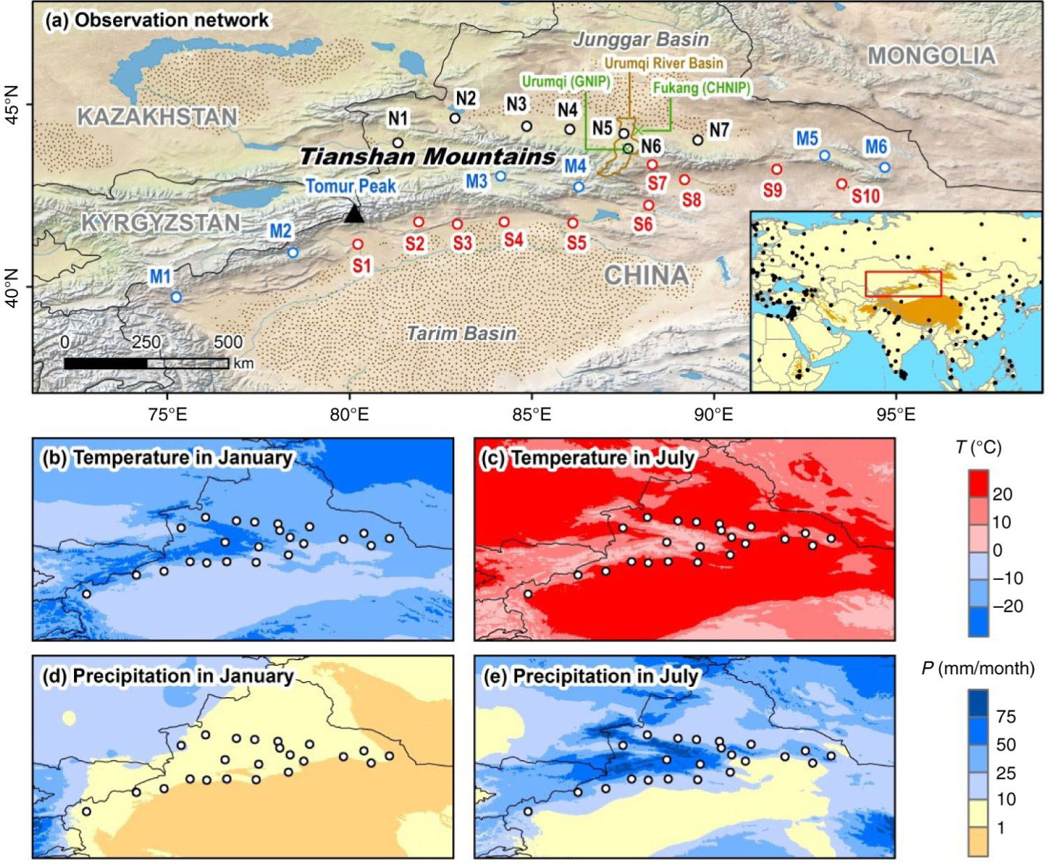
Fig. 1
(a) Map showing the locations of sampling stations (empty circles) around the Tianshan Mountains, arid central Asia. The sampling stations are labelled as follows: Northern slope: Yining (N1), Jinghe (N2), Kuytun (N3), Shihezi (N4), Caijiahu (N5), Urumqi (N6) and Qitai (N7); Mountains: Wuqia (M1), Akqi (M2), Bayanbulak (M3), Balguntay (M4), Barkol (M5) and Yiwu (M6); and Southern slope: Aksu (S1), Baicheng (S2), Kuqa (S3), Luntai (S4), Korla (S5), Kumux (S6), Dabancheng (S7), Turpan (S8), Shisanjianfang (S9) and Hami (S10). The satellite-derived land cover is acquired from Natural Earth (www.naturalearthdata.com), and the distribution of deserts (scattered area) is modified from Wang et al. (2005). The small map shows the spatial distribution of existing isotope stations in the GNIP database (observation period no less than 12 months for δ 18O value; IAEA/WMO, 2014), and the areas higher than 2000 m a.s.l. are coloured in brown. (b–e) Spatial distributions of monthly air temperature and precipitation in January (left column) and July (right column) during 1950–2000. The long-term climatology is based on the WorldClim-Global Climate Data Version 1.4 (Hijmans et al., 2005; www.worldclim.org).
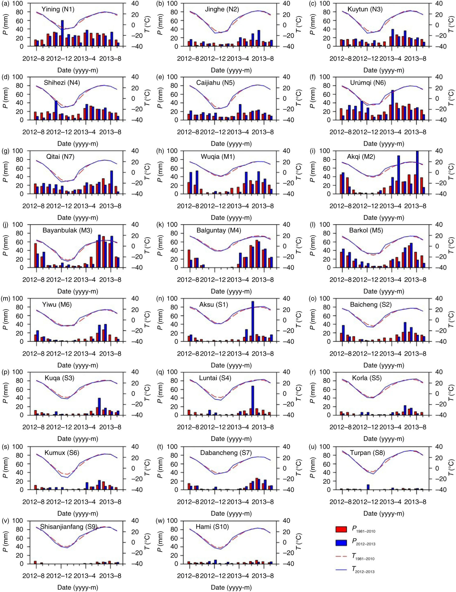
Fig. 2
Monthly variation of air temperature and precipitation for each sampling station around the Tianshan Mountains from August 2012 to September 2013 (blue) and from 1981 to 2010 (red).
Table 1. Latitude, longitude, altitude, long-term climatology (T – air temperature, P – precipitation amount, E – pan evaporation and RH – relative humidity) from 1981 to 2010 and sample number (n) for each sampling station in this study
Northern slopeYining (N1)43°57′81°20′662.59.5298.91556.86590Jinghe (N2)44°37′82°54′320.18.2112.11481.56242Kuytun (N3)44°24′84°52′562.08.5183.51950.25947Shihezi (N4)44°19′86°03′442.97.8226.91483.86474Caijiahu (N5)44°12′87°32′440.56.5153.81964.36258Urumqi (N6)43°47′87°39′935.07.3298.62015.05875Qitai (N7)44°01′89°34′793.55.4200.91810.56144MountainsWuqia (M1)39°43′75°15′2175.77.7188.72738.64565Akqi (M2)40°56′78°27′1984.96.8237.71745.85262Bayanbulak (M3)43°02′84°09′2458.0−4.2280.51132.47096Balguntay (M4)42°44′86°18′1739.07.0220.41829.34260Barkol (M5)43°36′93°03′1677.22.7230.51701.65553Yiwu (M6)43°16′94°42′1728.64.2104.42100.54423Southern slopeAksu (S1)41°10′80°14′1103.810.880.41948.05739Baicheng (S2)41°47′81°54′1229.28.2136.61335.06552Kuqa (S3)41°43′82°58′1081.911.376.72176.94940Luntai (S4)41°47′84°15′976.111.678.62043.04825Korla (S5)41°45′86°08′931.512.059.22669.84622Kumux (S6)42°14′88°13′922.49.859.93049.24228Dabancheng (S7)43°21′88°19′1103.56.976.72491.95112Turpan (S8)42°56′89°12′34.515.115.42533.73921Shisanjianfang (S9)43°13′91°44′721.412.522.66214.4326Hami (S10)42°49′93°31′737.210.343.72415.34518
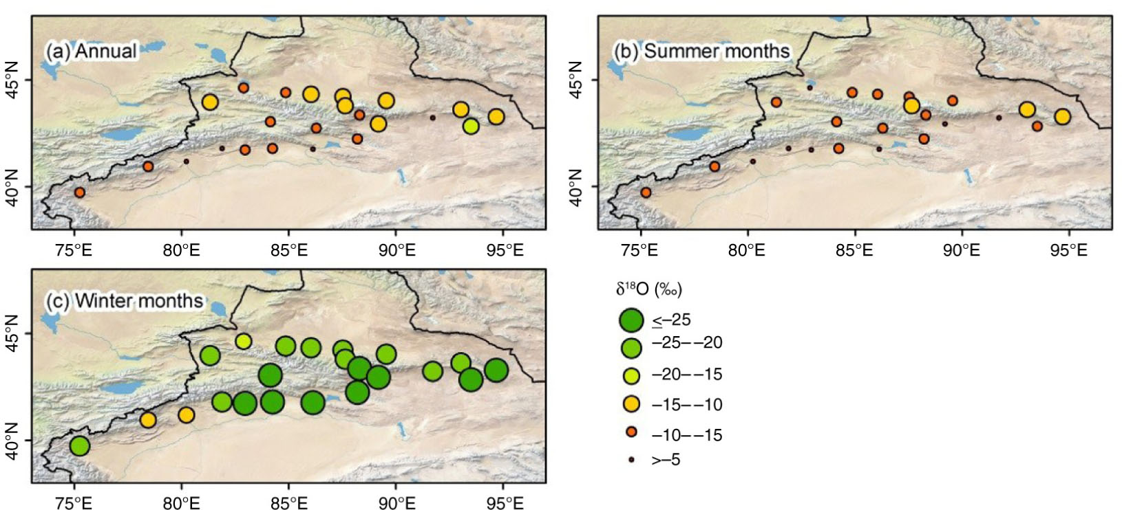
Fig. 3
Spatial distribution of precipitation-weighted δ 18O for each station around the Tianshan Mountains from August 2012 to September 2013. (a) Annual, (b) summer months and (c) winter months.
Table 2. Precipitation-weighted values of δD, δ 18O and D-excess for each station from August 2012 to September 2013
Station AnnualSummer monthsWinter monthsAnnualSummer monthsWinter monthsAnnualSummer monthsWinter months AnnualSummer monthsWinter monthsYining (N1)−99.7−47.4−160.7−13.6−7.1−21.18.89.67.9905832Jinghe (N2)−37.2−35.7−142.8−5.0−4.9−16.33.23.4−12.642402Kuytun (N3)−65.7−42.9−191.9−9.6−6.9−24.510.912.14.347389Shihezi (N4)−84.4−46.1−171.3−12.1−7.1−23.412.510.916.2745519Caijiahu (N5)−83.2−56.7−164.5−11.8−8.4−22.010.910.611.6583523Urumqi (N6)−92.1−63.9−161.4−13.6−10.5−21.316.619.79.1754134Qitai (N7)−73.1−54.9−152.7−11.1−9.1−20.316.017.59.4442915Wuqia (M1)−34.5−28.5−170.4−6.1−5.4−23.114.414.414.465614Akqi (M2)−39.8−38.3−96.3−6.4−6.2−13.411.211.211.162593Bayanbulak (M3)−52.6−46.8−203.4−8.4−7.7−26.214.314.66.496879Balguntay (M4)−52.1−52.1N.A.−7.8−7.8N.A.10.310.3N.A.60600Barkol (M5)−88.8−73.8−187.7−12.3−10.5−24.29.49.95.9533419Yiwu (M6)−73.5−70.6−198.5−10.5−10.1−28.410.710.228.823212Aksu (S1)−28.5−27.5−91.3−4.7−4.6−11.99.29.33.539354Baicheng (S2)−25.2−14.8−193.5−3.9−2.6−24.15.96.3−1.052457Kuqa (S3)−38.6−17.0−194.5−5.7−2.9−25.87.26.611.840355Luntai (S4)−63.5−45.2−193.3−9.3−7.0−25.010.611.17.125241Korla (S5)−33.5−11.1−202.4−4.5−1.6−26.82.61.411.822166Kumux (S6)−63.3−38.3−198.5−8.6−5.5−25.35.25.53.628244Dabancheng (S7)−52.6−46.1−268.5−8.3−7.5−35.313.613.514.312111Turpan (S8)−105.3−34.3−205.4−12.1−2.5−25.6−8.6−14.4−0.521174Shisanjianfang (S9)−33.3−18.0−164.9−3.6−1.6−20.4−4.9−5.3−1.4642Hami (S10)−144.2−46.8−210.7−18.6−5.5−27.64.9−2.910.21899
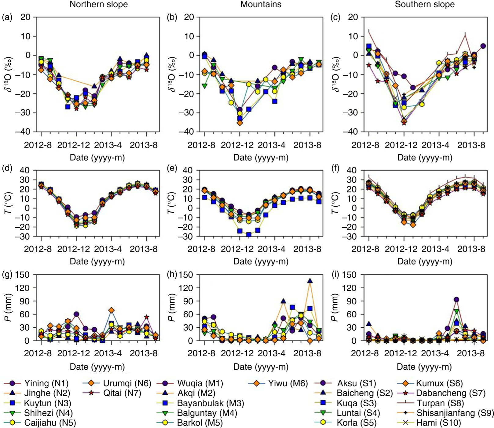
Fig. 4
Monthly variation of precipitation δ 18O, air temperature and precipitation amount for each station around the Tianshan Mountains from August 2012 to September 2013.
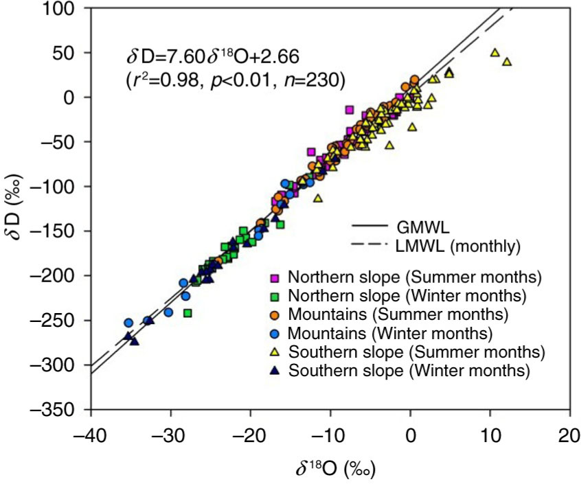
Fig. 5
Correlation between monthly weighted δD and δ 18O for each station around the Tianshan Mountains from August 2012 to September 2013
{ label needed for table-wrap[@id='UT0003'] }
Table 3. Slopes (S) and correlation coefficients (r) between δ 18O and meteorological parameters (T – air temperature, P – precipitation, RH – relative humidity and e – vapour pressure) during precipitation events for each station around the Tianshan Mountains from August 2012 to September 2013
StationS (‰/°C)rS (‰/mm)rS (‰/%)rS (‰/hPa)r
Yining (N1)0.78±0.040.90−0.96±0.20−0.45−0.40±0.08−0.461.30±0.090.85Jinghe (N2)0.64±0.080.78−0.22±0.18−0.19−0.28±0.08−0.510.94±0.150.70Kuytun (N3)0.66±0.060.84−0.17±0.42−0.06−0.42±0.09−0.561.22±0.130.81Shihezi (N4)0.76±0.040.89−0.48±0.28−0.20−0.51±0.08−0.581.42±0.110.83Caijiahu (N5)0.73±0.040.930.08±0.400.03−0.40±0.15−0.341.43±0.110.88Urumqi (N6)0.74±0.040.900.03±0.200.02−0.51±0.13−0.411.46±0.100.87Qitai (N7)0.73±0.050.900.27±0.250.16−0.35±0.21−0.251.45±0.120.88Wuqia (M1)0.73±0.100.69−0.14±0.15−0.12−0.17±0.05−0.401.59±0.300.55Akqi (M2)0.78±0.090.75−0.15±0.08−0.22−0.16±0.06−0.331.37±0.180.71Bayanbulak (M3)0.99±0.070.84−0.22±0.21−0.11−0.24±0.06−0.372.81±0.220.79Balguntay (M4)0.81±0.140.59−0.23±0.17−0.17−0.17±0.05−0.391.04±0.290.42Barkol (M5)0.78±0.070.850.39±0.290.19−0.41±0.11−0.461.81±0.200.79Yiwu (M6)0.74±0.130.77−0.02±0.32−0.01−0.24±0.14−0.361.50±0.330.70Aksu (S1)0.54±0.100.67−0.25±0.15−0.26−0.28±0.07−0.580.81±0.280.43Baicheng (S2)0.80±0.070.860.31±0.450.10−0.18±0.08−0.301.50±0.180.77Kuqa (S3)0.91±0.070.91−0.38±0.47−0.13−0.42±0.08−0.661.64±0.240.74Luntai (S4)0.68±0.250.50−0.32±0.23−0.28−0.10±0.09−0.221.19±0.500.44Korla (S5)0.93±0.070.950.71±1.040.15−0.52±0.13−0.662.12±0.260.87Kumux (S6)0.84±0.100.86−1.25±0.58−0.39−0.30±0.08−0.611.54±0.320.68Dabancheng (S7)0.86±0.120.910.43±0.930.140.17±0.330.161.58±0.370.80Turpan (S8)0.98±0.120.89−8.03±2.14−0.65−0.51±0.13−0.681.58±0.320.75Shisanjianfang (S9)0.55±0.070.975.75±3.540.63−0.01±0.35−0.011.16±0.190.95Hami (S10)1.14±0.090.95−3.12±2.05−0.36−1.04±0.29−0.662.24±0.300.88
{ label needed for table-wrap[@id='UT0004'] }
Table 4. Total precipitation amounts (P), slopes (S) and correlation coefficients (r) between air temperature and δ 18O for solid and liquid samples in selected stations with >10 solid samples around the Tianshan Mountains from August 2012 to September 2013
Psolid (mm)Ssolid (‰/°C)rnSsolid–Sall (‰/°C)Pliquid (mm)Sliquid (‰/°C)rnSliquid–Sall (‰/°C)
Yining (N1)126.30.29±0.190.3026−0.49179.70.84±0.080.79600.06Shihezi (N4)57.80.52±0.230.5017−0.23158.80.76±0.130.64530.00Caijiahu (N5)36.30.76±0.190.68200.03143.40.70±0.110.7236−0.03Urumqi (N6)103.40.84±0.160.67340.10246.70.84±0.130.73400.10Qitai (N7)43.10.60±0.260.5514−0.13202.10.74±0.140.70300.00Bayanbulak (M3)12.51.35±0.320.80120.36206.90.80±0.120.6078−0.19Barkol (M5)35.50.73±0.330.4621−0.05154.10.70±0.160.6529−0.07
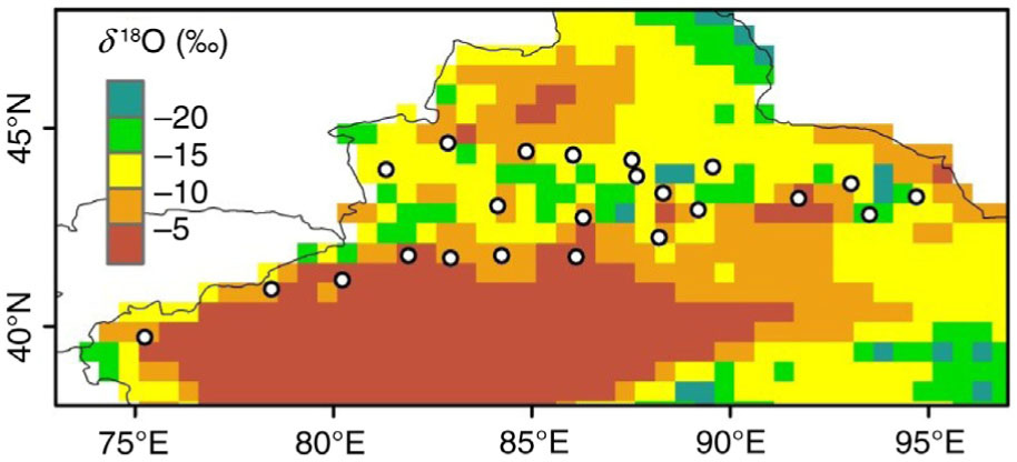
Fig. 6
Spatial distribution of predicted δ 18O in precipitation on an annual basis around the Tianshan Mountains from September 2012 to August 2013.
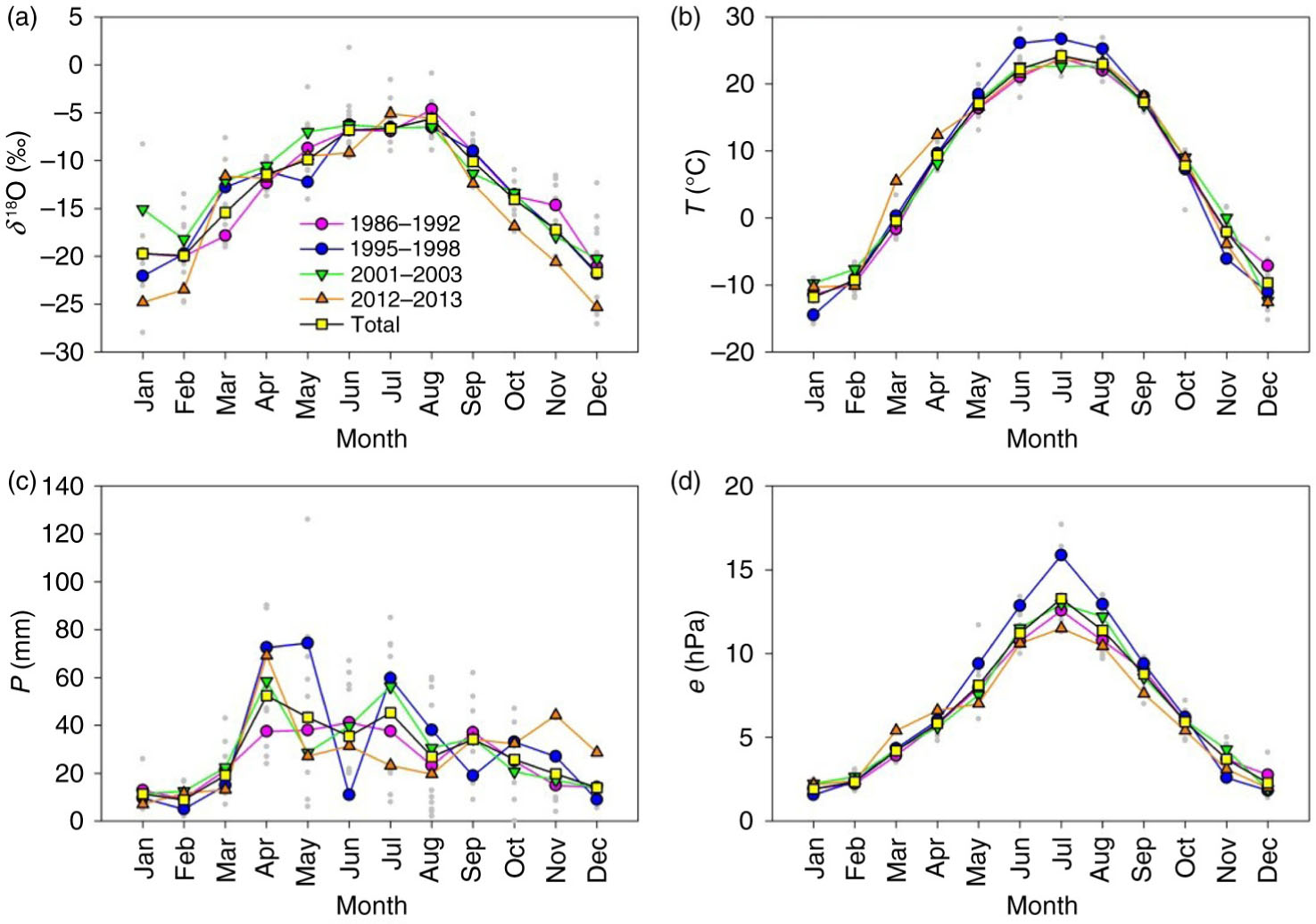
Fig. 7
Monthly variations of (a) δ 18O in precipitation, (b) air temperature, (c) precipitation amount and (d) vapour pressure in Urumqi during periods 1986–1992, 1995–1998, 2001–2003 and 2012–2013. Dots represent all monthly data points.
Table 5. Slope (S) and correlation coefficient (r) between monthly δ 18O and air temperature and sample number (n) in Urumqi during periods 1986–1992, 1995–1998, 2001–2003 and 2012–2013
S (‰/°C)0.44±0.030.37±0.040.35±0.040.51±0.040.41±0.02r0.860.890.820.960.86n72283113144