
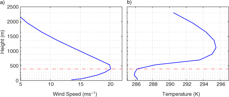
Fig. 1
Vertical profiles of (a) wind speed and (b) temperature for a CLLJ along California at 39°N–125°W using Era-Interim data. Red line indicates the level of wind maxima while grid lines represent vertical grid spacing corresponding to Era-Interim model vertical levels.
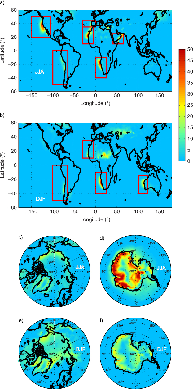
Fig. 2
Global maps of CLLJ frequency of occurrence (%) with regions of interest enclosed in red for (a) JJA global, (b) DJF global, (c) JJA north of 60°N, (d) JJA south of 60°S, (e) DJF north of 60°N, (f) DJF south of 60°S.
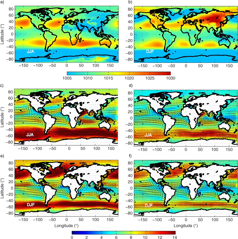
Fig. 3
Globally averaged ERA-Interim mean sea-level pressure (MSLP) for (a) JJA season (b) DJF season, and wind speed for (c and d) JJA at 400 m a.s.l. and at the lowest model level, (e and f) DJF at 400 m a.s.l. and at the lowest model level. The data are from the period 1980–2011.
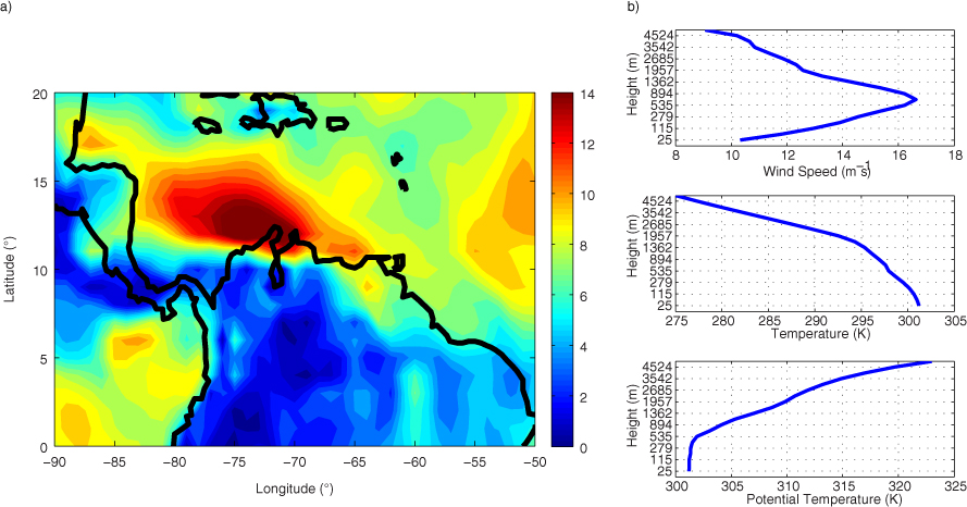
Fig. 4
(a) Mean wind speed at 400 m a.s.l. for a summer event (July 2006), and (b) vertical profiles of wind speed, temperature and potential temperature at 13°N–74°W. The vertical height scales in Fig. 4 and subsequent figures correspond to the Era-Interim model height levels.
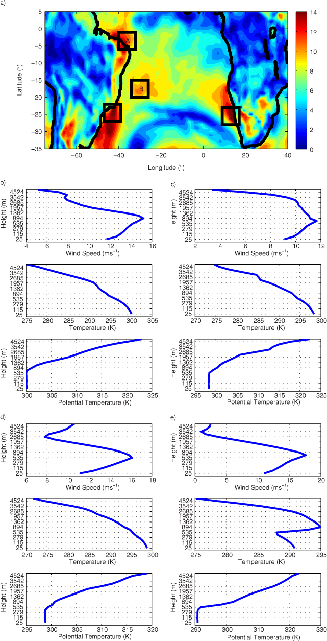
Fig. 5
(a) Wind speed at 400 m a.s.l. for a southern hemispheric summer event (5 January 2005), and vertical profiles of wind speed, temperature and potential temperature for (b) point-A (c) point-B (d) point-C and (e) point-D.
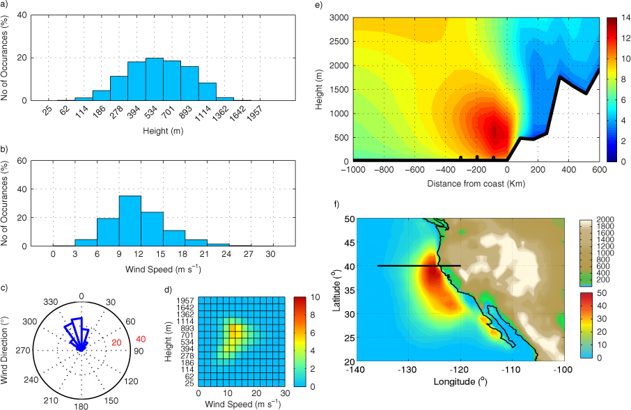
Fig. 6
CLLJ statistics for NACJ for JJA, (a) jet-height histogram (%), (b) jet wind-speed histogram (%), (c) jet wind direction (%), (d) jet height-wind histogram (%), (e) east-west cross-section at 40°N (wind speed in m s−1), with black dots for λ R and (f) frequency of occurrence (%), with topography (metres). Black line marks the cross-section.
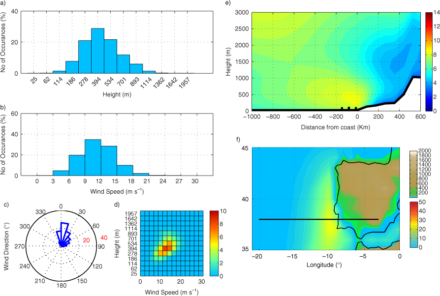
Fig. 7
CLLJ statistics for IPCJ for JJA, (a) jet-height histogram (%), (b) jet wind-speed histogram (%), (c) jet wind direction (%), (d) jet height-wind histogram (%), (e) east-west cross-section at 38°N (wind speed in m s−1), with black dots for λ R and (f) frequency of occurrence (%), with topography (metres). Black line marks the cross-section.
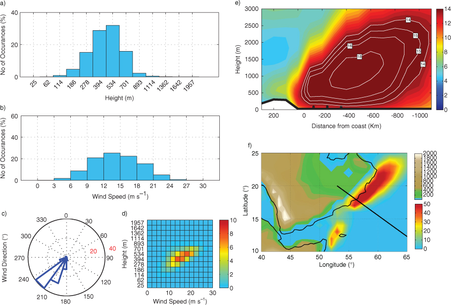
Fig. 8
CLLJ statistics for APCJ for JJA, (a) jet-height histogram (%), (b) jet wind-speed histogram (%), (c) jet wind direction (%), (d) jet height-wind histogram (%), (e) cross-section perpendicular to the direction of wind (wind speed in m s−1), with black dots for λ R and (f) frequency of occurrence (%), with topography (metres). Black line marks the cross-section.
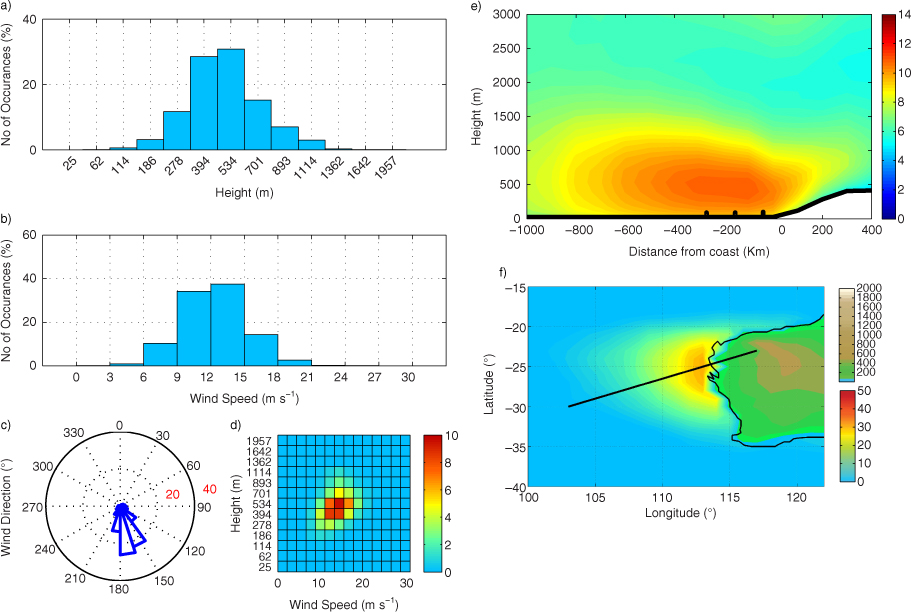
Fig. 9
CLLJ statistics for AUCJ for DJF, (a) jet-height histogram (%), (b) jet wind-speed histogram (%), (c) jet wind direction (%), (d) jet-height-wind histogram (%), (e) cross-section perpendicular to the wind direction (wind speed in m s−1), with black dots for λ R and (f) frequency of occurrence (%), with topography (metres). Black line marks the cross-section.
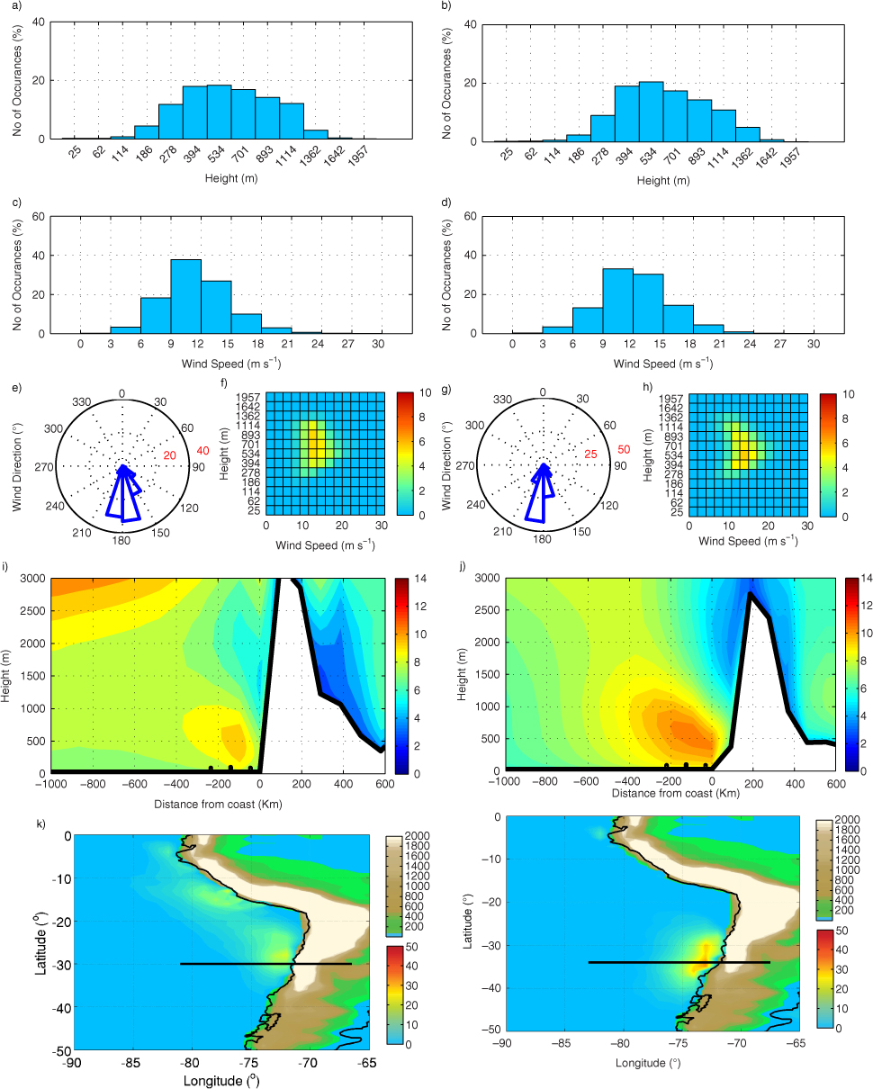
Fig. 10
CLLJ statistics for JJA (left) and DJF (right) for the SACJ, (a and b) jet-height histogram (%), (c and d) jet wind-speed histogram (%), (e and g) jet wind direction (%), (f and h) jet height-wind histogram (%), (i and j) east-west cross-section at 30°S and 34°S (wind speed in m s−1), with black dots for λ R and (k and l) frequency of occurrence (%) with topography (metres). Black line marks the cross-section.
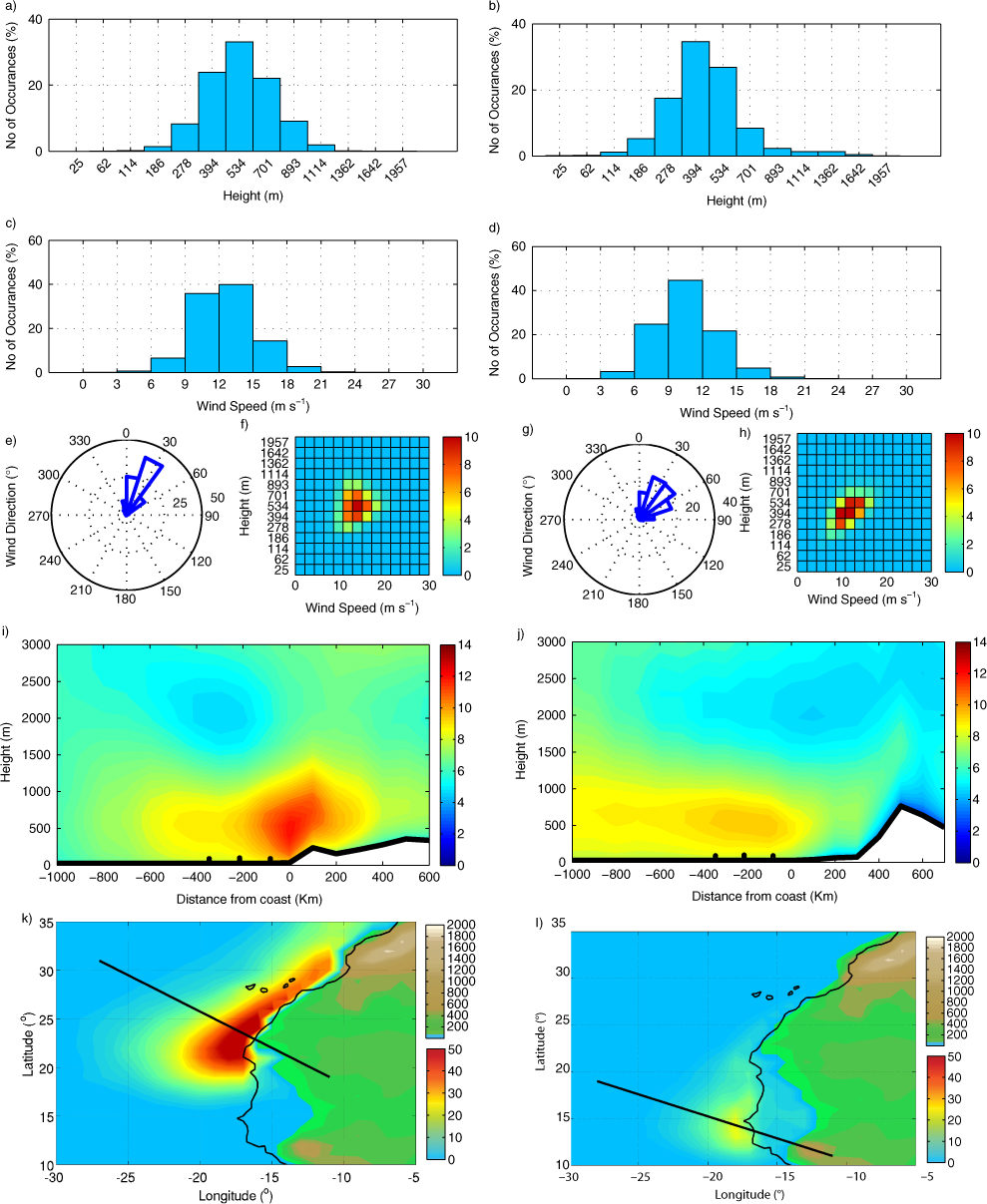
Fig. 11
CLLJ statistics for JJA (left) and DJF (right) for the NAFCJ, (a and b) jet-height histogram (%), (c and d) jet wind-speed histogram (%), (e and g) jet wind direction (%), (f and h) jet height-wind histogram (%), (i and j) cross-section perpendicular to wind direction (wind speed in m s−1), with black dots for λ R and (k and l) frequency of occurrence (%) with topography (metres). Black line marks the cross-section.
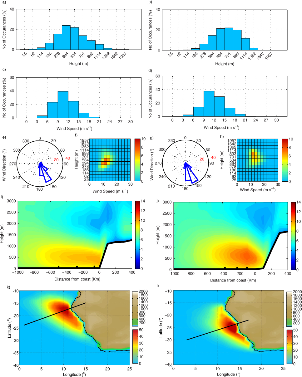
Fig. 12
CLLJ statistics for JJA (left) and DJF (right) for SAFCJ, (a and b) jet-height histogram (%), (c and d) jet wind-speed histogram (%), (e and g) jet wind direction (%), (f and h) jet height-wind histogram (%), (i and j) cross-section perpendicular to the wind direction (wind speed in m s−1) with black dots for λ R, (k and l) frequency of occurrence (%) with topography (metres), black line marks the cross-section.
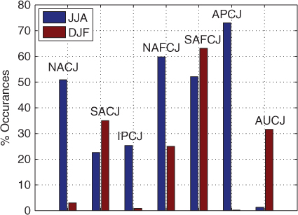
Fig. 13
Seasonal percentage CLLJ occurrences (maximum) for each region.
Table 1. Summary of the regional CLLJ characteristics
RegionFrequency of occurrence (%)Mean wind speed (m s−1)Mean jet height (m)Frequency of occurrence (%)Mean wind speed (m s−1)Mean jet height (m)
NACJ5011.67053––IPCJ2511.34681––APCJ7214.24850.2––AUCJ1––3112.5555SACJ2211.77223512.5704NAFCJ5912.65622510.2467SAFCJ5210.95496312.0634