
Figure 1
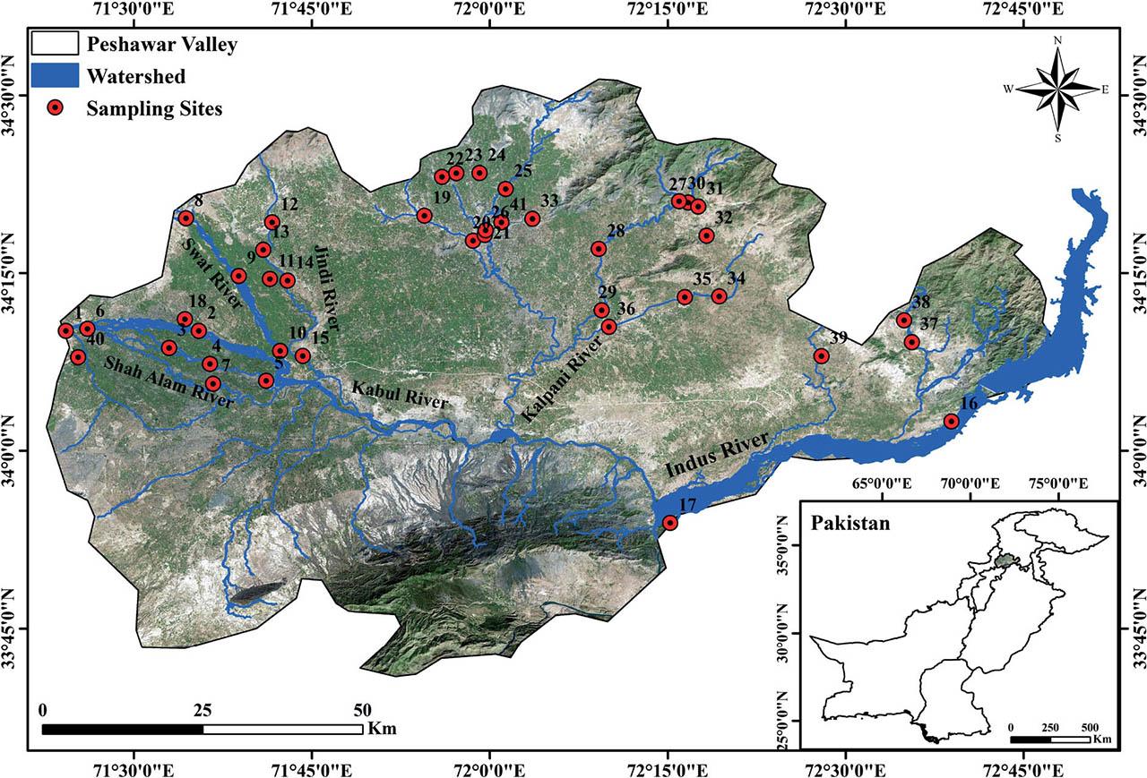
Figure 2

Figure 3

Figure 4
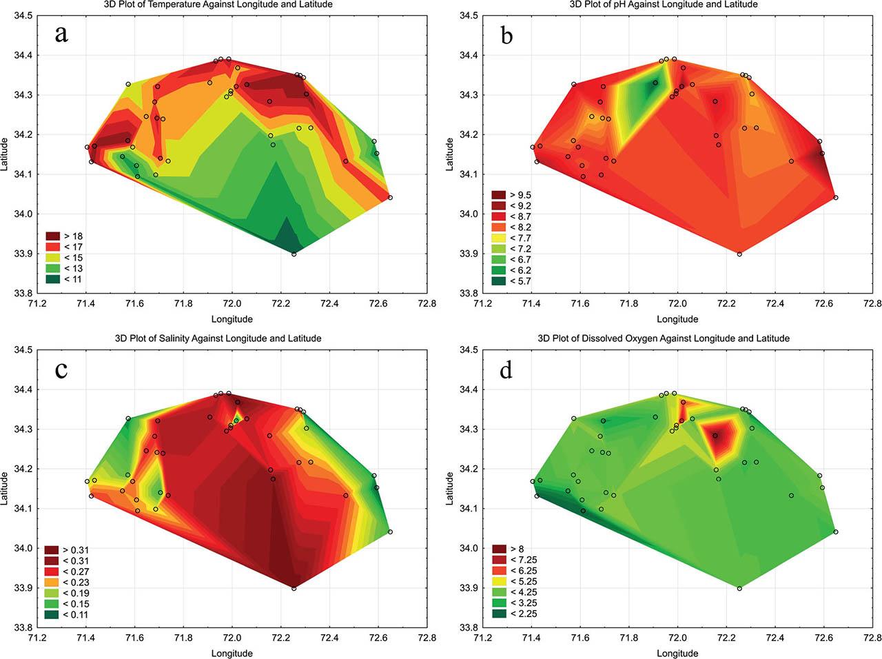
Figure 5

Figure 6

Figure 7
Figure 8

Charophyta species and water quality parameters in the Peshawar Valley
| Site Code | Chara braunii | Chara connivens | Chara contraria | Chara globularis | Chara vulgaris | Nitellopsis obtusa | Temp. °C | pH | ORP mV | EC, μS cm−1 | Resis. Ω-cm | TDS ppm | Sal. PSU | DO mg l−1 |
|---|---|---|---|---|---|---|---|---|---|---|---|---|---|---|
| KRW | − | − | − | − | + | − | 15.84 | 8.19 | 67.4 | 435 | 1786 | 197 | 0.19 | 3.34 |
| KRHZ | − | − | − | − | + | − | 14.9 | 8.36 | 88.6 | 468 | 2158 | 240 | 0.24 | 4.16 |
| NRN | − | − | − | − | + | − | 11.58 | 8.34 | 147.3 | 471 | 2123 | 236 | 0.23 | 3.12 |
| NRNA | − | − | − | − | + | − | 11.94 | 8.25 | 28 | 468 | 2137 | 234 | 0.23 | 3.82 |
| NRJ | − | − | − | + | − | − | 14.07 | 8.41 | 86.3 | 438 | 2283 | 219 | 0.21 | 4.42 |
| SARM | − | − | − | + | − | − | 18.61 | 8.28 | 101.3 | 437 | 2288 | 218 | 0.21 | 3.48 |
| SARSA | − | − | − | + | + | − | 11.66 | 8.39 | −50.8 | 474 | 2110 | 237 | 0.23 | 2.27 |
| SRM | − | − | − | + | − | − | 13.9 | 8.66 | 94.9 | 243 | 4115 | 122 | 0.12 | 4.34 |
| SRDG | − | − | − | − | + | − | 15.28 | 7.78 | 24.6 | 525 | 1905 | 262 | 0.26 | 3.91 |
| SRC | − | + | − | − | − | − | 16.44 | 8.39 | 74.5 | 308 | 3247 | 154 | 0.15 | 4.01 |
| ARC | − | − | − | + | − | − | 17.44 | 7.87 | 63.1 | 469 | 2132 | 234 | 0.23 | 3.83 |
| JRTHR | − | − | + | − | + | − | 16.42 | 8.49 | 68.2 | 582 | 1718 | 291 | 0.28 | 2.93 |
| JRK | − | − | − | + | + | − | 16.09 | 8.53 | 99.1 | 531 | 1883 | 265 | 0.26 | 4.39 |
| JRU | − | − | − | − | + | − | 15.24 | 8.07 | 67 | 565 | 1770 | 283 | 0.28 | 4.15 |
| JRPM | − | − | + | − | − | − | 14.74 | 8.2 | 82.4 | 549 | 1821 | 274 | 0.27 | 4.29 |
| IRG | − | − | + | − | + | + | 16.54 | 8.36 | 131.4 | 311 | 3215 | 156 | 0.15 | 3.44 |
| IRAK | − | − | − | − | + | − | 10.32 | 8.25 | 120.1 | 643 | 1555 | 321 | 0.32 | 3.84 |
| SKSU | − | − | − | − | + | − | 18.8 | 8.03 | 99.3 | 430 | 1753 | 176 | 0.17 | 4.02 |
| JSJ | − | − | − | − | + | − | 15.71 | 5.63 | 236.2 | 586 | 2152 | 297 | 0.29 | 3.34 |
| JSMKK | − | − | − | − | + | − | 14.79 | 8.34 | 63.3 | 554 | 1805 | 277 | 0.27 | 4.79 |
| UKSUA | − | − | − | − | + | − | 15.03 | 8.3 | 78.8 | 532 | 1880 | 266 | 0.26 | 4.66 |
| BKSH | − | − | − | − | + | − | 18.19 | 8.15 | 106.5 | 547 | 1828 | 274 | 0.27 | 4.59 |
| GKSSD | − | − | − | − | + | − | 16.93 | 7.8 | 124.5 | 581 | 1721 | 291 | 0.28 | 4.52 |
| LKSLK | − | − | − | − | + | − | 17.89 | 8.18 | 105.8 | 258 | 2175 | 315 | 0.31 | 4.46 |
| SDSSD | − | − | − | − | + | − | 15.25 | 8.45 | 101.2 | 296 | 2256 | 326 | 0.32 | 6.2 |
| SDSSA | − | − | − | − | + | − | 14.86 | 8.38 | 76.4 | 477 | 2096 | 239 | 0.23 | 5.09 |
| BSH | − | − | − | − | + | − | 19.37 | 7.71 | 85.7 | 557 | 1795 | 278 | 0.27 | 3.98 |
| BSB | − | − | − | + | + | − | 17.53 | 8.77 | 75 | 506 | 1976 | 253 | 0.25 | 8.09 |
| BSGK | − | − | − | − | + | − | 14.49 | 8.37 | 70.2 | 552 | 1812 | 276 | 0.27 | 4.59 |
| PTSC | − | − | − | − | + | − | 18.5 | 7.92 | 60.9 | 487 | 2053 | 244 | 0.24 | 3.82 |
| DSHW | − | − | − | − | + | − | 15.28 | 8.24 | 16.5 | 238 | 4202 | 119 | 0.11 | 2.66 |
| MSM | − | − | − | − | + | − | 18.53 | 7.85 | 78.7 | 402 | 2488 | 201 | 0.19 | 3.82 |
| GSKR | − | − | − | − | + | − | 18.22 | 8.12 | 87.7 | 579 | 1727 | 289 | 0.28 | 4.11 |
| NST | − | − | − | − | + | − | 14.66 | 8 | 71.5 | 468 | 2137 | 234 | 0.23 | 3.52 |
| NSA | − | − | + | − | + | − | 14.38 | 8.02 | 87.4 | 501 | 1996 | 250 | 0.24 | 3.46 |
| NSSCR | − | − | − | − | + | − | 12.28 | 8.35 | 71.1 | 639 | 1565 | 320 | 0.31 | 3.75 |
| BSP | − | − | + | + | + | − | 10.86 | 9.58 | 65.6 | 203 | 4926 | 102 | 0.1 | 4.34 |
| PSP | + | − | − | − | + | − | 11.99 | 8.84 | 63.5 | 269 | 3717 | 135 | 0.13 | 4.19 |
| BSMK | − | − | + | − | − | − | 16.33 | 8.1 | 54.2 | 509 | 1965 | 255 | 0.25 | 3.58 |
| WWP | − | − | − | + | + | − | 18.86 | 8.92 | 28.5 | 513 | 1949 | 256 | 0.25 | 2.22 |
| JGWM | − | − | − | − | + | − | 16.62 | 9.28 | 74.9 | 257 | 3891 | 128 | 0.12 | 7.02 |
Study sites in the Peshawar Valley with geographic locations
| No. | Site Name | Site Code | Latitude | Longitude |
|---|---|---|---|---|
| 1 | Kabul River–Warsak | KRW | 34°10′6.96″ | 71°24′15.84″ |
| 2 | Kabul River–Haji Zai | KRHZ | 34°10′6.96″ | 71°35′28.32″ |
| 3 | Naguman River–Niyami | NRN | 34°8′40.92″ | 71°32′58.56″ |
| 4 | Naguman River–Naguman | NRNA | 34°7′19.56″ | 71°36′25.2″ |
| 5 | Naguman River–Jalabella | NRJ | 34°5′54.6″ | 71°41′9.6″ |
| 6 | Shah Alam River–Michni | SARM | 34°10″17.04″ | 71°26′4.56″ |
| 7 | Shah Alam River–Shah Alam | SARSA | 34°5′39.48″ | 71°36′41.04″ |
| 8 | Swat River–Munda | SRM | 34°19′37.2″ | 71°34′23.88″ |
| 9 | Swat River–Dildar Gharhi | SRDG | 34°14′44.52″ | 71°38′50.28″ |
| 10 | Swat River–Charsadda | SRC | 34°8′25.44″ | 71°42′19.8″ |
| 11 | Abazai River–Cheena | ARC | 34°14′30.12″ | 71°41′27.96″ |
| 12 | Jindi River–Tangi Harichand Road | JRTHR | 34°19′15.96″ | 71°41′39.48″ |
| 13 | Jindi River–Kanewar | JRK | 34°16′57″ | 71°40′54.48″ |
| 14 | Jindi River–Umarzai | JRU | 34°14′21.84″ | 71°42′57.6″ |
| 15 | Jindi River–Prang Majoke | JRPM | 34°8′0.24″ | 71°44′14.64″ |
| 16 | Indus River–Galla | IRG | 34°2′29.04″ | 72°38′55.68″ |
| 17 | Indus River–Attock Khurd | IRAK | 33°53′55.32″ | 72°15′12.6″ |
| 18 | Subhan Khwar Stream–Uchawala | SKSU | 34°11′6″ | 71°34′17.76″ |
| 19 | Jalala Stream–Jalala | JSJ | 34°19′50.52″ | 71°54′29.52″ |
| 20 | Jalala Stream–Mahabat Khan Koroona | JSMKK | 34°17′43.44″ | 71°58′35.4″ |
| 21 | Uch Khwar Stream–Umar Abad | UKSUA | 34°18′12.24″ | 71°59′34.8″ |
| 22 | Bama Kandah Stream–Hathian | BKSH | 34°23′6.72″ | 71°55′59.16″ |
| 23 | Ghargo Kandah Stream–Spalano Dheri | GKSSD | 34°23″25.44″ | 71°57′10.8″ |
| 24 | Lund Khwar Stream–Lund Khwar | LKSLK | 34°23′26.16″ | 71°59′8.52″ |
| 25 | Shamsi Dan Stream–Shamsi Dan | SDSSD | 34°22′5.52″ | 72°1′21″ |
| 26 | Shamsi Dan Stream–Said Abad | SDSSA | 34°18′36″ | 71°59′39.84″ |
| 27 | Balar Stream–Hamzakot | BSH | 34°20′56.4″ | 72°16′43.68″ |
| 28 | Balar Stream–Bakhshali | BSB | 34°17′1.68″ | 72°9′11.16″ |
| 29 | Balar Stream–Gari Kapura | BSGK | 34°11′51.36″ | 72°9′26.64″ |
| 30 | Pacha Tangi Stream–Cheena | PTSC | 34°21′3.6″ | 72°15′58.32″ |
| 31 | Dagi Stream–Hera Wand | DSHW | 34°20′36.6″ | 72°17′34.44″ |
| 32 | Machi Stream–Machi | MSM | 34°18′9″ | 72°18′16.92″ |
| 33 | Gadar Stream–Katlang Road | GSKR | 34°19′33.96″ | 72°3′35.64″ |
| 34 | Naranji Stream–Turlandi | NST | 34°13′1.56″ | 72°19′20.64″ |
| 35 | Naranji Stream–Adina | NSA | 34°12′57.96″ | 72°16′26.76″ |
| 36 | Naranji Stream–Sim Canal Road | NSSCR | 34°10′27.48″ | 72°10′3.36″ |
| 37 | Bada Stream–Pabaini | BSP | 34°9′10.08″ | 72°35′35.52″ |
| 38 | Panjman Stream–Panjman | PSP | 34°11′0.24″ | 72°34′56.64″ |
| 39 | Badri Stream–Mami Khel | BSMK | 34°7′58.8″ | 72°27′58.68″ |
| 40 | Warsak Wetland–Peshawar | WWP | 34°7′53.76″ | 71°25′18.12″ |
| 41 | Jamal Gharhi Wetland–Mardan | JGWM | 34°19′16.32″ | 72°0′59.4″ |