
Introduction
Radiation in the environment can originate from cosmic rays, terrestrial radiation, and anthropogenic sources [1]. Cosmic radiation arises from outer space as primary cosmic rays, while terrestrial radiation is derived from radionuclides present in the soil, rocks, building materials, food, and water [2, 3]. Natural radionuclides consist primarily of 40K and the decay products of the 238U and 232Th series, which have been present in the environment since the formation of the universe [4]. The distribution and concentration of radionuclides in soil vary both spatially and temporally, depending on geological and geographical factors, climatic conditions, and human activities such as mining, milling, agriculture, atmospheric emissions, and industrial solid and liquid waste [1, 5,6,7]. Multiple studies have been conducted to evaluate the levels of natural and artificial radioactivity in Algerian soils using gamma spectrometry. A study revealed the presence of both natural radionuclides and artificial 137Cs at varying concentrations and concluded that Algeria was indeed affected by the Chernobyl accident [8]. Similarly, an examination of unfertilized soil samples from the Setif and El Athmania agricultural regions showed values within global averages; however, the use of fertilizers, particularly the mono ammonium phosphate and the prolonged use of farmyard manure fertilizer, induced a significant elevation in 40K concentration, suggesting potential health risks for farmers and consumers [9, 10]. Furthermore, potential health hazards associated with phosphate ores from eastern Algeria (Ouanzae-Tebessa and Bordj Ghdire-Setif) were reported in another study due to the high activity concentrations of 238U and 232Th [11]. In another study, gamma-ray spectrometry measurements of 238U, 232Th, and 40K in natural spring and groundwater from three areas in Bordj Bou Arreridj (Chenia well, Zemala spring, and Ksir El Ghoul spring) showed that most samples had activity concentrations below the recommended safety limits. However, the Zemala spring exhibited relatively high concentrations of 238U, likely due to the interaction between the spring water and the underlying bedrock in the area, rendering it unsuitable for drinking [12]. Construction materials in the region were also evaluated for naturally occurring radionuclides from the uranium and thorium series, as well as 40K. Most materials showed activity concentrations within global reference levels, although elevated 40K was detected in ceramics and certain bricks. Radiological indices remained below international limits, indicating no significant hazard, though ceramics exhibited comparatively higher activity. Low levels of 137Cs were also detected in three sand samples [13]. Despite these contributions, most research has focused on fertilizers, agricultural soils, groundwater, building materials, and phosphate ores, whereas research on soil radioactivity in Algeria's intensive industrial areas remains scarce. To date, no field-based assessments are available to measure the accumulation of radionuclides, whether natural or artificial, in major industrial regions such as M'sila and Bordj Bou Arreridj. These regions comprise ceramic and cement plants, metal processing facilities, raw material storage sites, and other establishments with potential technologically enhanced natural radiation (TENORM) emissions. This deficiency in available data constitutes a critical knowledge gap, significantly impeding the precise evaluation of environmental radiological risks and associated public health hazards. The primary objective of this study is to establish a comprehensive radiological baseline and determine the activity concentrations of natural radionuclides in soil samples collected from the industrial zones of Bordj Bou Arreridj and M'sila, eastern Algeria. Using high-resolution gamma-ray spectrometry with a HPGe detector, this work employs a composite sampling strategy to ensure representative environmental mapping. Several parameters related to radiological risk, such as specific activity, internal and external hazard indices, radium equivalent activity, excess lifetime cancer risk, and annual effective dose, were evaluated to estimate the radiological impact of natural radioactivity in the samples. The investigation of their distribution in soil samples provides essential data for environmental radiation monitoring and the development of local safety standards. The radiological measurements were performed at the laboratory of the Nuclear Research Centre of Birine (NRCB), Algeria, in collaboration with the Laboratory of Materials Physics, Radiation and Nanostructures (LMPRN).
Study area
The regions of Bordj Bou Arreridj and M'sila are strategically located within the High Plateaus of eastern Algeria and exhibit diverse geographical, climatic, agricultural, and industrial characteristics. In Bordj Bou Arreridj, the topography varies between mountainous heights in the north, such as the Biban chain, wide plains in the central part including the Medjana plain, and plateaus extending southwards towards the steppe areas. The region experiences a semi-arid continental climate characterized by hot, dry summers and cold winters, contributing to a pedological diversity that includes steppe soils, clayey agricultural soils, and calcareous (limestone-dominated) soils. Bordj Bou Arreridj is recognized as a major industrial and agricultural hub; it hosts sectors such as construction materials, processing industries, and electronics production, in addition to intensive limestone quarries and clay extraction mines. Similarly, the region of M'sila is defined by a rugged continental climate with hot summers and cold winters. It displays a diverse topographical profile that includes mountainous areas such as Mount El-Hodna and Mount El Gergueur, high plateaus, steppe regions, and semi-arid zones. Its soils are complex and varied, including alluvial, calcareous, steppe, sandy, and saline (sabkha-related) types. M'sila is also a critical center for building materials production, with factories producing cement, bricks, tiles, iron, and aluminum, as well as numerous open-pit quarries and stone mines. Agriculturally, the region supports diverse crop and livestock production, with widespread cultivation of grains and various fruit trees. Additionally, M'sila is working on establishing food-processing units and promoting the production of organic fertilizers. The coexistence of diverse geological formations and extensive industrial activities in the study area necessitates a rigorous radiological assessment to establish a baseline for environmental safety and public health protection. Accordingly, soil samples were collected from industrial zones located in Bordj Bou Arreridj and M'sila in eastern Algeria, as illustrated in Fig. 1.
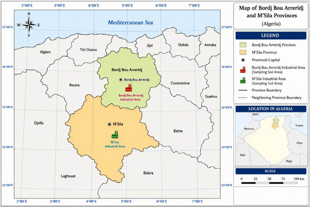
Fig. 1.
Location map of Bordj Bou Arreridj and M'sila provinces in Algeria showing the industrial sampling areas [14].
Materials and measurement methods
Preparation of samples
In this study, a total of two composite samples were collected from industrial zones located in Bordj Bou Arreridj and M'sila, in the eastern region of Algeria. The sampling locations are shown in Fig. 1. To ensure a high degree of spatial representation and to minimize local variability within these industrial areas, a composite sampling strategy was implemented. Each composite sample was taken from a representative area of approximately 100 × 100 m2 using the diagonal sampling method. Five to ten sub-samples were collected at an approximate depth of 5 cm, including one from each of the four corners and one from the center of the sampling grids. These sub-samples were thoroughly mixed to obtain a single homogenized composite sample after removing plant roots, stones, and other extraneous materials. This approach provides a more reliable assessment of the average radioactivity levels compared to individual point samples. The resulting composite sample was then dried in an oven, ground into a fine powder, and sieved. Finally, it was placed in a labeled airtight container with essential metadata (collection site, date, weight, etc.) before being sent to the laboratory of the Nuclear Research Centre of Birine (CRNB), Algeria, for high-precision gamma spectrometry analysis [15].
Materials and calibration of the measurement chain
The experimental measurements were carried out using a gamma spectrometry system equipped with a p-type coaxial HPGe detector (model GC3018, Canberra Industries). The relative efficiency of the detector is specified as 36%. The energy resolution (FWHM) and the peak-to-Compton ratio (P/C) for the 1.335 MeV gamma line of 60Co were found to be 1.98 keV and 69.6:1, respectively. These values are in good agreement with the manufacturer's specifications (1.8 keV and 70.6:1) for the same energy. The detector was housed in a 10 cm thick lead shield (model 650N) and further protected from X-rays generated in the lead by two additional layers: 1 mm of tin and 1.6 mm of copper. The HPGe detector was coupled to a preamplifier (model 2012C) and a digital signal analyzer (Lynx Digital Signal Analyzer, LDSP) with a shaping time of 4 μs. The coarse and fine gains were set to 4 and 0.96420×, respectively. A recommended high voltage of 4000 V was applied to the detector. Spectrum acquisition and radionuclide identification were performed using the Genie 2000 analysis software. Energy and efficiency calibrations were performed prior to sample analysis to ensure accurate radionuclide identification and quantitative determination. Energy calibration was conducted using a certified 152Eu standard source, employing its well-defined gamma-ray emission lines to establish the relationship between channel numbers and gamma-ray energies over the energy range up to approximately 2000 keV. This procedure ensured reliable energy assignment for all measured spectra under identical acquisition conditions. The absolute full-energy peak efficiency calibration was experimentally established using certified multi-nuclide reference sources 133Ba and 152Eu supplied by LEA-CERCA (France). The radionuclides were uniformly distributed in a gel matrix and contained in 1-L Marinelli beaker geometry. This geometry was specifically selected to replicate the same counting configuration, density, and sample volume of the investigated soil samples, thereby minimizing systematic uncertainties associated with geometry mismatch and gamma-ray self-attenuation. For each calibration energy, the net peak areas were determined after background subtraction and used to calculate the absolute full-energy peak efficiency according to the known source activity, gamma emission probabilities, and counting time. The efficiency values were derived across a wide energy range using the principal gamma-ray emissions of 133Ba (81.0, 276.4, 302.9, 356.0, and 383.8 keV) and 152Eu (121.8, 244.7, 344.3, 778.9, 964.1, 1112.1, 1408.0, and 1457.6 keV). These experimentally determined efficiency points were then fitted using a sixth-order logarithmic polynomial function employing the APOLOG algorithm implemented in Genie 2000 software. As illustrated in Fig. 2, the detector efficiency exhibits a smooth energy-dependent behavior described by a sixth-order logarithmic polynomial fit, providing a continuous efficiency model over the full energy range required for gamma-ray spectrometric analysis. To account for environmental and detector-related background radiation, a background spectrum was acquired using an empty Marinelli beaker under identical shielding and experimental conditions as those used for the samples. The background measurement was performed for 50 h (180 000 s) to ensure high statistical accuracy. Each soil sample was measured for a total counting time of 48 h (172 800 s). The background spectrum was subtracted from each gross sample spectrum prior to peak analysis to obtain net peak areas. This procedure is essential to eliminate contributions from ambient radiation and detector background, thereby preventing systematic overestimation of radionuclide activity concentrations, particularly for low-activity samples.
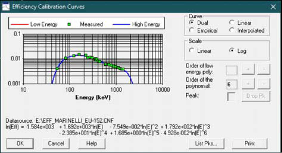
Fig. 2.
The efficiency calibration curve of the gamma spectrometry system.
Uncertainty analysis
The experimental uncertainties associated with the activity concentrations of the directly measured radionuclides (40K and 137Cs) and those derived from the 226Ra and 232Th decay series are initially expressed as percentages. These experimental uncertainties were calculated by propagating the individual sources of error using the standard error propagation law, taking into account the counting statistics of the net peak areas (obtained from Genie 2000 software), detector efficiency calibration, and sample geometry. The total standard uncertainty (±1σ) was calculated according to the following mathematical formula:
where σN, σɛ, σm, and σP represent the uncertainties in the net peak area, detector efficiency, sample mass, and gamma-ray emission probability, respectively. All reported error percentages in the tables correspond to a standard confidence level of 68% (±1σ). To comply with international metrological standards, these standard values were subsequently converted into the expanded uncertainty (U) by applying a coverage factor of k = 2 to ensure a 95% confidence level [16, 17]:The estimated expanded uncertainties remained within acceptable limits, demonstrating the high precision and reproducibility of the HPGe gamma-ray spectrometry measurements. Their contribution to the overall uncertainty budget was limited, thereby ensuring the reliability of the calculated activity concentrations and the associated radiological parameters.
Radioactivity measurement
A total of two composite samples were analyzed for natural radioactivity using high-resolution gamma-ray spectrometry with an HPGe detector. Prior to measurement, the samples were dried, homogenized, sieved, and sealed in airtight containers. The activity concentration of 226Ra was determined indirectly through the measurement of gamma emissions from its short-lived progeny, assuming secular equilibrium within the 226Ra decay series. To ensure equilibrium, the sealed samples were stored for at least four weeks prior to analysis, allowing the in-growth of 214Pb and 214Bi via 222Rn decay. The activity concentration of 226Ra was calculated as the weighted mean of values obtained from the gamma-ray lines at 351.9 keV of 214Pb, and 609.3 keV of 214Bi. Similarly, the activity concentration of 232Th was determined from its daughter radionuclides, typically using the gamma-ray lines of 228Ac (911.2 keV), 212Pb (238.6 keV), and 208Tl (583.2 keV), depending on the analysis protocol. The final 232Th activity concentration was calculated as the weighted average of the activities obtained from the selected daughter-product gamma lines, after confirming radioactive equilibrium within the 232Th decay series. Finally, the activity concentrations of 40K and 137Cs were directly determined from their characteristic gamma-ray emissions at 1460.8 keV and 661.66 keV, respectively.
The activity concentration As (Bq·kg−1) was calculated according to:
where: N – net area of the peak; ɛ – detector efficiency corresponding to the specific gamma-ray energy line Eγ; p – branching ratio; t – counting time (s); m – mass of the sample (kg).Gamma dose rate
The absorbed gamma dose rate in air was determined from the measured activity concentrations of radionuclides in the soil samples. For a uniform distribution of the natural radionuclides 226Ra, 232Th, and 40K, the absorbed gamma dose rate at 1 m above the ground surface was calculated using the following formula [18]:
where ARa, ATh, and AK represent the activity concentrations of 226Ra, 232Th, and 40K in the samples (Bq·kg−1), respectively. The coefficients 0.462, 0.604, and 0.0417 are the absorbed dose conversion factors (in nGy·h−1 per Bq·kg–1) for 226Ra, 232Th, and 40K, respectively, as reported in [19].Because the study area is contaminated by 137Cs, the activity of this isotope was considered in the calculations, and the dose was calculated accordingly [20]:
Annual effective dose
To estimate the outdoor annual effective dose, the conversion coefficient from absorbed dose in air to effective dose and the outdoor occupancy factor were taken into account. A dose conversion coefficient (DCF) of 0.7 Sv·Gy−1 and an outdoor occupancy factor (OF) of 0.2 were adopted in the present analysis. The outdoor annual effective dose was calculated using the following relationship [19]:
where AEDout is the outdoor annual effective dose (mSv·y−1), D is the absorbed dose rate in air (nGy·h−1), DCF is the dose conversion factor (0.7 Sv·Gy−1), OF is the outdoor occupancy factor (0.2), and T is the exposure time (8760 h·y–1). The factor 10−6 is the unit conversion factor accounting for the conversion from nGy to Gy and from Sv to mSv.Radium equivalent activity
The radium equivalent activity (Raeq) is an index used to estimate the potential radiological hazard and to predict the radiation exposure to the human body from the perspective of total radiation dose. It provides a single quantity that represents the combined activity concentrations of 226Ra, 232Th, and 40K considering their different gamma-ray dose contributions [21]. The expression for the radium equivalent activity was first proposed in [22]:
where ARa, ATh and AK are the activities of 226Ra, 232Th and 40K in Bq·kg−1, respectively.External hazard index
The external hazard index (Hex) is used to estimate the external radiation exposure due to gamma radiation [23]. The external hazard index (Hex) is defined as:
where ARa, ATh, and AK are the specific activities of 226Ra, 232Th, and 40K in Bq·kg−1, respectively.The external hazard index value must not exceed unity to ensure that the radiation hazard remains insignificant. The maximum value of Hex equal to unity which corresponds to the upper limit of radium equivalent activity of 370 Bq·kg−1 [22, 24].
Internal hazard index
The internal hazard index is used to assess the internal gamma-ray exposure [25]. This parameter is calculated using Eq. (9):
where ARa, ATh, and AK are the specific activities of 226Ra, 232Th, and 40K in Bq·kg−1, respectively. The internal hazard index must be less than unity for the radiation hazard to be considered negligible.Excess lifetime cancer risk
The excess lifetime cancer risk (ELCR) was calculated to estimate the cancer risk associated with continuous exposure to environmental radiation. The outdoor ELCR was assessed using Eq. (10):
where AEDout is the outdoor annual effective dose (Sv·y−1), DL is the average lifetime duration, taken as 70 years, and RF is the risk factor for stochastic effects, taken as 0.05 Sv−1 for the public [5, 26, 27].Results and discussion
The radiological assessment data obtained from the analyzed soil samples are presented in Tables 1 and 2. Table 1 summarizes the activity concentrations of natural radionuclides, absorbed dose rate, and annual effective dose. The evaluated radiological hazard parameters, including radium equivalent activity, external and internal hazard indices, and outdoor excess lifetime cancer risk are presented in Table 2. These results provide an overall assessment of the radiological status of the investigated area.
Table 1.
Activity concentrations of natural radionuclides, absorbed dose rate, and annual effective dose
| 226Ra | 232Th | 40K | 137Cs | |||
|---|---|---|---|---|---|---|
| Industrial zone Bordj Bou Arreridj | 12.5 ± 1.2 | 11.4 ± 0.3 | 136.5 ± 3.3 | 0.69 ± 0.06 | 18.7 ± 0.9 | 0.02 |
| Industrial zone M'sila | 28.7 ± 1.6 | 43.3 ± 1.0 | 792 ± 15 | – | 72.4 ± 2.0 | 0.09 |
| Mean | 20.6 ± 1.4 | 27.3 ± 0.7 | 464 ± 9 | – | 45.6 ± 1.4 | 0.06 |
Table 2.
Radium equivalent activity, external, internal hazard indices, and outdoor excess lifetime cancer risk
| Location | Raeq (Bq·kg−1) | Hex | Hint | ELCR |
|---|---|---|---|---|
| Industrial zone Bordj Bou Arreridj | 39.23 | 0.11 | 0.14 | 7 × 10⁻⁵ |
| Industrial zone M'sila | 151.58 | 0.41 | 0.49 | 3.15 × 10⁻⁴ |
| Mean | 95.41 | 0.26 | 0.32 | 1.93 × 10⁻⁴ |
The activity concentrations of 226Ra, 232Th, and 40K in the soil samples were 12.5 ± 1.2, 11.4 ± 0.3, and 136.5 ± 3.3 Bq·kg−1 for the industrial zone of Bordj Bou Arreridj, and 28.7 ± 1.6, 43.3 ± 1.0, and 792 ± 15 Bq·kg−1 for the industrial zone of M'sila, respectively. The corresponding mean activity concentrations were 20.6 ± 1.4 Bq·kg−1 for 226Ra, 27.3 ± 0.7 Bq·kg−1 for 232Th, and 464 ± 9 Bq·kg−1 for 40K. According to the obtained data, 40K exhibits the highest specific activity compared with 226Ra and 232Th, as presented in Table 1. The industrial zone of M'sila shows higher radiological levels, while 137Cs was detected exclusively in the industrial zone of Bordj Bou Arreridj with a measured activity of 0.69 ± 0.06 Bq·kg−1. The presence of 137Cs at this trace concentration is attributed to global radioactive fallout from past atmospheric nuclear tests and historical nuclear accidents. However, it does not constitute a significant radiological risk in the studied area. The worldwide average activity concentrations are 35 Bq·kg−1 for 226Ra, 30 Bq·kg−1 for 232Th and 400 Bq·kg−1 for 40K [19]. The resulting average activity concentrations of 226Ra and 232Th in this work remained below these global reference values. In contrast, although the average activity concentration of 40K slightly exceeded the global reference value, a notable difference was observed between the investigated industrial zones. The activity concentration in the industrial zone of Bordj Bou Arreridj was 136.5 ± 3.3 Bq·kg−1, whereas it reached 792 ± 15 Bq·kg−1 in the industrial zone of M'sila, the latter being nearly twice the worldwide average. This enrichment is likely associated with geological formations, soil geochemistry, and local environmental conditions. This enrichment is likely associated with the prevalence of mineral-based construction materials and the proximity to agricultural lands utilizing potassium-based fertilizers. Furthermore, the contribution of industrial activities through the resuspension of potassium-enriched dust particles from cement and ceramic facilities may play a significant role in these observed levels. The absorbed dose rate and annual effective dose values are presented in Table 1. The absorbed dose rate in air for the two investigated locations yielded a mean value of 45.6 ± 1.4 nGy·h−1, which is lower than the population-weighted global average of 59 nGy·h−1 [19]. The maximum absorbed dose rate was observed in the M'sila industrial zone (72.4 ± 2.0 nGy·h−1), exceeding this global reference level, while the minimum value was recorded in the Bordj Bou Arreridj industrial zone (18.7 ± 0.9 nGy·h−1), remaining well below the threshold. The outdoor annual effective dose for the two investigated locations was 0.02 mSv·y−1 and 0.09 mSv·y–1, respectively. These values represent only a small fraction of the recommended public exposure limit of 1 mSv·y−1 [27], indicating a low level of radiological risk associated with outdoor exposure in the studied area. The results for radium equivalent activity (Raeq), external hazard index (Hex) and internal hazard index (Hin) are summarized in Table 2. The Raeq values for the two composite soil samples were 39.23 Bq·kg−1 and 151.58 Bq·kg−1, respectively, yielding an average value of 95.41 Bq·kg−1. These results are well within the recommended safety limit of 370 Bq·kg−1 [28]. The calculated hazard indices (Hex and Hin) remained below unity, with average values of 0.26 and 0.32, respectively. However, the maximum values were recorded in the industrial zone of M'sila, reaching 0.41 for Hex and 0.49 for Hin. Nonetheless, all these values indicate that the studied soils remain well within the acceptable safety limits for radiological hazards. Additionally, the ELCR averaged 1.93 × 10⁻⁴, which is lower than the global mean of 0.29 × 10⁻³ [29]. To better contextualize the measured radionuclide activity concentrations, a comparison with data reported in previous studies was conducted. Table 3 summarizes the activity concentrations of natural radionuclides in the present study and compares them with values reported for similar industrial and environmental settings in different regions.
Table 3.
Activity concentrations of 226Ra, 232Th, 40K, and 137Cs of soil samples in different countries
| 226Ra | 232Th | 40K | 137Cs | |||
|---|---|---|---|---|---|---|
| Turkey | Natural soil | 48.4 | 20.5 | 744.8 | 3.3 | [30] |
| Jordan | Natural soil | 42 ± 3 | 23 ± 3 | 310 ± 20 | 3.7 ± 0.9 | [31] |
| Algeria | Fertilized soil | 50 ± 10 | 50 ± 7 | 311 ± 18 | 7.7 ± 0.4 | [9] |
| Algeria | Fertilized soil | 46.7 | 26.7 | 246.5 | 3.1 | [10] |
| Nigeria | Soil from quarry sites | 53.8 ± 1.6 | 162.3 ± 1.6 | 503 ± 3 | – | [32] |
| Ethiopia | Soil from quarry sites | 33 ± 2 | 70 ± 10 | 220 ± 2 | – | [33] |
| Nigeria | Soil near cement factories (Zone 1) | – | 29 ± 15 | 380 ± 30 | – | [34] |
| Soil near cement factories (Zone 2) | – | 35 ± 19 | 800 ± 300 | – | ||
| Egypt | Soil near cement factories | 31 ± 4 | 40 ± 2 | 113 ± 6 | – | [35] |
| Iraq | Soil near cement factories | 11.2 ± 1.7 | 13.4 ± 0.7 | 158 ± 5 | 1.5 ± 0.1 | [36] |
| Bangladesh | Brick factory soil | 30 ± 4 | 45 ± 6 | 490 ± 60 | – | [37] |
| Nigeria | Soil from mining sites | 19 ± 1 | 19.0 ± 0.9 | 350 ± 10 | – | [38] |
| Bangladesh | Industrial soil | 23.31 | 42.24 | 733.19 | – | [39] |
| Algeria | Industrial soil | 20.6 ± 1.4 | 27.3 ± 0.7 | 464 ± 9 | 0.69 ± 0.06 | Present work |
A comparative analysis with previous literature presented in Table 3 reveals that the radionuclide distribution is strongly influenced by regional geology and specific industrial activities. For instance, the moderate 232Th and 40K levels in this study are consistent with values reported for similar industrial sites, whereas elevated levels in other regions are often related to technologically enhanced naturally occurring radioactive materials (TENORM) associated with intensive rock extraction. Overall, these findings indicate that the radiological profile of the investigated Algerian industrial zones is predominantly natural, with minimal anthropogenic influence, and remains within safe environmental limits.
It should be noted that the analysis is based on two composite samples, which were prepared by mixing several sub-samples to ensure a representative bulk composition of the industrialized soils. While these composite samples provide a reliable screening of the area, the reported range of activity concentrations should be interpreted with caution due to the limited number of final pooling observations (n = 2).
Conclusion
This study presents a rigorous radiological assessment of soils from key industrial zones in eastern Algeria (Bordj Bou Arreridj and M'sila), utilizing high-resolution gamma-ray spectrometry (HPGe). By adopting a composite sampling strategy, the research ensured a high degree of spatial representation, effectively addressing the inherent variability of radionuclides in industrialized landscapes. The findings reveal that while 137Cs was detected exclusively in Bordj Bou Arreridj at trace levels, the overall radiological profile is dominated by natural sources. The mean activity concentrations of 226Ra and 232Th remained within global averages, whereas 40K exhibited a slight elevation, likely related to the local geological background and the influence of mineral dust from surrounding industrial and agricultural activities. Crucially, all calculated radiological hazard parameters were within internationally reported background levels, with the outdoor ELCR remaining below the worldwide average value of (0.29 × 10⁻³). These results provide conclusive evidence that the studied industrial areas do not currently pose a significant radiological threat to public health. Beyond its immediate findings, this work establishes a critical and rare radiological baseline for Algeria's industrial sector, offering a scientific reference for future environmental monitoring. The Nuclear Research Centre of Birine (CRNB) underscores the technical reliability of this database. While this study serves as a foundational step, it advocates for an expanded national monitoring program to cover broader geographical areas and greater soil depths, ensuring long-term environmental protection and sustainable industrial development in the region.
Acknowledgments
The authors wish to express their sincere gratitude to the administration and technical staff of the Nuclear Research Centre of Birine (CRNB), Algeria, for providing the necessary facilities and expert technical assistance during the gamma spectrometry measurements.