
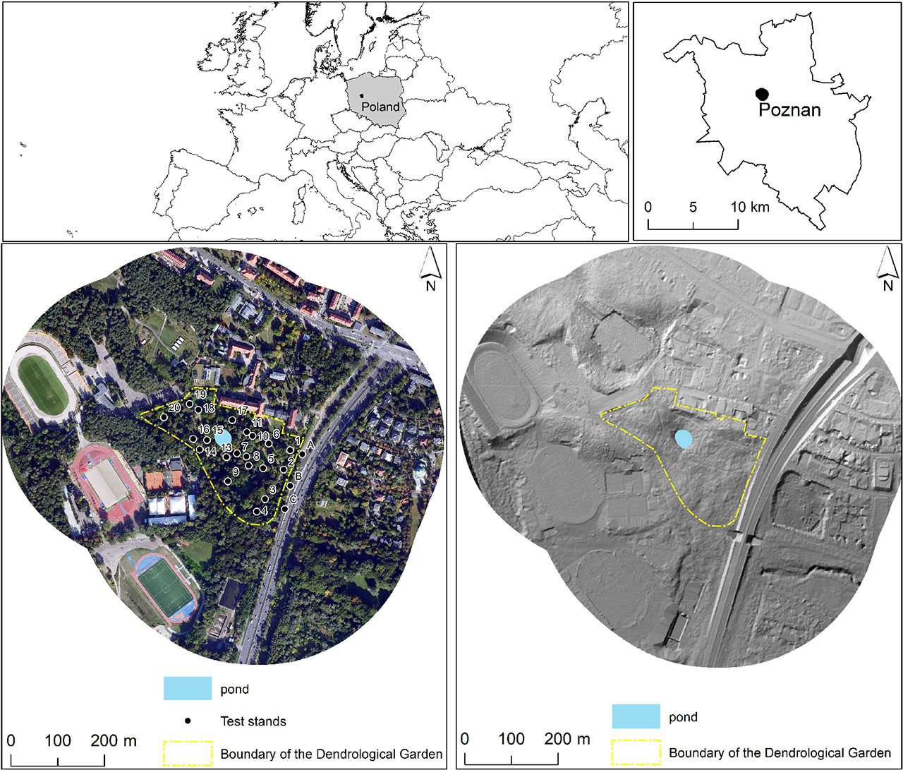
Figure 1.
Study site location with satellite and LIDAR-derived images
Source: own elaboration based on Geoportal
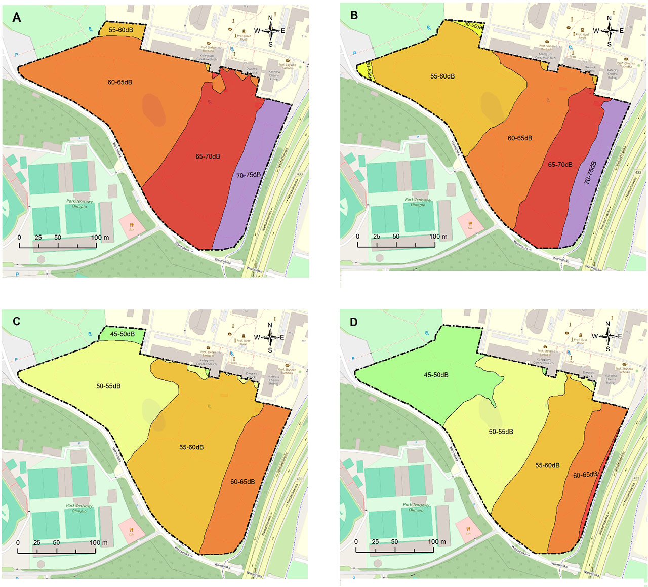
Figure 2.
Changes in noise ranges for the LDWN and LN indicators for 2012 and 2017
A - LDWN 2012, B - LDWN 2017, C - LN 2012, D - LN 2017
Source: own compilation based on acoustic maps of Poznań
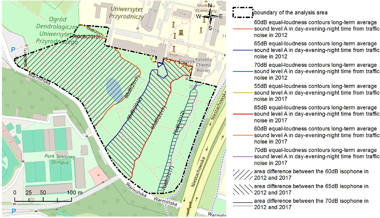
Figure 3.
Changes in the course of LDWN noise contours for 2012 and 2017
Source: own elaboration
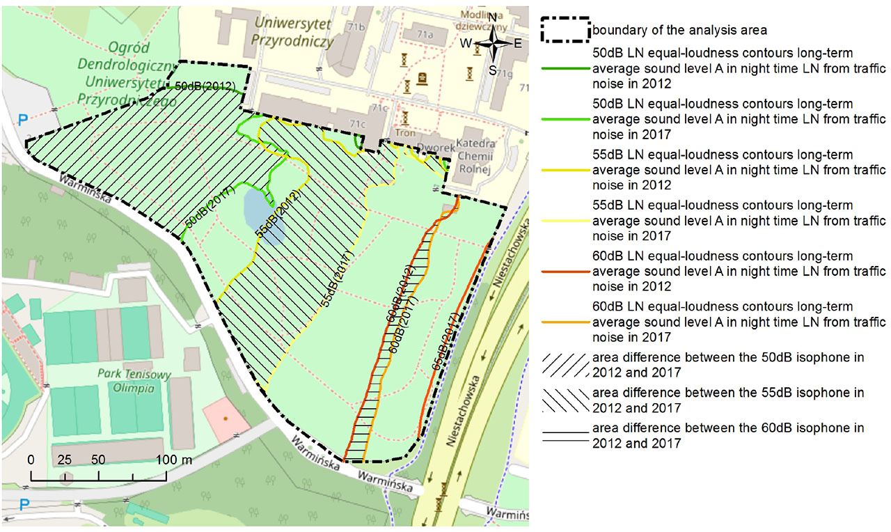
Figure 4.
Changes in the course of LN noise contours for 2012 and 2017
Source: own elaboration
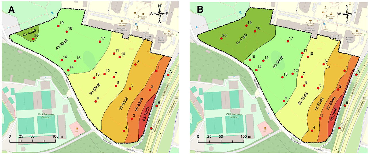
Figure 5.
Areas exposed to road noise within the limits of the study area on weekdays: A - LAeq
27 May 2014 (Tuesday), B - LAeq 9 June 2020 (Tuesday).
Source: own elaboration
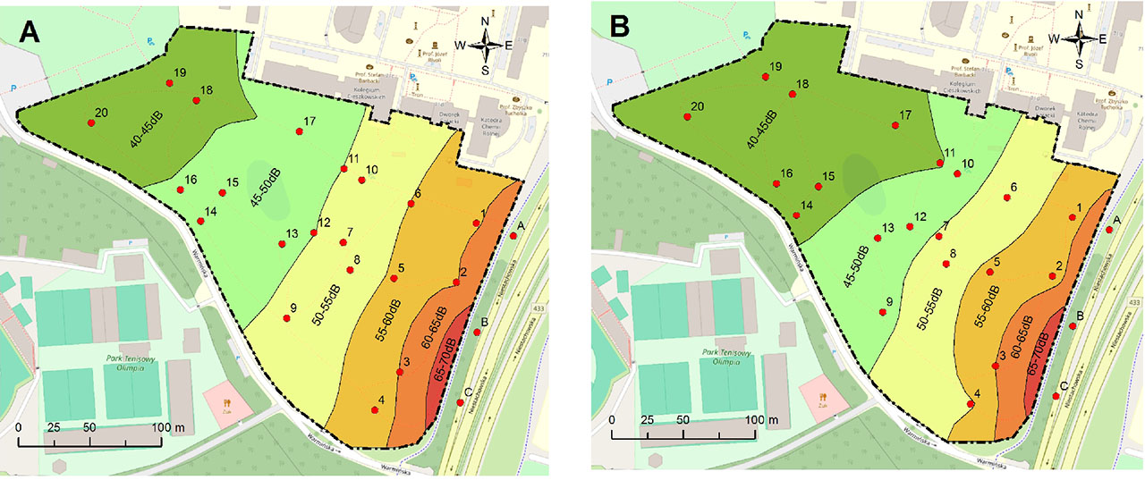
Figure 6.
Areas exposed to road noise within the limits of the study area on public holidays; A - LAeq 25 May 2014 (Sunday), B - LAeq 16 May 2020 (Saturday)
Source: own elabotarion
Table 1.
Changes in areas exposed to road noise described by LN and LDWN for the years 2012 and 2017
| No. | Features | Range [dB] | Code | Area [m2] | Index WCAR [-] | |
|---|---|---|---|---|---|---|
| 2012 | 2017 | |||||
| Area exposed to road noise in accordance with LN | 45–50 | ALN45-50 | 1,018 | 12,804 | 0.232 | |
| 50–55 | ALN50-55 | 16,461 | 16,380 | −0.002 | ||
| 55–60 | ALN55-60 | 23,634 | 13,613 | −0.198 | ||
| 60–65 | ALN60-65 | 9,596 | 7,293 | −0.045 | ||
| 65–70 | ALN65-70 | 0 | 619 | 0.012 | ||
| Area exposed to excessive noise, LN | >59 | A>59LN | 27.8% | 20.9% | ||
| Area exposed to road noise in accordance with LDWN | 50–55 | ALDWN50-55 | 0 | 750 | 0.015 | |
| 55–60 | ALDWN55-60 | 1,086 | 17,918 | 0.332 | ||
| 60–65 | ALDWN60-65 | 23,903 | 15,974 | −0.157 | ||
| 65–70 | ALDWN65-70 | 18,616 | 10,704 | −0.156 | ||
| 70–75 | ALDWN70-75 | 7,104 | 5,387 | −0.034 | ||
| Area exposed to excessive noise, LDWN | >68 | A>68LDWN | 28.1% | 18.8% | ||
Table 2.
Results of the LAeq analyses
| Site | 25 May 2014 | 27 May 2014 | 16 May 2020 | 9 June 2020 |
|---|---|---|---|---|
| LAeq | [dB] | |||
| 1 | 59.2 | 60.1 | 57.3 | 56.8 |
| 2 | 59.3 | 61.0 | 56.6 | 60.7 |
| 3 | 60.0 | 62.2 | 60.1 | 60.4 |
| 4 | 56.1 | 57.2 | 54.1 | 54.9 |
| 5 | 55.7 | 56.4 | 56.2 | 52.3 |
| 6 | 55.1 | 55.6 | 52.0 | 54.6 |
| 7 | 51.9 | 52.3 | 50.5 | 52.2 |
| 8 | 52.0 | 52.4 | 53.4 | 50.6 |
| 9 | 50.6 | 52.9 | 48.4 | 49.4 |
| 10 | 52.4 | 52.6 | 47.9 | 52.8 |
| 11 | 50.0 | 51.2 | 44.2 | 49.3 |
| 12 | 49.9 | 50.9 | 47.7 | 47.5 |
| 13 | 49.1 | 50.3 | 47.0 | 47.2 |
| 14 | 47.0 | 49.9 | 44.0 | 46.6 |
| 15 | 46.1 | 49.1 | 43.8 | 46.5 |
| 16 | 45.2 | 48.7 | 43.7 | 45.3 |
| 17 | 45.7 | 48.2 | 43.8 | 44.9 |
| 18 | 44.5 | 46.0 | 43.2 | 44.1 |
| 19 | 43.3 | 45.6 | 43.1 | 43.2 |
| 20 | 42.9 | 44.6 | 42.0 | 40.7 |
| A | 66.1 | 67.3 | 67.3 | 72.4 |
| B | 71.1 | 71.3 | 71.1 | 71.7 |
| C | 72.9 | 72.6 | 72.4 | 74.1 |
Table 3.
Changes in area of zones affected by road noise according to studies from the years 2014 and 2020 (average values)
| No | Feature | Acoustic range [dB] | Code | Area [m2] | WCAR Index [-] | |
|---|---|---|---|---|---|---|
| 27th May 2014 Tuesday | 9th June 2020 Tuesday | |||||
| 1. | Area exposed to road noise according to the index | 40–45 | A40–45 | 1058 | 10981 | 0.196 |
| 2. | 45–50 | A45–50 | 17143 | 15088 | −0.041 | |
| 3. | 50–55 | A50–55 | 15294 | 12858 | −0.048 | |
| 4. | 55–60 | A55–60 | 10575 | 6779 | −0.075 | |
| 5. | 60–65 | A60–65 | 5301 | 3744 | −0.031 | |
| 6. | 65–70 | A65–70 | 1338 | 1259 | −0.002 | |
| 7. | Percentage of area exposed to above-normal noise LAeqD | >65 | PA>65 | 2.64% | 2.48% | |
| 25th May 2014 Sunday | 16th May 2020 Saturday | |||||
| 8. | Area exposed to road noise according to the index | 40–45 | A40–45 | 9951 | 18237 | 0.163 |
| 9. | 45–50 | A45–50 | 13502 | 10857 | −0.052 | |
| 10. | 50–55 | A50–55 | 12899 | 10589 | −0.046 | |
| 11. | 55–60 | A55–60 | 9416 | 7219 | −0.043 | |
| 12. | 60–65 | A60–65 | 4053 | 3109 | −0.019 | |
| 13. | 65–70 | A65–70 | 888 | 698 | −0.004 | |
| 14. | Percentage of area exposed to above-normal noise LAeqD | >65 | PA>65 | 1.75% | 1.38% | |