
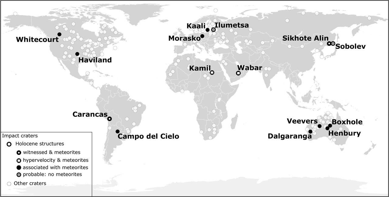
Figure 1.
Distribution of ~200 impact craters on Earth. Black circles indicate the location of Holocene structures: black circles with a small white circle inside show the location of craters whose formation was witnessed (Carancas and Sikhote Alin). Black circles with a white rectangle inside show the location of craters where shock metamorphic features were found (Kamil and Wabar). Fully black circles show the location of structures whose impact origin was confirmed solely by an association with meteorites. Black circles with a gray circle inside show the location of probable, but not confirmed, impact craters – ones that are not associated with known meteorites (Ilumetsa and Sobolev). The location of all other impact craters is shown using white circles
Source: own study based on Schmieder & Kring 2020, and articles listed in Table 1.
Table 1.
A list of Holocene impact craters sorted by the diameter of the largest structure. The list does not include features: (1) older than 10 ka (e.g., Douglas: Kenkmann et al. 2018); (2) terminal pits (e.g., Sterlitamak: Petaev 1992); (3) not confirmed yet by commonly accepted recognition criteria, described by French & Koeberl (2010). The list includes two structures (Ilumetsa and Sobolev) that are not associated with any identified meteorite fragments (so they are not officially confirmed) but circumstantial evidence suggests they were formed by an impact. The list also contains two confirmed craters (Dalgaranga and Veevers) whose age has only been estimated to be a couple of thousand years based on their morphology. Source: own study based on literature research – especially sources listed in the table.
| Crater Parameters | References | ||||||
|---|---|---|---|---|---|---|---|
| Crater | Country | Coordinates | Diameter of the largest crater [m] | Age | Impactor type | No. craters | |
| Carancas | Peru | 16° 39′ 52″ S; 69° 2′ 39″ W | 14 | 2007 AD | H4-5 | 1 | Tancredi et al. 2009 |
| Haviland | USA | 37° 34′ 57″ N; 99° 9′ 50″ W | 15 | 0.2 ka | Pallasite | 1 | Honda et al. 2002 |
| Dalgaranga * | Australia | 27° 38′ 6″ S; 117° 17′ 20″ E | 24 | ? | M.siderite | 1 | Hamacher et al. 2013 |
| Sikhote Alin | Russia | 46° 9′ 36″ N; 134° 39′ 12″ E | 27 | 1947 AD | IIAB | 5 +n | Krinov 1971 |
| Whitecourt | Canada | 53° 59′ 56″ N; 115° 35′ 51″ W | 36 | 1.1 ka | IIIAB | 1 | Herd et al. 2008 |
| Kamil | Egypt | 22° 1′ 6″ N; 26° 5′ 16″ E | 45 | 2000 BC–500 AD | Iron, ungr. | 1 | Sighinolfi et al. 2015 |
| Sobolev ** | Russia | 46° 18′ 0″ N; 137° 52′ 0″ E | 53 | ? / <1 ka | ? | 1 | Khryanina 1981 |
| Campo d. Cielo | Argentina | 27° 36′ 35″ S; 61° 40′ 53″ W | 65×105 | 4 ka | IAB | 4 +n | Cassidy et al. 1965 |
| Ilumetsa ** | Estonia | 57°57′36″N; 27°24′11″E | 80 | 7 ka | ? | 2 | Losiak et al. 2020 |
| Veevers * | Australia | 22° 58′ 12″ S; 125° 22′ 21″ E | 80 | ? | IIAB | 1 | Shoemaker et al. 2005 |
| Morasko | Poland | 52° 29′ 25″ N; 16° 53′ 48″ E | 100 | 5 ka | IAB-MG | 7 | Szokaluk et al. 2019 |
| Kaali | Estonia | 58° 22′ 22″ N; 22° 40′ 10″ E | 110 | 3.5 ka | IAB | 8 | Losiak et al. 2016 |
| Wabar | Saudi Arabia | 21° 29′ 58″ N; 50° 28′ 7″ E | 116 | ~19th century | IIIA | 5 | Gnos et al. 2013 |
| Henbury | Australia | 24° 34′ 19″ S; 133° 8′ 53″ E | 157 | 4.2 ka | IIIAB | 13 | Shoemaker et al. 2005 |
| Boxhole | Australia | 22° 36′ 46″ S; 135° 11′ 43″ E | 170 | 3 ka | IIAB | 1 | Shoemaker et al. 2005 |
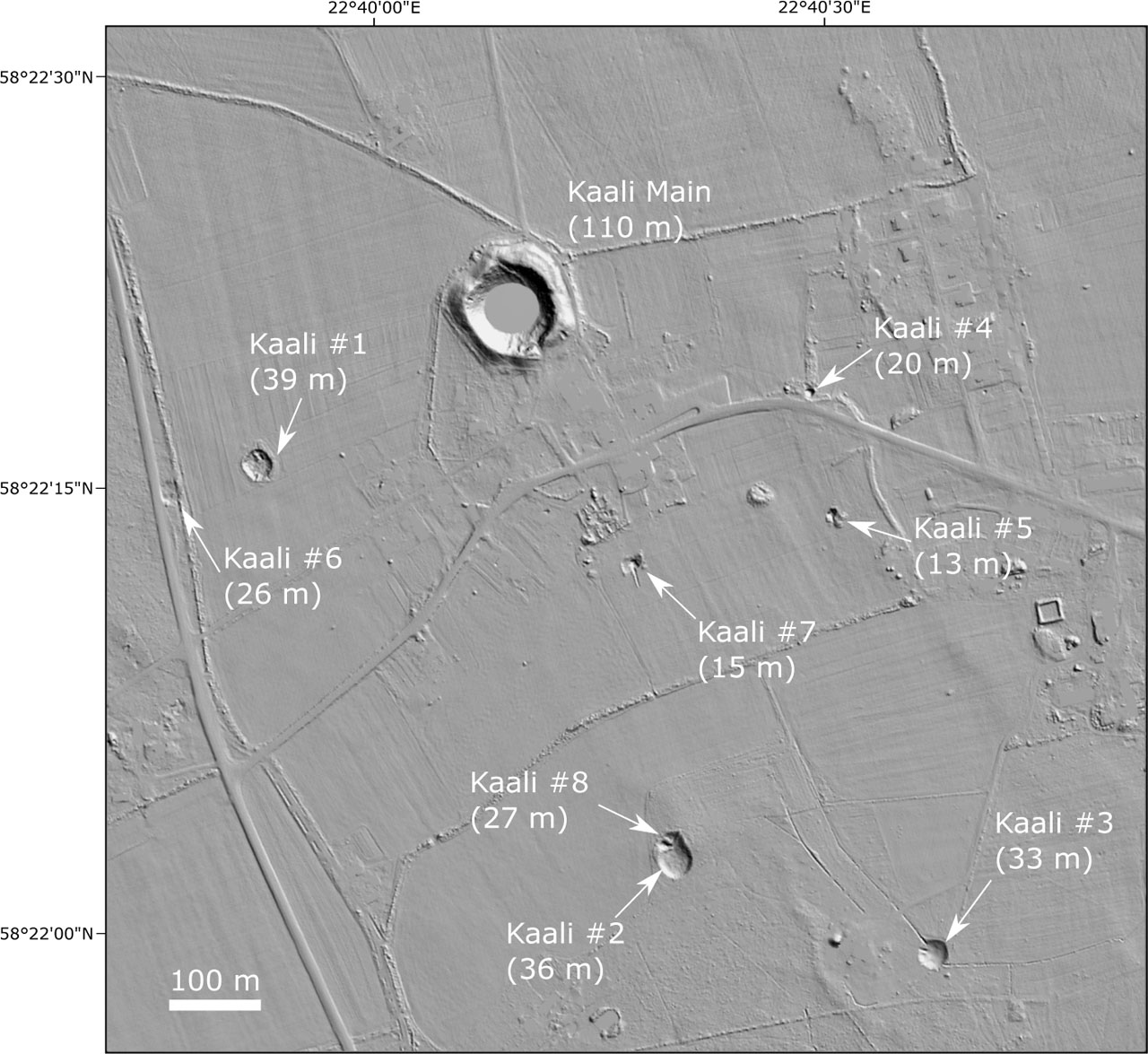
Figure 2.
Kaali crater strewn field
Source: own work based on LIDAR data from the Estonian Land Board 2023