
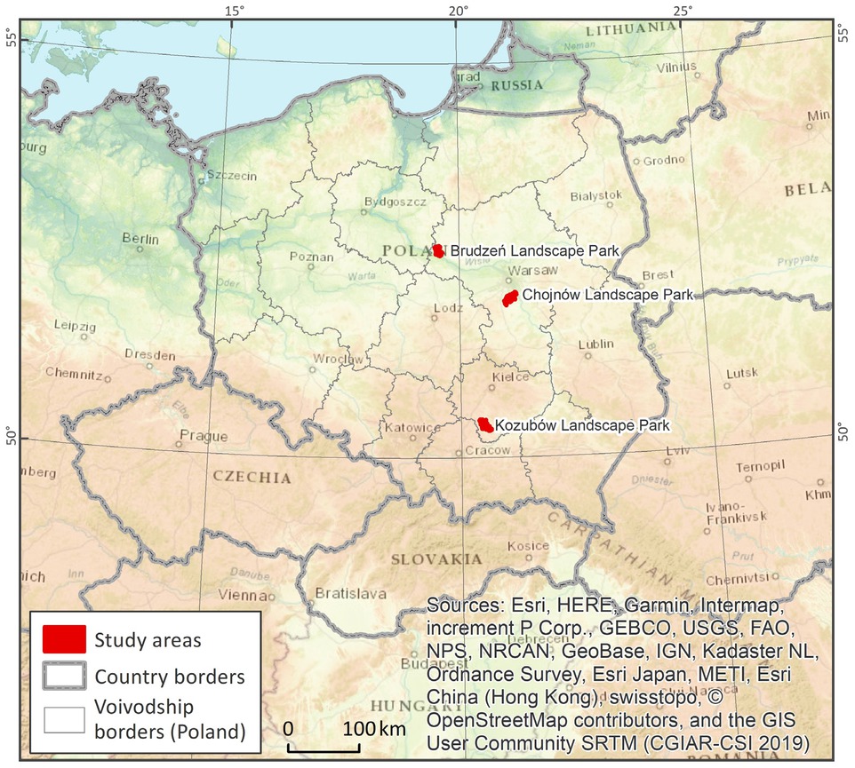
Figure 1
Location of study area in the context of Poland
Table 1
Classification of relief, typology and identified landscape types, according to: A –Annex 2 of the Regulation on the Principles of Preparing Landscape Audits of 11 January 2019 (source: own work); B – The method used in preparing Landscape Parks’ Conservation Plans (source: own work based on Cieszewska et al. 2018)
| Relief typology | Identified landscape types, abbreviations from maps | ||
|---|---|---|---|
| Brudzeń Landscape Park | |||
| A | - Plains - Valleys | A | LB - Forested landscape on coniferous habitats in valleys/on plains |
| LL - Forested landscape on deciduous habitats in valleys/on plains | |||
| LOB - Forested landscape on riparian and swampy habitats in valleys | |||
| WRm - Rural landscape with predomination of agricultural land use mosaic with small-sized plots on plains | |||
| WRs - Rural landscape with mosaic of agricultural land use with medium-sized plots on plains | |||
| WZ - Rural landscape with predomination of rural settlements on plains | |||
| B | - long slopes of wide river valleys - plains of postglacial upland - wide river valleys with short slopes - narrow valleys with short slopes | B | WL - Forested landscape on postglacial upland plains |
| WMZ - Mosaic landscape of built up areas and fields on postglacial upland plains | |||
| WMP - Mosaic landscape of fields and built up areas on postglacial upland plains | |||
| WP - Fields landscape on postglacial upland plains | |||
| WZ - Settlement's landscape on postglacial upland plains | |||
| DwMkz - Mosaic of forests, meadows and fields in wide river valleys with short slopes | |||
| DsMLkz - Mosaic of forests, meadows and fields in narrow valleys with short slopes | |||
| DZL - Forested landscape on long slopes of wide river valleys | |||
| DZM - Mosaic landscape of fields and forest on long slopes of wide river valleys | |||
| Chojnów Landscape Park | |||
| A | - Plains - Valleys - Hills | A | LL - Forested landscape with deciduous habitats on plains/in valleys |
| LOB - Forested landscape on riparian and swampy habitats in valleys/on plains | |||
| WZs - Rural landscapes with artificial water reservoirs on plains/in valleys | |||
| WRm - Rural landscape with predomination of agricultural land use mosaic with small-sized plots on plains | |||
| WZ - Rural landscape with predomination of rural settlements on plains | |||
| WRs - Rural landscape with agricultural land use mosaic with medium-sized plots on plains | |||
| MRp - Mosaic landscape with predomination of post-agricultural areas on plains | |||
| PMLZ - Suburban and forest settlements landscape on plains | |||
| GEOz - Mining areas of finished opencast mining on plain | |||
| B | - bottoms of valleys with breeding ponds - other river valleys - river valleys evidently incised - depressions filled with wetlands - plains of postglacial upland - dunes - steep slopes of postglacial uplands - alluvial plains | B | LW - Forested landscape on dunes |
| LR - Forested landscape on postglacial upland plains | |||
| LRZ - Forested landscape with built-up areas on postglacial upland plains | |||
| DWL - Landscape of river valleys evidently incised with meadows and woodlots | |||
| DL - Landscape of other river valleys with meadows and woodlots | |||
| LOW - Landscape of depressions filled with wetlands covered by forest | |||
| LLOW - Landscape of depressions filled with wetlands covered by meadows | |||
| WP - Postglacial landscape of upland plains with predomination of fields | |||
| DP - Landscape of alluvial plains covered by fields | |||
| WMPS - Postglacial landscape of upland plains with mosaic of fields and orchards | |||
| WMPL - Postglacial landscape of upland plains with mosaic of fields, meadows and woodlots | |||
| KL - Landscape of postglacial uplands steep slopes covered by forest | |||
| WZ - Postglacial landscape of upland plains with predomination of single family houses with gardens | |||
| WZO - Postglacial landscape of upland plains with compact housing estate | |||
| WS - Landscape of bottoms of valleys with breeding ponds | |||
| Kozubów Landscape Park | |||
| A | - Plains - Valleys - Hills | A | LL - Forested landscape with deciduous habitats on hills |
| WRw - Rural landscape with predominance of ribbon-like bands of small arable fields, meadows and pastures on hills/in valleys | |||
| WRm - Rural landscape with predomination of agricultural land use mosaic with small plots on hills | |||
| WRs - Rural landscape with predominance of agricultural land use mosaic with medium-sized plots on plains | |||
| WZ - Rural landscape with predominance of rural built up areas on plains | |||
| B | - bottoms of river valleys - loess areas with predominantly slightly inclined slopes - varied loess relief locally with outcrops of marl and other carbonate rocks - varied hill relief on marl outcrops and other carbonate rocks - plains of river accumulation - top parts of marl hills covered with loess | B | WL1 - Varied loess landscape locally with outcrops of marl and others carbonate rocks covered by forest |
| WL2 - Varied loess landscapes locally with outcrops of marl and other carbonate rocks in agricultural land | |||
| M1 - Varied hill landscapes on marl outcrops and other carbonate rocks covered by forest | |||
| M3 - Varied hill landscapes on marl outcrops and other carbonate rocks covered by xerothermic meadows | |||
| GL2 - Landscape of top parts of marl hills covered with loess covered by agricultural land use mosaic with small-sized plots | |||
| L2 - Loess landscapes with predominantly slightly inclined slopes with mosaic of agricultural land with small-sized plots | |||
| D2 - Landscape of river valleys bottoms with mosaic agricultural land with small-sized plots | |||
| Z1 - Landscapes of river accumulation plains covered by rural settlement | |||
Table 2
Comparison of the number and types of divisions between Annex 2 of the Regulation on the Principles of Preparing Landscape Audits of 11 January 2019 and the authors’ method used in Landscape Parks Conservation Plans.
| Landscape Park | Annex 2 of the Regulation of 11 January 2019 | Method used in Regional Parks Conservation Plans | Summary of diferences between the authors’ method and the Regulation | ||
|---|---|---|---|---|---|
| No of landscape types | No of relief types | No of landscape types | No of relief types | ||
| Brudzeń | 6 | 2 | 9 | 4 | The ranges of valleys are more precisely defined. The main areas of the plains have been retained. Other types are diferent. |
| Chojnów | 10 | 3 | 15 | 8 | The ranges of valleys are more precisely defined. The main areas of the plains have been retained. Other types are diferent. |
| Kozubów | 6 | 3 | 8 | 6 | The ranges of the valleys are similar. Other types are different. |
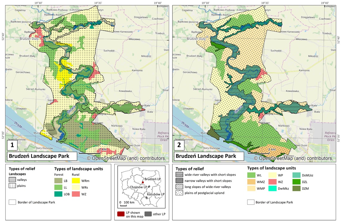
Figure 2
A comparison of landscape types as a result of a landscape audit for the Brudzeń Landscape Park Conservation Plan (source: own work and © OpenStreetMap contributorshttps://www.openstreetmap.org/copyright) A – Annex 2 of the Regulation on the Principles of Preparing Landscape Audits of 11 January 2019 (source: own work); B – Used in Landscape Parks’ Conservation Plans (source: own work, based on Cieszewska et al. 2018). (Abbreviations explained in Table 1.)
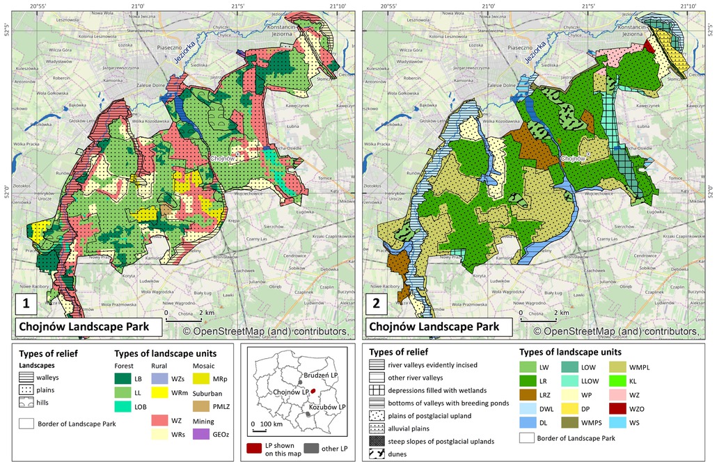
Figure 3
Comparison of landscape types as a result of a landscape audit for the Chojnów Landscape Park Conservation Plan (source: own work and © OpenStreetMap contributorshttps://www.openstreetmap.org/copyright) A – Annex 2 of the Regulation on the Principles of Preparing Landscape Audits of 11 January 2019 (source: own work); B – The method used in Landscape Parks’ Conservation Plans (source: own work based on Cieszewska et al. 2018). (Abbreviations explained in Table 1.)
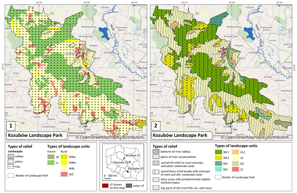
Figure 4
Comparison of landscape types as a result of a landscape audit for the Kozubów Landscape Park Conservation Plan (source: own work and © OpenStreetMap contributorshttps://www.openstreetmap.org/copyrightA – Annex 2 of the Regulation on the Principles of Preparing Landscape Audits of 11 January 2019 (source: own work); B – the method used in Landscape Parks’ Conservation Plans (source: own work based on Cieszewska et al. 2018). (Abbreviations explained in Table 1.)