
Introduction
“We are like dwarfs on the shoulders of giants”: so wrote Bernard of Chartres in the twelfth century (Metalogicon, III, 4). That’s a metaphor which intends to express the dependence of the modern culture on the ancient, and it’s very adequate for the rediscovery of the important knowledge assets of the Grand Tour’s literature. Through long stays in Europe and in Italy, many traveller-writers have described the characteristics of the areas visited from a critical point of view, highlighting their strong and weak elements with great wit and sense of observation. One of the most significant and unknown works concerning this literary current is the tale of the trip from Paestum to Policastro, made in 1828 by Craufurd Tait Ramage: his sketchbooks are not only a description of the evidence of the past and of the archaeological remains of Ancient Greece, but a small geo-history of the Cilento (shortly before its insurrection of that same year), as the first stage of a journey that brought back a fresco of the South of Italy, as it was before the process of Italian unification, with respect to its agricultural landscapes, customs and dietary habits, attitudes, superstitions, society, culture, religious and political affairs. So Ramage’s writings try to bring into focus such important aspects of the anthropic and natural geographical landscapes traversed, and they can help us, inductively, to reconstruct their social and economic structure. Ramage’s trip therefore is an aesthetic and geographical description founded on a subjective and objective spirit, in which influences caused by observation of natural beauty are not limited to mere aesthetic contemplation but, through culture and skills of observation, they give voice to the territory and its testimonies. Therefore, in this literary work the fundamental parts of a geo-historical process, whose consequences are discernible today, are evident in the critical points of Southern Italy, and of Cilento in particular, according to the same dynamics which were already widely and effectively described two hundred years ago.
Travel literature, territory and geography
Over the past fifty years, the areas of geographical research have expanded, with an articulation of the idea that space is no longer only measurable with Euclidean geometric coordinates. In particular, the cognitive sciences and functionalist theories have led geographers to also study the “invisible” aspects of landscapes (Ruocco 2010), according to precise “grammars” (Vallega 2004). Therefore, from the 1990s onwards in the Italian scientific context, we can find a relationship between geography, literature, historic essays and criticism of travel literature. So, the research tools of geographers, together with those of sociologists and psychologists (cognitive and social), thus gave rise to “a new study and research paradigm which considers the travel experience and literary productions as useful not only to reconstruct the ‘geographies of the past’ and the contemporary ‘history of geographic knowledge’” (Scaramellini 2008, p. 39), but also to try to establish their respective contexts of reference. These, for the most part, revolve around the concept of landscape, understood as “space of artistic perception”, “container of myths, dreams, emotions” (Tosco 2007, p. 85) in an evocative dimension that – observes Quaini (2006) – raises more attractiveness than the strictly analytical aspects of the geography. So, since a long time ago, in addition to “classical” studies in travel literature (in a descriptive and historical-humanistic way), 1 the need to experiment with more innovative and “syncretistic” investigations has been established, from wider points of view (such as aesthetic and symbolic). 2
The literature of the Grand Tour, as an artistic, cultural and social matrix of production, 3 lends itself well to this purpose, confirming the famous allegory of “dwarfs on the shoulders of giants” attributed to Bernard of Chartres (Metalogicon, III, 4). In fact, this particular kind of literature increases geographical knowledge and, at the same time, “contributes to the construction of the myth of the landscape, and that of Italy in particular” (Mazzetti 2008 [a], p. 343), producing images that have become constitutive of a well-recognised identity, 4 cultural and territorial, rooted in real existing contexts, since even the places of myth, for the most part, “have a name, and correspond to real places” (Ferrari 2010, VIII, p. 386). In fact, the stories of the Grand Tour (spontaneous or commissioned by some publisher: Mazzetti 2008 [b]) in major European cities of the 18th and 19th centuries, 5 although giving importance to an experience reserved for the sons of aristocratic families (followed by bourgeois, writers and artists), 6 have undoubtedly the merit of telling the “physical, geological reality of the territory Italian, quite neglected until the second half of the eighteenth century” (Mazzetti 2008 [a], p. 342). It is certainly the case of valuable works such as the Voyage Pittoresque of the Abbot de Saint-Non and Goethe’s Journey to Italy, but also of some minor writings (excluding those of a stylised and stereotypical character). 7 Geographical-historical research on territorial conditions in the past few centuries can thus be aided greatly by some of these texts, appropriately integrated with other contemporary sources. 8
The Cilento, between collective imagination and geographical reality
Through these reflections, this contribution, with the support of historical maps and some well-known texts from the 17th to the 19th century, follows the travel diary in the Kingdom of the Two Sicilies by Craufurd Tait Ramage (1868), 9 minister of the Scottish church and professor of the sons of the English consul at the Court of the Bourbons of Naples. 10 Animated by strong cultural interests towards Greco-Roman antiquities (and like almost all the Grand Tour travellers, attracted by Vesuvius too), Ramage travels through the Neapolitan domains “al di qua del Faro” (further on from the Faro); the reference is to the lighthouse of Messina: the main subdivision of the Kingdom was between its continental part (Royal Domains on this side of the Faro) and Sicily (Royal Domains beyond the Faro) and a small part of the Papal State. 11 He thus drafts a fresco of the environmental, social, political and economic conditions of the pre-unitary South, only published in the form of correspondence in 1868, 12 when, as he himself explains, those “who favor the Constitution prevailed, while the supporters of the Bourbons, I am sure, have had a good lesson, with being subjected, at least in part, to the same pains and concerns that they inflicted on their opponents” (Ramage 2013, p. 27).
Leaving Naples in 1828, the real journey of Ramage starts from Cilento, a part of the ancient Lucania according to the geographical, erudite meaning of the time, 13 being part, from an administrative point of view, of the Districts of Vallo and Sala, in the province of “Principato Citra” [now province of Salerno], 14 or west Lucania. 15 Considered a closed world, with “traditions and customs of primitive mold”, “the land of the sad”, according to the definition of the Bourbon police, or “land of murderers and brigands, where violence was law anyway, the private revenge an undisputed principle” (Ramage 2013, pp. 49–50, 121), the “vast mountainous, and pleasant region of Cilento” [Ramage 2013, p. 38 (Fig. 1)], already disquieting because of its mysterious name (of late use but of ancient origin), 16 the uncertain
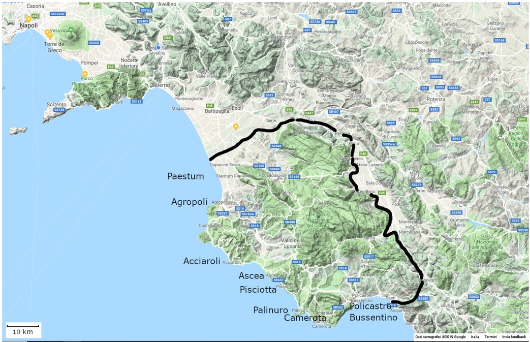
Figure 1
Delimitation of the Cilento area on Google Maps (black line introduced by the author).
The delimitation was implemented on the basis of a geographical definition of “Cilento” denoting the entire southern part of the province of Salerno, bordered to the north-east by the Marzano and Eremita mountains and, to the east, by the Vallo di Diano, starting from the plain to the left of the Sele river to the Gulf of Policastro.
boundaries, 17 the wild landscapes, the centres perched on steep and rough peaks, often deserted villages on the coast (Siniscalchi 2008).
The travellers of the time did not pass Paestum (already difficult to reach: Capano 2012, p. 140), “because the road was insecure, haunted by brigands, full of dangers”, 18 as Macfarlane warned, and again, several years later, Lenormant, who considered “the places beyond Paestum as lands where it was reasonable to make a will before entering” (Mazzetti 2008 [a], p. 342). Nevertheless Ramage leaves, alone and on foot (according to the Grand Tour), 19 equipped with geographical maps, 20 notebooks, straw hat and umbrella to protect himself from the sun (Ramage 2013, pp. 49–50 and p. 121). In a few days, going south and southeast, he reaches Agropoli, Torchiara, Il Mercato (today Mercato Cilento), goes up the summit of Monte Stella and heads towards Porcili (today Stella Cilento) and Acquavella; he crosses the Alento valley and visits Velia with its abandoned castle of Castellammare della Bruca, then Ascea, Pisciotta, Centola, Palinuro, Camerota, San Giovanni a Piro, Policastro and Sapri (Fig. 2).
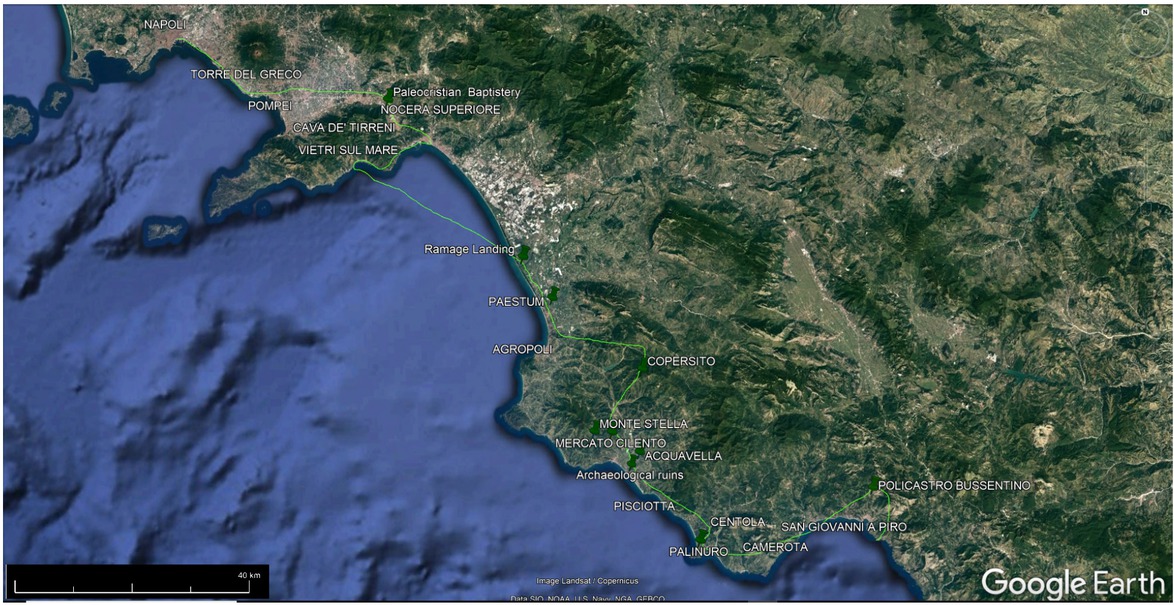
Figure 2
The main points of Ramage’s travel through Cilento, highlighted on a Google Earth satellite image (author’s underlining)
The Cilento through the Ramage journey
Through Ramage’s diary, the disintegration of the relations between city and territory of the Bourbon Kingdom appears clearly, already taken over by G.M. Galanti, T. Monticelli and subsequently, by C. Afan de Rivera. The story opens with the lively description of the path, riding in a calash from Naples to Salerno, already full of contrasts: the poverty of the population and magnificent landscapes (Ramage 2013, p. 38), chaotic traffic and deep bonds between community and environment, 21 urban discontinuity and architectural beauty, 22 miserable crops for people and livestock and rich farming for the afluent classes, 23 the decadence of the present and the prosperity of the past. 24
The backwardness of the south area of Salerno seems to be even more evident: here, during the stop in Paestum – reduced to a small number of houses 25 and afflicted by stagnant waters (Ramage 2013, pp. 48–49), with no trace of the old port, the ubication of which is still unclear (La Greca 2014, p. 57, and 2012, p. 62) – Ramage immediately experiences the environmental degradation and the poverty of the population, as the contemporary Atlas (Sheet 19) of Giovanni Antonio Rizzi Zannoni shows (Fig. 3).
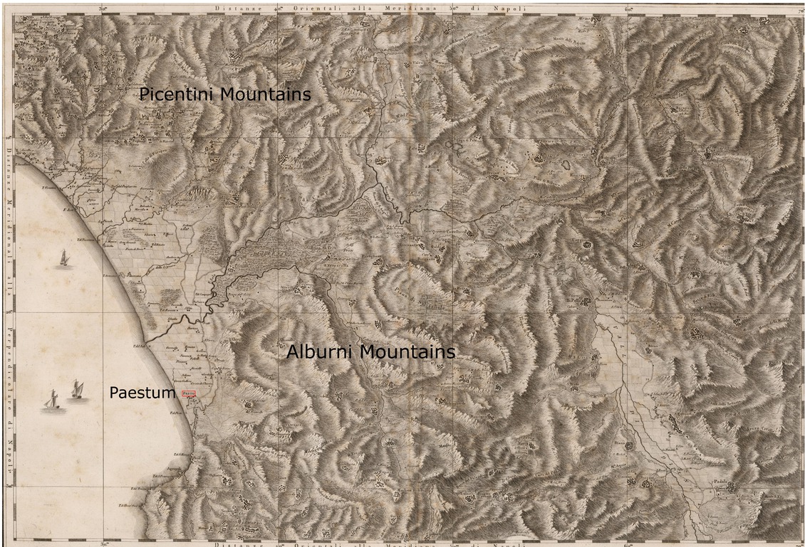
Figure 3
The Sele plain in an extract from Sheet 19 of the Atlante geografico del Regno di Napoli delineato per ordine di Ferdinando IV re delle Due Sicilie & C. & C. da Gio. Antonio Rizzi-Zannoni geografo di Sua Maestà e terminato nel 1808 [Geographical Atlas of the Kingdom of Naples outlined by order of Ferdinand IV King of the two Sicilies by Giovanni Antonio Rizzi-Zannoni, Geographer of His Majesty and completed in 1808]. Napoli, 1788–1812 (Firenze, Cartographic Archive, 11th group, Order No. 28, archive folder 85, doc. 5). Scale 1:126,000. As can be seen from the drawing, the plain and the area of Paestum, bounded to the north from the southern foothills of the Picentini Mountains and south from the Alburni Mountains, are impaludate, with riverbeds without embankments and control, and extensive cultivation of poor quality (changes and additions are introduced by the author).
The situation improves after the river Testene (deformation of the original name of “Pastena”, as discovered by Aversano and as we can see in the cartography of the seventeenth century), 26 with the climb to Mount Stella (1131m a.s.l.), from whose peak, distinguished by the ruins of an inhabited centre (which, as Ramage realises, are not those of ancient Petilia), 27 it is possible to enjoy an amazing view (Ramage 2013, p. 67), described by him with an appreciable geographical precision (which recalls, a century and a half in advance, that of the Italian geographer Aldo Sestini: 1963, p. 156). The environmental degradation re-emerges from the miasma of the Alento valley, swamped and without crops, after the rice fields had been the cause of even deadly diseases among the inhabitants. 28 The dry river 29 and the karst caves of Palinuro (more connoted by the myth than by real natural peculiarities) are disappointing for Ramage, contrary to the river Bussento (with its long underground path, caves and swallow hole), 30 and to the marshes of Policastro (abandoned by rich people in the hottest months, for fear of malaria: Ramage 2013, p. 133) and to the homonymous gulf, where the course of the river, returned to the surface several kilometres before, ends. The contrasts can still be seen in the hardened faces of the Cilentan citizens, grappling with a land that is unstable, not very generous, and torrid in summer (Yonder pp. 89–90), dispelling the belief in an idle southern population. Ramage, on its way to Torchiara and Il Mercato – site of annual fairs, as the toponym attests – experiences characteristics of the Cilentan territory that are still partly current: “small or mediocre-sized centres located on small hills, large spurs and shelfs, or on extreme slopes of limestone reliefs”, often dominated by “an ancient fortress or an old massive baronial palace” (Sestini 1963, p. 155), between blackened houses and uneven and rough roads (Ramage 2013, p. 59).
If “landscape modelled at a certain moment in history generally no longer works in later times” (Turri 2004, p. 171), the Cilentan one, persisting ancient forms and peculiar kinds of life (especially in the inland areas), has changed little, with positive (environmental and landscape preservation) and negative (economic-cultural backwardness, strong youth emigration) effects. 31 This is also demonstrated by the presence of many monasteries and convents of different monastic orders (Ramage 2013, p. 63), reduced in part to lay use after the French laws of subversion of feudalism. A circumstance that, despite the importance of the role of the religious for the development of the territory (especially during the Middle Ages), does not cause sorrow in Ramage, who experiences the superficiality and the rudeness of the local clergy, by now distant from the material and spiritual needs of the population (concerning this, see Ebner 1973 and 1982). It is precisely the hospitality and extreme poverty of this latter (Ramage 2013, pp. 80–81) that prompt him to grasp, with sympathy, a certain cultural affinity between Scotland and the Cilento (Yonder pp. 116–117), including brigands (Yonder p. 68).
Visiting Porcile [sic] (Porcili) and crossing the valley of Acquavella (whose division between a few rich cultivated lands and many others left uncultivated (Yonder p. 75) reveals its economic depression), Ramage understands the real danger of the latter; he reassures himself however during the journey to Ascea and Sapri. An ex-official of Murat shows him the olive oil, corn, meats and cured meats, together with dried figs, as the finest food products in the area (Fig. 4), 32 characterised by hills full of vineyards, olive trees, fig and oak trees, with houses surrounded by orange and lemon trees and lush apricot trees. On the other hand, the activities of the Ascea navy are not equally prosperous, because the fishermen are forced to yield half of their already modest earnings (derived mostly from the sale of anchovies and sardines) 33 to the tax collectors of the government, with the salt tax. 34 Ramage sees tax on the flour applied instead,
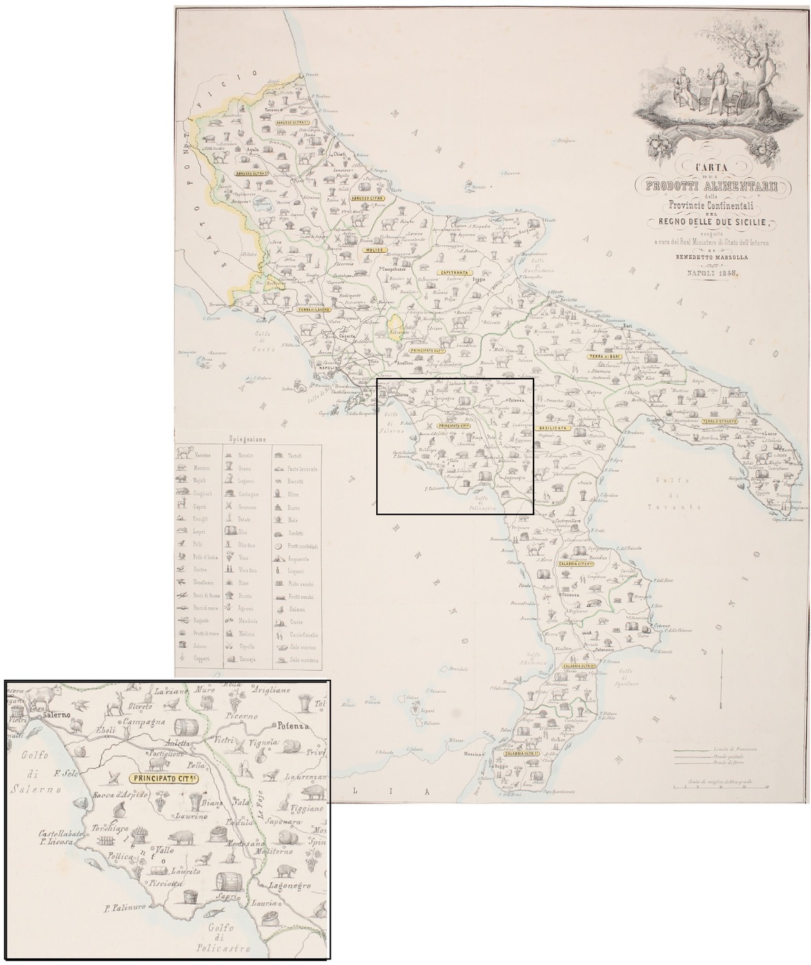
Figure 4
Benedetto Marzolla, Carta dei prodotti alimentari delle Provincie Continentali del Regno delle Due Sicilie [Map of food products of the Continental Provinces of the Two Sicilies Kingdom], Napoli 1856. Scale of 60 miles per degree (approximately 1:2,500,000). Also printed on silk, in very rare specimens, the map shows, through 51 figurative symbols, but without statistical data, an overall view on the distribution of raw materials and the various foods produced in the Kingdom of Naples. According to what Ramage writes, Cilento is characterised by the symbols of figs, dried fruit and wine near the coast, while, further inland, abundant salami, fresh fruit, pigs and, to the left of the Sele, corn. On the coast, on the other hand, we can see the symbols of a “Tonnaja” at the height of Agropoli and the capture of “sea fish” in the stretch between Agnone and Acciaroli (changes and enlargements are introduced by the author).
near Centola, on the river Molpa (now Lambro), 35 in one of the many parish mills controlled by the Bourbon government where the farmers had to bring the grain to grind.
Ramage is even more impressed by the “security card”, an annual renewal document that is obligatory for all the citizens of the Kingdom (but “almost unnoticed by the rich”), which they must wear (on pain of imprisonment). Nonetheless, in reference to this, the diary does not express negative evaluations (except indirectly: Yonder p. 103): Ramage, a foreigner travelling in the Kingdom of Naples at the end of the 1920s, knew he had to be careful.
A warranted precaution, considering the anti-government sectarian movements, 36 the role played by the Cilento in the revolution of 1799 37 and the bloody revolt that broke out between the months of June and July of that same year, 1828. 38 Ramage experiences this nervous climate in particular at Pisciotta (an ex-Masonic Lodge) and in Camerota, where he realises he should be wary, while at Policastro he finds an incandescent situation, both among the inhabitants and the Bourbon guards, looking for “certain unfortunate Carbonari” chased “almost like wild beasts” (Ramage 2013, p. 132). So he has the opportunity to notice an emblematic psycho-social trait of the Cilentans, bestowed with personal courage but wary and incapable of “giving life to an organized resistance” (Yonder p. 132). The suspicions of local authorities about him are also born of his (unintentional) meetings with some revolutionaries, including Don Teodosio De’ Dominicis, owner of the lands on which the ruins of Velia stood, and Ramage’s guide during the visit to the visible remains of the ancient city, at that time still buried. 39 The visit is an important moment of the journey, because Ramage describes what was left of ancient Velia 40 – the walls, a cistern, the tombstones and the medieval ruins of Castellammare della Bruca (as Velia was called during the Middle Ages) 41 – before the excavations of the end of the century, 42 discovering, to his detriment, that the medieval tower, used as a pigsty, was infested with fleas. A local antique dealer reveals to him the existence of a double port of the ancient city 43 (later confirmed by archaeological excavations 44) and the custom of landowners to hide, keep or resell the artefacts found at the antiques market in Naples (already famous for the sale of fakes). The following view of the so-called “tomb of Palinuro” arouses many perplexities in him instead: Ramage is not mistaken, since the Cenotaph is an ancient monument in Lucania erected to invoke the divine benevolence following pestilence (in this regard, see Greco 1975, pp. 94–95). Similarly, he notices the medieval origin of the remains of the presumed city of Melphes, on the mountain above the mouth of the river Molpa (today Lambro), as well as the stronghold of the city of Buxentum (today Policastro Bussentino), formerly a Roman colony and, earlier still, Greek, from which the Bussento river evidently gets its name. 45
Conclusions
Through Ramage’s diary we tried to roughly reconstruct a small geographical monograph of the Cilento before the Unification of Italy in, as much as possible, a holistic vision. Thus a direct connection emerged between the cultural isolation and the difficult relationship of the Cilentans with a hard and hostile environment, even more so because of the presence of problems and territorial fractures punctually recorded by the coeval and, in many ways, still current statistical analysis. The Cilento was in effect one of the “suburbs” of the Kingdom of Naples and Ramage experiences its state of abandonment, seeing the Cilentans deprived of the possibility of better life prospects, taking on a daily struggle for survival, from every point of view. Overcoming the initial prejudices, the Scotsman gets to the point of believing that the dangers to which his friends believed him exposed “exist only in their fervid imagination. I like everything I’ve seen of these people; nothing can exceed the goodness, courtesy and hospitality shown to me without distinction, by all those whom I have approached” (Ramage 2013, p. 89).
It therefore remains for us to reflect on the fact that the story of this travel experience shows the persistence of problems still existing: social marginalisation, bad roads, economic backwardness (between archaic agricultural structures and backward settlement of land), irrational exploitation of slopes, cultural forms of an extensive type, large extension of the productive harvest.
These are hurdles aggravated by the economic changes of post-World War II, with the emigration of thousands of Cilentans and the depopulation of the internal hilly areas, the company division, the process of tourist transformation of the coastal strip, the hydrogeological instability and the inadequate management of road infrastructure, of which the internal areas suffer, often isolated for days after floods. All these circumstances still make Cilento “a singular geographical entity closed” (Mautone 1990, p. 227) and “one of the weakest inland areas of the South” (Yonder p. 235), for which we continue to wait for sustainable development interventions (considering also the existence of the National Park of Cilento, Vallo di Diano and Alburni), accompanied by important infrastructural issues – especially of mobility/transport – of regional and interregional importance, already well identified by the Territorial Regional Plain of Campania (November 2006).