
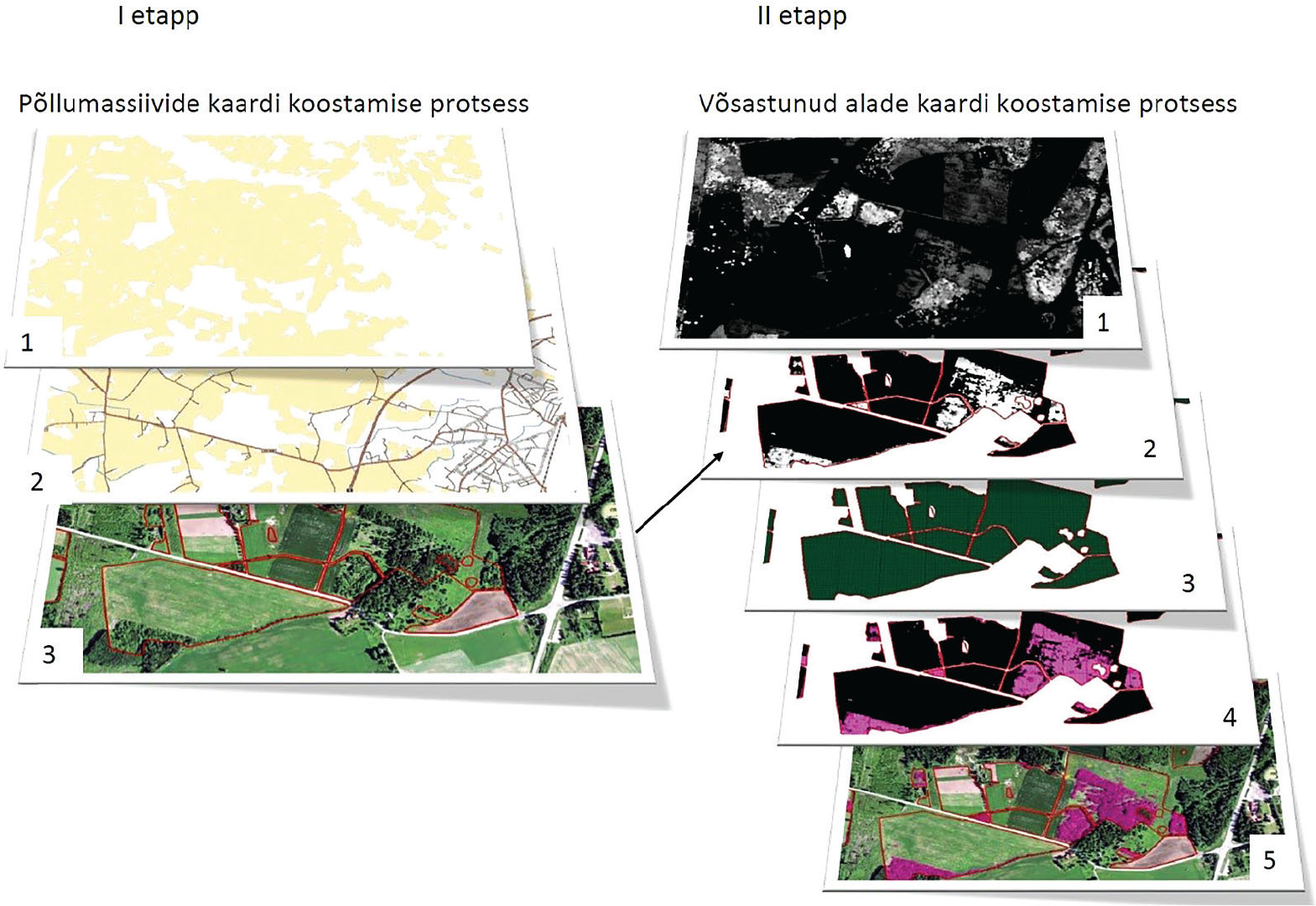
Joonis 1
Digitaalkaartide koostamise etapid.
Figure 1. Processing steps of digital map construction.
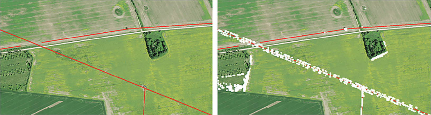
Joonis 2
Joonise vasakpoolsel osal on punase joonega tähistatud elektriliinid. Joonise parempoolsel osal on valgete punktidega tähistatud laserskaneerimisega tuvastatud maapinnast kõrgemad objektid.
Figure 2. The left part of the figure shows power lines marked with a red line. The right-hand part of the figure shows objects above the ground detected by laser scanning and marked with white dots.
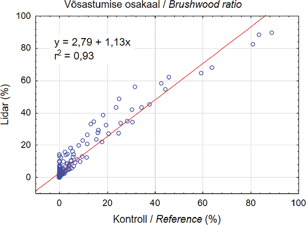
Joonis 3
Kahe erineva meetodiga määratud võsastunud alade vaheline korrelatsioon. X-teljel on ortofotodelt visuaalselt määratud võsastunud alade osatähtsus ja Y-teljel laserskaneerimisega saadud võsastunud alade osatähtsus põldudel.
Figure 3. Correlation between two different scrubland determination methods. The x-axis shows the ratio of the scrubland determined by visual inspection of orthophoto maps and the y-axis shows the ratio of the scrubland detected by laser scanning in fields.
Tabel 1
Uuritud põldude ruumilisi omadusi iseloomustavate näitajate kirjeldav statistika (vaatluste arv oli 6604).
Table 1. Descriptive statistics of spatial properties of investigated arable land plots (number of observations was 6,604).
| Põlde iseloomustavad näitajad / Characteristics of arable land plots | Keskmine / Average | Mediaan /Median | Miinimum / Minimum | Maksimum / Maximum | Standardhälve / SD |
|---|---|---|---|---|---|
| Pindala (ha) / Area (ha) | 12,8 | 3,9 | 0,3 | 239,1 | 22,3 |
| Kompaktsus / Compactness | 1,4 | 1,3 | 0,9 | 6,8 | 0,4 |
| Mulla boniteet / Soil productivity | 44,5 | 45,0 | 20,1 | 64,0 | 5,7 |
| Parandatud maa osatähtsus (%) / Ratio of ameliorated land (%) | 50,2 | 60,7 | 0,0 | 100,0 | 47,4 |
| Kaugus Tartust (km) / Distance to Tartu city (km) | 17,7 | 16,7 | 0,0 | 42,5 | 9,5 |
| Kaugus lähimast asulast (km) / Distance to nearest settlement (km) | 4,2 | 3,5 | 0,0 | 15,7 | 3,2 |
| Kaugus lähima riigiteeni (km) / Distance to nearest main road (km) | 0,5 | 0,2 | 0,0 | 5,3 | 0,7 |
| Kaugus lähima naaberpõlluni (m) / Distance to nearest neighbouring plot (m) | 17,0 | 6,0 | 0,0 | 2370,0 | 62,1 |
| Põldude konarlikkus / Roughness of plots | 0,9 | 0,7 | 0,1 | 3,9 | 0,53 |
Tabel 2
Lagedate ja võsaga põldude omaduste võrdlemine.
Table 2. Comparison of the characteristics of arable land plots without brushwood and with brushwood.
| Põlde iseloomustavad näitajad / Characteristics of arable land plots | Keskmine / Mean | t | p | Standardhälve / SD | F-ratio Variances | p Variances | ||
|---|---|---|---|---|---|---|---|---|
| I grupp/group | II grupp/group | I grupp/group | II grupp/group | |||||
| Pindala (ha) / Area (ha) | 16,39 | 7,37 | 16,39 | 0,00 | 25,03 | 15,94 | 2,47 | 0,00 |
| Kompaktsus / Compactness | 1,39 | 1,41 | −2,30 | 0,02 | 0,40 | 0,42 | 1,09 | 0,01 |
| Mulla boniteet / Soil productivity | 45,50 | 43,10 | 16,64 | 0,00 | 5,34 | 6,03 | 1,27 | 0,00 |
| Parandatud maa osatähtsus (%) / Ratio of ameliorated land (%) | 58 | 38 | 16,69 | 0,00 | 46,35 | 46,66 | 1,01 | 0,71 |
| Kaugus Tartust (km) / Distance to Tartu city (km) | 16,70 | 19,30 | −10,81 | 0,00 | 9,47 | 9,40 | 1,01 | 0,69 |
| Kaugus lähimast asulast (km) / Distance to nearest settlement (km) | 3,80 | 4,70 | −10,97 | 0,00 | 2,98 | 3,44 | 1,34 | 0,00 |
| Kaugus lähima riigiteeni (km) / Distance to nearest main road (km) | 0,47 | 0,51 | −2,35 | 0,02 | 0,69 | 0,66 | 1,07 | 0,07 |
| Kaugus lähima naaberpõlluni (m) / Distance to nearest neighbouring plot (m) | 12,80 | 23,30 | −6,77 | 0,00 | 44,74 | 81,20 | 3,29 | 0,00 |
| Põldude konarlikkus / Roughness of plots | 0,80 | 0,95 | −11,41 | 0,00 | 0,47 | 0,59 | 1,55 | 0,00 |
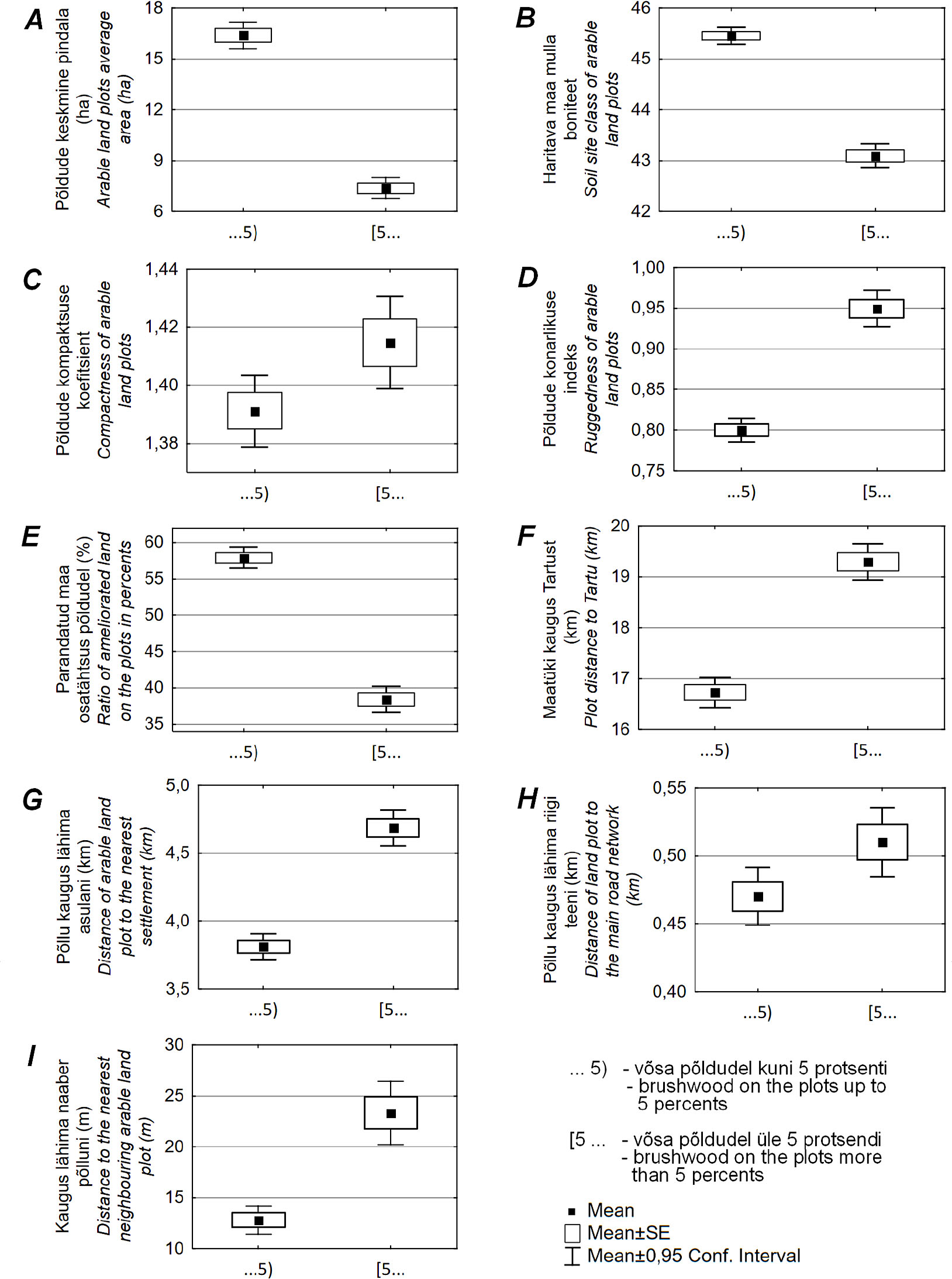
Joonis 4
Kirjeldavate tunnuste keskväärtused lagedate ja võsaga põldudel.
Figure 4. Comparison of the characteristics of arable land plots without brushwood and with brushwood.
Tabel 3
Logistilise regressiooni tulemused: mudeli parameetrite standardviga, statistiline olulisus (p-väärtus) ning šansside suhe.
Table 3. Logistic regression results for the model: standard error (SE), statistical significance (p) and odds ratio of variables.
| Põlde iseloomustavad näitajad / Characteristics of arable land plots | Standardviga / SE | p | Šansside suhe / Odds ratio |
|---|---|---|---|
| Vabaliige / Intercept | 0,256 | 0,012 | 1,888 |
| Pindala (ha) / Area (ha) | 0,002 | 0,000 | 0,975 |
| Kompaktsus / Compactness | 0,078 | 0,000 | 2,260 |
| Mulla boniteet / Soil productivity | 0,005 | 0,000 | 0,946 |
| Kaugus Tartust (km) / Distance to Tartu city (km) | 0,003 | 0,000 | 1,020 |
| Kaugus lähimast asulast (km) / Distance to nearest settlement (km) | 0,009 | 0,000 | 1,047 |
| Kaugus lähima naaberpõlluni (m) / Distance to nearest neighbouring plot (m) | 0,001 | 0,001 | 1,002 |
| Põldude konarlikkus / Roughness of plots | 0,053 | 0,000 | 1,294 |
| Parandatud maa osatähtsus (%) / Ratio of ameliorated land (%) | 0,058 | 0,000 | 0,600 |
[i] Model log likelihood ratio (LL) = 3987.26; AUC = 0.715; Adj.R2 = 0.100; Significance at p < 0.05.