
Introduction
The authors of (Dubyna et al. 2023) analyzed the current state of Ukraine’s protective forest belts. They established principles for optimizing the system of protective plantings and identified priorities for their restoration – a topic of particular relevance to the functioning of erosion control stands on ravine and gully lands.
Soil erosion caused by water is significantly exacerbated by climate change and human activities, posing significant threats to water resources and the ecological stability of the region. The studies conducted by the authors (Rashad et al. 2026) aim to evaluate current models of erosion processes within the central territorial province, as well as to forecast potential soil loss by 2050 and 2090. The results obtained make it possible to identify priority areas for implementing soil and water conservation measures with the aim of ensuring sustainable land use and preserving soil fertility.
The active occurrence of water erosion in Ukraine has led to the formation of over 362,000 hectares of ravines, of which more than 140,000 hectares are active. These are the consequences of the arable land coverage in Ukraine, which averages 55.2%, and of agricultural land coverage by region: Polissya – 72.5%; Forest-Steppe – 80.4%; Northern Steppe – 81.1%; and Southern Steppe – 82.1% (Malûga et al. 2023). Effective countermeasures against the development of erosion processes in the complex terrain of ravine and gully areas are implemented through phytomeliorative measures (Malûga 2020; Mìnder et al. 2019).
In the context of implementing the Sustainable Development Goals in Ukraine, the issues of restoring and protecting eroded soils have become particularly relevant. Erosion-control plantings, particularly Crimean pine (Pinus nigra subsp. pallasiana (Lamb.) Holmboe), established on ravine and ravine-valley lands in the Right-Bank Forest-Steppe, play an important role in these processes. The study (Malyuga and Minder 2021) covers an analysis of 90 soil and forest typological sites (270 samples), for which hydro-physical and agrochemical properties were determined using statistical methods. The authors established that soil properties gradually recover as the stands age, a finding confirmed by the correlation between the age periods of tree stands and indicators of their condition. The stages of ecological restoration of eroded areas were substantiated, and the key role of stands in stabilizing the environment was determined.
The study examined the specifics of establishing erosion control forest stands on steep, eroded slopes in the Podillia region of the Dniester River basin, particularly through the use of blasting methods for site preparation and terracing (Ol′hovs′kij 2002). It was established that the formation of planting pits with a diameter of 1.2–2.0 m and a depth of up to 0.8 m contributes to the improvement of the water-physical properties of the substrate and an increase in the survival rate of seedlings, which for Crimean pine and Scots pine (Pinus sylvestris L.) reached 90% or more. The effectiveness of using terraces (“base terraces”) 3.5–4 m wide for slope stabilization and ensuring favorable growing conditions has been demonstrated.
The use of container grown plants, particularly in plastic containers, increases survival rates to 74–96% and ensures better crop growth under challenging soil conditions. It has been observed that even on stony substrates with minimal soil cover, viable stands of Crimean pine form, reaching heights of 5–6 m at middle age. The results confirm the high effectiveness of forest reclamation measures for creating erosion-resistant stands under extreme conditions and their important role in stabilizing eroded landscapes (Ol′hovs′kij 2002).
The survival and survival rates of pine seedlings were assessed under various climatic and edaphic conditions along an altitudinal gradient. It was found that plantings with a closed root system yielded better results during the reforestation of eroded slopes (Lucas-Borja et al. 2022).
A mechanism has been identified for the physical transformation of soil mass by tree roots. This explains the observed inverse relationship between soil hardness and permeability beneath the canopy of pine stands (Gruba et al. 2023).
Studies examining changes in soil respiration in Pinus nigra stands of different age groups (0–10, 11–20, and 35–45 years) have shown that organic matter processes stabilize with age, which is important for interpreting soil improvement dynamics.
The authors of (Lucas-Borja et al. 2022), who studied the effect of afforestation with Pinus nigra (1968–2002) on nitrogen reserves under semi-arid conditions, confirmed a significant increase in SOC and TN following afforestation, which is comparable to results on chernozem soils and consistent with the accumulated experience of erosion control afforestation in Ukraine (Malûga 2020). Hydrological and afforestation measures implemented through a network of specialized stations, notably the Kaniv, Rzhyshchiv, and Norin stations, played a significant role in curbing erosion processes on ravine-and-balka lands. Their activities were aimed at stabilizing eroded areas by combining hydraulic structures with the creation of protective forest plantations. The further development of the forest reclamation system was ensured by the operation of an extensive network of forest reclamation stations, among which the Yampil Forest Reclamation Station (now the Yampil Forestry of the Zhmerynka Forest District, a branch of the “Central Forest Office” of the State Enterprise “Forests of Ukraine”) in Vinnytsia Oblast. The location of the study area and the distribution of the sample plots are presented (Fig. 1).
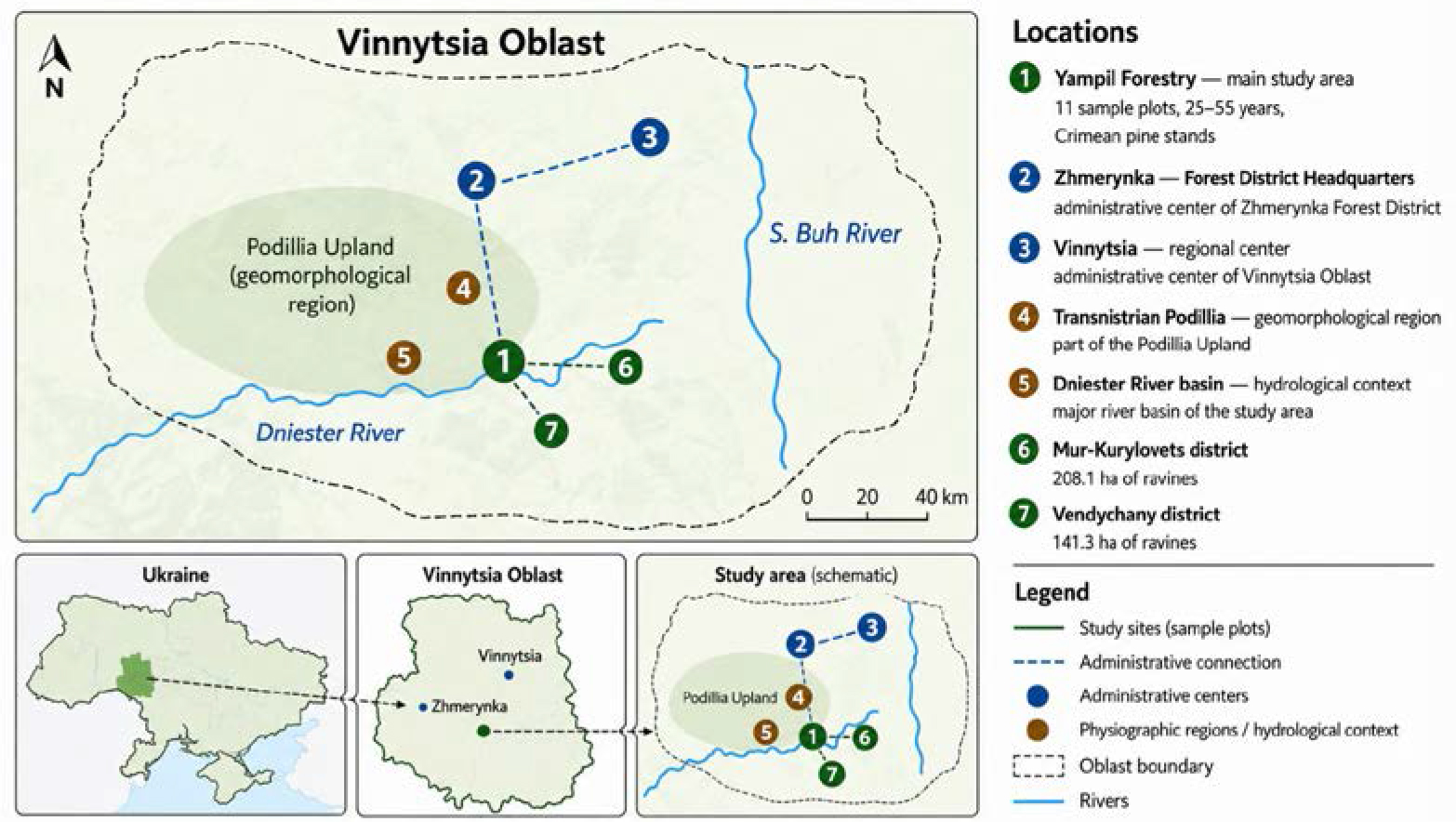
Figure 1.
Location of the study area and distribution of Crimean pine (Pinus nigra subsp. pallasiana (Lamb.) Holmboe) sample plots within the Yampil Forestry, Zhmerynka Forest District, Vinnytsia Oblast, Right-Bank Forest-Steppe of Ukraine
Source: Prepared by the authors based on (Zalìsnennâ erodovanih krutoshilìv…, 1999)
The Podillia Upland, particularly its Transnistrian section, is characterized by highly intense erosion processes: the terrain’s dissection index reaches 1–1.2 km·km-2, and the proportion of eroded soil accounts for approximately 30% of agricultural land. In response, forestry enterprises, in collaboration with scientific institutions, implemented a comprehensive set of erosion control measures, resulting in the creation of over 100,000 hectares of protective plantings (as of January 1, 2025). Plantings established within the Yampil Forestry of the Zhmerynka Forest District, a branch of the “Central Forest Office” of the State Enterprise “Forests of Ukraine”, have made a significant contribution to the stabilization of eroded lands in Podillia; their effectiveness confirms the feasibility of applying forest reclamation approaches in such natural conditions.
Researchers (Zhu and Song 2021) have systematized the ecological mechanisms underlying the functioning of protective forest stands. They examined the theory of protective maturity, structural-functional relationships, and ecological restoration strategies – a conceptual framework for interpreting the forest-improvement functions of Crimean pine stands.
A forecast of soil water erosion trends through 2070 has been provided, taking into account changes in land use and climate. It has been established that, without protective measures, erosion processes will intensify significantly. The role and importance of erosion control stands have been substantiated (Borrelli et al. 2020).
In today’s context of climate change and the availability of remote sensing technology, assessing the damage inflicted on Ukraine’s protective forest stands is of paramount importance. The authors were able to conduct a spatiotemporal analysis and identify the extent of damage and loss of windbreaks in various natural and climatic zones, particularly in the study region, which is caused by both direct anthropogenic impact and the disruption of the ecological balance of agricultural landscapes. As part of the study, protective stands were classified according to their functional purpose, specifically distinguishing windbreaks, erosion control shelterbelts and windbreaks (Matsala et al. 2025).
The results indicate that the degradation of erosion control stands is uneven, but the most critical consequences are associated with a reduction in their area. It has been established that these plantings play a key role in stabilizing landscapes, as they reduce the intensity of water and wind erosion, regulate surface runoff, stabilize the soil cover, and maintain the ecological balance of the territories. The loss or damage of erosion control forest strips leads to an intensification of degradation processes, a decrease in the productivity of agroecosystems, and an increased risk of further depletion of soil resources.
Thus, the study’s findings confirm the critical need to restore and expand the network of erosion control forest stands as an effective tool for ensuring sustainable land use and environmental safety.
A comprehensive assessment of the impact of climate change and land-use changes on the intensity of erosion processes in Ukraine has been conducted. Based on scenario modeling, potential soil losses were projected for 2050 and 2090, which allowed for the identification of long-term trends in soil cover degradation under conditions of intensifying climate change. It was established that rising air temperatures, changes in precipitation patterns, and an increase in the frequency of extreme weather events, combined with intensive agricultural land use, significantly increase the risks of water and wind erosion (Rashad et al. 2026).
The likely increase in the scale of topsoil loss in the future will pose a threat to the stability of agricultural landscapes and food security. In this context, the growing importance of establishing and restoring erosion control forest stands as an effective environmental protection measure is emphasized. Such stands help reduce surface runoff rates, increase soil infiltration capacity, mitigate deflation processes, and foster the development of agroecosystems that are more resilient to climate change.
Thus, the integration of erosion-control afforestation into climate change adaptation strategies is viewed as one of the key approaches to minimizing degradation processes and ensuring the long-term ecological sustainability of these areas.
The aim of this study was to comprehensively evaluate the silvicultural effectiveness of Crimean pine (Pinus nigra subsp. pallasiana) erosion-control stands in the Yampil Forestry by analysing stand growth, soil-improving capacity, soil physical properties, and the integrated condition of the stands.
To achieve this aim, the following objectives were addressed:
– to assess the silvicultural and mensurational characteristics of Crimean pine erosion-control stands of different ages;
– to evaluate age-related changes in soil physical properties and the integral soil improvement coefficient;
– to determine the relationships among root system development, soil hardness, and soil permeability;
– to perform an integrated assessment of stand condition using a composite indicator;
– to evaluate the applicability of the integrated assessment approach for monitoring the effectiveness of erosion-control forest plantations under the conditions of the Ukrainian Forest-Steppe.
Materials and Methods
The study of silvicultural and inventory indicators on sample plots was conducted using generally accepted and established methodologies (Ploŝì probnì lìsovporâdnì 2006). Soil hardness was determined using a Wile Soil penetrometer with a soil hardness scale, and water permeability was measured using steel cylinders 80 mm in diameter and 100 mm in height, which are tapered at the bottom for easy insertion into the soil. The cylinders are half-buried in the soil at the bottom, and the top 50 mm are filled with water. The water absorption time was measured using a stopwatch (Mìnder et al. 2019). The agrochemical properties of the soil were assessed based on the results of laboratory analyses of soil samples. To determine the soil improvement coefficients, the values of various soil properties obtained during field and laboratory studies were converted to relative values by comparing them with those obtained on control plots. The averaged data serve as the basis for calculating the actual integral soil improvement coefficients (Malûga 2020). A soil sampler was used to study root distribution and humus horizon depth (Malûga et al. 2013); root volume was determined using the xylometric method. The surface area of the main and active roots of the monolith was calculated using the average diameter of the fractions, which was measured with a caliper. The root surface area was calculated using the formula (Mìnder et al. 2019):
where S is the root surface area (cm2), V is the root volume (cm3), and D is the root diameter (cm). Condition analysis using the method for determining the integral condition index of forest stands (Hrik et al. 2024; Maliuha and Minder 2020; Maliuha et al. 2021; Maliuha et et al. 2024).Results and Discussion
The study area is located within the Yampil Forest District of the Zhmerynka Forest Region (Right-Bank Forest-Steppe of Ukraine) and is characterized by natural and climatic conditions typical of the region. The climate is temperate continental, with an average annual temperature of approximately +7.0 °C, annual precipitation of 480 mm, and a growing season lasting about 220 days. Uneven precipitation distribution and periodic droughts create conditions conducive to the development of erosion processes.
From a geomorphological perspective, the area belongs to the Pridnestrovsko-Podolsk region and is characterized by a highly dissected relief, the presence of ravines and gullies, as well as slopes with gradients of 5–45°, which results in a high risk of erosion. The proportion of degraded land is substantial, which justifies the creation and study of erosion control plantings, particularly Crimean pine (Pinus nigra subsp. pallasiana), as an effective means of stabilizing the soil cover.
The formation and functioning of forest ecosystems are determined not only by the biological characteristics of tree species, but also by specific environmental conditions shaped by the forest itself as an integrated natural system. According to the forest typological classification, the territory is differentiated by trophotypes (T) (A – coniferous forests, B – mixed coniferous forests, C – mixed broadleaf forests, D – broadleaf forests) and hygrotopes (H) (from 0 – very dry, 1 – dry, 2 – fresh, 3 – moist, 4 – damp and 5 – wet conditions,), reflecting gradients in soil fertility and moisture levels (Fig. 2).
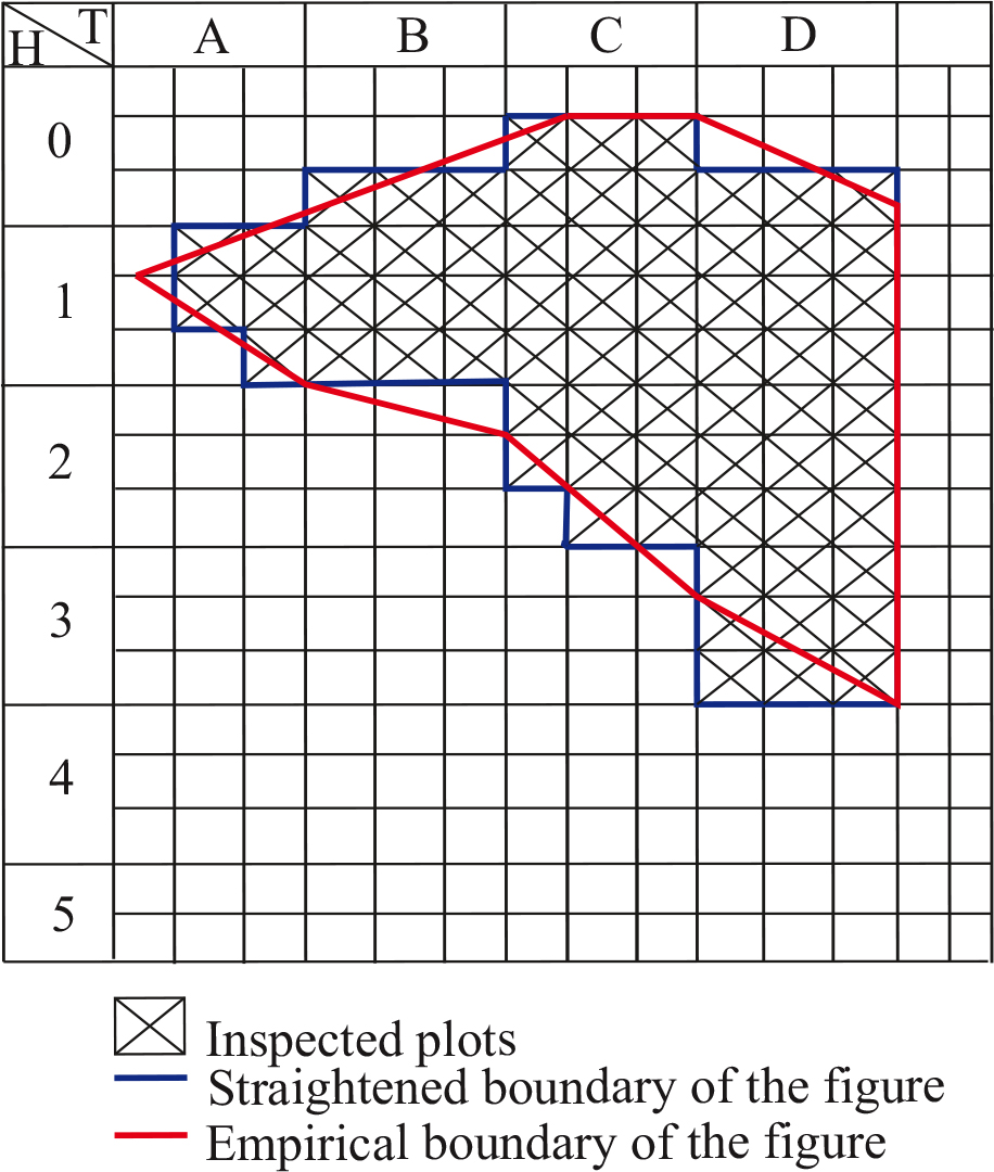
Figure 2.
Forest typological structure of Crimean pine stands within the jurisdiction of the Yampil Forestry Unit of the Zhmerynka Regional Forestry Administration, a branch of the “Central Forest Office” of the State Enterprise “Forests of Ukraine”
Source: Prepared by the authors
These natural, climatic, and edaphic conditions are the determining factors in the formation, growth, productivity, and health of Crimean pine stands (Pinus nigra subsp. pallasiana) within the Yampil Forestry of the Zhmerynka Forest District, a branch of the “Central Forest Office” of the State Enterprise “Forests of Ukraine,” and serve as the basis for their comprehensive assessment.
The morphological characteristics of typical soils in the study area are summarized and presented in Table 1, which shows the thickness of the humus horizon and the soil profile depending on the degree of erosion.
Table 1.
Morphological description of typical soils in the Yampil Forest District of the Zhmerynka Regional Forestry Administration, a branch of the “Central Forest Office” of the State Enterprise “Forests of Ukraine”
| Soil types | Thickness of the humus horizon, cm | Depth of soil profile, cm | |||
|---|---|---|---|---|---|
| H | H | Hp | HP | ||
| uneroded soils | slightly eroded soils | moderately eroded soils | severely eroded soils | ||
| Dark grey forest soils | 18–30 | 12–15 | 15 | 22 | 51–100 |
| Podzolized chernozem | 21–32 | 16–20 | 20 | 27 | 60–112 |
| Typical chernozem | 30–41 | 18–23 | 26 | 29 | 62–122 |
Table 2.
Distribution of soil types by degree of erosion
| Soil subtypes | Soil erosion degree, ha | In total, ha | ||
|---|---|---|---|---|
| low | medium | high | ||
| Grey forest soils | - | 29.0 | 21.0 | 50.0 |
| Dark grey forest soils | 28.8 | 119.6 | 18.0 | 166.4 |
| Podzolized chernozems | 44.0 | 65.2 | 109.3 | 218.5 |
| Typical chernozems | 501.1 | 673.2 | 492.8 | 1667.1 |
| Ordinary chernozems | 69.8 | 95.1 | 74.4 | 239.3 |
| In total | 643.7 | 982.1 | 715.5 | 2341.3 |
Uneroded soils are found on the watershed portions of flat areas; the slope gradients for slightly eroded soils range from 5 to 14 degrees, for moderately eroded soils from 18 to 23 degrees, and for heavily eroded soils from 25 to 30 degrees.
Ravines cover 436.9 ha (5.1%) of the total area of the Yampil Forest District, which is part of the Zhmerynka Regional Forestry Administration of the “Central Forest Office” branch of the State Enterprise “Forests of Ukraine.” They are found in all production districts, but the largest areas are in the Mur-Kurylovets (208.1 ha) and Vendychan (141.3 ha) work districts. Their distribution across the remaining sections is somewhat limited: the Petrashivska work section – 59.5 ha, the Severynivska work section – 28.0 ha. It is worth noting that a significant portion of the ravines in the study area are in the stabilization phase and have ceased active development. To further limit erosion processes and stabilize the ravines, it is advisable to use root-sprout tree and shrub species, including Robinia pseudoacacia, Ulmus minor, Prunus spinosa, Rosa spp., Crataegus spp., Elaeagnus angustifolia, Cotinus coggygria, Hippophae rhamnoides, Lycium spp., and others.
In the Yampil Forest District of the Zhmerynka Regional Forestry Administration, a branch of the “Central Forest Office” of the State Enterprise “Forests of Ukraine,” the impact of pure stands of Crimean pine (1.0) growing on ordinary chernozems with low to moderate degrees of leaching was studied. The mechanical and physicochemical composition of the soil is presented in Tables 3 and 4.
Table 3.
Mechanical composition of ordinary heavy loam chernozem in the conditions of the Murano-Kurylovetska work site of the Yampil Forestry, Zhmerynka Forest District, branch of the “Central Forest Office” State Enterprise “Forests of Ukraine”
| No. | Genetic horizons | Depth of samples, cm | Losses during cultivation | Sand, % | Dust, % | Silt < 0.001 mm, % | Amount > 0.01 mm, % | Amount < 0.01 mm, % | |||
|---|---|---|---|---|---|---|---|---|---|---|---|
| 1,0–0,25 mm | 0,25–0,05 mm | 0,05–0,01 mm | 0,01–0,005 mm | 0,005–0,001 mm | |||||||
| 47 | Hк | 0–28 | 3.30 | 0.60 | 21.12 | 21.60 | 21.75 | 6.54 | 25.09 | 46.62 | 53.38 |
| HPк | 30–40 | 2.20 | 0.40 | 7.44 | 37.18 | 19.06 | 3.35 | 30.37 | 47.22 | 52.78 | |
| Phк | 70–80 | 8.90 | 0.70 | 2.35 | 42.63 | 12.86 | 2.09 | 39.35 | 45.70 | 54.30 | |
| P(h)к | 90–100 | 37.20 | 2.50 | 25.87 | 25.43 | 9.77 | 5.50 | 30.93 | 50.80 | 46.20 | |
Table 4.
Physicochemical composition of ordinary heavy loamy chernozem in the Murovano-Kurylivetskyi work area of the Yampil Forestry Unit, Zhmerynka Forest District, “Central Forest Office” Branch State Enterprise “Forests of Ukraine”
| No. | Genetic horizons | Depth of samples, cm | pH hydrogen | Total exchangeable bases, MG-eq. per 100 g of soil | Composition of the soil absorption complex in MG-eq per 100 g of soil | Humus according to Turin, % | Total nitrogen, % | C N | MG per 100 g of soil | |||
|---|---|---|---|---|---|---|---|---|---|---|---|---|
| calcium | magnesium | P2O5 | K2O | nitrogen, which hydrolyzes | ||||||||
| 47 | Hк | 0–28 | 7.5 | 22.93 | 19.65 | 3.28 | 1.83 | 0.16 | 7 | 0.8 | 22.5 | 8.12 |
| HPк | 30–40 | 7.5 | 22.67 | 19.67 | 3.00 | 0.73 | 0.06 | 7 | 0.8 | 18.7 | 6.44 | |
| Phк | 70–80 | 7.8 | 24.36 | 21.54 | 2.82 | 0.55 | 0 | 0 | 0 | 0 | 0 | |
| P(h)к | 90–100 | 7.9 | 16.68 | 14.02 | 2.66 | 0.69 | 0 | 0 | 0 | 0 | 0 | |
A comprehensive analysis of the processes of physical and chemical degradation of agricultural soils in Ukraine has been conducted (Menshov and Kruglov 2023). Particular attention was paid to assessing the extent of eroded lands within the Forest-Steppe and Steppe zones, where intense erosion processes are caused by a combination of natural and climatic factors and longterm anthropogenic pressure. It was established that degradation changes manifest themselves in a decrease in humus content, deterioration of soil structure and aggregate state, reduction in water-holding capacity, and disruption of the balance of essential nutrients.
The results obtained indicate a significant prevalence of eroded and degraded soils, accompanied by a loss of their productivity and ecological functions. In this context, the need to implement effective erosion control measures is justified, among which field protection and erosion control afforestation play a key role. The establishment of forest stands helps reduce surface runoff rates, increase the soil cover’s resistance to water and wind erosion, improve microclimatic conditions, and stimulate soil fertility restoration processes.
A consistent trend in the integral soil improvement coefficients has been established depending on the age stages of growth and development of Crimean pine (Pinus nigra subsp. pallasiana) stands. Analysis of the data indicates that in the age range of 7–70 years, these coefficients gradually increase from 120% to 180% (Malyuga and Minder 2021), reflecting the gradual restoration of the properties of eroded soils.
The observed changes are consistent with the identified stages of growth and development of protective forest stands in ravine and gully areas, where soil improvement processes are directly linked to the stages of stand formation (Malûga 2020). Thus, the dynamics of the integrated indicators confirm the effectiveness of forest-based soil restoration as Crimean pine stands develop.
A comparative analysis was also conducted on the impact of pine trees on the formation of organic carbon inputs and the transformation of the chemical properties of reclaimed soils of different ages (Gruba et al. 2022). The results indicate a clear age-dependent trend in the recovery of soil parameters: as the age of the stands increases, there is a gradual rise in the content of hydrolyzable nitrogen in the upper soil horizons, indicating an intensification of biogeochemical element cycling processes.
The dynamics of the integral soil improvement coefficients for pure stands of Crimean pine (Pinus nigra subsp. pallasiana) on chernozem soils is described by a linear regression model (y = 0.819x+115.52), which reflects the dependence of this indicator on the age of the stands (Fig. 3). Here, the variable x corresponds to the age of the stands (years), while the variable y characterizes the value of the integral soil improvement coefficient (%). The obtained value of the coefficient of determination (R2 = 0.91) indicates a high level of model fit and confirms a close relationship between the age stages of stand development and changes in their soil-improving capacity, allowing the age of stands to be considered one of the key factors in shaping edaphic conditions and enhancing the ecological efficiency of forest ecosystems.
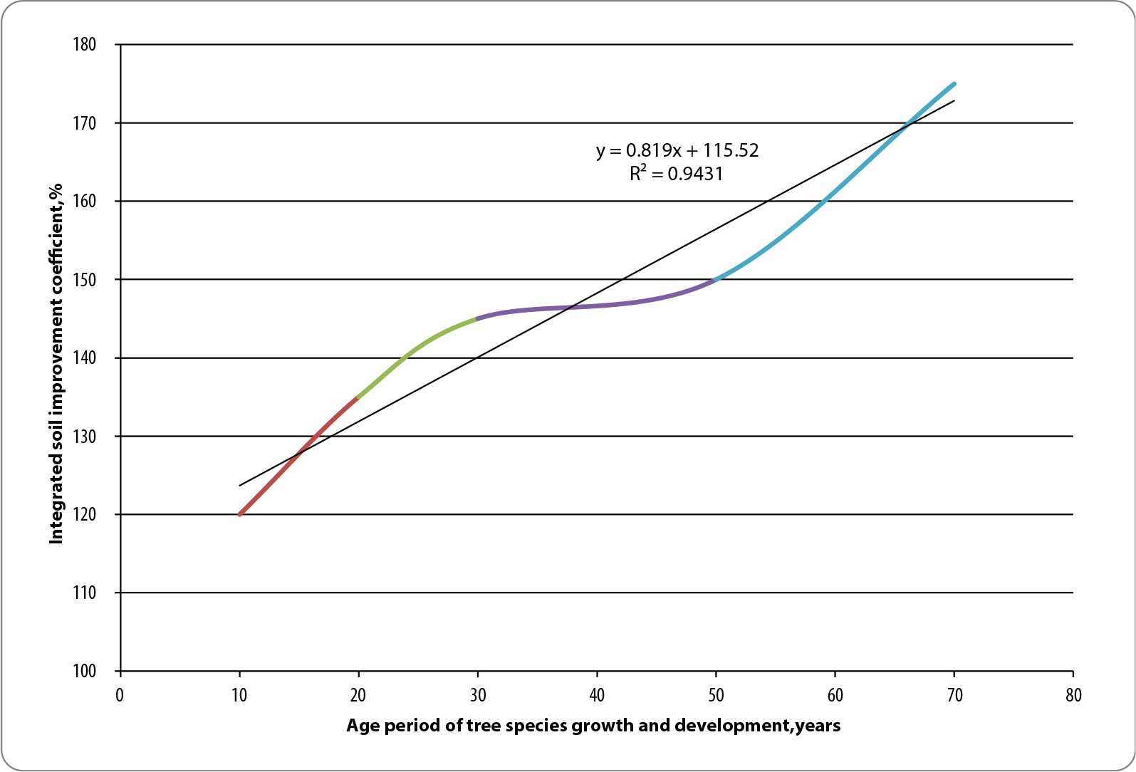
Figure 3.
Trends in integrated soil improvement coefficients as a function of the age periods of growth and development of pine stands
Source: Prepared by the authors
Within the Yampil Forest District of the Zhmerynka Regional Forestry Administration, a branch of the “Central Forest Office” of the State Enterprise “Forests of Ukraine,” comprehensive studies were conducted on pure stands of Crimean pine (Pinus nigra subsp. pallasiana) covering a total area of 25 ha. The forest improvement characteristics of the study sites are summarized and presented in Table 5.
Table 5.
Forest reclamation parameters and edaphic conditions of the Crimean pine research sites within the study area
| No. of the sample plot | Location | Area of the subcompartment, ha | Slope exposure | Slope, degrees | Degree of soil erosion | |
|---|---|---|---|---|---|---|
| forest compartment | forest sub-compartment | |||||
| 1 | 96 | 21 | 0.4 | SE | 25 | moderately eroded soils |
| 2 | 11 | 26 | 0.4 | SW | 15 | slightly eroded soils |
| 3 | 15 | 2 | 3.7 | SE | 25 | moderately eroded soils |
| 4 | 15 | 3 | 1.8 | SW | 25 | slightly eroded soils |
| 5 | 15 | 6 | 7.6 | SW | 25 | slightly eroded soils |
| 6 | 15 | 9 | 0.6 | SW | 25 | moderately eroded soils |
| 7 | 52 | 4 | 0.6 | SE | 10 | slightly eroded soils |
| 8 | 56 | 4 | 0.5 | SW | 11 | slightly eroded soils |
| 9 | 49 | 4 | 6.0 | SW | 20 | slightly eroded soils |
| 10 | 49 | 5 | 1.7 | SW | 5 | slightly eroded soils |
| 11 | 49 | 6 | 1.7 | SW | 20 | slightly eroded soils |
| In total | 25.0 | - | ||||
Analysis of the data presented indicates that the study sites of Crimean pine are predominantly located in slope habitats with southeastern and southwestern exposures and gradients ranging from 5° to 25°, which contributes to the area’s increased susceptibility to erosion. Weakly eroded soils predominate, but some plots are characterized by a moderate degree of erosion, indicating active or potential erosion processes. The areas of the plots vary widely (0.4–7.6 ha), reflecting the spatial heterogeneity of site conditions. It has been established that the formation of the study stands occurs under conditions of complex relief and varying degrees of soil degradation. This circumstance determines the important forest-remediation role of Crimean pine in stabilizing slopes and improving edaphic conditions.
The forest inventory characteristics of the study sites are presented in Table 6.
Table 6.
Silvicultural and assessment characteristics of the study sites of Pinus nigra subsp. pallasiana
| No. of the sample plot | Composition of the stand | Age, years | Average figures | Stand site indexes | Type of site conditions | Stand density, unit | Stock, m3·ha-1 | |
|---|---|---|---|---|---|---|---|---|
| H, m | DBH, cm | |||||||
| 1 | Pinus nigra - 1.0 | 55 | 16.8 | 24.3 | II | C2 | 0.80 | 334 |
| 2 | Pinus nigra - 1.0 | 54 | 14.7 | 20.4 | III | C2 | 0.77 | 258 |
| 3 | Pinus nigra - 1.0 | 43 | 12.6 | 20.5 | III | C1 | 0.68 | 216 |
| 4 | Pinus nigra - 1.0 | 43 | 14.9 | 23.0 | II | C2 | 0.84 | 323 |
| 5 | Pinus nigra - 1.0 | 43 | 15.2 | 24.6 | II | C2 | 0.81 | 314 |
| 6 | Pinus nigra - 1.0 | 43 | 15.5 | 22.8 | II | C2 | 0.88 | 308 |
| 7 | Pinus nigra - 1.0 | 42 | 12.8 | 16.6 | II | C2 | 0.93 | 272 |
| 8 | Pinus nigra - 1.0 | 30 | 10.3 | 14.7 | II | C2 | 0.87 | 174 |
| 9 | Pinus nigra - 1.0 | 36 | 12.9 | 24.3 | II | C1 | 0.78 | 237 |
| 10 | Pinus nigra - 1.0 | 25 | 7.5 | 10.4 | III | C1 | 0.83 | 72 |
| 11 | Pinus nigra - 1.0 | 25 | 7.3 | 10.2 | III | C1 | 0.83 | 77 |
The age of the experimental stands ranges from 25 to 55 years. Average forest mensuration indicators, in particular height (H) and diameter at breast height (DBH), correspond to the age structure of the stands and ensure a level of productivity corresponding to bonitet classes II–III. The stands have developed under dry and fresh sub-forest conditions, reflecting their edaphic and ecological specificity. The stand density ranges from 0.68 to 0.93; in terms of timber productivity, the variation according to age ranges from 72 m3·ha-1 (at 25 years) to 334 m3·ha-1 at 55 years.
The experimental stands at sample plots Nos. 10 and 11 are the youngest, at 25 years old. In this context, sample plot No. 11 was selected as the control plot, against which the indicators were converted into relative values (Tab. 7). Indicators of site class and type of forest growing conditions were not included in the calculations, due to their stability within the study areas.
Table 7.
Silvicultural and mensurational characteristics of the study sites in relative terms, %
| No. of sample plots | Age, years | Midle | Stand density | Stock | |
|---|---|---|---|---|---|
| H, m | DBH, cm | ||||
| 1 | 1.20 | 1.30 | 1.38 | -0.04 | 3.34 |
| 2 | 1.16 | 1.01 | 1.00 | -0.07 | 2.35 |
| 3 | 0.72 | 0.73 | 1.01 | -0.18 | 1.80 |
| 4 | 0.72 | 1.04 | 1.25 | 0.01 | 3.19 |
| 5 | 0.72 | 1.08 | 1.41 | -0.02 | 314 |
| 6 | 0.72 | 1.12 | 1.23 | 0.06 | 3.08 |
| 7 | 0.68 | 0.75 | 0.63 | 0.12 | 2. 08 |
| 8 | 0.20 | 0.41 | 0.44 | 0.05 | 1.26 |
| 9 | 0.44 | 0.77 | 1.38 | -0.06 | 2.08 |
| 10 | 0 | 0.03 | 0.02 | 0 | -0.06 |
The comprehensive assessment of the condition of the stands included indicators of the physical and chemical properties of the soils at the study sites, which have been summarised and presented in Table 8. Analysis of the data obtained indicates an inversely proportional relationship between soil hardness and its water permeability: as hardness increases, water permeability decreases, which is of significant importance in terms of erosion control.
Table 8.
Physicochemical parameters of the soils at the study sites
| No. of sample plots | Humus horizon, cm | Active root surface area, cm2 | Water permeability, mm·min-1 | Soil hardness, kg·cm-2 | Humus, % | MG per 100 g of soil | ||
|---|---|---|---|---|---|---|---|---|
| P2O5 | K2O | nitrogen, which hydrolyses | ||||||
| 1 | 28 | 4853 | 6.2±0.47 | 10.1±1.05 | 1.92 | 1.7 | 19.8 | 9.86 |
| 2 | 27 | 4781 | 5.7±0.23 | 10.7±1.12 | 1.87 | 1.5 | 19.2 | 8.54 |
| 3 | 19 | 3989 | 3.4±0.76 | 11.4±1.21 | 1.30 | 1.3 | 14.9 | 6.57 |
| 4 | 26 | 4354 | 4.5±0.64 | 12.7±1.37 | 1.53 | 1.4 | 17.3 | 7.63 |
| 5 | 28 | 4485 | 4.7±0.82 | 12.8±1.25 | 1.82 | 1.2 | 16.7 | 8.16 |
| 6 | 17 | 4105 | 3.6±0.61 | 13.5±1.43 | 1.36 | 1.0 | 19.0 | 7.41 |
| 7 | 27 | 4420 | 3.0±0.42 | 14.0±1.75 | 1.67 | 0.9 | 18.5 | 7.24 |
| 8 | 25 | 4230 | 2.9±0.46 | 15.2±2.01 | 1.61 | 1.2 | 18.1 | 7.17 |
| 9 | 26 | 3549 | 2.6±0.51 | 16.3±1.07 | 1.43 | 0.9 | 13.0 | 6.98 |
| 10 | 27 | 3420 | 2.3±0.48 | 17.2±1.23 | 1.39 | 0.8 | 11.8 | 6.72 |
| 11 | 28 | 3389 | 2.1±0.52 | 17.5±1.34 | 1.25 | 0.6 | 12.1 | 6.54 |
The absolute values of the parameters under investigation were normalised by converting them into relative values based on the reference plot of sample plot No. 11. The summarised results of the physico-chemical characteristics of the soils, expressed in relative terms, are presented in Table 9.
Table 9.
Comparative analysis of the physico-chemical characteristics of soils in relative terms
| No. of sample plots | Humus horizon, % | Active root surface area, % | Water permeability, % | Soil hardness, kg/cm2 | Humus % | % | ||
|---|---|---|---|---|---|---|---|---|
| P2O5 | K2O | nitrogen that hydrolyses | ||||||
| 1 | 0 | 0.43 | 1.95 | 0.42 | 0.54 | 1.83 | 0.64 | 0.51 |
| 2 | -0.03 | 0.41 | 1.71 | 0.39 | 0.50 | 1.50 | 0.59 | 0.31 |
| 3 | -0.32 | 0.18 | 0.62 | 0.35 | 0.04 | 1.17 | 0.23 | 0.01 |
| 4 | -0.07 | 0.28 | 1.14 | 0.27 | 0.22 | 1.33 | 0.43 | 0.17 |
| 5 | 0 | 0.32 | 1.24 | 0.27 | 0.46 | 1.00 | 0.38 | 0.25 |
| 6 | -0.39 | 0.21 | 0.71 | 0.23 | 0.09 | 0.67 | 0.57 | 0.13 |
| 7 | -0.04 | 0.30 | 0.43 | 0.20 | 0.34 | 0.50 | 0.53 | 0.11 |
| 8 | -0.11 | 0.25 | 0.38 | 0.11 | 0.29 | 1.00 | 0.50 | 0.10 |
| 9 | -0.07 | 0.05 | 0.24 | 0.07 | 1.14 | 0.50 | 0.07 | 0.07 |
| 10 | -0.04 | 0.01 | 0.10 | 0.02 | 0.11 | 0.33 | -0.02 | -0.97 |
In order to determine the effect of soil hardness on its permeability, the corresponding relationship is illustrated in Figure 4.
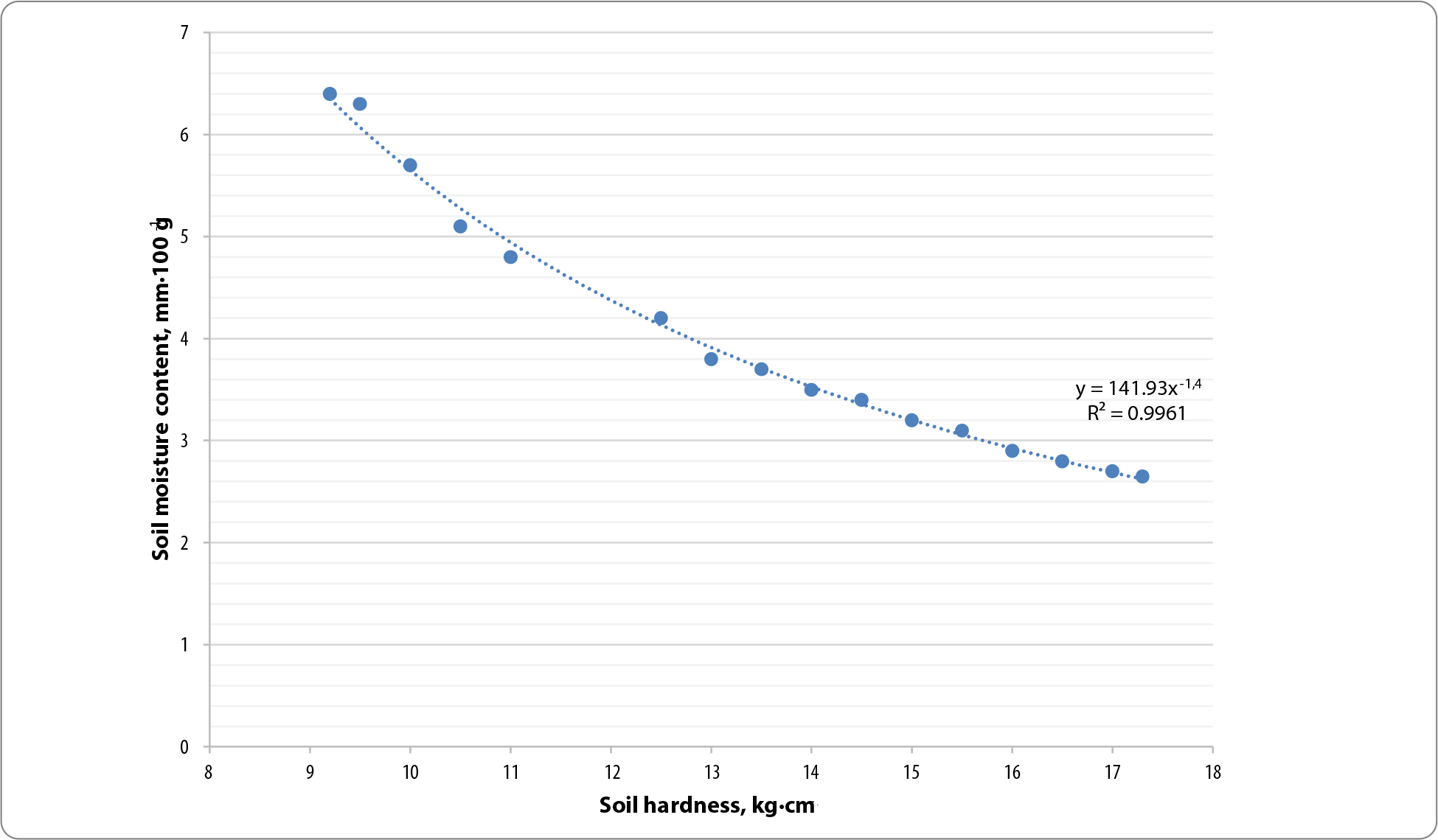
Figure 4.
Relationship between soil permeability and soil hardness
Source: Prepared by the authors
The sign for hardness has been reversed, as a decrease in hardness is beneficial for stands in terms of the development of their root systems. The condition of the stands is determined using the assessment scale (Tab. 10) (Hrik et al. 2024). If the calculations yield lower percentage values for the condition index, this indicates a better quality, safer (healthier) overall condition of the stand. It is particularly important to take this into account in relation to the age of the stands. As a rule, younger stands are significantly healthier, as they have not yet had time to suffer the negative effects of the natural environment, which has been altered by anthropogenic pressure.
Table 10.
Scale for assessing the condition of forest stands
| No. | Comprehensive indicator | Value, % | Condition of the tree stand |
|---|---|---|---|
| 1 | very high | 0–20 | safe |
| 2 | high | 21–40 | weakened |
| 3 | medium | 41–60 | weak |
| 4 | low | 61–80 | very weak |
| 5 | critical | 81–100 | dangerous |
The comprehensive index of the condition of pine stands represents the average of the algebraic sum of all the relative comparative indicators, of which thirteen were used in this particular study.
The results of the calculations of the integrated indicators of the condition of the plantations are presented in Table 11.
Table 11.
Calculation of integrated indicators of the condition of stands
| No. of sample plots | Age | Hm | DBH | SD | S | Hh | ARSA | SP | SH | H | P | K | A | Condition |
|---|---|---|---|---|---|---|---|---|---|---|---|---|---|---|
| 1 | 1.20 | 1.30 | 1.38 | -0.04 | 3.34 | 0 | 0.43 | 1.95 | 0.42 | 0.54 | 1.83 | 0.64 | 0.51 | 1.04 |
| 2 | 1.16 | 1.01 | 1.00 | -0.07 | 2.35 | -0.03 | 0.41 | 1.71 | 0.39 | 0.50 | 1.50 | 0.59 | 0.31 | 0.83 |
| 3 | 0.72 | 0.73 | 1.01 | -0.18 | 1.80 | -0.32 | 0.18 | 0.62 | 0.35 | 0.04 | 1.17 | 0.23 | 0.01 | 0.52 |
| 4 | 0.72 | 1.04 | 1.25 | 0.01 | 3.19 | -0.07 | 0.28 | 1.14 | 0.27 | 0.22 | 1.33 | 0.43 | 0.17 | 0.77 |
| 5 | 0.72 | 1.08 | 1.41 | -0.02 | 3.14 | 0 | 0.32 | 1.24 | 0.27 | 0.46 | 1.00 | 0.38 | 0.25 | 0.79 |
| 6 | 0.72 | 1.12 | 1.23 | 0.06 | 3.08 | -0.39 | 0.21 | 0.71 | 0.23 | 0.09 | 0.67 | 0.57 | 0.13 | 0.65 |
| 7 | 0.68 | 0.75 | 0.63 | 0.12 | 2.08 | -0.04 | 0.30 | 0.43 | 0.20 | 0.34 | 0.50 | 0.53 | 0.11 | 0.51 |
| 8 | 0.20 | 0.41 | 0.44 | 0.05 | 1.26 | -0.11 | 0.25 | 0.38 | 0.11 | 0.29 | 1.00 | 0.50 | 0.10 | 0.38 |
| 9 | 0.44 | 0.77 | 1.38 | -0.06 | 2.08 | -0.07 | 0.05 | 0.24 | 0.07 | 1.14 | 0.50 | 0.07 | 0.07 | 0.51 |
| 10 | 0 | 0.03 | 0.02 | 0 | -0.06 | -0.04 | 0.01 | 0.10 | 0.02 | 0.11 | 0.33 | -0.02 | -0.97 | -0.04 |
[i] Note: Age – age of the stands, %; Hm – average height, %; DBH – average diameter at breast height, %; SD – stand density, %; S – stand stock, %;
[ii] Hh – humus horizon, %; ARSA – active root surface area, %; SP – soil permeability, %; SH – soil hardness, %; H – humus content, %; P – content of available phosphorus, %; K – potassium content, %; A – hydrolysable nitrogen content, %; A – hydrolysable nitrogen content, %; Condition – overall condition rating, %.
All experimental stands of Crimean pine aged between 25 and 55 years are in a safe, and therefore healthy, condition. They all have a stand condition index based on 13 criteria ranging from -0.04 to 1.04, which does not exceed 20% (Hrik et al. 2024). This is an indisputable fact; however, a certain differentiation can be observed in the stand condition index. The numbers of the sample plots are assigned in ascending order according to the condition index as follows: sample plot No. 10 has the lowest value, followed by sample plot No. 8, sample plot No. 7 and 9, sample plot No. 3, sample plot No. 6, sample plot No. 4, sample plot No. 5, sample plot No. 2, sample plot No. 1. Thus, of those listed, sample plot No. 1 has slightly poorer results, with a comprehensive condition assessment index of 1.04 at the age of 55.
Discussion
The results of a comprehensive assessment of the condition of Crimean pine (Pinus nigra subsp. pallasiana) stands on eroded ravine and gully lands in the Right-Bank Forest-Steppe of Ukraine confirmed the effectiveness of the integrated index methodology used and enabled the identification of patterns in the growth, development and soil-improving effects of the stands under study.
An analysis of the silvicultural and mensuration characteristics of the study sites revealed that the Crimean pine stands within the Yampil Forest District are classified as site classes II and III under dry (C1) and fresh mixed broadleaf forests (C2) conditions. The established range of stand volumes – from 72 to 334 m3·ha-1 depending on age (25–55 years) – indicates stable growth and a relatively high level of productivity for eroded soils, which is consistent with data from previous studies (Malûga, 2019; Malyuga and Minder, 2021). The stand density, ranging from 0.68 to 0.93 units, indicates the absence of critical thinning in the stands and the preservation of their coenotic stability even on slopes with gradients of up to 25° under unfavourable edaphic conditions.
A study of the physical and agrochemical properties of soils has revealed an important ecological function of Crimean pine stands: the improvement of the properties of eroded substrates. The established inversely proportional relationship between soil hardness and its water permeability confirms the effectiveness of the erosion control mechanism of the Crimean pine root-soil complex: as the surface area of active roots increases – 3389–4853 cm2 – the soil mass becomes looser, its hardness decreases from 17.5 to 10.1 kg/cm2, and its water permeability increases from 2.1 to 6.2 mm·min-1. Similar patterns for erosion control stands of various tree species have been documented in (Mìnder et al. 2019; Rashad et al. 2026).
The observed trends in the integral soil improvement coefficients (120–180 % over a 7–70-year age range) are described by a linear regression model with a high coefficient of determination (R2 = 0.91), which allows the edaphic effect of plantations to be predicted with sufficient accuracy as they age. The results obtained are fundamentally consistent with the conceptual principles of the phased ecological restoration of eroded areas under the influence of tree stands (Malyuga and Minder 2021; Rashad et al. 2026) and confirm the validity of distinguishing the age-related stages of the ameliorative effect of tree stands, as proposed by the authors (Malûga 2020).
The application of the methodology for determining the integrated condition index of forest stands (Hrik et al. 2024) enabled a comprehensive comparison of the study sites across 13 diverse indicators. All 10 study plots received an integrated condition index ranging from −0.04 to 1.04, which corresponds to the “safe condition”) category (0–20%) on the accepted scale. This confirms that even under conditions of complex terrain and significant soil degradation, the Crimean pine forms stands that are stable in terms of sanitary and silvicultural condition. This conclusion correlates with the results of studies in the Podolian Transnistria region (Ol′hovs′kij 2002), where the survival rate of Pinus nigra subsp. pallasiana on stony substrates with a closed root system was 74–96%.
At the same time, the observed differences between the study plots in terms of the integral condition index are a methodologically significant finding. The sample plot No. 10 (a 25-year-old stand) has the lowest index (−0.04), indicating that it is in the best relative condition. In contrast, sample plot No. 1 (55-year-old stand) has the highest index (1.04), reflecting a trend of deterioration from the reference condition with increasing age. This is entirely natural, as younger stands demonstrate higher physiological activity, lower levels of natural mortality, and have not yet been fully exposed to the effects of abiotic and biotic stress factors. A similar age-related differentiation in the sanitary and functional condition of artificial stands has been documented in studies of forest reclamation plantations in Ukraine (Malûga 2020; Mìnder et al. 2019).
A spatial analysis of the study sites revealed that plots situated on south-eastern and south-western facing slopes with a gradient of 20–25° are characterised by slightly lower values of water permeability and humus content compared to plots on slopes with a gradient of 5–15°. This confirms the dominant influence of the geomorphological factor on the transformation of soil properties under the canopy of stands and is consistent with previously established patterns for similar ecotopes (Malûga et al. 2023; Ol′hovs′kij 2002).
The proven effectiveness of the method for comprehensively assessing the condition of stands using an integrated index is of particular scientific value. The conversion of diverse absolute values of indicators – silvicultural, physical and agrochemical – into a generalised relative scale through comparison with a control site eliminates the problem of the heterogeneity of the source data and ensures objective differentiation between stands with similar absolute characteristics. This approach can be widely applied in the monitoring of protective forest stands for various purposes in the Forest-Steppe and Steppe regions of Ukraine.
Conclusions
The erosion control stands established by the Yampil Forestry Enterprise (now the Yampil Forest District) play a key role in stabilising the eroded lands of Podillia and curbing the progression of erosion processes. The stands of Crimean pine (Pinus nigra subsp. pallasiana), established in ravine and ravine-valley areas, are characterised by stable growth under challenging edaphic conditions (stand site indexes – II–III, C1–C2), with timber stock increasing from 72 to 334 m3-·ha-1 at the age of 25–55 years.
It has been established that, during the formation of the forest environment (7–70 years), there is a significant improvement in soil properties: the integral soil improvement coefficient increases from 120 to 180 % (R2 = 0.91), indicating the gradual restoration of degraded soils. One of the key factors is the development of root systems (3389–4853 cm2), which contribute to soil loosening and increased water permeability. An inversely proportional relationship has been established between soil hardness and permeability: as hardness increases (10.1–17.5 kg·cm-2), permeability decreases (6.2–2.1 mm·min-1).
A comprehensive assessment of the condition of the stands using an integrated index (based on 13 parameters) showed that all study plots are within the safe condition range (<20%), whilst differences were observed depending on age and growing conditions: younger stands are in the best condition, whereas older stands show a tendency towards deterioration.
The integrated assessment method employed has proven effective for monitoring afforestation projects, as it takes a comprehensive account of silvicultural, physical and agrochemical indicators and can be recommended for practical application in the Forest-Steppe and Steppe regions of Ukraine.