
Foreign men, do you think
Do you think about the waters rising?
——“More than Just a Blue Passport,” Selina Neirok Leem1
In a speech about the legacy of nuclear testing and climate change in the Marshall Islands, Marshallese climate activist and poet, Selina Neirok Leem, presented two photographs on the slideshow.2 One has a waste dump in the background, towering over the group of people standing in the front. The other shows a seemingly unremarkable bridge, with a small boat trying to cross under. According to Leem, only four meters above sea level, the bridge is the highest point of her hometown, Majuro Atoll, the capital city of the Marshall Islands. Meanwhile, as of 2017, the dump site nicknamed Mt. Majuro, has reached a height of 55 meters.3 If the sea level rises above four meters, the bridge is the only place people can seek refuge while the waste dump will be carried away, scattered across the ocean. As Leem described these photographs, she was not just presenting a dire situation, but performing a cartography of climate change that weaved together Majuro’s landscapes and the visceral experience of sea level rise, which ceased to be a number, but a measurement that could be seen and felt.
With 29 low-lying atolls, the Marshall Islands are extremely vulnerable to climate change, as the rising waters threaten to submerge the atolls.4 When waves rush towards the shore, what often happens is not the totalizing, apocalyptic sweeping away of the entire atoll. Rather, destruction happens at the level of everyday livelihoods. Sea level rise is translated to salt water flushing into freshwater aquifers used for drinking and cooking; it means bleached corals, eroded reefs, and decreasing fish populations—the source of sustenance and income.5 With warmer temperatures and frequent floods, sea level rise increases waterborne diseases, affecting the local communities’ well-being, forcing Marshallese to leave their homeland and become climate refugees.6
These place-based lived experiences and ecological impacts illustrate the spatial relationships Marshallese have with the environment, which have been transformed as sea level rise becomes an everyday reality. These intricate relationships are rarely represented in climate change maps that scientists show to convince people that “global climate change is real.”7 Labeled as scientific and objective, popular maps often exist as unquestionable depictions of climate reality. Only representing one way of mapping, these maps’ weight and ubiquity impose spacial relations that produce boundaries and turn fluctuating contingencies abstract.8 This spatial fixity, is “commensurate with hegemonic conceptualizations of territorial and property relationships,” making these power-laden maps appear “inevitable” and “common-sensical.”9
Theorizing with poetic cartographies from and about the Marshall Islands, this paper problematizes the dominant cartographic visualization of climate change, which often adopts a settler-colonial imaginary of the globe and appears to be scientific through datafication. I argue that this mainstream cartography of climate change cultivates exploitative and extractive relationships with the environment, meanwhile critical Indigenous articulations of sea level rise emphasize the ethics of cohabitation, perpetuating kinship and reciprocity with the ocean. Specifically, settler-colonial and scientific cartography makes the existence of small islands invisible, turns lived realities into flattened, quantified abstractions through data visualization, and projects climate struggles to the future and elsewhere, producing hypervisible island paradises. Weaving my analyses with poetry by Kathy Jetñil-Kijiner and Selina Neirok Leem, a photography workshop by Joy Lehuanani Enomoto, and other visual representations, I foreground relational and genealogical connections in critical cartographies informed by Indigenous poetics of climate change. These poetic expressions demonstrate a relational approach to space, substantiate climate change through place-based stories and experiences in contrast with the homogenizing global scale; temporally, they highlight the fluctuating dynamics of climate change as everyday catastrophes while grounding commitments to protect the environment through ancestral memories and knowledge of abundance. Regarding sea level rise, as many Indigenous creation stories from the Pacific start from the birth of the ocean, these critical cartographies recognize the ocean as an active life-giving force, account for its volumetric materiality, and articulate climate change as part of everyday life with the ocean rather than a one-time crisis that positions human against the ocean. Climate change then becomes a problem of cohabitation with the more-than-human rather than scientific knowledge.
How climate change is approached partly depends upon how the environment is cartographically visualized. Far from simply reflecting “reality,” cartography is a political technology, with the power to structure relationships and emotions, which determine how spaces are organized and experienced.10 Since the inception of modern cartography, maps have been categorized as “scientific” imagery, and also are a political force in society, working to produce knowledge and shape political systems.11 More specifically, identifying maps as “the weapons of imperialism,” geographer John Brian Harley points out their role in colonial promotion, noting that “maps anticipated empire.”12 Similarly, Jordan Branch traces the history of modern statehood to “linear boundaries between homogenous territories,” which actively created and secured exclusive territorial claims of sovereign states, a border-making system that displaces communities and provokes conflicts.13 As charted geometrical lines ignore Indigenous people and turn land into territory, in the Pacific, colonial cartography also creates racial categories and hierarchies that “continue to haunt the novel, often anomalous political borders that were negotiated by colonial states, [and] inherited by postcolonial ones.”14 The reality-making power of modern cartography and the violence associated with it make it necessary to scrutinize how colonial, statist, and racist geographical imaginary structures people’s perception of the spaces it represents.
The significance of looking at Indigenous cartography and poetic expressions lies in cultivating alternative relationships with the environment that are dynamic and relational. In Candace Fujikane’s analysis of Kanaka Maoli (Native Hawaiian) cartographies, she contrasts moʻolelo (stories) with the two-dimensional maps that perceive space as static, extractable resources instead of storied landscapes and intimate kin.15 With this settler-colonial and scientific perspective taking over people’s imaginary, a proper response to climate change relies on Indigenous and decolonial cartographies which are “spatial practices of world-making.”16 Perpetuated by “Indigenous relationships and responsibilities to land,” critical cartographies facilitate different modes of engagement with the environment.17 According to Fujikane, critical cartographies that are based on the practices of ea (land, life, and sovereignty), foster “intimate relationships with ‘āina (lands and waters which feed) in ways necessary to our planetary future.”18 This relational approach to the environment is echoed by Yacaaʔał George and Sarah Marie Wiebe’s discussion of seascape relationality, which “challenges extractivist, neoliberal settler colonial governmentality” that control and dispossess Indigenous lives through diffuse systems of environmental governance.19 With neoliberal enclosures of commons such as the ocean, the environment is reduced to manageable and extractable natural resources that become private or state-owned property, preventing Indigenous communities’ dynamic engagement with the environment. Seascape relationality, on the other hand, “invites humans into an emergent and reciprocal dance with more-than-human lifeworlds.”20 The ocean is both a site of struggle and is productive of new relations. Sea level rise is thus in urgent need of critical cartographies to perpetuate such intimate and responsible relationships through seascape relationality.
For many Indigenous Pacific communities, intimacy and relationality with the environment is an expression of genealogical relationships. While genealogy is generally understood as familial lineages, more recently, its theoretical and methodological significance is increasingly highlighted in Indigenous scholarship.21 Indigenous genealogies reflect conceptualizations of space-time. For Kanaka Maoli, for example, genealogy is “an unbroken chain that links those alive today to the primeval life forces—to the mana (spiritual power) that first emerged with the beginning of the world,” from which answers to future challenges can be found.22 This dynamic connection of the past, present, and future sees creation stories not as fictional legends from the past, but as cosmological foundations that sustain the continuation of people and culture. “Primeval life forces” are physically manifested in the current environment, where land and waters are recognized as ancestors and kin, passing down multigenerational place-based knowledge and memories. Genealogical relations with the environment have diverse expressions and are particular to specific places and Indigenous communities. These relationships require constant engagement and poetic attunement to the environment’s stories, memories, and desires. In Marshallese language, for example, the word bwij (lineage group) derives from bwijen (the navel or umbilical cord), which is linked to bwidej (land), reflecting how “concepts of mothers, food, life, lineage, and land are symbolically and inextricably linked.”23 As such, Indigenous cartography is not just a counter representation to settler-colonial cartographic articulations, but works to reorient our spatial and temporal relationship with the environment and to politicize climate challenges.
The Disappearance of Oceania in Colonial Global Imaginary
Maps of global climate change appear to be pages from coloring books: the map maker could paint the map with different colors, but the contours of the world is predetermined. From scientific agencies to mainstream media, climate change is often presented with the same two-dimensional projection of the globe.24 Usually, the north pole is at the top, while Antarctica sits at the bottom, with Europe and Africa in the middle, towards which the other five continents gravitate. This global vision centers on landmasses, while the ocean exists as a negative space, receding in the background. The Pacific is abruptly cut into two parts, lying at the periphery on both sides, instead of a connected whole where people share languages, cultures, voyaging histories, and colonial violence. This Eurocentric and colonial perspective is the dominant geographic imaginary that many people rely on to orient themselves and gain awareness of the range and the locations of climate change.
The preoccupation with landmasses in mapping reflects an obsession with the “greatness” of territorial size, along with resourcefulness, productivity, and political dominance. Expected to be objective and accurate, the cartographer must be consistent with the scale of the map, which privileges greater-sized lands. The Marshall Islands are submerged by the overwhelming blue ocean, and are rendered invisible on most global maps. Therefore, when the impacts of climate change are illustrated, they are “invisible” in the “empty” Oceania. The smallness of the Marshall Islands is thus manifested as a non-existence, a physical absence of land (in print, on the screen, in people’s imagination) that cannot be encountered with our eyes.
The erasure of islands and atolls across Oceania reflects an economic conceptualization of the ocean, or what George and Wiebe succinctly term “landlocked property-centric territorial geographies,” where the ocean is an “instrumental site of commodification.”25 Different from Epeli Hau‘ofa’s vision of a “sea of islands” with deep entanglements, Oceania is often reduced to the “Pacific Rim.” Both a geographical depiction and a political discourse, this expression exemplifies the neoliberal prospect of free trade epitomized by the flow of water in the Pacific region that simulates the flow of capital.26 Based on this analysis, Margaret Jolly further argues that the hegemonic discourse occludes what is “inside” the rim, depicting the Pacific as “a lack, a hole, like the proverbial hole in the donut…And those who live in the Pacific, the Islanders, are not imagined as part of that sphere.”27 This perception of the empty “inside” of the Pacific Rim is echoed by Australia’s characterization of the Pacific region, whose failure in economic development is read as the possibility of “falling off the map” in the global imagination.28
The representation of global climate change and the consequent disappearing of small islands in Oceania are made possible by the modern age of colonization, which Martin Heidegger characterizes as “the Age of the World View.”29 The bird’s-eye view assumes that a single position from the top is sufficient to see the complexity of the whole world. As Jairus Victor Grove explains, Eurocentrism is “a five-hundred-year project of violent terraforming and atmospheric engineering,” which “flattened places into dedifferentiated spaces,” both materially and representationally.30 As a result, “[t]he planet became the map” on which climate change and planetary crisis today are projected.31 The global map, at the visual register, reflects what Grove calls the geopolitical project of the planet Earth, eliminating non-European forms of life (and hence the “local” small islands) to make the global imaginary possible.32 As such, people who inhabit these invisible and atemporal spaces are perceived as forms of life destined to disappear.
The settler-colonial map of global climate change expresses a desire to not only see the globe from above, but also to see it as a smooth and flat sphere that invisibilize specificities of different localities. This global scale and the assumption that localities are scalable homogenize different climate change stories across spaces, dismissing the plurality and specificity of environmental experiences.33 Since the Marshall Islands are invisible and rendered insignificant on the global maps, Marshallese’s voices are trapped in the middle of the Pacific, unable to “scale up” to tell their climate change stories to the world. Unlike generalizable European experiences, when they are made legible, the Marshall Islands’ particularities are over-emphasized, where the disappearing islands are narrated as exceptional cases that simply detach themselves from the global condition.34
Rising Sea Level at Relational Localities
What does it mean to the world if the Marshall Islands are made to disappear by sea level rise? As analyzed above, with settler-colonial bird’s-eye view and global-local binary, climate change maps often conceal the entanglements between the Marshall Islands and the globe, presenting the islands as non-existing or a space of exception disconnected from the rest of the world. Contrarily, in “The Butterfly Thief,” Marshallese poet and climate activist Kathy Jetñil-Kijiner writes: “…if our islands drown out/due to the rising sea level/just who do you think/will be next//I’m taking you with me.”35 The last line, repeated five times throughout the poem, highlights the relationality between “you” (people unaware of sea level rise) and “me” (Jetñil-Kijiner and others facing climate change first-hand), and how “the rest of the world” is deeply implicated in the fate of the Marshall Islands.
Unsatisfied with a single world map, in Water: An Atlas, scholar and environmental journalist Christina Gerhardt and Emily Busch de-center the continents and map the rising sea levels at the Majuro Atoll by 2055.36 This image includes various components: the main map of Majuro Atoll, which takes up most of the space; in the upper left corner, the small world map centering the Pacific Ocean with the location of the Marshall Islands marked out by a square; the map at the upper right corner zooms into the Marshall Islands chains; some dash-lines trace the resettlement route (from Bikini to Rongerik to Kili) of Bikinians after United State’s largest nuclear detonation of Castle Bravo on March 1, 1954 at Bikini Atoll.37 Between the maps, two short paragraphs summarize the geographical and historical information of the Marshall Islands, with an emphasis on sea level rise in Majuro.
Gerhardt and Busch’s map begins by giving context to people who are not familiar with the region. For example, they situate sea level rise-related evacuation of Marshallese within the history of the U.S.’s detonation of twenty-three nuclear bombs on Bikini; they also give basic information such as “the Marshall Islands sit less than six feet above sea level.”38 The three maps orient the viewer to see Majuro as embedded in the world, instead of a place “in the middle of nowhere.” While Majuro here is mapped from the top, just as most climate change maps, the “empty” landmass is complemented by photographs taken at specific sites of the atoll. For example, the freshwater aquifer and the drinking supply wells are identified on the left side of the image. A photograph of flooding is attached, reflecting the actual effects of sea level rise—that the rising tides contaminate the Laura groundwater lens which holds 60% of Majuro’s freshwater. Similarly, a photograph with the description of “Homes at risk on Ejit” shows the actual landscape that corresponds to the abstract contour of the shoreline. Through this multi-perspective visualization, the Marshall Islands gain geographical situatedness, while the initially abstract map connects the phrase “sea level rise” to its substantial effects such as the scarcity of freshwater, salinization, and the drowning of atolls—all of which cannot be seen on a regular global map.
As Gerhardt and Busch’s map makes visible climate change in the Marshall Islands by re-connecting the local and the global, others have sought to emphasize the relationality between spaces and how impacts of climate change transcend local boundaries. In the opening artist talk of the exhibition, “Inundation: Art and Climate Change in the Pacific,” Mary Babcock, an artist from the continental U.S., discusses popular maps of the Pacific region: “[regular maps] are not necessarily maps about the lands. They are maps about economics.”39 In addition to how the Pacific is rendered “empty” due to its small scale and “failing” island economies, Babcock is referring to how the mainstream discourse of sea level rise is often translated to economic concerns, overlooking histories of colonialism and disruption of ecologies.40 That is, the severity of climate change is often measured primarily in economic terms, framing the urgency of climate change as a cost-benefit analysis, rather than a matter of survival.
To visualize the tension between the economic-focused approach and “maps about the lands,” in Lotic Sea, Babcock hand-stitches black lines that outline the Exclusive Economic Zones (EEZs) in the Pacific on top of fragile wax papers, which simulate uncontainable waves and glaciers (Figure 1).41 Extending two hundred nautical miles offshore and determining coastal countries’ jurisdiction over resources within the boundaries, EEZs are essential as their boundaries protect Pacific Island countries’ fishing and mining rights.42 The islands imprinted by pin-pricked holes are hardly visible in comparison to the black lines and appear to be displaced, “slipp[ing] or flow[ing] outside of the geopolitical boundaries” of the EEZs.43 The rising sea level, however, makes this seemingly fixed demarcation precarious, as disappearing islands could result in shrinking EEZs, threatening claim to marine resources which would slip into international waters. In that case, disappearing “islands” become “rocks,” which “cannot sustain human habitation or economic life of their own” in U.N. terminologies.44 Under that framing, Indigenous people would have to leave or are doomed to disappear, echoing the racist, colonial trope of the “disappearing native.”45 Island countries are again at a disadvantage due to the privileging of landmasses.
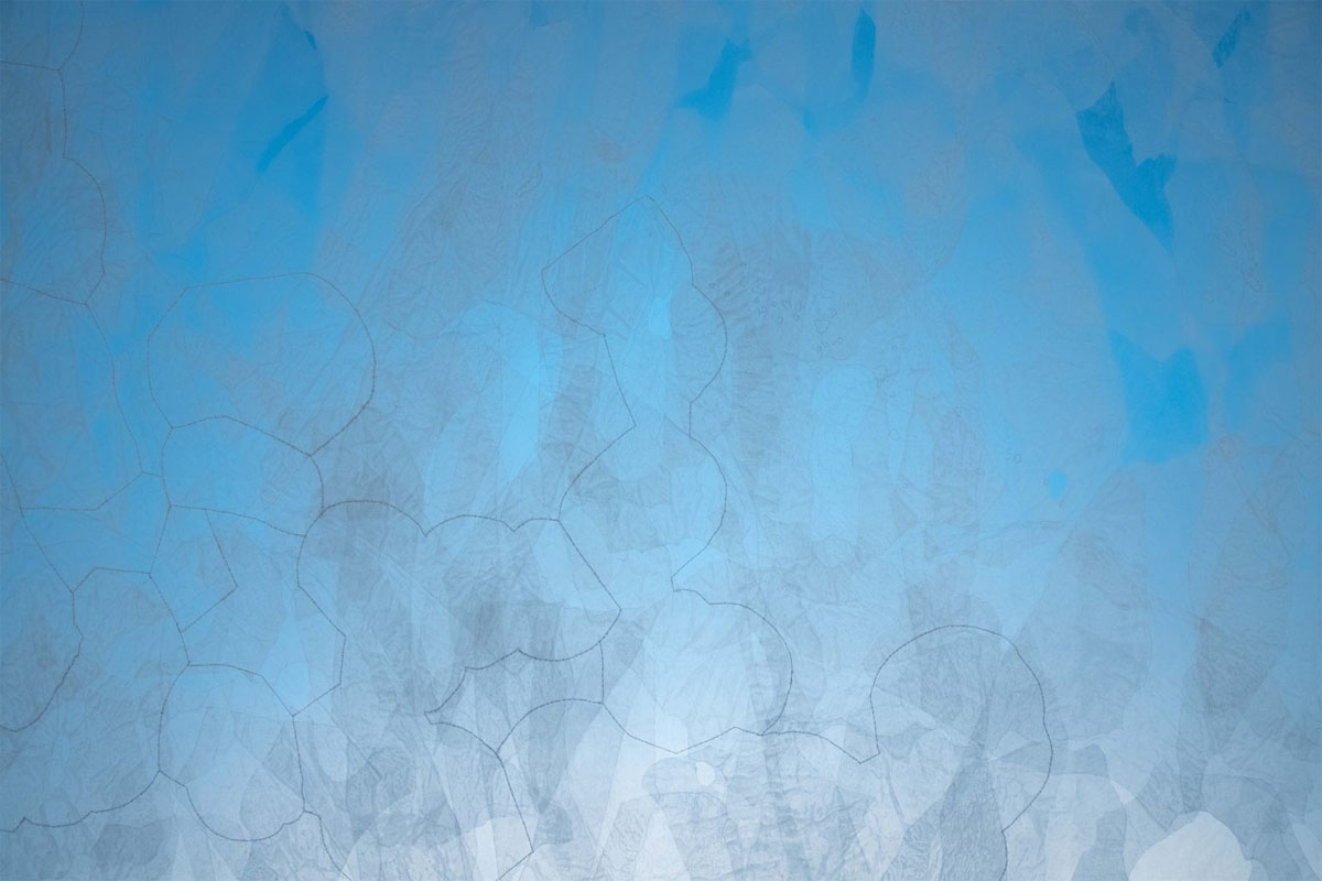
Figure 1
Lotic Sea (detail), the black line is emulating demarcation of EEZs, by Mary Babcock (Artist), photography by Kelly Ciurej.
https://kellyciurej.com/commercial/portfolio-documentation/.
While there are continuous efforts to make current charting of EEZs permanent, the arbitrary nature of the EEZs displaces the islands geographies lurking in the background—as visualized in Babcock’s piece. The EEZs’ lines divide the vast fluid ocean with rigid, geometric lines, dictating the jurisdiction of common marine resources with statist boundaries. Here, the ocean’s visibility and legibility are only possible as the provider of natural resources and as governed by territorial sovereignty. This boundary-making mapping disregards, for instance, that tuna could swim across different EEZs and that these arbitrary lines cannot contain the impacts and solutions of sea level rise. To reflect the flow of water, Babcock uses laminated wax papers to show water overflowing the black lines in various shapes, exceeding economic boundaries. In the gallery, as the luminous blue light is turned on beneath the paper, the waters flow into the exhibition space. Sea level rise is no longer a two-dimensional projection of economic impacts, but uncontainable volumes of water moving through the wall and spreading along the floor, confronting and inundating the viewer standing in front of this Lotic Sea.
The popularity of the global map seems to suggest that it is only by declaring that climate change is global that some of us can accept it as real and vital, despite the fact that many communities around the world have addressed environmental disruptions for centuries.46 Otherwise, environmental concerns remain issues of “elsewhere.” However, the map’s failure in communicating Indigenous people’s experience reflects the limitation, if not violence, of thinking through the global scale and the global-local binary. The critique of global maps urges us to grasp the severity of climate change and how people in different parts of the world are implicated in it without seeing it as global. Contrarily, both Gerhardt and Busch’s map of sea level rise at Majuro and Babcock’s Lotic Sea render space as relational, where small islands and “the rest of the world” are connected in horizontal, rhizomatic, rippling ways.47 That is, “local” climate issues have “global” effects, too. So when the sea level rises, bodies of water disregard territorial and economic boundaries on settler-colonial maps. The end of the world arrives not because climate change has finally become global, but because even the drowning of a single atoll will inevitably take what is in relation to it underwater—just imagine a drowning person dragging another into the ocean. For that matter, “global” climate change is always already “local,” starting from a tiny atoll made invisible on the map.
Datafication of Sea Level Rise, and Everyday Catastrophes
Speaking to her “friends in the [United] [S]tates,” Jetñil-Kijiner addresses popular impressions of the Marshall Islands, including sea level rise: “Tell them we don’t know/of the politics/or the science/but tell them we see/what is in our own backyard.”48 The backyard not only represents the “local” within the global; its concreteness as a three-dimensional space also contrasts with the “scientific” appearance of climate change maps, where numbers and colors replace (the loss of) different forms of life and become the center of the picture. If the bird’s-eye view determines the contour of climate change maps, cartographic abstraction is aided by datafication, a process that quantifies lives into data, which is often used for predictive analysis.49 Specifically, to present data visually, datafication in mapping technology turns the physical environment into thin layers of colors and presents the temporality of climate change in a linear, gradualist fashion, mediating our sense of climate change as statistical reality in the imminent future that never arrives.
The scientific component of cartography has been integral to the modern imagination of the globe (as discussed above). Though appearing objective and indifferent to political power, the historical development of techniques for cartographic precision and detail reinforced expertise. Harley writes, “precise measurement intensified [symbolic power]. Accuracy became a new talisman of authority.”50 This obsession with numbers and measurement restricts institutional efforts in climate change adaptation and mitigation, where achieving environmental goals become a technical and mathematical problem.51 In this day and age of datafication and data visualization, the aesthetics of scientific climate change maps curate a matter-of-fact understanding of the environment through numbers, whose measurements are generalizable as they are visualized on the global map’s flat, static, and homogenized surface. More “qualitative” causes and impacts of climate change in different localities are dismissed, including historical violence of colonization and militarization, allowing colonial agents to shy away from their political responsibility to climate change while continue to act as decision makers on environmental issues.52 Different from an ecological and relational understanding of the environment, climate science data often separates land and ocean by compartmentalizing interconnected phenomena into independent variables or stand-alone resources. This separation fails to reflect how, for instance, sea level rise and surface temperature influence each other, as well as how the landscape is shaped by the ocean physically. In typical sea level change maps, different hues of colors fill out the ocean, indicating different levels of change over the years.53 Condensing the physical volume of water and decade-long changes into one two-dimensional map, both the ocean and the landmasses appear static and unchanged over time, as if the surging waters stop at the very verge of land. Meanwhile, the impacts of sea level rise on land—such as bleached reefs that produce less food or king tides displacing more than 1,000 people from their homes—are invisible in this representation. In fact, nothing but color-coded data is visible, rendering sea level rise as a natural and inevitable climatic progression with no human actors involved. It consequently undermines the history of colonization and capitalism, including extractive activities, construction of military bases, and nuclear weapon testing—all of which have devastated the environment overtime.
As climate science data compartmentalize environmental changes and reduce climate change impacts to a thin layer of colors, it also enables predictive analysis and represents sea level change through future projection as shades of blue gradually encompass the shore. Though experienced as extreme weather and flooding, sea level rise is a subtle change to visualize from the bird’s-eye view. Hence, coastline cartographers often have to dramatize the potential effects of sea level rise to make them salient.54 One way is by imagining a catastrophic future, for example, when all ice caps melt.55 Though this scenario is possible, it is an abrupt leap from the ongoing struggle many small island communities are undergoing, as if climate catastrophe only exists at “the (future) end of the world,” a worldly imaginary that excludes Indigenous people, and a future in which the “natives” had already disappeared as the inferior race. The future is thus cast as a cautionary tale, keeping a safe distance from the immediate present. Hence, this linear, gradualist understanding of sea level rise’s “development” is often communicated without acknowledging the regular and dire situations such as high tides and flooding at the moment. The temporality of climate catastrophe as always-in-the-future dismisses the struggle Marshallese are enduring as if they are in another time-space. Therefore, as the major way to make climate change maps appear “scientific”, datafication of sea level rise quantifies personal experiences and the ocean, which is experienced as “sea level” in numerical terms, limiting the temporality of environmental change to future-oriented and apocalyptic progression which disregards violent pasts and urgent presents.
While many Indigenous cartographers and scientists also creatively utilize technologies like Graphic Information Systems (GIS) to understand island geographies and tell stories of Indigenous spaces, scientific data cannot replace day-to-day embodied encounters with sea level rise.56 Moreover, Indigenous creation stories and genealogies foster a deeper relationship between human and place. Unlike capitalist relations of resource extraction and exploitation, human and the land are in “mutual possession” in Pacific communities, where the environment is often regarded as ancestors or deities.57 Therefore, climate change phenomena are not received as empiricist scientific observations but as “environmental cues” communicated by ancestors and gods, an understanding that unsettles modern approaches to scientific knowledge.58 The corporeal and genealogical imbrication between the two also mean that instances of environmental devastation “not only [scar] [Pacific] lands and waters, but [Pacific Islanders’] bodies and memories as well.”59 The socio-ecological entanglements, multigenerational, visceral experience, and intense materiality of the surging water can hardly be captured by scientific terms like “sea level rise” or “global warming.”
Different from the thin layer of colors on climate change maps, the ocean is “indisputably voluminous, stubbornly material, and unmistakably undergoing continual reformation.”60 To acknowledge the sheer volume of the rising waves and everyday fluctuations of the ocean, Marshallese situate sea level rise in sites where land and ocean converge, or the “shoal”, which Tiffany Lethobo King theorized as “liminal, indeterminate, and hard to map.”61 Witnessing everyday encounters, the seawall is one site that many poets and artists use to map the dynamic encounters of land, ocean, and people. Living on atolls, the Marshallese have an intimate relationship with the ocean, seeing it not as a threat, but as the source of life and the site for ancestral knowledge including surfing, navigation, and fishing. Seasonal inundation and king tides had been regular, anticipated parts of life on the Marshall Islands, and so has seawall-building.62 However, climate change brings high tides in seasons when inundation should not have happened, disrupting centuries-old cycles and ancestral knowledge of the place.63 Selina Leem describes the daily destruction of seawalls in a speech: “We have watched our houses and seawalls that we had just put up again the day before crashed into and crumpled down almost hopelessly onto a shore no longer crawling with crabs but awashed by angry waves.”64 The tides that break through the seawalls rush into homes, unearthing the bones of ancestors buried in backyards.65
The daily labor of rebuilding and repairing the seawalls encapsulates the lived reality of sea level rise for the Marshallese. Rising sea level is part of everyday life. It appears less dramatic than the apocalyptic cartographic visualization, but it is no less devastating. In “More than Just a Blue Passport,” Leem opens the poem by describing the crushing waves on the seawalls in her backyard:
My backyard is
A four-meter history
of waves crashing and breaking
sea-walls built with uncles’, brothers’, and grandpa’s sweat
that one great wall
two meters high
my family’s only protection from the water
made a mockery
as the water has risen
level with the land
and spilled over human debris weaving
a remnant
a reminder
of human being’s greediness66
Connecting the ocean and the backyard, the seawall here is a site of violent encounters between the past and the present, the land and the ocean—where the unpredictable shoals take place, always in motion. “Built with uncles’, brothers’, and grandpa’s sweat,” the “two meters high” great seawall embodies incessant daily labor, which appears simultaneously futile and essential. It is sea level rise mapped by rocks and mud, sweat and labor of Marshallese, resisting the thin, fine line of the predicted area of submersion on scientific maps. Marshallese refuse to let the sea level just “level up,” or wait for the future coastline to approach their homes; instead, people participate in daily struggles of building and rebuilding homes, life, and communities. The labor of rebuilding seawalls illustrates how the temporality of sea level rise is not only about gradual changes overtime, but a daily encounter with the ocean and loss.
It is important to point out that the stone-made seawall built by Leem’s household is different from concrete seawalls which are more widely implemented to fend off the rising sea more permanently. Concrete seawall projects, like the ones funded by the Marshall Islands’ national budget, however, are generally known to be more expensive and more destructive to the environment.67 Known for its “poor ecological performance,” the production of concrete contributes to carbon emission while concrete infrastructures by coastal areas like seawalls disrupt marine biodiversity.68 Such technologies of “shoreline hardening,” as Judy Rohrer analyzes the concrete seawall that guards former U.S. president Barack Obama’s Waimālano property in Hawaiʻi, “epitomiz[e] a domineering, oppositional, and fearful colonial approach to the natural world.”69 Contrarily, Indigenous technologies such as rock-enclosed fishponds called loko kuapā in Hawaiian society “worked with, not against the ocean,” making use of tidal patterns to cultivate fish.70 Leem’s writing also reminds us that water overflowing the seawall is “a remnant/a reminder/of human being’s greediness,” pushing people to think about what and who should be accountable for this daily catastrophe of seawall destruction.71 Though data and distance make some continental states’ contributions to climate change invisible in scientific maps, the materiality of the seawall and the labor that goes into building it are undeniable. It is not the waves that need to be mapped. Rather, it is the system and relations of global economic production, particularly the aspects which produces carbon dioxide which are key causes of global warming that need to be mapped. In addition, the U.S. military is one of the largest single institutional emitters of carbon dioxide globally, outranking many sovereign states.72 Here, the seawall, standing in stark contrast with the statist organization of space, reveal how local communities from the Pacific are bearing the burden of climate change disproportionately.
If the previous section illustrates relationality by presenting the transnational scale of the rising sea level, the human-ocean relationships manifested in the backyards of Marshallese’ homes directs our attention to the local community and Marshallese’s genealogical connection to place. Notably, the rising water not only disrupts the daily lives of Leem’s household, but also the “human debris” in the backyard, where ancestral remains ground kinship between Marshallese and the environment, which is both the place for shelters and a storied landscape.73 This connection fuses environmental destruction with injury to family; meanwhile, leaving the islands behind means abruptly cutting off lineages, feeling “the rupture of having to abandon their ancestral lands.”74 This explains some Marshallese’s resistance towards climate-induced relocation, as these measures erase people’s ties to specific places. the backyard means “more than just a blue passport,” which while it might grant citizenship, legal rights, and sovereignty, cannot replace connections to home. As a physical structure, the seawall in the backyard thus acts as a claim to the land, and as a constantly shifting yet pertinent connection to home.
Impossible Cartographies: Paradise or the End of the World
Cartography is a matter of visibility and visuality, which are not identical.75 While visibility alone does not guarantee political significance and justice, visuality goes beyond what or who is visible and reflects on how are the meanings and values of certain images constructed.76 The problem at stake is not so much whether the Marshall Islands are visible, but the aesthetic and discursive frames in which they are allowed to be seen and are governed. In the last two sections, I demonstrated how the experience of the rising sea level in the Marshall Islands is unseen in the global map, and rendered abstract as it is represented primarily as numbers within data-driven maps. The bird’s-eye view and the scientific appearance of climate change maps together may work to undermine people’s relationality with the environment, particularly when such representations occlude other articulations that aim at politicizing the effects of climate change. If we review cartographic representations of the Marshall Islands, the ways in which sea level rise is mapped is an artifact of a colonial legacy. From German and Japanese colonization since the late nineteenth century, nuclear weapons testing, along with sixty-six other detonations, to the present depiction of “disappearing islands,” the Marshall Islands are imagined, represented, understood, and allowed (or not allowed) to enter the visual frame in specific ways.77
Dominant forms of climate change cartography are a technology that fail to visualize and critically politicize climate change, often serveing as weapon that directly contributes to environmental destruction. Among the many similarities between settler-colonial and scientific maps, the representations of islands as isolated remain persistent. Since the very beginning, the remoteness of the Marshall Islands was encountered as paradise-like landscapes, which are indeed beautiful, but are stereotypes largely based on the quest for exotic adventures that captivate the colonizer’s fantasy. Retracting how Kwajalein Atoll of the Marshall Islands was militarized and became the “Martial Islands,” Greg Dvorak suggests that it was partly made possible by painting Kwajalein as a dreamscape that “evoke[d] an exotic faraway southern world of strange but virgin islands that exist for Japan to possess.”78 More recently, the Marshall Islands’ “remoteness” contributed to nuclear weapons testing and climate science during the Cold War Era because “misconception of island isolation” turned slands into ideal laboratories for studying the effects of radiation exposures on the Marshallese. The concept of “ecosystem ecologies”—foundational in studies of environmentalism and climate change—is developed through these nuclear laboratories where ecosystems are understood as closed and isolated spaces.79 The seeming paradox of Cold War science both “destroy[ing] and conserv[ing] nature” is made possible by modalities of visualization, such as aerial photography and satellite imagery, which have been used in nuclear weapon testing to determine “targets,” and later in climate change maps that assert scientific neutrality.80
While the Marshall Islands are often characterized as remote and isolated, there is no lack of images of the territory and peoples. Rather, the issue is the hypervisibility of the Marshall Islands, as they are primarily represented through aesthetic and discursive framings that are best described as exotic and primitive, as well as through extinctionist representations. This might explain why the very few narratives circulated in the public media about the Marshall Islands are framed around two major tragedies: the Castle Bravo test at Bikini Atoll in 1954, and the current trope of the islands’ imminent disappearance due to sea level rise. Only extreme stories of nuclear weapon testing and drowning islands are legible. The Marshall Islands are imagined to be exceptional spaces that exist outside of normal ways of living. These events are often narrated as unfortunate natural disasters that befall the poor Marshallese, who are, alternately, celebrated for their “resilience”. However, as a result of these events being depicted as merely “natural” there is limited possibility of holding the human and institutional perpetrators of these violent events accountable. Following Castle Bravo the current climate situation is seen, in the words of Jetñil-Kijiner, as “just another incoming tide to shore up against.”81 Although sea level rise is admittedly described as “existential crisis” for Indigenous communities, spectators are encouraged to either feel emotionally detached towards or develop a moralized stance to bear witness and mourn the “disappearing islands.”82 Meanwhile, Marshallese are seen as either unfortunate people waiting to be saved, or stubborn savages who are so foolish that they cling onto their soon-to-be-disappearing home, waiting to die. There is a perverse desire in imagining the disappearance of both the islands and the people, from which the First World spectator can be either the savior, witness, or consumer of an “apocalypse” image at a distant because the island paradises are faraway from normal life.
Because of the spectacular nature of nuclear testing and flooding imagery, an apocalyptic Marshall Islands have become a common perception. Discussing photographic representation of the Marshall Islands in her Master’s degree portfolio, artist Joy Lehuanani Enomoto highlights how both the mushroom cloud during the Cold War, and the rising waves in the present dominate the imaginary landscape of the Marshall Islands.83 These spectacular representations are “constant visual reminder[s] of what empire is capable of in Oceania…[and have] also been used as a tool to control the narrative of the Pacific and to try and prevent us from seeing the complexities and importance of the Marshallese people.”84 Both representations reinforce the narrative of “the disappearing native,” presenting Marshallese as savages that are destined to disappear.85 The overwhelming focus on the objectified atolls rather than the people, explains how Marshallese are seen as guinea pigs to test the “common fate” for the rest of humanity, already disappearing in the photographs.
Visibility can contribute to a more violent form of erasure. What we have here is an overflowing image of the Marshall Islands, where Indigenous people are invisible or objectified, without the agency to respond. In her discussion of the hypervisibility of the bikini swimsuit, Teresia Teaiwa argues that the excessive exposure of the female body in periods of war “disguise[s] the horror of the bomb” and affirms “a colonial [male] gaze,” which represents Bikinians as “exotic, malleable, and […] dispensible.”86 Similar to how militarism is romanticized, the construction of hyper-visible island paradises depoliticizes the climate injustice Pacific Islanders are facing. This construction of “beauty in isolation” have harmed island ecologies and impeded self-determination as it has attracted numerous tourist and settlers every year to escape the land-locked “real world” and pursue the island lifestyle.87 Many tourists are encouraged to flock to Pacific Islands precisely because of stories of the drowning island communities, and the doomsday forecast adds urgency and a sense of thrill to the experience. Tourists are encouraged to “act fast” and indulge themselves with a paradisal experience “before it is too late”—when the beautiful islands disappear, they would regret having missed their chance.88 This commodification of island paradises turns their beauty into an extractable and marketable resource, bringing destruction rather than security.
Though the beauty of the Pacific Islands has been a curse to the well-being of the communities, there are ways to articulate their beauty without romanticizing them. As part of Enomoto’s Master’s portfolio, held in Majuro in 2019, the photography exhibition “Aelõñ in Aibojooj”—meaning “beautiful small things”— reflects on tensions between invisibility and hypervisibility of the Marshall Islands and its “tragedies.”89 To counter the colonial perspective perpetuated by previous photographic works, Enomoto proposes the Oceania Visual Methodology. Navigating the ethics of Participatory Photography in the photography workshop conducted with Marshall Islands-based climate justice nonprofit, Jo-Jikum, Enomoto points out the violence of the colonial lens which often objectifies the subjects in the picture, be they the people, trees, land, or water.90 Oceania Visual Methodology, instead, emphasizes agency and consent, undoing the power imbalance between the photographer and the subject, the beholder and the beheld.91 During the workshop, participants have their own cameras and are active seers and narrators of their home, having the agency to tell stories about Majuro. While the workshop’s original theme was climate change, the conversations and photographs that emerged during the workshop explore the Marshallese experience beyond that theme. In Enomoto’s words, the photographs taken by the Marshallese resist the narrative of the island paradise, the apocalypse, disappearing islands, and instead present a “valued and storied homeland.”92
One of the photographs is taken by Fern Lehman, titled “Sunset States.” (Figure 2)93 According to Enomoto, looking from the shore, the beautiful sunset is seen at the far horizon, with clouds dyed with magical colors. While sunset is a tourist motif of the island paradise, what disrupts this dreamscape is the pillar that is “in the process of erosion, possibly abandoned due to damage from king tides.”94 Building on Enomoto’s comment, I see the erosion of the pillar in the middle as the presence of sea level rise, irregular waves, salty winds, and traces left by other human and more-than-human beings. Besides, the irregular shapes of the erosion create an organic balance with the clouds. Hence, the nuanced juxtaposition between “the beauty of the sunset and the realities of climate change” is not a confrontation between human and nature, the life-giving sun, and life-threatening structure.95 The sunset at the end of the day is woven into the eroded pillar that stands for a possible end of the world. We do not see the dramatic erasure of life, or objectified devastation, but instead, everyday catastrophe distilled into one moment. The destruction of the shore unfolds subtly, embedded in the mundane yet sublime sunset. We see life, erosion, despair, hope all encapsulated in the photograph of Majuro. Discussing his idea behind this photograph, Lehman says,
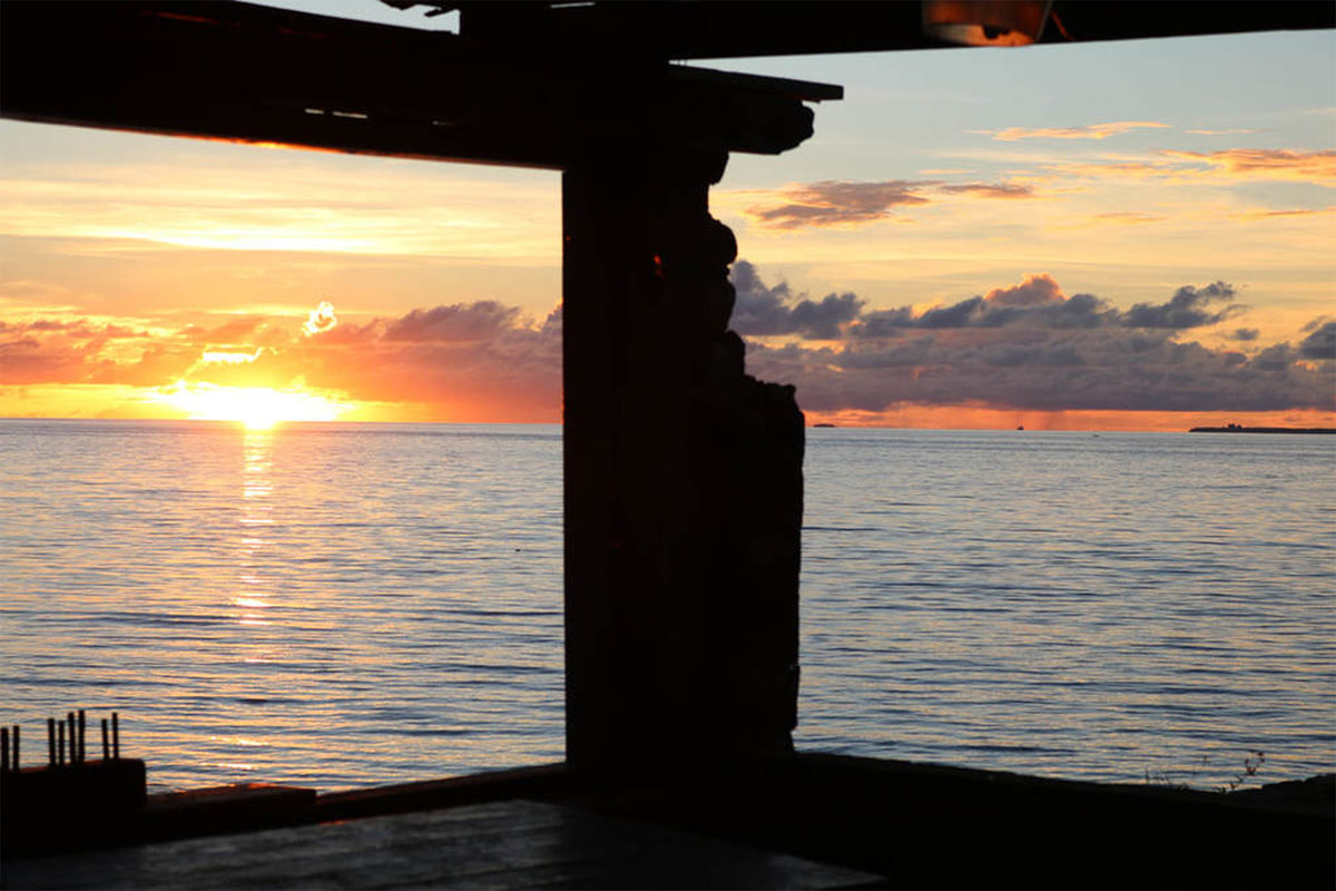
Figure 2
Fern Lehman, “Sunset States,” accessed through https://aeloninaibojooj.weebly.com/portfolio.html.
We have beautiful things, it’s not all climate change, trash and erosion. I like to think that we have something positive to motivate others, so we want to save it. If we always show the negative then why save it? Images of nature are important. Our relationship to nature and seeing beautiful images gets us to pay close attention and to really look.96
Different from colonial photography, which tends to freeze Indigenous life in time, this picture captures the ephemeral moment of the sunset and the eroded pillar, situating climate change in real-time and as lived experience, emphasizing the importance to see “beautiful images” that cultivate intimate relationships. Only one of the many examples that make up the abundance of nuanced visual narratives in Enomoto’s workshop, Lehman’s “Sunset States” goes beyond the binary between the ahistorical paradise and the “no-future” end of the world, and instead presents the liveliness, both beautiful and threatening, of Majuro.
Like the rest of the Pacific, the Marshall Islands are profoundly beautiful. Despite all the ecological destructions, Pacific Islanders like the participants in Enomoto’s photography workshop seek out moments and spaces of beauty on their beloved atolls despite the challenges of settler-colonialism, militarization, and climate change. Discussing how science is inadequate to address the climate movement, CHamoru human rights activist and writer Julian Aguon writes, “We need stories […] about the places we call home. Stories about our own small corners of the Earth as we know them. As we love them.”97 This again demonstrates how different relationships to place generate different stories. The threat of sea level rise is undeniably true for many Pacific Islands. However, it is the love for the many beautiful life forms that make taking no action or leaving a beautiful home behind unbearable. It is through memories of abundance and visions of beautiful futures that Marshallese have endured multiple “end of the world,” while demonstrating resilience and ingenuity. It is for the beauty of the islands that Youth-led Pacific Climate Warriors put up their banner to resist narratives of the disappearing islands, “We are not drowning, we are fighting!”98
Conclusion: Mapping Waters with Poetics
In an article about how Oceania is represented by Indigenous people and foreign voyagers differently, Margaret Jolly brings up the story of Tupaia, who shared cartographic knowledge with Captain Cook through a “double vision,” having both Indigenous ways of mapping spaces and awareness of foreign representation of land and ocean.99 Jolly concludes that while foreigners rely on cartographies to represent “visions of space and time,” Indigenous peoples in Oceania instead turn to genealogy to explain their connection with places and the environment by “lying low in a canoe.”100 Similarly, Dvorak also states that the Kwajalein Atoll is “impossible to represent on a conventional map,” which fails to see the atoll as a “dynamic cosmological system that is multidimensional, abstract, and nuanced…[t]here are even matrices between islets, coralheads, and stars that can only be understood by viewing the lagoon, the horizon, and the sky.”101 Utilizing multiple perspectives and different genres, such as poetry, art, storytelling, Indigenous ways of representing space and time, constitutes an alternative form of mapping that articulates a political imaginary of climate change.
Contemporary political discussion of climate change constructs an epistemological dilemma where critical reflections on science, rationality, and objectivity have been more accepted; meanwhile, “not believing in science” remains a common rhetorical attack against political conservatives. This discursive battle largely determines the shape of the political discussion of climate change, making scientific maps one of the few legible forms of representation.102 Relying on place-based stories, ancestral connections, intuitive practices, and visceral experiences, Indigenous and poetic cartographies show alternative ways of knowing and tending to the environment, which, importantly articulates a politicization of climate change that reveals the responsibility of certain actors and institutions. Meanwhile, the government’s technocratic measures often displace Indigenous communities and knowledge in the name of environmental protection. Alternatively, communities like the Marshall Islands are not just providers of moving stories, Pacific Islanders’ genealogical connections with the environment position them as knowledge holders of specific places, with wisdom from the past to restore abundant futures. Other than just a tool that can be appropriated and simply “consulted” by governments, genealogy acts as a powerful claim to land, calling for a return of Indigenous lands to Indigenous hands, which is necessary for re-enactments of Indigenous community-based stewardship and traditional ecological knowledge that are often more effective than state or private entities in addressing climate change.103
Reflecting on a Marshallese tale, Jetñil-Kijiner comments that “[l]and has power to destroy us. It has eyes. It remembers.”104 The history of environmental degradation is remembered and recorded, including the leaking of radioactive nuclear fallout and the bomb craters that destroyed the lagoons. Indeed, all the creative examples mentioned in this paper have the surging water speak through them to remind us of the ocean’s presence. Babcock reflects that when she hung Lotic Sea on the wall: “it really felt like the sea wants its place at the negotiating table…Not as an empty entity, but a living, breathing, moving, alive collaborator.”105 In an interview, Selina Leem recollects when: “[t]he waves went over the seawall, and crashed into my grandparents’ grave… [t]hat was the first time I felt the wave insulted me. Or like, really demeaned me, by just washing over my grandparents’ graves and bringing all the rubbish that the ocean has.”106 The ocean is communicating with a language that requires poetic attunement and engagement. If we can only look from above and our vision is primarily mediated via pixelated screens, satellite images, and complex simulations, instead of feeling the waves roaring at us, brushing our feet, and if we only rely on the big data to make policies, it is simply not enough to answer the call and respond to the political challenge.
Notes
[1] Selina Neirok Leem, “More than Just a Blue Passport,” in Indigenous Literatures from Micronesia, edited by Evenlyn Flores and Emelihter S. Kihleng, The New Oceania Literary Series. (Honolulu: University of Hawaiʻi Press, 2019), 99.
[2] Selina Neirok Leem, “The Legacy of Nuclear Testing,” Session 1: Envisioning and Imagining Change, The Exchange, East-West Center, September 13, 2021.
[3] “Time Is Running out: Majuro Is Facing a Garbage Crisis,” Pacific Island Times, April 12, 2021, https://www.pacificislandtimes.com/post/time-is-running-out-with-no-room-at-the-dumpsimajuro-is-facing-a-garbage-crisis.
[4] Josh McDaniel, “Rising Oceans, Disappearing Water,” Ka Pili Kai, July 13, 2019, 20–24, https://seagrant.soest.hawaii.edu/rising-oceans-disappearing-waters/.
[6] David Marchese,“Climate Change Is Killing Her Country: Who Will Decide If It Lives?” The New York Times, March 14, 2022, https://www.nytimes.com/interactive/2022/03/14/magazine/tina-stege-interview.html.
[7] A common example: Copernius Climate Change Service, “Copernicus: 2020 Warmest Year on Record for Europe; Globally, 2020 Ties with 2016 for Warmest Year Recorded,” accessed April 8, 2022, https://climate.copernicus.eu/copernicus-2020-warmest-year-record-europe-globally-2020-ties-2016-warmest-year-recorded.
[8] Bjørn Sletto, “Special Issue: Indigenous Cartographies,” Cultural Geographies 16, no. 2 (April 2009), 147.
[10] Studies have been done on the affective and emotional response climate change maps provoke; see Carylyn S. Fish, “Cartographic content analysis of compelling climate change communication,” Cartography and Geographic Information Science 47, no. 6 (November 1, 2020): 492–507. https://doi.org/10.1080/15230406.2020.1774421.
[11] John Brian Harley, “Maps, Knowledge, and Power,” in The New Nature of Maps: Essays in the History of Cartography, edited by Paul Laxton, (Baltimore, MD.: Johns Hopkins University Press, 2002), 54–55.
[13] Jordan Branch, The Cartographic State: Maps, Territory, and the Origins of Sovereignty, (New York, United States: Cambridge University Press, 2013), 3.
[14] Harley, “Maps, Knowledge, and Power,” 59; Bronwen Douglas, “Terra Australis to Oceania,” The Journal of Pacific History 45, no. 2 (September 1, 2010): 179–210, https://doi.org/10.1080/00223344.2010.501696, 209.
[15] Candace Fujikane, Mapping Abundance for a Planetary Future: Kanaka Maoli and Critical Settler Cartographies in Hawai‘i, Durham, NC: Duke University Press, 2021.
[16] Reuben Rose-Redwood, Natchee Blu Barnd, Annita Hetoevėhotohke’e Lucchesi, Sharon Dias, and Wil Patrick. “Decolonizing the Map: Recentering Indigenous Mappings.” Cartographica 55, no. 3 (Fall 2020), 151.
[18] Fujikane, Mapping Abundance, 4. For definitions and explanations of ea in Hawaiian, see Noelani Goodyear-Kaʻōpua, Ikaika Hussey, and Erin Kahunawaikaʻala Wright, eds, A Nation Rising: Hawaiian Movements for Life, Land, and Sovereignty. Narrating Native Histories, (Durham: Duke University Press, 2014).
[19] Rachel Yacaaʔał George, and Sarah Marie Wiebe, “Fluid Decolonial Futures: Water as a Life, Ocean Citizenship and Seascape Relationality.” New Political Science 42, no. 4 (October 1, 2020), 499;
Based on Michel Foucault’s notion of governmentality, where governance depends less upon top-down sovereign power than diffused control and regulation of subjects, Arun Agrawal developed the concept of “environmentality.” Agrawal looks at power relations in environmental governance and the production of human-environment interactions with a focus on conservation efforts; See Arun Arawal, Environmentality: Technologies of Government and the Making of Subjects, (Durham, NC: Duke University Press, 2005);
For settler-colonial governmentality, see Glen Sean Coulthard, Red Skin, White Masks: Rejecting the Colonial Politics of Recognition, Indigenous Americas, (Minneapolis, MN: University of Minnesota press, 2014).
[21] See, for example, Nālani Wilson-Hokowhitu, ed, The Past before Us: Moʻokūʻauhau as Methodology, Indigenous Pacifics, (Honolulu, HI: University of Hawaiʻi Press, 2019); in the same volume, ‘Emi Perkins’s chapter “Moʻokūʻauhau and Mana” offers a comparative reading of theories on Kanaka Maoli genealogies (Moʻokū’auhau and Mana) and the genealogical method as articulated by Michel Foucault and Friedrich Nietzsche. In Perkin’s analysis, both consider genealogy as source of power in its continuity. While Foucaultian genealogical methods deconstruct power by attending to ruptures, Moʻokūʻauhau highlights continuity as critical to endure colonial violence and cultivate Hawaiian identity; as sources of knowledge, both genealogical methods challenge the dominance of science.
[22] Lilikalā K. Kameʻeleihiwa, Native Land and Foreign Desires: Pehea Lā E Pono Ai? How Shall We Live in Harmony?, (Honolulu, HI: Bishop Museum Press, 1992), 20.
[23] Julianne M. Walsh, “Imagining the Marshalls: Chiefs, Tradition, and the State on the Fringes of U.S. Empire,” Dissertation, (University of Hawaiʻi at Mānoa, 2003, 123), https://scholarspace.manoa.hawaii.edu/items/cdd2b2a3-d3f8-4115-8eff-5c7fd741e8e8.
[24] See, for example, “Global Maps,” NASA Earth Observatory, accessed December 11, 2021, https://earthobservatory.nasa.gov/global-maps; “Maps & Data|NOAA Climate.Gov,” accessed December 10, 2021, https://www.climate.gov/maps-data; Yaryna Serkez, “Every Country Has Its Own Climate Risks. What’s Yours?” The New York Times, January 28, 2021; Drew Kann and Brandon Miller, “Climate Crisis: 2020 Was Tied for the Hottest Year Ever Recorded,” CNN, accessed December 10, 2021.
[26] Christopher L. Connery, “Pacific Rim Discourse: the US Global Imaginary in the Late Cold War Years,” Boundary 2, 21, no. 1 (1994): 30–56.
[27] Margaret Jolly, “Imagining Oceania: Indigenous and Foreign Representations of a Sea of Islands,” The Contemporary Pacific 19, no. 2 (2007), 526.
[28] Jolly, “Imagining Oceania,” 527. More on the doomsday vision of economic failure: “…failures of development as measured by gross domestic product; “soaring populations”; unsustainable exploitation of resources; the marginalization of Island economies with globalization; and the withdrawal of powerful aid donors with the end of the cold war. If the nightmare cannot be averted, then overpopulation, poverty, unemployment, ecological devastation, and declining health will surely ensue.”
[29] Martin Heidegger,“The Age of the World View,” translated by Marjorie Grene, Boundary 2 4, no. 2 (1976): 341–55. https://doi.org/10.2307/302139. In this essay, Heidegger discusses how the modern perspective on technology turns everything into “standing reserves,” as “orderly resource for technical application.” This analysis resonates with the extractive cartographic practices that turn land into resources mentioned earlier in this paper.
[30] Jairus Victor Grove, Savage Ecology: War and Geopolitics at the End of the World (Durham, NC: Duke University Press, 2019), 43. More discussion on Europe’s position in the “Anthropocene” framework and responsibility of climate change, see Simon Dalby, Rethinking Environmental Security, Rethinking Political Science and International Studies Series, (Cheltenham, UK; Northampton, MA, USA: Edward Elgar Publishing, 2022).
[33] Doreen B. Massey, For Space (Thousand Oaks, CA: SAGE Publications Inc., 2005), 12.
[35] Kathy Jetñil-Kijiner, “‘Butterfly Thief’ and Complex Narratives of Disappearing Islands,” kathyjetnilkijiner.com. April 30, 2017. https://www.kathyjetnilkijiner.com/butterfly-thief-and-complex-narratives-of-disappearing-islands/.
[36] Christina Gerhardt and Emily Busch, “Rising Sea Levels—Marshall Islands: Majuro Atoll by 2055,” in Water: An Atlas, edited by Darin Jensen, Alicia Cowart, Susan Powell, Molly Roy, Chandler Sterling, and Maia Wachtel. (Guerilla Cartography: 2017), 173–174.
[37] Castle Bravo was part of Operation Castle conducted by the U.S. Atomic Energy Commission and Department of Defense. Its denotation produced 15 megaton yield, resulting in severe radiation exposure on the environment and Marshallese people. The destruction of Castle Bravo and many other nuclear denotations from 1940s and 1950s still haunts the Marshall Islands, where people couldn’t return to their home atoll, suffer from radiation health effects, and still live with the radioactive waste left by the United States.
Ariana Rowberry, “Castle Bravo: The Largest U.S. Nuclear Explosion,” Brookings, February 27, 2014. https://www.brookings.edu/articles/castle-bravo-the-largest-u-s-nuclear-explosion/; Holly M. Barker, Bravo for the Marshallese: Regaining Control in a Post-Nuclear, Post-Colonial World, (Australia; Belmont, CA: Thomson/Wadsworth, 2004).
[39] UHM TV, “Opening Artist Talks,” Youtube video, March 14, 2020. 1:30:01, https://www.youtube.com/watch?v=SdoNwBsl6BY.
[40] Susan Hoffman Fishman, “Woven and Waxed Water Stories,” Artists & Climate Change, May 31, 2021, https://artistsandclimatechange.com/2021/05/31/woven-and-waxed-water-stories/.
[41] Mary Babcock, Lotic Sea, 2020, 14’×14’×14’, installation with hand-laminated and stitched household wax paper, sea salt, 2020, University of Hawaii at Manoa Art Gallery, Honolulu, HI. https://www.marybabcock.com/Lotic-Sea. Fishman, “Woven and Waxed Water Stories.”
[42] NOAA Ocean Exploration, “What Is the ‘EEZ’?: Exploration Facts: NOAA Office of Ocean Exploration and Research,” accessed June 10, 2023. https://oceanexplorer.noaa.gov/facts/useez.html; Alister Doyle, “Islands, Rocks, and Tuna: Pacific nations draw new battle lines against rising seas,” https://www.reuters.com/article/us-climate-change-pacific-fishing-trfn/islands-rocks-and-tuna-pacific-nations-draw-new-battle-lines-against-rising-seas-idUSKBN2B3054.
[44] Alister Doyle, “Islands, Rocks, and Tuna: Pacific Nations Draw New Battle Lines against Rising Seas,” https://www.reuters.com/article/us-climate-change-pacific-fishing-trfn/islands-rocks-and-tuna-pacific-nations-draw-new-battle-lines-against-rising-seas-idUSKBN2B3054.
[45] Elizabeth M. DeLoughrey, “The Myth of Isolates: Ecosystem Ecologies in the Nuclear Pacific,” Cultural Geographies 20, no. 2 (April 2013): 169, 178.
[48] Kathy Jetñil-Kijiner, “Tell Them,” in Iep Jāltok: Poems from a Marshallese Daughter, (Tuscon, AZ: The University of Arizona Press, 2017), 66.
[49] Ulises A. Mejias and Nick Couldry, “Datafication,” Internet Policy Review 8, no. 4 (November 29, 2019), 1–10, https://policyreview.info/concepts/datafication.
[51] Dalby, Rethinking Environmental Security, 89. For example, in the Paris Agreement in 2015, 2° Celsius was decided as the upper limit for global warming, to which Marshallese responded with “1.5 to stay alive.” Ari Shapiro,“For The Marshall Islands, The Climate Goal Is ‘1.5 To Stay Alive,’” NPR, December 9, 2015, https://www.npr.org/sections/parallels/2015/12/09/459053208/for-the-marshall-islands-the-climate-goal-is-1-5-to-stay-alive.
[53] “Sea Level Change (1993–2020),” NOAA Climate.gov, data from UHSLC, https://www.climate.gov/news-features/understanding-climate/climate-change-global-sea-level.
[54] Mark S. Monmonier, Coast Lines: How Mapmakers Frame the World and Chart Environmental Change, (Chicago, IL: University of Chicago Press, 2008), 146. Especially in global maps, significant impacts at the local level are often trivialized due to its global scale.
[55] For example, see “Sea Level Rise,” Atlas at the End of the World, accessed on November 19, 2021. https://atlas-for-the-end-of-the-world.com/world_maps/world_maps_sea_level_rise.html.
[56] See, for example: Jay T. Johnson, Renee Pualani Louis, and Albertus Hadi Pramono, “Facing the Future: Encouraging Critical Cartographic Literacies In Indigenous Communities,” ACME: An International Journal for Critical Geographies 4, no. 1 (2005): 80–98.
[57] Jolly, “Imagining Oceania,” 515.
While land is privately owned by Marshallese citizens in the Republic of the Marshall Islands, customary land tenure depends on familial lineages and social status, which pose challenges to foreigners’ access to land. See United States Department of State, “2019 Investment Climate Statements: Marshall Islands,” accessed July 20, 2023. https://www.state.gov/reports/2019-investment-climate-statements/marshall-islands/; Jack Tobin, “Land Tenure in the Marshall Islands,” Atoll Research Bulletin, no. 11 (1952): 1–36.
[58] ʻUmi Perkins, “Moʻokūʻauhau and Mana,” in The Past before Us: Moʻokūʻauhau as Methodology, edited by Nālani Wilson-Hokowhitu, Indigenous Pacifics, (Honolulu, HI: University of Hawaiʻi Press, 2019), 77.
[59] Kathy Jetñil-Kijiner, Leora Kava, and Craig Santos Perez, eds. Indigenous Pacific Islander Eco-Literatures, (Honolulu, HI: University of Hawaii Press, 2022), xv.
[60] Philip Steinberg and Kimberley Peters, “Wet Ontologies, Fluid Spaces: Giving Depth to Volume through Oceanic Thinking,” Environment and Planning D: Society and Space 33, no. 2 (April 2015): 247–64. https://doi.org/10.1068/d14148p, 248.
[61] Tiffany Lethabo King, The Black Shoals: Offshore Formations of Black and Native Studies, (Durham, NC: Duke University Press, 2019), 3.
[62] Selina Neirok Leem, “Transcript: A Homeland Swallowed by The Sea,” interview by John Hockenberry, The Takeaway, WNYC Studios, March 18, 2016, https://www.wnycstudios.org/podcasts/takeaway/articles/transcript-homeland-swallowed-sea.
[63] Leem in “A Homeland Swallowed by the Sea” mentioned that she “grew up with these inundations” but started to worry more around the early 2010s. Also note that flooding and inundations themselves do not equate climate change, which is more often experienced as disruptions of regular weather patterns and the failure of “system[s] of preparedness for floods,” especially in coastal and low-lying areas where flooding is “normal.” Michelle Harangody, Mehana Blaich Vaughan, Laurie S. Richmond, and Kristine Kilikina Luebbe. “Hālana Ka Manaʻo: Place-Based Connection as a Source of Long-Term Resilience,” Ecology and Society 27, no. 4 (November 26, 2022).
[64] Selina Neirok Leem, “Climate Change Advocate,” The United World Colleges, accessed November 28, 2021, https://www.uwc.org/selinaleem.
[67] “Seawalls going up all over,” The Marshall Islands Journal, October 11, 2019, https://marshallislandsjournal.com/seawalls-going-up-all-over/.
[68] “Reducing the Carbon Footprint of Concrete Based Marine Infrastructure,” ECOncrete, December 9, 2017, https://econcretetech.com/blogcat/reducing-the-carbon-footprint-of-concrete-marine-infrastructure/.
Aliya Uteuova, “Can Nature-Based Alternatives to Seawalls Keep the Waves at Bay?” The Guardian, August 12, 2022, https://www.theguardian.com/us-news/2022/aug/12/seawalls-nature-based-alternatives-us.
[69] Judy Rohrer, “Rising Sea Level and Settler Hubris Ahead,” CounterPunch, July 27, 2022. https://www.counterpunch.org/2022/07/27/rising-sea-level-and-settler-hubris-ahead/.
[72] Lancester University, “U.S. Military Consumes More Hydrocarbons than Most Countries—Massive Hidden Impact on Climate,” Science Daily, June 20, 2019. https://www.sciencedaily.com/releases/2019/06/190620100005.htm.
[74] Julian Aguon, “To Hell With Drowning,” The Atlantic, November 1, 2021, https://www.theatlantic.com/culture/archive/2021/11/oceania-pacific-climate-change-stories/620570/.
[75] William A. Callahan, Sensible Politics: Visualizing International Relations, (New York, NY: Oxford University Press, 2020), 8, 171.
[76] Coulthard, Red Skin, White Masks. In this book, Coulthard scrutinizes the colonial “politics of recognition,” which is partly facilitated by visibility and identity politics.
[77] Coral Davenport and Josh Haner, “The Marshall Islands Are Disappearing,” The New York Times, December 1, 2015, https://www.nytimes.com/interactive/2015/12/02/world/The-Marshall-Islands-Are-Disappearing.html.
[78] See “Map by Gotō and Suzuki 1885,” in Greg Dvorak, Coral and Concrete: Remembering Kwajalein Atoll between Japan, America, and the Marshall Islands, Asia Pacific Flows, (Honolulu, HI: University of Hawaiʻi Press, 2018), 43–44.
[80] DeLoughrey, “The Myth of Isolates,” 168. The technologies of aerial photography and satellite imagery are closely connected. According to geographer Mark S. Monmonier, coastal cartography in particular, was made possible by aerial photographic surveying.
In DeLoughrey’s other article, “The Sea is Rising: Visualizing Climate Change in the Pacific Islands,” Pacific Dynamics: Journal of Interdisciplinary Research 2, no. 2 (November 2018): 185; she also connects visualizing climate change on earth island with Cold War satellite technologies.
For early modern cartography using aerial photography and aerial survey, see “The Long Road to Modern Cartography,” Unearth, accessed March 20, 2022, https://www.unearthlabs.com/blogs/modern-cartography.
[81] Kathy Jetñil-Kijiner, “Midnight: Fighting for Our Survival,” with Kirsten Lami Maddison, Clarence Samuel, Broderick Menke, and Andrea Muller, filmed December 2020, 350 Pacific CVF Series. https://www.kathyjetnilkijiner.com/fighting-for-our-survival-350-pacific-cvf-series/.
[82] Adolph Reed, “Nothing Left: The Long, Slow Surrender of American Liberals.” Harper’s Magazine, March 2014. https://harpers.org/archive/2014/03/nothing-left-2/. The urge to bear witness is reflected in the countless numerous journalistic accounts on the disappearing islands and the need to keeping track of the number of islands that are disappearing. See, for example, Denise Chow, “Three Islands Disappeared in the Past Year. Is Climate Change to Blame?” NBC News, June 9, 2019, https://www.nbcnews.com/mach/science/three-islands-disappeared-past-year-climate-change-blame-ncna1015316.
[83] Joy Lehuanani Enomoto, “AELÕÑ IN AIBOJOOJ: Visual Reclamation of Marshallese Self-Representation,” Master’s portfolio, (University of Hawaiʻi at Manoa, 2019). http://scholarspace.manoa.hawaii.edu/handle/10125/66551.
[86] See Teresia K. Teaiwa, “Bikinis and Other s/Pacific n/Oceans,” The Contemporary Pacific 6, no. 1 (1994): 91–93; and “Reflections on Militourism, US Imperialism, and American Studies,” American Quarterly 68, no. 3 (2016): 847–53. https://doi.org/10.1353/aq.2016.0068.
[87] Kalissa Alexeyeff and Siobhan McDonnell, “Whose Paradise? Encounter, Exchange, and Exploitation,” The Contemporary Pacific 30, no. 2 (2018): 269–295.
[88] For example, Chelsea Stuart, “8 Disappearing Islands to Visit NOW—Before It’s Too Late,” Jetsetter Magazine, December 2, 2019, https://www.jetsetter.com/magazine/islands-to-visit-before-they-disappear/.
[90] “Jo-Jikum” means “your home” “your place.” It is a Marshall Islands-based climate advocacy nonprofit, founded by Kathy Jetñil-Kijiner. See the website here: https://jojikum.org/.
[93] Fern Lehman, “Sunset States,” accessed on November 29, 2021. https://aeloninaibojooj.weebly.com/portfolio.html.
[98] Fenton Lutunatabua, “Pacific Climate Warriors: ‘We Are Not Drowning, We Are Fighting,’” Global Voices, January 21, 2014. https://globalvoices.org/2014/01/21/pacific-climate-warriors-we-are-not-drowning-we-are-fighting/.
[102] Amitav Ghosh. The Nutmeg’s Curse: Parables for a Planet in Crisis, (Chicago, IL: University of Chicago Press, 2021).This echoes Amitav Ghosh’s comment: while climate change issues are prioritized geopolitically, it is the scientists and politicians who have been dictating the discussions, ignoring “unprofessional” voices that are coming from people who live with climate change day by day. These voices are dismissed as less valid, even though many “non-scientists” have place-based and Indigenous knowledge to address ecological challenges.
[103] See for example, Fikret Berkes, Advanced Introduction to Community-Based Conservation, Elgar Advanced Introductions, (Northampton, UK: Edward Elgar Publishing, 2021).
[104] Kathy Jetñil-Kijiner, “Luerkoklik and the Role of the Land in the Climate Movement.” Ke Kaupu Hehi Ale, June 26, 2015. https://hehiale.com/2015/06/26/luerkoklik-and-the-role-of-the-land-in-the-climate-movement/.
[105] Babcock, speaker, “Opening Artist Talks—Inundation 2020.”
Acknowledgements
Right after I arrived in Hawaiʻi in late August, 2021, I attended a talk given by Selina Neirok Leem, whose powerful storytelling has forever changed my sensibility and understanding of climate change. My engagement with sea level rise in the Marshall Islands is a direct result of that encounter, and I am grateful for her presence and insight that evening. This paper is originally submitted as a seminar paper to the Fall 2021 graduate seminar on Indigenous Politics at the University of Hawaiʻi at Mānoa with Dr. Noenoe Silva, without whom this work wouldn’t be possible. I am grateful to my colleagues in the seminar who inspired my thinking and writing, including Benjaluck Sai Denduang, Edward Leon Guerro, and Tiffany Beam. I want to thank Kathy Ferguson, Samson Opondo, Jairus Grove, who have guided me through the edits and conference presentations with great care. This polished version is indebted to the community of scholars in my writing group and beyond: Ruoyu Li, Yinguang Zhao, Sara Saastamoinen, Steffanie Sobitz, Hannah Hymann, Heather Jacobs, Jeniffer Joines, and Ariel Mota Alves. Last but not least, I want to thank the anonymous reviewers and editors of the SPECTRA journal for their helpful critiques and feedback, especially to Samuel Beckenhauer, for your patient edits and guidance in this process. Thank you all, for your kindness, generosity, and care.
Competing Interests
The author has no competing interests to declare.