
1 Introduction
Increasingly, the remote viewing technologies through which we predominantly see things happening in the world are getting in the way of seeing. This unintended consequence has been highlighted through a slew of media images, especially apparent in those from the perspective of looking up at the sky and beyond, as a site laden with panoptic technologies busy trying to see the whole of things. As much critical attention as there has been on the techno-mediated view from above, especially concerning the advent of surveillance technologies within cultural and science and technology studies,1 what would it mean to resituate our consideration to the view from the ground and the forms of partial visibility that are inscribed there? Considering this, what to make of the sky and cosmos as sites increasingly overloaded with technical infrastructures of connectivity and remote viewing, so much so that these technologies seem to actively intervene in the visual capture of these environments?
Lisa Parks, in her cultural analysis of the history of satellite technology, defines the ‘televisual’ as a term that concerns a set of technologies of seeing and knowing from a distance that also includes the epistemological systems, knowledge practices, and ways of seeing that frame and enculture its output and processes.2 This paper analyses the centrality of the ‘visual’ in the televisual, specifically concerning the visibility of remote infrastructures of televisual technologies and the ways in which they mark environmental disruption in the intractable site of the atmosphere. Satellites, surveillance balloons, space-based telescopes, and rovers are all televisual technologies that reside in atmospheric and cosmic environments generating visual data through infrastructures of wireless technology to produce what is considered ‘actionable knowledge’ about the environment both on earth and in the cosmos. Technologies such as these have been referred to as forms of ‘environing technology’, a theoretical concept that addresses how technologies intervene in shaping and forming our understanding of nature.3 In discerning between nature and environment as ontological categories and focusing on technology in constituting the latter, environing technologies are described as, ‘on the one hand directly reshap[ing] nature into environment in some form, and, on the other hand, show[ing] us nature in a specific way and thereby limit or expand our idea of what we can achieve with and in nature’.4 In the transformation of ‘environment’ from a noun to a verb, ‘environing’ shifts focus towards an agency of ‘environmental making’ through technology – including imaging and its multi-layered processes – in which environments are formed.
Thinking through the lens of environing and the televisual within cultural terms, this paper looks at images that capture the material infrastructures of wireless technologies in the remote site of the atmosphere and above. These images originate within scientific contexts, yet once taken out of this epistemic framing and placed in the realm of the public imaginary, these images contribute to an aesthetics of wireless communication.
Images that capture the material infrastructures in the sky and cosmos have been popularised because of their unintended, spectacular and ludic appearance as well as subjective qualities that are assigned to these technologies. Some of these images are understood as an ‘accident’, and mark a shift in their significance from an exclusive source of scientific data to the field of cultural operations. For example, in otherwise pristine images produced by the space-based Hubble telescope, the interruption of light reflecting off of satellites in low earth orbit produce visual aberrations and have been described by journalists as photobombing.5This term became popularized in the context of online social media and describes the act of redirecting the attention of an image to an unintended and unplanned subject often in humorous light, which takes the centre of attention and, as such, gets in the way of clear sight of the intended subject. As an image genre, it has been defined by the cultural scholar Yasmin Ibrahim as an image,
where a transgressive object or entity within a conventional image setting subverts it, adding popular appeal through its ability to reconfigure its aesthetic conventions, opening it up for public pleasure and consumption…due to its incongruence and ludic qualities in destabilising the conventions of the image.6
Other images that have been popularised and mark the visibility of the material infrastructures of remote wireless technologies involve self-captured images, such as those produced by the Perseverance Rover and Ingenuity Helicopter who, during their mission on Mars seem to be taking selfies, while doing their ‘other’ job. Another genre of image that gained prominence on social networks, selfies involve posting self portraits in virtual spaces that include the marking of one’s presence in a particular place and time – a kind of visual form of the unsanctioned scribble found inscribed on school desks of, ‘I was here’. Selfies involve a performance of self through a relationship between the author and the camera apparatus as a visual organising principle and have been argued to contribute to the formation of subjectivities online.7 As Media Studies scholar Katie Warfield has discussed, the selfie is at once a, ‘mirror, and a camera, and a stage or billboard all at once’.8 In drawing on the terms photobombing and selfies here, I mean to emphasise possible subjectivities that become realized through these technologies – that is, a quality of subject formation through the affordances of their situated perspectives and the ‘making’ of environments. These image genres when applied to the visibility of the material infrastructures of televisual technologies imbue them with forms of subjective agency, through the ways that their presence both characterise and narrativise our environments. These televisual technologies of remote viewing often stand in for our own proximity to the environments they produce data about. Their infrastructures structure our ways of seeing, expanding the fields of visibility and yet they also at times get in the way of seeing and appear as part of the environments they produce data about. In attending to this latter aspect, I want to point towards something that is often overlooked, that is the growing ubiquity of these technologies in the atmospheric environment as constructing its own aesthetic. The visual capture of their material infrastructure often interrupts ‘normal programming’, and absorbs the attention through what was once considered incongruent to the alterity of the sky and atmosphere.
2 The View from Below
On February 2, 2023, a surveillance balloon was reported to be flying over the United States in an event that has since been referred to by the US. press as the ‘2023 Chinese Balloon Incident’. An image of the balloon circulated widely across global news outlets, depicting a floating, white, almost-translucent orb. (Figure 1) Attached to it was a row of solar panels, like a miniature satellite soaring within Earth’s atmosphere. The pixelation of the image indicated a zoomed-in closeup taken at a distance from the ground. From this distance, it was nearly impossible to discern the giant scale of the actual balloon, which measured 150 feet in diameter. The balloon’s path and size were tracked by an AI startup called Synthetaic using Earth-imaging data, algorithmic measurements of pixels, and satellite imagery.9 The balloon had been flying over US airspace since January 28th and was eventually shot down over the coast of South Carolina by the US Air Force on February 4th. Widely circulated photographs of the spy balloon conjured up an iconic image.

Figure 1
File photo of a suspected Chinese spy balloon over Montana. Photograph: Chase Doak/AFP/Getty Images.
The balloon’s sudden visibility could be described as a photobombing of the sky by an unknown flying object, in its unexpected and unplanned appearance in an otherwise open canvas of visibility. As Ibrahim has theorised, photobombing reflects an aesthetic mode of the digital age and, in an age of distraction, where the unexpected acts as spectacle or, as she describes it, becomes a mode of ‘ocular appeal’ in the digital environment.10 In this case, the sudden appearance of the balloon in the sky was the spectacle and the main cause for its widespread image capture and thus the main subject of the captured images. Yet, its presence in the sky was incongruent to the environment of the sky enacting this aesthetic mode of a photobomb and signalling the presence of possibly more nefarious and transgressive agents behind its existence. Flying somewhere between 60,000 and 80,000 feet in the air, the balloon appeared like a remote ‘message in a bottle’ communicating that the sky is filled with monitoring, observational, and sensing technologies.
The ‘Chinese balloon incident’ illuminates what Paul Virilio calls ‘the logistics of perception’, that is, the material and technical organisation of vision as it facilitates action across different operational agendas, in this case in the capture and processing of data for surveillance purposes.11 According to the US government, the balloon was a Chinese government-run spy balloon that had violated the sovereignty of US airspace, and allegedly had the capacity to geolocate electronic communications and gather intelligence over several sensitive US military sites, such as the Malmstrom Air Force Base in Montana, which it repeatedly passed over.12 After the balloon had been shot down and its components analysed, U.S. reports detailed that the intelligence gathered was mostly electronic signals rather than pictures. The Chinese government claimed that the balloon was a civilian meteorological airship, essentially a weather balloon, that had been blown off course and whose position over US airspace was arbitrary. These contrasting narratives of the operational utility of the balloon and the reason for its location, whether for an operational military surveillance vehicle or an innocuous vehicle of environmental monitoring, exemplify a wider intersection of environmental and military sensing operations. This intersection has been described by the term, ‘dual-use technology’ where military-driven imperatives in the implementation and development of technologies are transferred to civilian use.13 Yet the balloon itself and the conflicting narratives over its operations are also expressive of a dual logic concerning the infrastructures of wireless surveillance, which operate within borderless, invisible and non-territorial spaces of control, something that is reflected in the medium of the open sky when viewed from below. And yet its appearance floating over several states of the U.S, expressed a major transgression of the borders of geopolitically defined airspace.
The apparatus of the balloon itself, a seemingly archaic and ludic device, contrasts from the kinds of aesthetics we may associate with contemporary infrastructures of surveillance and control with characteristics of being immaterial, networked and invisible. The reference by the Chinese government about the balloon being blown off course, also references the unruliness of the medium of wind, the radical opposite of control.14 The balloon, as it was later revealed to indeed be part of a Chinese military spy operation, was the visible part of an often invisible operation. Instead of collecting visual reconnaissance data through an abstracted ‘view from above’ – an origin use of balloons in the context of surveillance15 – the Chinese spy balloon is a rare glimpse of the material infrastructure of the wireless prosthetic devices of surveillance systems that instead collect data by electronic signals. News headlines stated ‘eyes on the sky’ describing masses of people looking up at the balloon as it crossed several states.16 Its visibility lended itself to the embodied, naked eye from a grounded and one could say territorialised ‘view from below’ fixating on an eye in the sky. But rather than an eye, the balloon encapsulates a sensor, its operations relying on the invisual range of the electromagnetic spectrum and instead involving the interception of signals and data transmission. The image of the balloon encapsulates a moment then of visual non-reciprocity.
It was reported that the balloon itself was not understood to be a real threat in terms of the transmission of reconnaissance data, but rather a message.17 Indeed, for weeks after this event, a slew of sightings of other unfamiliar vehicles and balloons in the sky were discussed in the news with a seeming novel awareness of the ‘unnatural’ objects that inhabit the sky and extend into the atmosphere above.18 In response to images of the balloon, there was widespread attentiveness and scepticism regarding the number of random objects visible in the atmosphere. The visibility of the balloon brought awareness of the sky as a site of distanced and unregulated perception. Its arrest in the sky illustrates a rare viewing of the material infrastructures of wireless technologies taking centre stage in the site of the earth’s atmosphere, from the usual invisibility of networked surveillance operations. Standing at the opposite operational spectrum of control and regulation through surveillance, the image of the balloon is organised by a view from below, through an embodied and situated perspective, a perspective epistemically linked with curiosity, wonder and uncertainty. The increasing material presence of scopic, surveilling, and monitoring technologies is, at once, becoming a part of and partial to atmospheric environments. Perhaps, this fact further indicates that characterising their appearance as photobombing – that is, as unexpected and spectacular – may be momentary, as increasing visibility of the infrastructures that organise and make possible our wireless communications on earth force the attention upwards.
3 Satellite Photobombing and False Stars
The night sky is currently being outfitted with what has been referred to as ‘false stars’, lights that reflect and emanate from satellites. About 100 km from the surface of the earth, there exists an invisible boundary between geopolitically organised airspace and what is considered the non-territorial space of outerspace known as the Kármán Line.19 This line, named after the aerospace pioneer, Theodore von Kármán is based on the technical limitations of traditional aircraft that rely on gravitational lift from earth’s atmosphere but also organizes the limits of geopolitical boundaries, that is, that there are no national borders – analogous to the governing of international waters – that extend above this line. Yet, the site above this line has become filled with commercial exploitation with ties to national and geopolitical agendas through the exponential growth of satellite systems, the aesthetics of which I argue, are expressed through what has become to be known as ‘false stars’. The uniformity of light points of satellites contrasts with the stable, yet random, distribution of stars in constellations. (Figure 2) Star constellations have historically provided orientation, indicating one’s position on Earth and helping to navigate local terrain. The steady positioning of constellations in the night sky lies outside of systems of sociopolitical and human intervention; in other words, they represent a system of radical otherness, an example of what Gayatri Spivak refers to as systems of alterity.20 From afar, the visibility of satellites transforms the night sky into a constellation of orbital infrastructures of privatisation and capitalist expansion.21 The visibility of satellite systems in the night sky is symptomatic of a disruption in the spaces and scales of navigation. The increasing necessity of global internet access, which drives the escalation of satellite systems, reflects a shift in the spaces and scales of navigation. The embodied vision by which historically, we could look up and see star constellations as sources of stable reference for our own positioning on earth shifts to the screen of our phones and the networked satellite systems of navigation such as GPS that provide ‘realtime’ geopositioning via virtual and geospatial mapping. The uniformity of ‘false stars’ is reflective of a kind of industrialisation of vision through navigation systems connecting non-contiguous areas into a continuous geography.
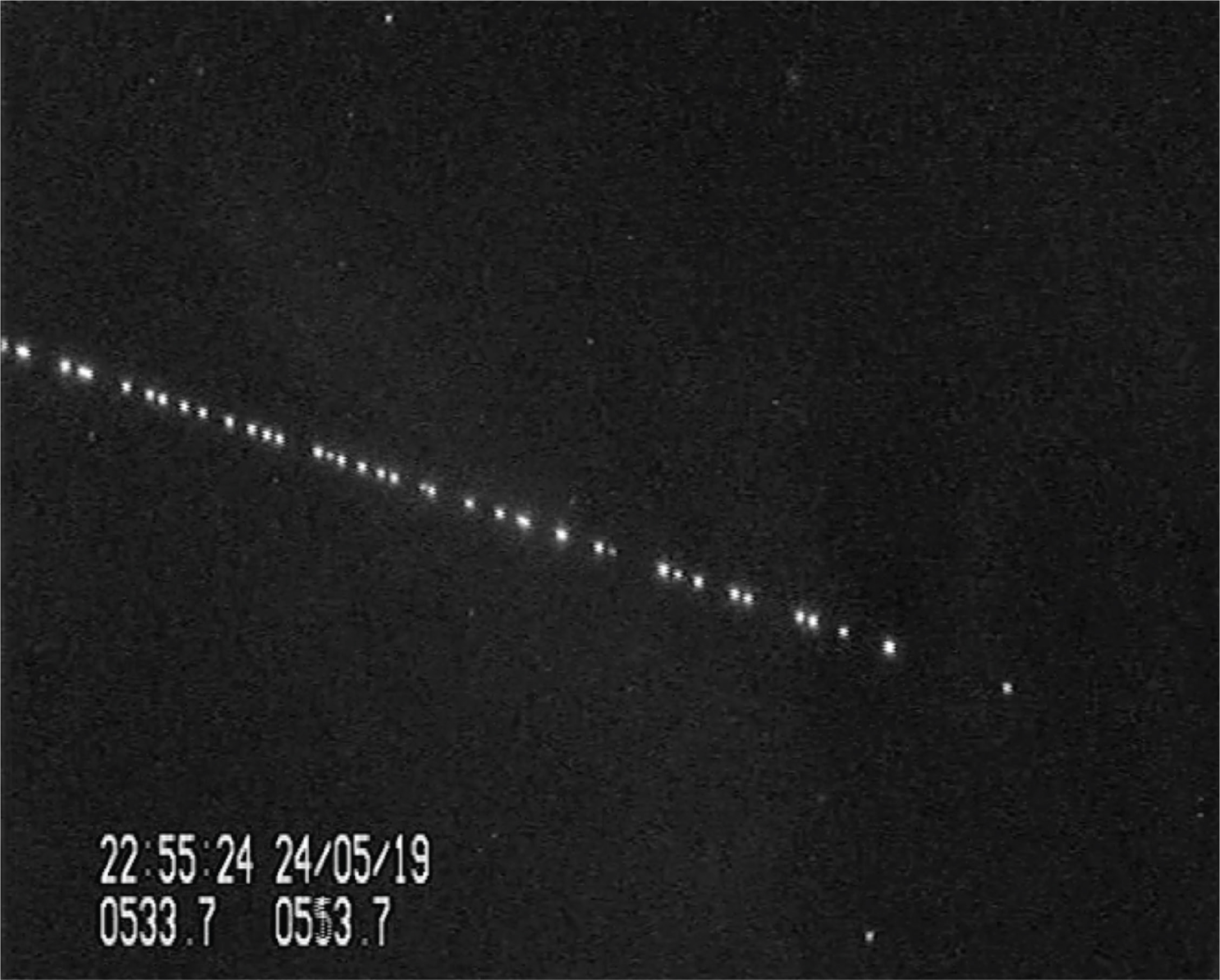
Figure 2
A constellation of Starlink satellites seen in the night sky over the Netherlands, nearly 24 hours after being launched by SpaceX in May 2019. Credit by Marco Langbroek Via Reuters.
Both the scientific community and cultural scholars argue that the sky is being lost ‘as a province of all mankind’ as a result of private corporate takeover.22 In 2019, Elon Musk’s SpaceX Starlink program launched 500 satellites into low Earth orbit. According to a satellite-tracking site as of March 2025, there are reportedly a total of around 11,833 satellites in orbit around the Earth with over 7,000 of them being the privately owned satellites operated by Musk’s Starlink program, with eventual plans to expand the fleet to 42,000.23 Other private companies that own and operate satellites are Amazon’s Project Kuiper, British-owned OneWeb, and Chinese-owned Galaxy Space. This techno-capitalist mode of cosmic infrastructural expansion has its entanglements with the military context too, directing the logistics of on-the-ground, tactical capabilities. As has been reported, Musk’s Starlink satellites have been instrumental in the current conflict of the Russian invasion of Ukraine, in ways that non-military contractors have never been before.24 It was reported that Musk made the decision to deny satellite access to prevent a Ukrainian drone attack on a Russian naval fleet. Through a process known as ‘geofencing’ which restricts where connectivity is available on the front lines, Starlink and Musk have prompted concerns about how a commercial, non-military agent could wield so much control in a war zone. This unprecedented control is made visible through its material logistics in the night sky and the visible production of false stars. This new breed of celestial object not only intervenes in what was once a site of reference for stable orientation but also reflects the conditions of the networked navigational capabilities in current wars.
For the scientific community, the light reflected off the solar panels on satellites, photobomb the images produced through the Hubble Telescope. (Figure 3.) Astronomers complain that it is like, ‘staring at the cosmos through a field of satellites’.25 The image output of outer space telescopes such as the Hubble Telescope, is obscured by what has now been termed as ‘satellite photobombing’ which create visible aberrations in images including illuminated streaks of moving satellites crossing the image and/or diffracted spikes of light which emanate from them.26 This is especially visible in images taken with long exposure times and a larger scope. Historically, certain Hubble telescopic images have become media events that showcase the miraculous sharpness of its output and the capture of remote, cosmic events for domestic viewing.27 Satellite photobombing presents another type of image turned media event, one that highlights an unintentionality and, with it, an uncertainty of partial vision in space, signalling the presence of the multitude of apparatuses that mark a techno-mediated landscape of the cosmos. In the movement of these Hubble images beyond the operational contexts of their production and into the media landscape, they become, as Parks has described, ‘contested discursive terrains’ that concretise standards for various forms of operational media.28 The emitting light of satellites becomes a fixture that environs the cosmic landscape, transforming the once-exclusive space of a system of alterity, one could say, displacing the stable and cyclical movement of constellations with increasing traffic of aesthetic artefacts of the material and light-emitting infrastructures that reflect agendas of geopolitical relations on earth.
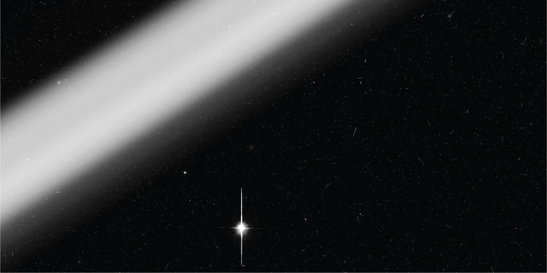
Figure 3
A bright, close, and out-of-focus satellite trail captured by Hubble. Credit NASA, ESA, Kruk et al.
4 Selfies in the navigational image
Navigation through imagery is occurring higher in orbit where data in the form of Martian landscape images depicting the red planet’s topography is made accessible to the public through NASA’s website. The images are produced through the scopic lens and mobile embodiment of the Perseverance Rover, as well as through its accompanying drone, Ingenuity (nicknamed ‘Ginny’).29 The Perseverance rover with its attached cameras has made a total of 819,875 raw images – or to be more specific, multilayered data that is then transformed into images – as of April 2025.30 It is also capable of collecting material sediment which it drills from the planet’s surface, to be further analysed at a later date. Collecting both physical and visual data, Perseverance is part of a larger project to search for signs of ancient microbial life and researching possible habitation on Mars.
The archive of images produced by Perseverance facilitates a planetological study by providing a visual record of the chemical composition, topography, and overall mapping of this remote physical landscape. It also contributes to a visual culture of planetary imagination and the production of place and subjectivity.31 In contrast to previously captured flyby images of Mars that encompass a distanced view of the entirety of the planet, the positioning of Perseverance and Ginny on the ground produces images from a ‘first-person’ point of view.
On its website, NASA invites the public to vote for an ‘Image of the Week’. The most popular images include depictions of Perseverance and Ginny, or, rather, their traces left in the landscape – images of their abandoned parts left on the ground, the holes that Perseverance drills and marks the landscape with, their tracks imprinted on the ground. Perhaps these images are popular because they interrupt the landscape with an indexical sign of our own presence through the physicality of the televisual sensing apparatus leaving its prosthetic mark.
One image that has garnered much attention depicts both robots nestled in the Mars landscape. On April 24, 2023, Ginny captured an image from a Martian aerial perspective of Perseverance roving the landscape, as well as themself through the silhouette of their shadow. (Figure 4) The perspective in this landscape image is diagonal, looking down towards the ground with a sliver of the blue sky above. Slightly off centre in the foreground, towards the right, is a bright halo of light that draws the eye. At the centre of this halo is the stark silhouette of Ginny, the author of the image. In the distance, in the upper left-hand corner within the vast desert-like landscape, is the tiny figure of Perseverance roaming in a state of discovery. We can make out the lone figure of the rover, set aloft on two rows of wheels with its attached camera head on top. Rather than a photobomb, this image instead has the visual logics of a selfie, with Ginny producing an image of self through their shadow coupled with Perseverance, visualising a kind of relational subjectivity between a temporal embodied presence and place.
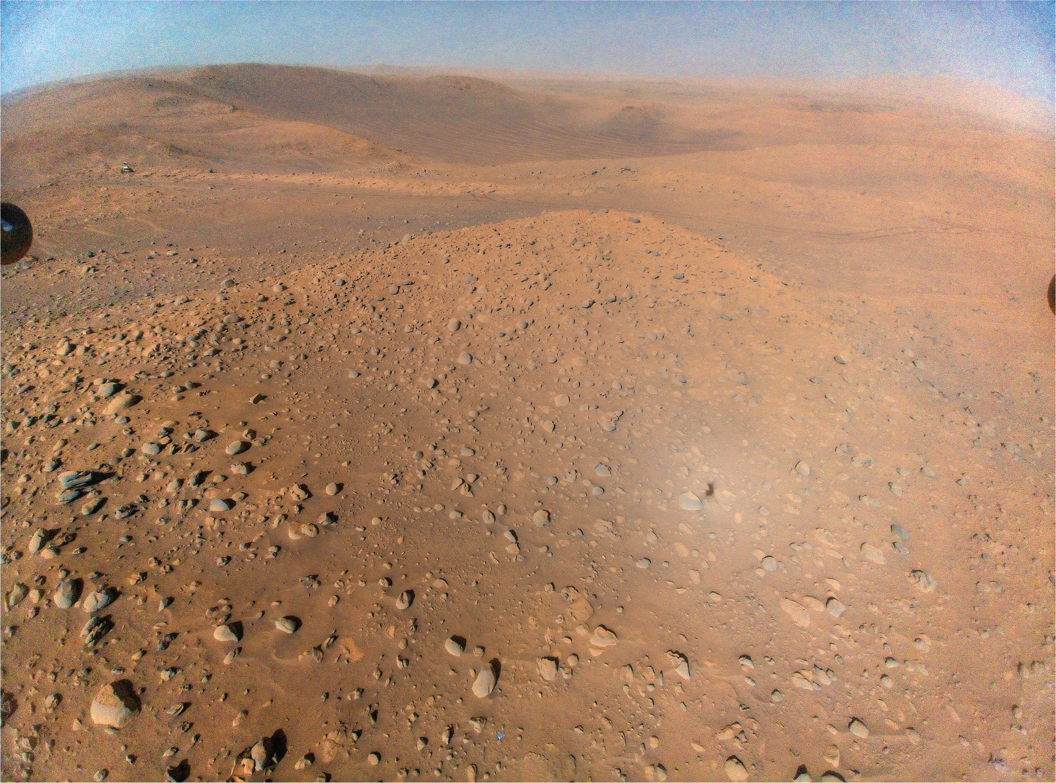
Figure 4
This image of NASA’s Perseverance Mars rover at the rim of Belva Crater was taken by the agency’s Ingenuity Mars Helicopter during the rotorcraft’s 51st flight on April 22, 2023, the 772nd Martian day, or sol, of the rover’s mission. Credit. National Aeronautics and Space Administration.
Looking at Ginny’s selfie taken in the cosmic landscape of Mars, I cannot help but think of the composition of another cosmically referenced selfie taken by the artist Judy Dater titled, ‘Self-Portrait at Craters of the Moon’ (1981). (Figure 5) In the latter, there are two figures present in the image: firstly, the stark, naked body of the photographer and, secondly, the silhouette of a camera on a tripod, the apparatus that captures the image. Instead of the actual moon, this photograph was taken in the eponymous volcanic fields known as, ‘The Craters of the Moon’ located in Idaho in the US on a landscape formed by lava river flows.32
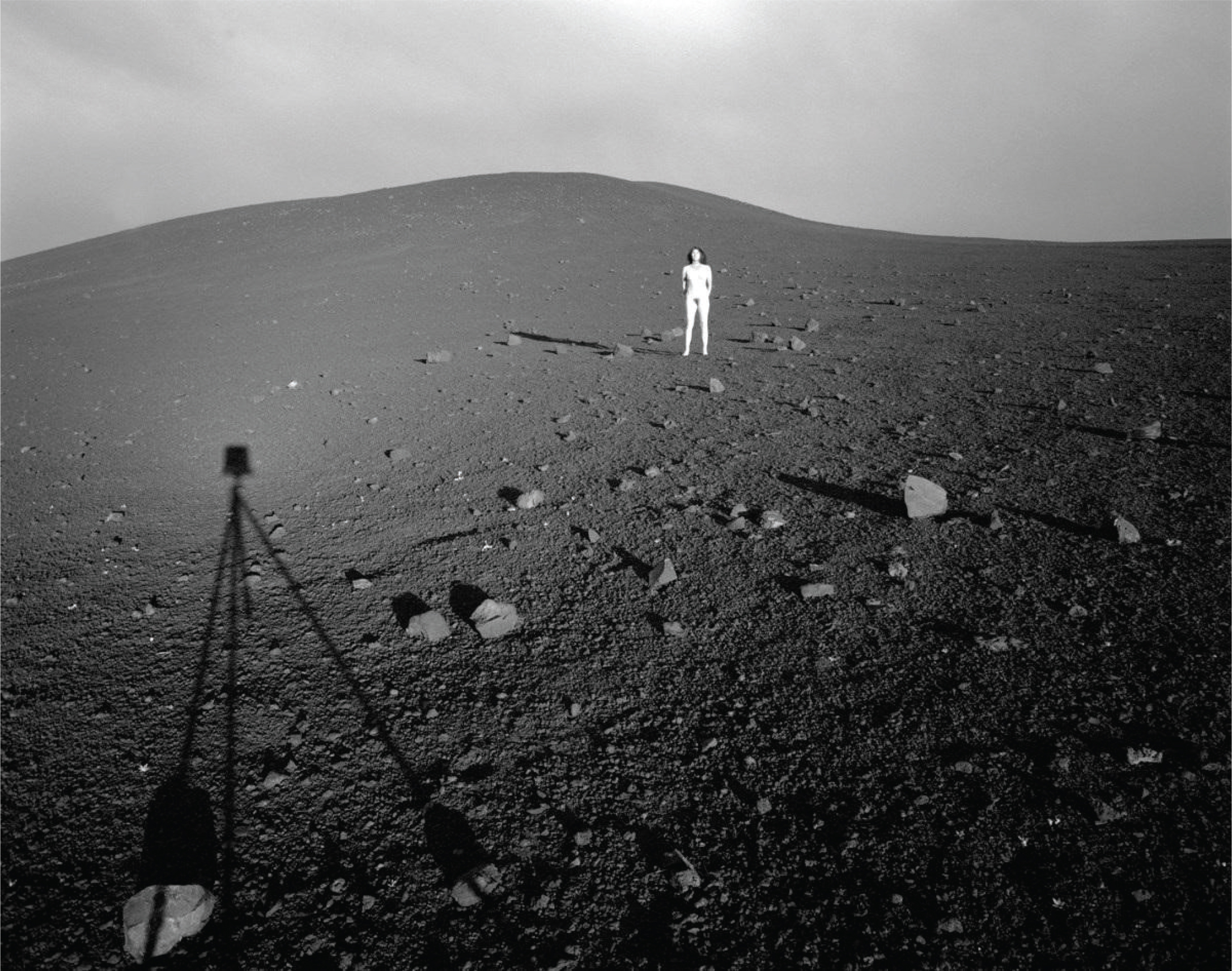
Figure 5
Judy Dater, Self-Portrait at Craters of the Moon, 1981, Gelatin silver print, 36.8 × 47 cm.
Placed side by side, these two seflies by Ginny and Dater mirror each other. The outlined silhouettes of the imaging apparatuses, of Ginny in the NASA image and the camera and tripod in Dater’s, are both found in the foreground of the facing left of each image. Similarly, the embodied figures of Perseverance Rover and the artist are both further afield in the background of the image, of the facing right.
There is much to be said about the juxtaposition between these two images of different contextual origins, mediums and temporalities. But what I’d like to point out here is the way that both images mark the imaging apparatus as a subject within the taking of a selfie, within a contextual operation of placemaking in a cosmic environment and what this may mean in relation to embodiment.
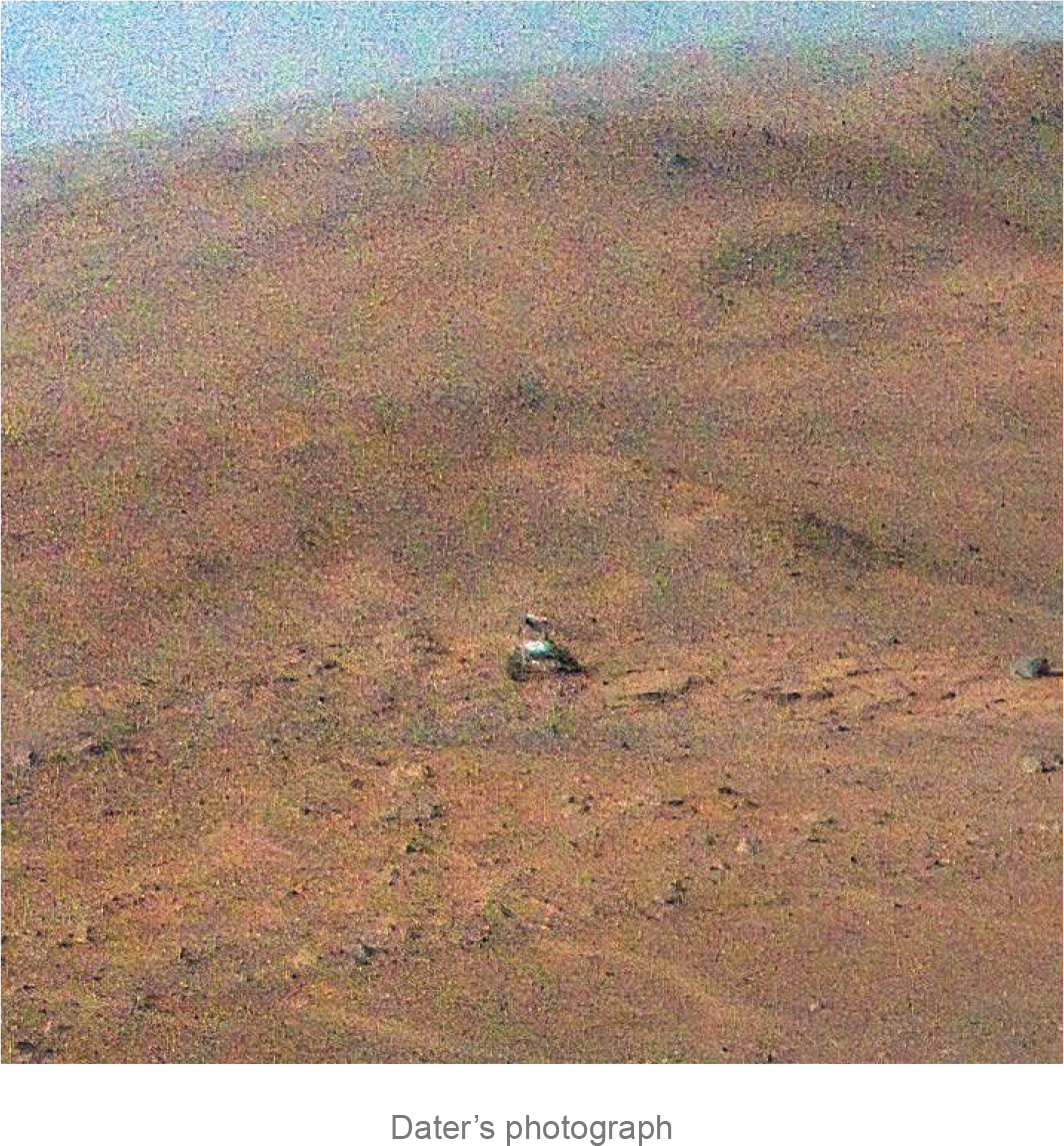
Dater’s photograph, among other attributes, has been described as blending the two image genres of landscape and self-portraiture.33 In it, the represented nakedness of the artist foregrounds the embodiment of the author of the image in relation and communion with the landscape.34 In the image taken on Mars, this embodiment could be understood as replaced by the figure of Perseverance, serving as the sensing apparatus whose embodied relationship to the Martian landscape becomes the vehicle through which we experience and visualise it. Dater’s photograph recognises both the artist and the apparatus as authors of the self-portraits. Both are recognised in relation to a landscape within which they are enveloped as well as implicated in its making into an image. Ginny’s selfie illuminates a departure of the latter, in representing authorship in another form of embodiment. It captures a machinic subjectivity depicting the logistics of our perception as they become substituted and embodied through two televisual apparatuses, both Perseverance and Ginny.
In their ongoing operational role of data and material accumulation of Mars, Perseverance and Ginny play a pivotal role in its environing, (re)shaping its landscape through their embodied point of view. The machinic selfie taken by Ginny also holds a speculative perspective towards the environing potential of these technologies. They environ the landscape of Mars by mapping its surface terrain, measuring, and accumulating data about its chemical composition, that is showing us in a specific way the physical world of Mars, thereby framing and expanding our understanding of what Mars as an environment is and possibly can be. Yet, through the captured material presence in Ginny’s selfie, Perseverance is presented not only in the act of accumulating data about Mars – but as one of its first inhabitants – seen in the process of becoming part and partial to the Martian landscape.
5 Conclusion
These images of technological photobombing and selfies represent environments that we do not inhabit, but that, through the proximity of their image, enter our imaginary and become spaces we see and know. In their obstruction and presentation of partial views, they give visibility to the logistics of technological perception that extend our sense perceptions and embody our forms of navigation at planetary scales. These images could be considered the B-side, or the alternative to the kinds of remote perspectives that privilege an all-seeing position from nowhere. Often approached as unplanned images that obscure the objects of scientific inquiry, these images instead make visible the subject of material infrastructures of the televisual in ways in which they become environments. As opposed to other mediated images of the sky and cosmos that are characterised by an aesthetics of the sublime such as35, those constructed through the Hubble telescope, the unintentional and interventionist images that document the material infrastructures of technologies ‘getting in the way’ and presenting themselves in atmospheric environments instead expose the sleight of hand in atmospheric mediation. Less speaking a visual language that communicates ideologies of expansion and exploration, conveying characteristics of heroism or dominance over nature, instead these new images reflect how we’ve become accustomed to seeing and being seen through the ubiquity of social networks. They represent both the unintentional and the performative, marking the increased ubiquity of technical objects of seeing within the ever-congested site of the earth’s atmosphere and above. In extending a theory of environing to images of environing technologies, I propose a speculative counter to the binary between technology and nature, whereby environments are primarily known through the remote sensing of wireless technologies. The visibility of their material infrastructures when framed through the image genres of photobombing and selfies, represent a process of environing as something that becomes fundamental to the cosmos. Technologies environ not only through their visual data output but also through their material selves, coalescing with the environments they surveil.
Acknowledgements
The author would like to thank the following readers for their informed, supportive and encouraging feedback: Kristen Veel, Lukáš Likavčan, Brooke Belisle, Kris Paulsen, Lindsey Caplan, Tobias Olofsson, Isak Engdahl and Alison Gerber and the editors and anonymous peer reviewers of this special themed issue.
Funding Information
This article is part of, ‘Show & Tell’, a project funded by the European Research Council (ERC) under the European Union’s Horizon 2020 research and innovation program (Grant agreement No. 949050).
Notes
[1] See Caren Kaplan, Aerial Aftermaths: Wartime From Above (Durham: Duke University Press, 2017); Nicholas Mirzoeff, The Right to Look: A Counterhistory of Visuality (Durham and London: Duke University Press, 2011); Donna Haraway, “Situated Knowledges: The Science Question in Feminism and the Privilege of Partial Perspective”, Feminist Studies 14, no. 3 (1988): 575–99.
[2] Lisa Parks, Cultures in Orbit: Satellites and the Televisual (Durham & London: Duke University Press, 2005), 12.
[3] Sverker Sörlin & Nina Wormbs, “Environing technologies: a theory of making environment”, History and Technology, 34, no 2, 101–125 (2018).
[4] Etienne Benson, Johan Gärdebo, Sabine Höhler, Karena Kalmbach, and Nina Wormbs, “Environing Technology”, Anthropocene Curriculum, 2017, https://www.anthropocene-curriculum.org/project/anthropocene-campus-philadelphia/environing-technology.
[5] Michael Kan, “A Starlink Satellite Might Have Photobombed Google Maps”, PCMag, April 14, 2025, https://www.pcmag.com/news/a-starlink-satellite-might-have-photobombed-google-maps; Sarah Wild, “Satellites Are Photobombing Astronomy Data – Could AI Offer a Solution?” Nature, September 26, 2024, https://www.nature.com/articles/d41586-024-03146-2.
[6] Yasmin Ibrahim, “The vernacular of photobombing: The aesthetics of transgression”, Convergence 25, no. 5-6 (2019), 1112.
[7] Katie Warfield, “Making Selfies/Making Self: Digital Subjectivities in the Selfie”, presented at the Canadian Communication Association Conference, 2014.
[9] Sandra Erwin, “AI Startup Using Satellite Imagery to trace the path of Chinese balloon”, Space News, February 17, 2023, https://spacenews.com/ai-startup-using-satellite-imagery-to-trace-the-path-of-chinese-balloon/.
[11] Paul Virilio, (trans. Patrick Camiller) War and Cinema: The Logistics of Perception (London & New York: Verso Books, 1989).
[12] Courtney Kube and Carol E. Lee, “Chinese spy balloon gathered intelligence from sensitive US military sites, despite US efforts to block it”, NBC News, April 3, 2023, https://www.nbcnews.com/politics/national-security/china-spy-balloon-collected-intelligence-us-military-bases-rcna77155.
[13] Dual use technology originally referred to nuclear technologies during WWII. Thank you to reviewer 2 on the application of this concept. For more on its definition see: Elisa D. Harris, “Introduction”, in Governance of Dual-Use Technologies: Theory and Practice, ed. Elisa D. Harris (Cambridge, Mass.: American Academy of Arts & Sciences, 2016); Linda Brandt, “Defense Conversion and Dual-Use Technology: The Push Toward Civil-Military Integration,” Policy Studies Journal 22, no. 2 (1994): 359–70.
[14] Although balloons seem intractable as apparatuses for reconnaissance, they have the advantage of being less remote, in other words providing a sharper view when it comes to images, and moving at a slower pace in order to capture data continuously over a target, conjoining the prime characteristics of reconnaissance satellites in low earth orbit with geosynchronous orbit.
[15] For more on a visual history of balloon surveillance see Kathrin Maurer, “Ballooning as a Technology of Seeing in Jean Paul’s Des Luftschiffers Giannozzo Seebuch (1801)”, in Before Photography: German Visual Culture in the Nineteenth Century, ed. Kirsten Belgum, Vance Byrd, and John D. Benjamin (Berlin and Boston: De Gruyter, 2021), 17–38.
[16] Matthew Brown and James Pollard, “Eyes on the Sky as Chinese Balloon Shot Down Over Atlantic”, AP News, February 5, 2023, https://apnews.com/article/politics-montana-north-carolina-302134762e8aeae53314ebd9fdb327e4.
[17] Iain Boyd, “Chinese spy balloon over the US: An aerospace expert explains how the balloons work and what they can see”, The Conversation, February 4, 2023. https://theconversation.com/chinese-spy-balloon-over-the-us-an-aerospace-expert-explains-how-the-balloons-work-and-what-they-can-see-199245.
[18] The ‘novel awareness’ mentioned here being privileged to situated regions of non-military zones as opposed to areas under constant drone surveillance.
[19] For more on the history of categorical distinctions of the Karman Line see McDowell, Jonathan C. “The edge of space: Revisiting the Karman Line”, Acta Astronautica 151 (2018): 668–677.
[21] This visual uniformity also corresponds with critical notions towards Hubble images described as ‘star factories’ as mentioned by Parks, and that they have been used to position stars as ‘products of assembly lines’. See Parks, Cultures in Orbit, 151.
[22] Shannon Hall, “After SpaceX Starlink Launch, a Fear of Satellites That Outnumber All Visible Stars”, The New York Times, June 1, 2019, https://www.nytimes.com/2019/06/01/science/starlink-spacex-astronomers.html; Rebecca Boyle, “Satellite Constellations are an Existential Threat for Astronomy”, Scientific American, 2 November 2022, https://www.scientificamerican.com/article/satellite-constellations-are-an-existential-threat-for-astronomy/
[23] Jonathan McDowell, Orbiting Now: Active Satellite Orbit Data, April 25, 2025, https://orbit.ing-now.com/#google_vignette; Teresa Pultarova, “Starlink satellites: Facts, tracking and impact on astronomy”, Space.com, 28 March 2025, https://www.space.com/spacex-starlink-satellites.html.
[24] Victoria Kim, “Elon Musk Acknowledges Withholding Satellite Service to Thwart Ukrainian Attack on Russia”, The New York Times, September 8, 2023, https://www.nytimes.com/2023/09/08/world/europe/elon-musk-starlink-ukraine.html.
[26] Skibba, Ramin, “Satellites Keep Photobombing Space Images. Astronomers Need a Fix”, Wired, June 13, 2023.
[29] NASA Science, Mars 2020 Mission Perseverance Rover, https://mars.nasa.gov/mars2020/.
[30] NASA Science, Mars Perseverance Raw Images, https://mars.nasa.gov/mars2020/multimedia/raw-images/.
[31] For more on a study of placemaking in outer space, see: Lisa Messeri, Placing Outer Space : An Earthly Ethnography of Other Worlds (Duke University Press, 2016).
[32] The name was given to the landscape by geologist, Harold T. Stearns in 1923 based on notions that its surface resembled the moon, whereby astronauts of the Apollo missions of 1969–1972 performed part of their training on this site. It was not until these missions were actualised and the lunar landscape was experienced directly and through photographic capture by these astronauts that it was realised that the lunar landscape did not at all resemble the volcanic fields in Idaho. See National Park Service, Craters of the Moon: National Park Handbook no. 139 (Washington, D.C.: National Park Service Division of Publications, 1991).
[33] The Metropolitan Museum of Art, “Self-Portrait at Craters of the Moon”, 2024, https://www.metmuseum.org/art/collection/search/789238.