
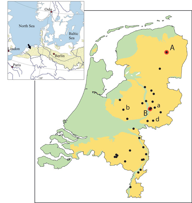
Figure 1
Research area: the sandy soils of the Netherlands (yellow), forming part of the western section of the European aeolian sand belt (top-left; after Hilgers, 2007). The distribution of sites with well-dated pit kilns is indicated (black dots). Dates range from c. 200 BC to c. AD 1400. The case study sites described in the text are A: Anloo-Bosweg, B: Zutphen-Looërenk. Other sites referred to in the case studies are a: Almen-Asselerweg, b: Barneveld-Harselaar, d: Doetinchem-Lookwartier.

Figure 2
‘Reverse image’ model of landscape transformation over time due to intensified land use. Densely wooded landscapes with isolated clearings transform into open landscapes with isolated clumps of woodland (almost becoming a reverse picture of the former landscape) (after Groenewoudt et al., 2007).
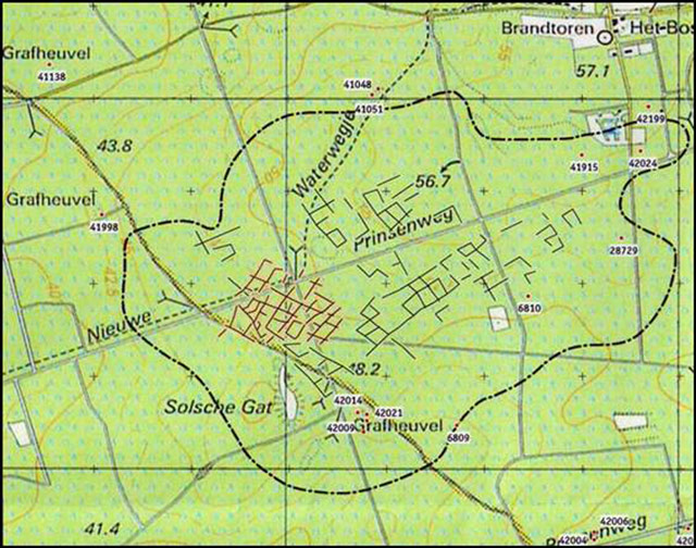
Figure 3
Traces of a late prehistoric field system of the Celtic Field type under ‘ancient woodland’ mapped on a recent topographical map, scale 1: 25.000. Speulder- en Sprielderbosch, Veluwe area, the Netherlands (after Willemse et al., 2008). Lines: field banks still recognisable. Dotted line: area with remains visible on LIDAR images.
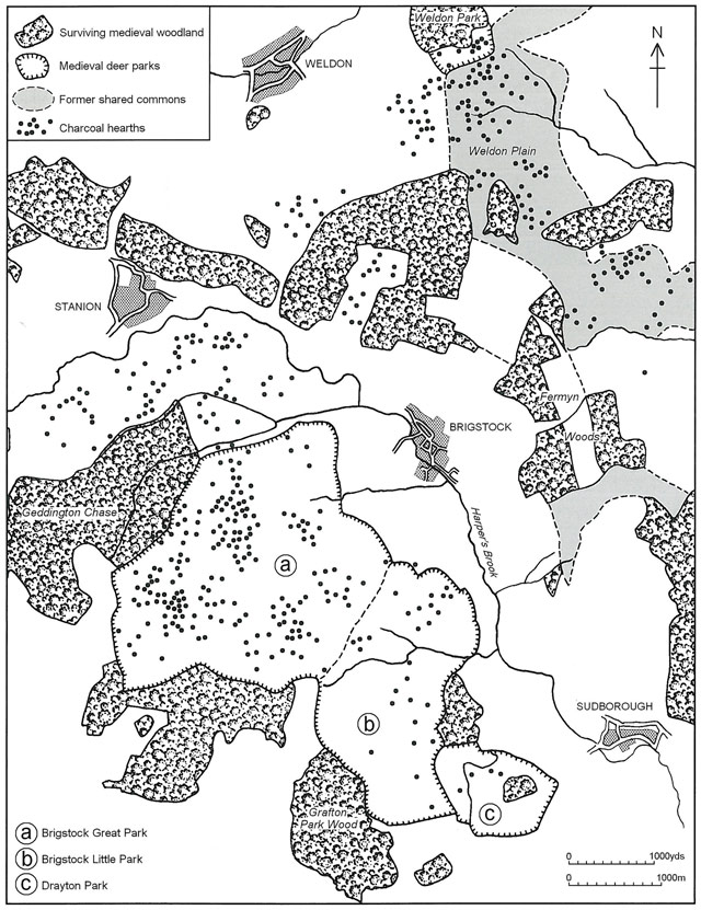
Figure 4
Distribution of charcoal hearths in Rockingham Forest (UK), allowing a detailed reconstruction of the woodland contours in the 13th to 14th centuries (after Foard, 2001).
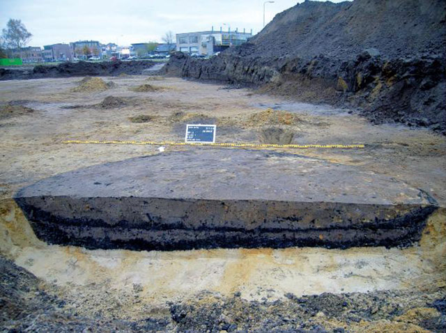
Figure 5
Archaeological remains of a pit kiln under excavation (site: Barneveld; after Brouwer, 2012).
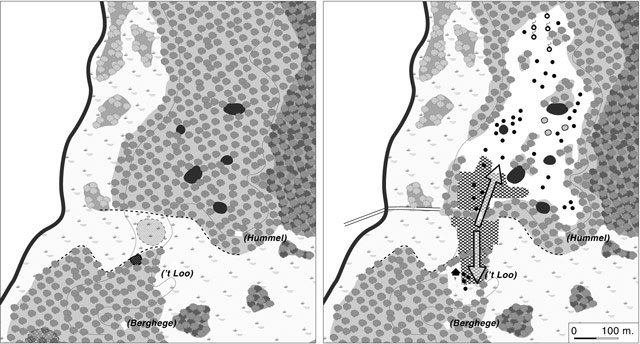
Figure 6
Zutphen-Looërenk. Shading in different greys indicates different types of woodland. Large black dots are small natural depressions and meres. Left panel: Natural woodland regeneration (c. 1st to 9th centuries AD) on a site that previously was settled open land (names indicate later Medieval farm sites). Right panel: Reclamation (c. 10th century) following charcoal production (c. 9th century). The kiln sites are schematically indicated as small black dots. Charcoal production and subsequent reclamation started (arrows) at a site (‘t Loo’) that had remained open after the settlement was abandoned because it was probably used as pasture land (after Groenewoudt, 2006). Further explanation in the text.
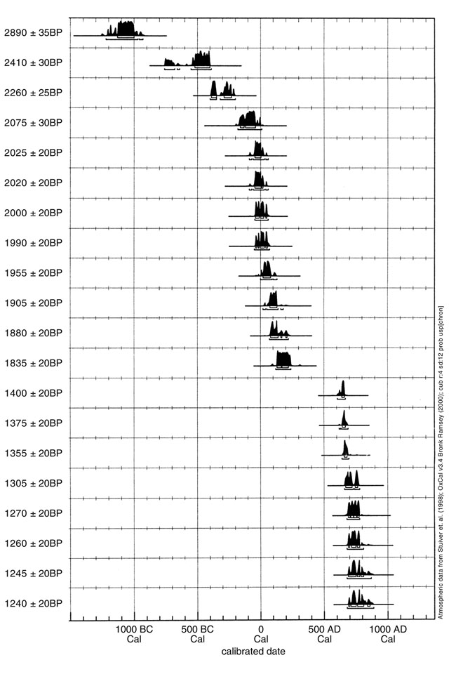
Figure 7
Anloo-Bosweg. Radiocarbon dates of charcoal from pit kilns interpreted as two phases of charcoal production using wood from secondary woodland. X-axis: age in calibrated years BC/AD with the probability distribution of the calibrated 14C dates. Y-axis: 14C dates in years BP. The two oldest dates (top) are related to settlement activity preceding charcoal production (and the local presence of woodland).
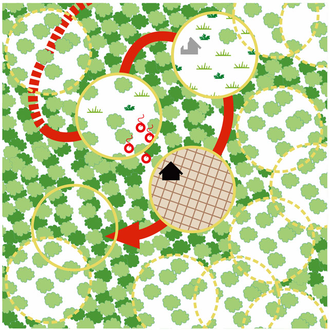
Figure 8
Proposed model of settlement mobility (“micro-mobility”) influencing the presence, type and composition of woodland and openness of woodland) on Pleistocene sandy soils in the Netherlands. Primeval or secondary woodland became increasingly open over time as a result of soil degradation and intensified land use. This model is based on the combination of data on settlement and charcoal production (red symbols). The establishment of settlements and agricultural land use cause deforestation. Circles represent (former) settlements and associated fields. Settlement relocation causes reforestation at former settlement sites. The local presence of secondary woodland is demonstrated by archaeological remains of charcoal kilns.