
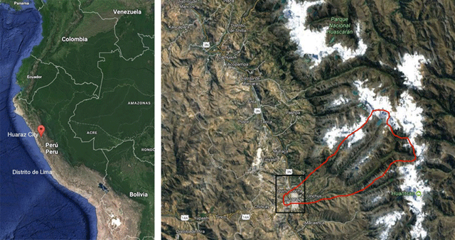
Map 1 and Map 2
Location of Huaraz. The Quillcay River basin is indicated with the red line. Source: Edited by the author, based on Google Maps 2017.
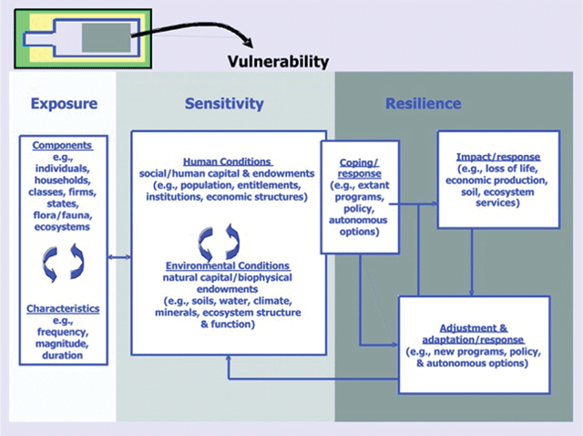
Figure 1
Place-dimension of vulnerability framework of the Research and Assessment System for Sustainability Program by Turner et al. (2003b) applied in this study.
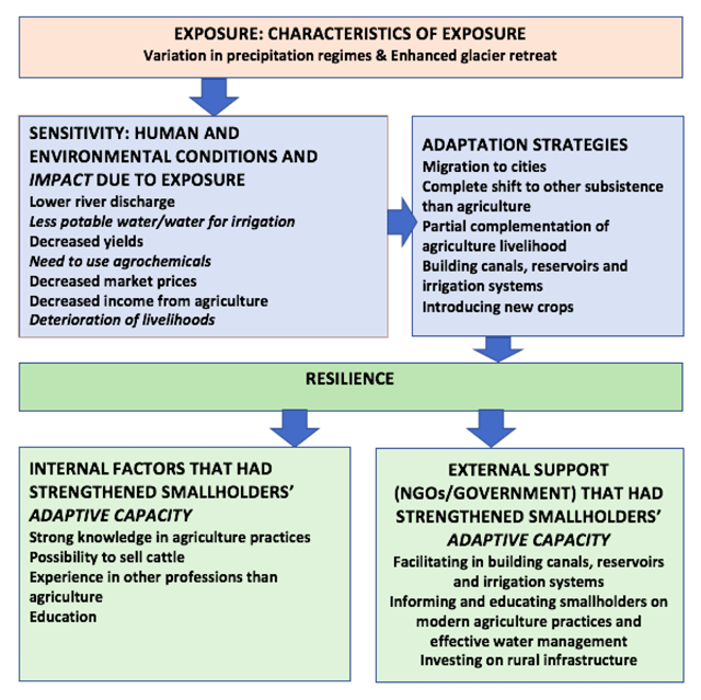
Figure 2
Factors that had affected smallholders’ vulnerability in the Quillcay River basin, adaptation strategies in use and factors strengthening adaptive capacity to enhance resilience. Source: Author, based on vulnerability framework of Turner et al. (2003b).
Table 1
Correlations between climate proxies and socioeconomic factors. Upper value indicates the correlation (r) and value in parenthesis one-tailed significance level (p). Source: Author, based on the data obtained from MINAGRI, INEI and ANA.
| Harvest Corn | Harvest Potato | Harvest Wheat | Price Corn | Price Potato | Price Wheat | Rural Population | |
|---|---|---|---|---|---|---|---|
| Retreat | 0.495 (0.000) | 0.466 (0.001) | 0.524 (0.000) | 0.011 (0.473) | –0.012 (0.496) | 0.028 (0.428) | –0.257 (0.046) |
| Precipitation | 0.077 (0.310) | 0.042 (0.394) | 0.205 (0.091) | 0.210 (0.086) | 0.208 (0.088) | 0.185 (0.114) | –0.164 (0.144) |
Table 2
Results of linear regressions analysis. Coefficient of determination (r2) presented above and statistical significance (p) below in parenthesis. Source: Author, based on the data obtained from MINAGRI, INEI and ANA.
| Harvest Corn | Harvest Potato | Harvest Wheat | Price Corn | Price Potato | Price Wheat | Rural Population | |
|---|---|---|---|---|---|---|---|
| Retreat | 0.246 (0.001) | 0.217 (0.002) | 0.301 (0.000) | 0.044 (0.969) | 0.044 (0.852) | 0.034 (0.931) | 0.087 (0.108) |
| Precipitation | 0.246 (0.782) | 0.217 (0.972) | 0.301 (0.217) | 0.044 (0.178) | 0.044 (0.177) | 0.034 (0.238) | 0.087 (0.342) |