
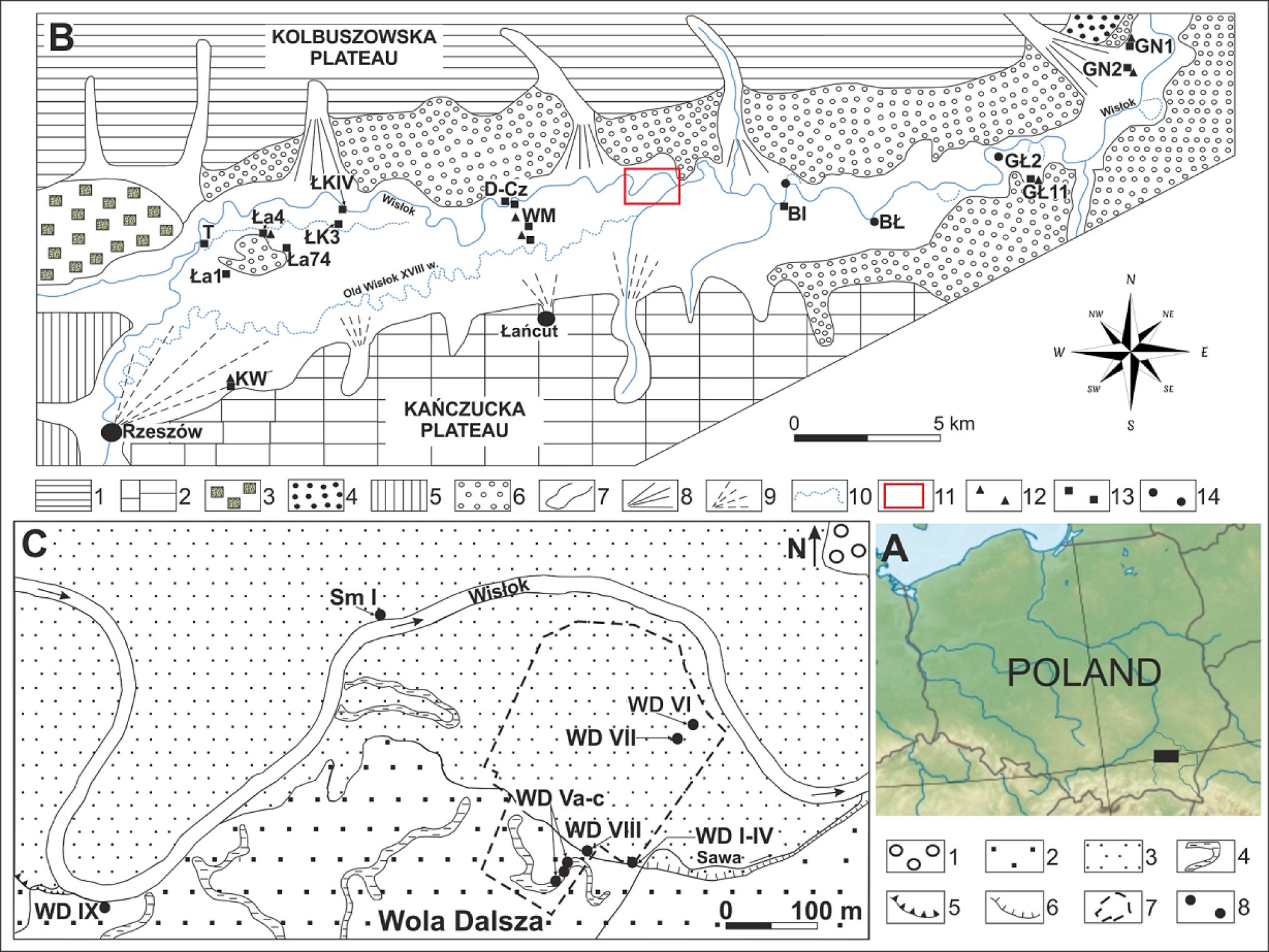
Fig. 1
Maps with location and geomorphology of study area.
General location of the study area.
The Wisłok River valley and the Late Glacial and Holocene alluvia with sites sampled for the radiocarbon datings (elaborated by P. Gębica). Explanation of symbols: 1 – Kolbuszowska Plateau covered with sediments of the Elsterian Glaciation, 2 – Kańczucka Plateau covered with Saalian 2 (Wartanian) and Vistulian loess, 3 – fluvioglacial plain, Elsterian 2 Glaciation, 4 – river terrace 13–18 m high, Saalian 2 (Wartanian), 5 – loess terrace 15–20 m high, Vistulian, 6 – Vistulian (sandy) terrace 8–12 m high, with dunes, 7 – erosional-denudation valley, 8 – Pleistocene alluvial fan, 9 – Holocene alluvial fan, 10 – Holocene floodplain 7–8 m high and systems of palaeochannels, 11– study area, 12 – sites of the Late Glacial sediments, 13 – sites of the Early Holocene sediments, 14 – sites of the Last Millenium sediments. List of the sites dated by radiocarbon and palynological methods: SŁ – Słocina, KW – Krasne-Wólka, Ła1 – Łąka 1, Ła4 – Łąka 4, T – Terliczka, Ła 74 – Łąka archaeological site No. 74, ŁkIV – Łukawiec IV, Łk3 – Łukawiec 3, CzP – Czarna Podbór, D-Cz – Dąbrówki-Czarna, WM – Wola Mała, BI – Białobrzegi, BŁ – Budy Łańcuckie, GŁ2 – Gniewczyna Łańcucka 2, GŁ11 – Gniewczyna Łańcucka 11, GN1 – Grodzisko Nowe 1, GN2 – Grodzisko Nowe (Dolne) 2.
Wola Dalsza gravel pit and the location of sequences described in the text (elaborated by S. Superson). Explanation of symbols: 1 – Vistulian sandy terrace 8–12 m high, 2 – Holocene terrace 7–8 m high, 3 – floodplain 5–6 m high, 4 – palaeochannels, 5 – erosional edges higher than 1 m, 6 – erosional edges up to 1 m high, 7 – extent of gravelpit, 8 – study sites, Sm – Smolarzyny site.
Table 1
Radiocarbon datings of samples from the sequence in the Wola Dalsza gravel-pit.
| Sample no. | Name of the profile | Terrace level (m) | Dated material | Depth (m) | Laboratory no. | Age 14C (BP) | Calendar Age (calibrated) range 68% | Calendar Age (calibrated) range 95% |
|---|---|---|---|---|---|---|---|---|
| 1 | Wola Dalsza Vb | 7–8 | charcoals | 0.60–0.80 | ---------- | no dated | ---------- | ---------- |
| 2 | Wola Dalsza Va | 7–8 | coal dust | 1.50–1.60 | ---------- | no dated | ---------- | ---------- |
| 3 | Wola Dalsza Vc | 7–8 | wood | 4.60–4.65 | GdS-1920 | 10100±140 | 11960–11860 cal BP (11.2%) 11845–11395 cal BP (57.0%) | 12370–12350 cal BP (0.3%) |
| 12235–12205 cal BP (0.5%) | ||||||||
| 12170–11235 cal BP (94.5%) | ||||||||
| 4 | Wola Dalsza IX | 7–8 | trunk | 5.80–5.90 | MKL-2786 | 9290±50 | 8619–8466 cal BC (68.2%) | 8699–8679 cal BC (1.8%) |
| 8641–8337 cal BC (93.6%) | ||||||||
| 5 | Wola Dalsza IV | 5–6 | peat | 3.20–3.25 | GdS-3233 | 8900±95 | 10195–9885 cal BP (68.2%) | 10230–9695 cal BP (95.4%) |
| 6 | Wola Dalsza VI | 5–6 | trunk | 3.00–3.10 | GdS-3230 | 7390±80 | 8335–8155 cal BP (64.8%) | 8365–8030 cal BP (95.4%) |
| 8085–8065 cal BP (3.4%) | ||||||||
| 7 | Wola Dalsza VII | 5–6 | peat | 4.70–4.80 | GdS-3056 | 9085±65 | 10370–10355 cal BP ( 2.9%) | 10490–10455 cal BP (1.5%) |
| 10300–10185 cal BP (65.3%) | 10440–10155 cal BP (93.9%) | |||||||
| 8 | Wola Dalsza VIII | 5–6 | peat | 4.50–4.60 | GdS-3228 | 9575±95 | 11095–10915 cal BP (37.0%) | 11195–10655 cal BP (95.1%) |
| 10910–10755 cal BP (31.2%) | 10615–10605 cal BP ( 0.3%) | |||||||
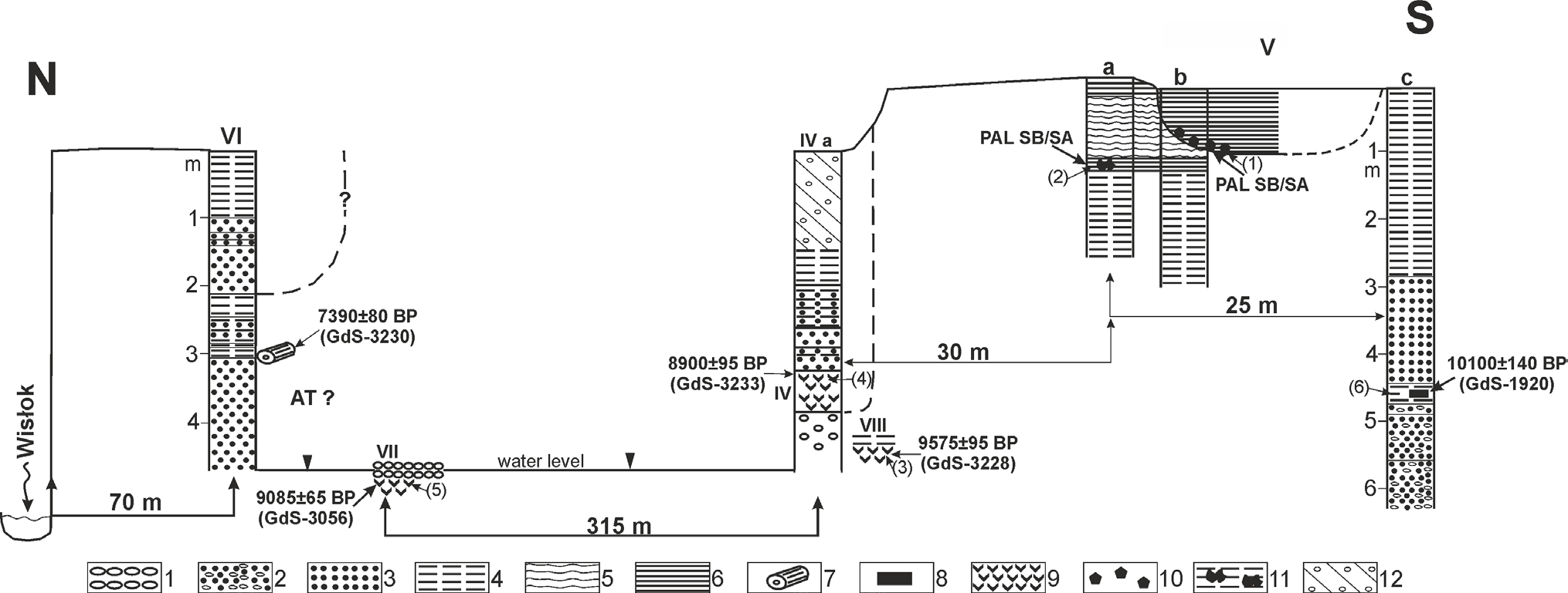
Fig. 2
Geological cross-section of the floodplain (5–6 m high) and terrace 7–8 m high with the location of the sequences and samples dated by the radiocarbon and palynological methods (elaborated by S. Superson). Explanation of symbols: 1 – gravel, 2 – sand with single pebbles, 3 – sand, 4 – silt, 5 – flood rhytmithe, 6 – clay, 7 – tree trunks, 8 – wood fragments, 9 – peat, 10 – charcoal fragments, 11 – fired clay bearing coal dust, 12 – anthropogenic embankment; PAL-palynological dating, AT-Atlantic, SB-Subboreal, SA-Subatlantic
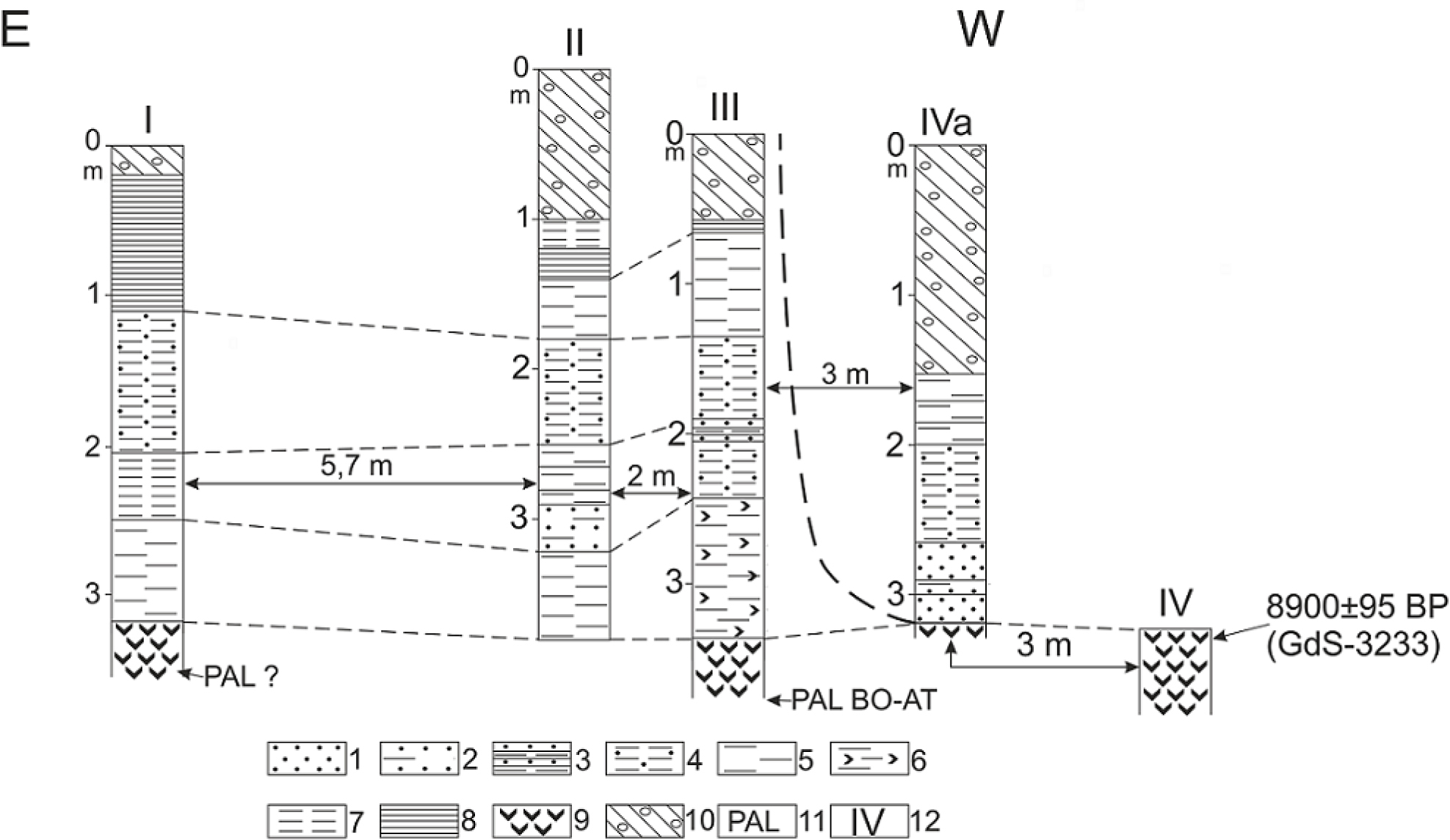
Fig. 3
The structure of floodplain 5–6 m high bearing peat, eroded in the sequence IV (elaborated by S. Superson and P. Gębica). Explanation of symbols: 1 – sand, 2 – silty sand, 3 – laminated sand, 4 – silt with sand, 5 – silt, 6 – organic silt, 7 – clayey silt, 8 – clay, 9 – peat, 10 – anthropogenic embankment, 11 – palynological analysis, 12 – number of the sequence; Bo-Boreal, AT-Atlantic.
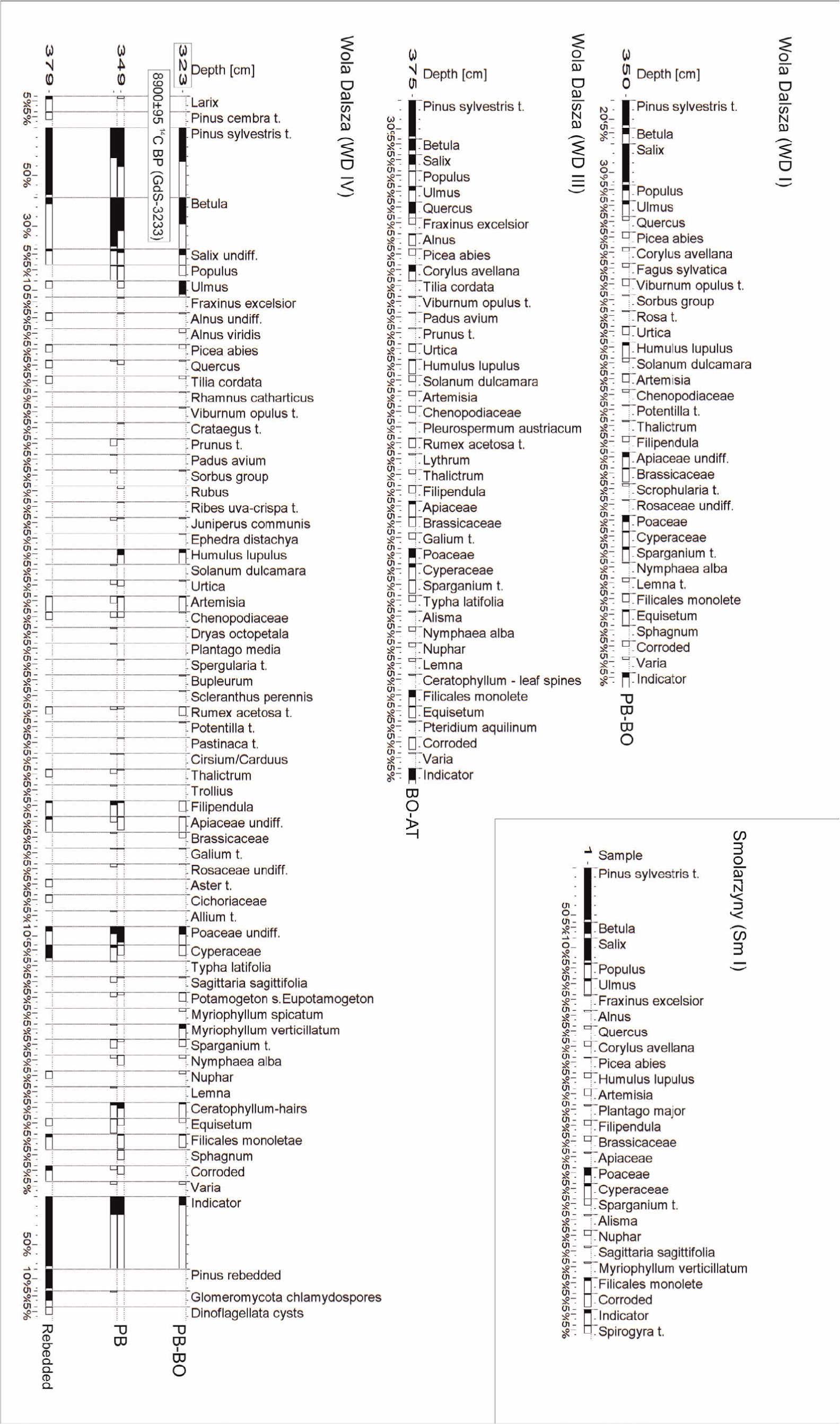
Fig. 4
Palynological diagrams of the Wola Dalsza and Smolarzyny sequences (analysed by P. Kołaczek).
Table 2
The results of palynological analysis (amount of pollen grain) of six samples of organic sediments from the Wola Dalsza site (analysed by K. Szczepanek).
| Profile number Sample number depth (m) | Vb 1 0.6–0.8 | Va 2 1.5–1.6 | VIII 3 4.5–4.6 | IV 4 3.20–3.25 | VII 5 4.7–4.8 | Vc 6 4.60–4.65 |
|---|---|---|---|---|---|---|
| Pinus sylvestris t. | no pollan grains, charcoal: Quercus, Fraxinus, Carpinus | no pollan grains, coal dust | 213 | 210 | 160 | no pollan grains |
| Betula sp. | 25 | 101 | 72 | |||
| Ulmus | 11 | 65 | 46 | |||
| Quercus | 106 | 3 | 9 | |||
| Salix | 46 | 48 | 58 | |||
| Corylus | 17 | 5 | 4 | |||
| Alnus | 1 | 1 | 0 | |||
| Picea | 3 | 3 | 2 | |||
| Tilia | 2 | 0 | 0 | |||
| Larix | 0 | 1 | 0 | |||
| Poaceae | 20 | 17 | 35 | |||
| Cyperaceae | 4 | 3 | 5 | |||
| Artemisia | 4 | 4 | 5 | |||
| Brasicaceae | 10 | 5 | 1 | |||
| Rosaceae | 8 | 6 | 1 | |||
| Rubiaceae | 1 | 1 | 0 | |||
| Chenopodiaceae | 0 | 1 | 0 | |||
| Caryophyllaceae | 3 | 1 | 0 | |||
| Asteraceae | 0 | 1 | 1 | |||
| Apiaceae | 16 | 15 | 9 | |||
| Sparganium | 8 | 8 | 9 | |||
| Myriophyllum | 0 | 23 | 14 | |||
| Nuphar, Nymphaceae | 0 | 1 | 2 | |||
| Lemna | 1 | 0 | 0 | |||
| Humulus-Cannabis t. | 2 | 3 | 3 | |||
| Equisetum | 2 | 0 | 0 | |||
| Lycopodium | 1 | 0 | 0 | |||
| Polypodiaceae | 14 | 5 | 8 | |||
| Varia | 8 | 2 | 4 | |||
| Sum AP | 424 | 437 | 351 | |||
| Sum NAP | 102 | 96 | 97 |
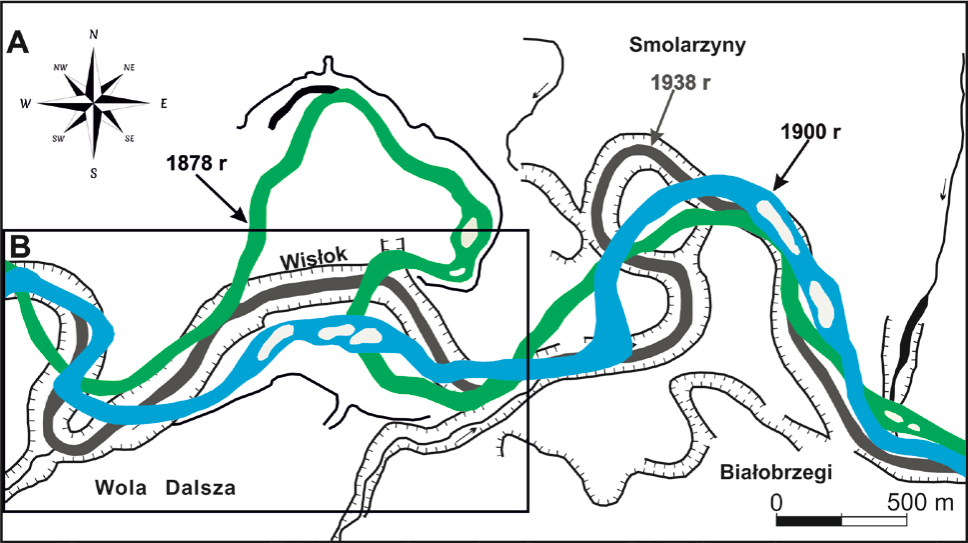
Fig. 5
Changes of the Wisłok River channel during the 19th and 20th centuries (elaborated by S. Superson). A. Changes of the Wisłok Rivet channel between Wola Dalsza and Białobrzegi, B. The area presented on Fig. 1C in detail.